
August 21 , 2020.
Indonesia , Sinabung :
3.17°N, 98.392°E
Elevation 2460 m
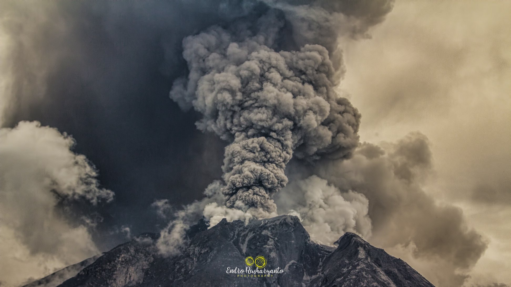
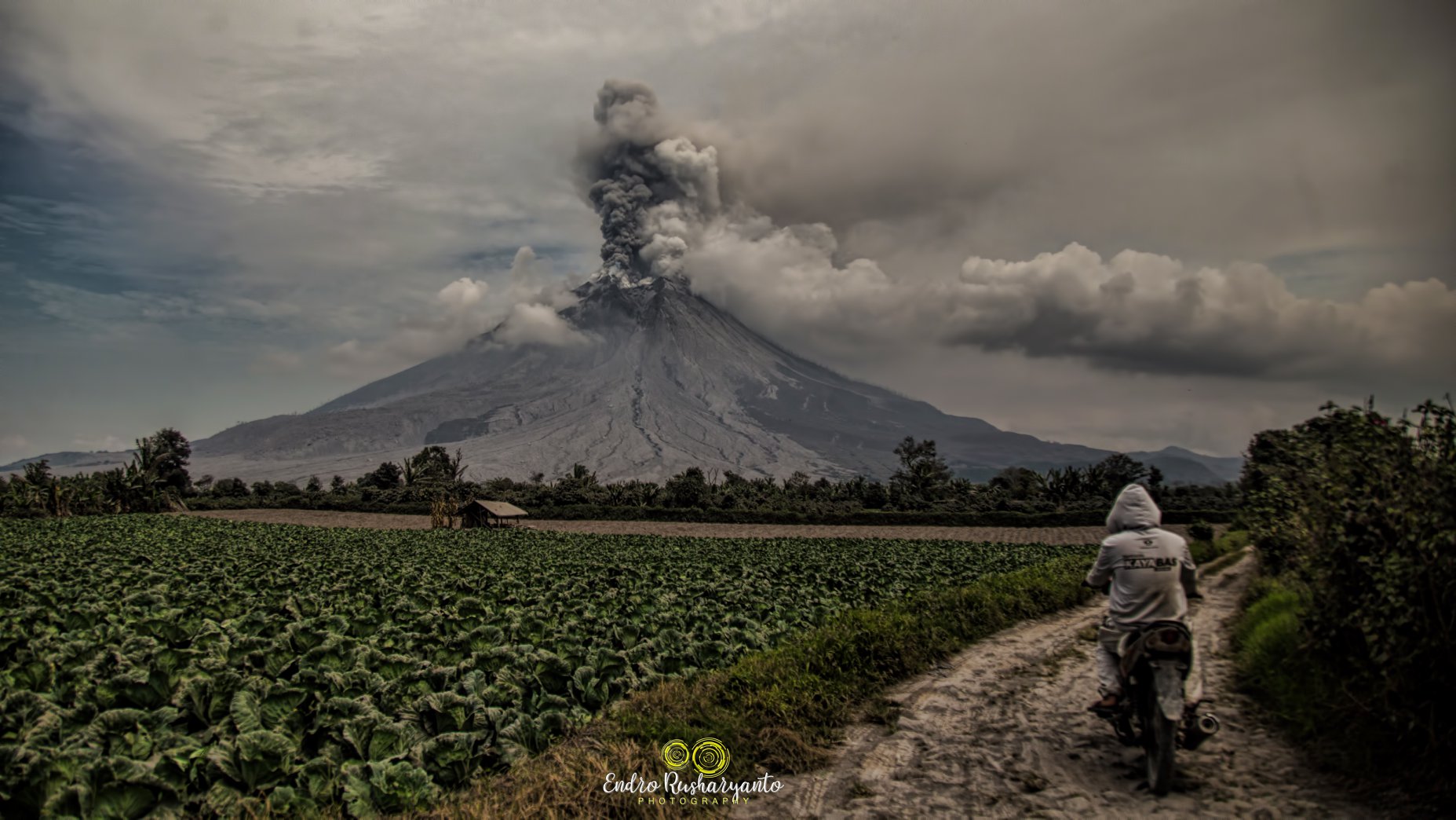
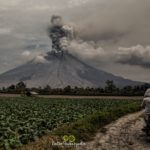
PVMBG reported that white-and-gray plumes rose 200 m above Sinabung’s summit and drifted E and SE on 12 August. A series of seven eruptions late on 13 August generated ash plumes that rose as high as 2 km and drifted E, SE, and S. The first event, at 0607, lasted for 12 minutes and produced an ash plume that rose 2 km according to BNPB. Seismicity was dominated by continuous tremor during the series. Eruptive events at 1030, 1425, and 1455 on 14 August produced ash plumes that rose as high as 2.1 km and drifted SSE and ESE. An ash plume from an event at 1656 rose 4.2 km and drifted E. At 1724 on 17 August an ash plume rose 1.5 km and drifted SE. Ash plumes rose as high as 2 km on 18 August. The Alert Level remained at 3 (on a scale of 1-4), with a general exclusion zone of 3 km and extensions to 5 km on the SE sector and 4 km in the NE sector.
VOLCANO OBSERVATORY NOTICE FOR AVIATION – VONA.
Issued : August 19 , 2020
Volcano : Sinabung (261080)
Current Aviation Colour Code : RED
Previous Aviation Colour Code : orange
Source : Sinabung Volcano Observatory
Notice Number : 2020SIN18
Volcano Location : N 03 deg 10 min 12 sec E 98 deg 23 min 31 sec
Area : North Sumatra, Indonesia
Summit Elevation : 7872 FT (2460 M)
Volcanic Activity Summary :
Eruption with volcanic ash cloud at 11:23 UTC (18:23 local). Eruption and ash emission is continuing.
Volcanic Cloud Height :
Best estimate of ash-cloud top is around 20672 FT (6460 M) above sea level, may be higher than what can be observed clearly. Source of height data: ground observer.
Other Volcanic Cloud Information :
Ash-cloud moving to east-southeast
Remarks :
Seismic activity is characterized by continuous volcanic tremor.
Sources: PVMBG, Darwin Volcanic Ash Advisory Center (VAAC), BNPB , Magma Indonésie .
Photo : Endro Rusharyanto .
Italy / Sicily , Etna :
Weekly bulletin, from August 10, 2020 to August 16, 2020
(date of issue August 18, 2020)
SUMMARY OF THE STATE OF ACTIVITY
In the light of the surveillance data, it is highlighted:
1) VOLCANOLOGICAL OBSERVATIONS: Explosive activity at the New Southeast Crater, the Northeast Crater and the Voragine Crater with Strombolian activity and discontinuous volcanic ash emissions and degassing activities. Ordinary degassing of the Bocca Nuova.
2) SEISMOLOGY: The fracturing seismicity remained at very low levels; the mean amplitude of the volcanic tremor showed a fluctuating trend over a substantially stationary trend with a prevalence of mean values.
3) INFRASON: The infrasound activity was very high in the first part of the week.
4) DEFORMATIONS: The Etna soil deformation monitoring networks have not shown any significant changes over the past week.
New crater well in formation in the Bocca Nuova.
5) GEOCHEMISTRY: The flow of SO2 is at a medium-low level
the flow of HCl is at a medium-low level
The flow of CO2 emitted by the soil is at an average level.
The partial pressure of dissolved CO2 in groundwater is at average values.
There are no new measures relating to the C / S ratio (last measure dated 17/07/2020)
There is no update of the helium isotope ratio measurements (last measurement dated 07/27/2020)
6) SATELLITE OBSERVATIONS: The thermal activity in the summit area is at a medium-low level.
VOLCANOLOGICAL OBSERVATIONS:
During the week, the monitoring of the volcanic activity of the summit craters of Etna was carried out through the analysis of the images of the surveillance cameras of the INGV, Osservatorio Etneo (INGV-OE) and by the INGV staff on the ground. In the morning and afternoon of the first three days of the week (August 10, 11 and 12), the visibility conditions were greatly reduced by the presence of clouds in the summit area.
During the week, Etna’s activity was characterized by Strombolian activity at the New Southeast Crater (NSEC), at the Northeast Crater (NEC) as well as by ash emissions from the Voragine crater. (VOR), while the crater of Bocca Nuova (BN) was characterized by ordinary degassing.
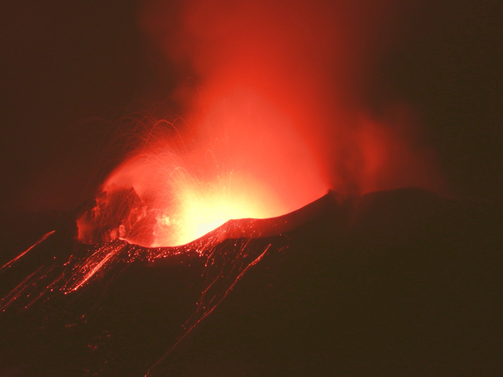
In particular, Strombolian activity at the New Southeast Crater « cono della sella » continued for most of the week. As in previous weeks, Strombolian activity underwent fluctuations in the intensity and frequency of the explosions. The most intense phases of activity threw pieces of lava up to several tens of meters above the rim of the crater and which fell on the sides of the cone. On the morning of August 10, in the absence of wind, an ash plume about 1 km high above the top of the volcano formed.

During the day of August 14, an episode of intense Strombolian activity produced significant amounts of ash, which formed a plume bent by the wind in a south-easterly direction, with fallout of ash in the area between Pedara, Trecastagni and Viagrande. In the evening, the activity diminished, with sporadic puffs of ash.
In the early afternoon of August 15, a new series of ash emissions began, associated with an increase in Strombolian activity and the formation of a discontinuous plume oriented to the Southeast. This activity decreased by the late afternoon of the same day, followed by short intervals of strombolian activity at night, which ceased shortly after sunrise on August 16. During this day, low sporadic ash emissions were observed, without any trace of hot material projection.
As in previous weeks, discontinuous intracrater Strombolian activity at the Northeast Crater continued. For a few days, loud roars were heard coming from this crater.
During the week, small sporadic ash emissions occurred in the crater of Voragine, accompanied in rare cases by the launch of incandescent material (visible in night images from surveillance cameras).
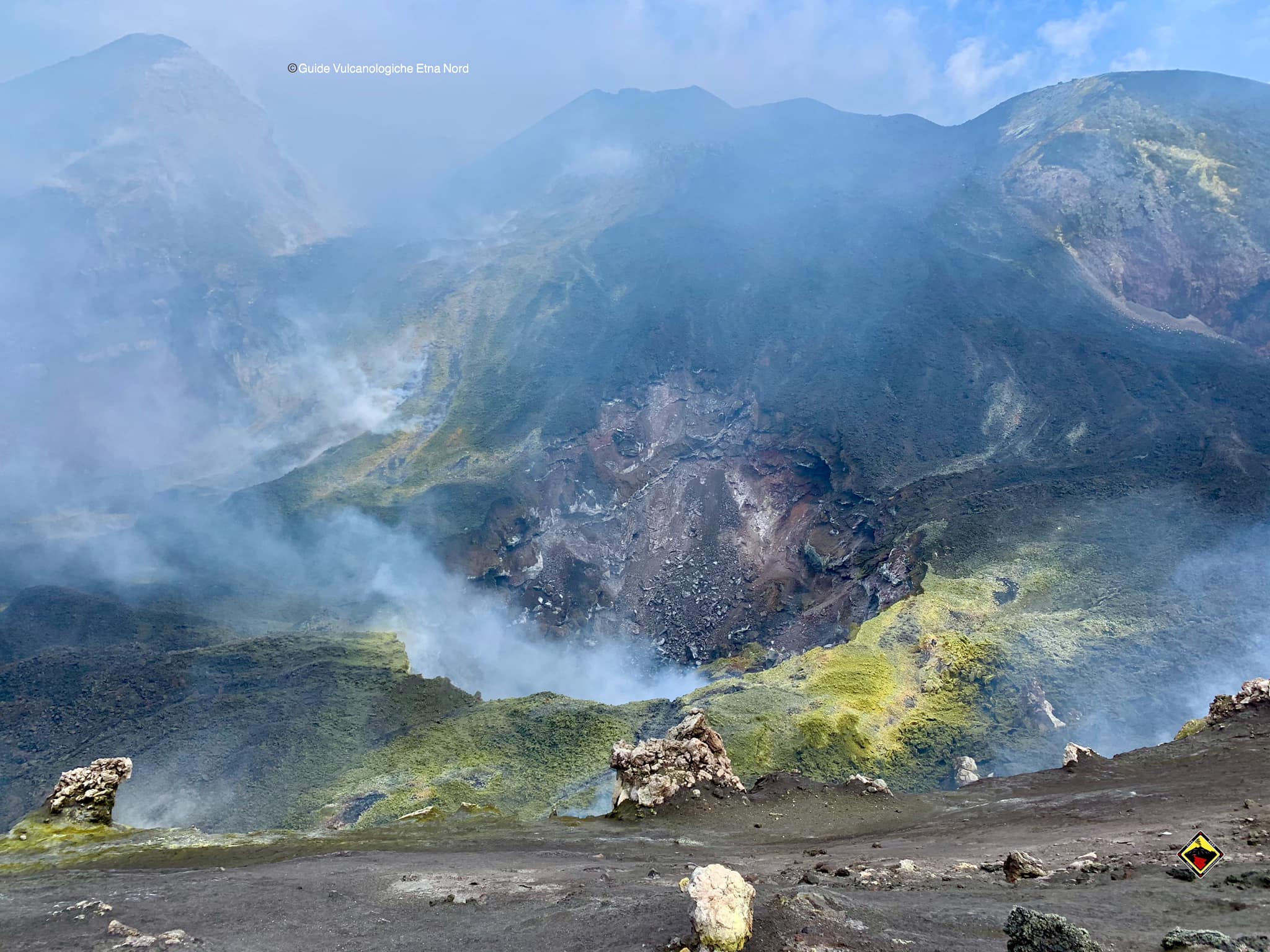
Finally, we observe a gradual widening of the vent that has been forming since April in the central part of the Bocca – Nuova, while in the western part of the crater, a zone of fumarolic activity has formed along a fracture which cuts the lava field which, coming from Voragine in September-May, filled a large part of Bocca – Nuova…
ETNA COMMUNICATION [UPDATE n. 68]
The National Institute of Geophysics and Volcanology, Osservatorio Etneo, reports that between 2:10 a.m. and 3:50 a.m. GMT, Strombolian activity at the New Southeast Crater increased in intensity, producing clasts clearly visible above the crater rim. . From 4:30 GMT on the other hand, we observe a decrease in Strombolian activity which produces sporadic and weak volcanic ash emissions which disperse rapidly in the atmosphere.
The temporal trend of the mean amplitude of the volcanic tremor continues to show fluctuations of ever greater amplitude which globally define a slightly positive trend which is maintained mainly in the interval of the mean values.
High tremors amplitude values were observed today between around 02:10 and 03:50 GMT. The location of the center of gravity of the sources of volcanic tremor remains confined to the area of the SE crater complex at an altitude of between 2900 and 3000 m above sea level.
The infrasound activity, similar to volcanic tremor, shows an oscillating trend. Between 2:00 a.m. and 3:30 a.m. around GMT, there was an increase in the number of events and their magnitude. The infrasound sources are mainly located in the area of the SE crater complex.
Analysis of the data from the permanent and inclinometric GNSS networks did not show any significant deformation of the ground. Only two upper inclinometer stations (ECPN and EPDN) appeared to show a slight variation around 03:30 GMT.
Source : INGV.
Photos : Guide Vulcanologiche Etna Nord , Gio Giusa ,
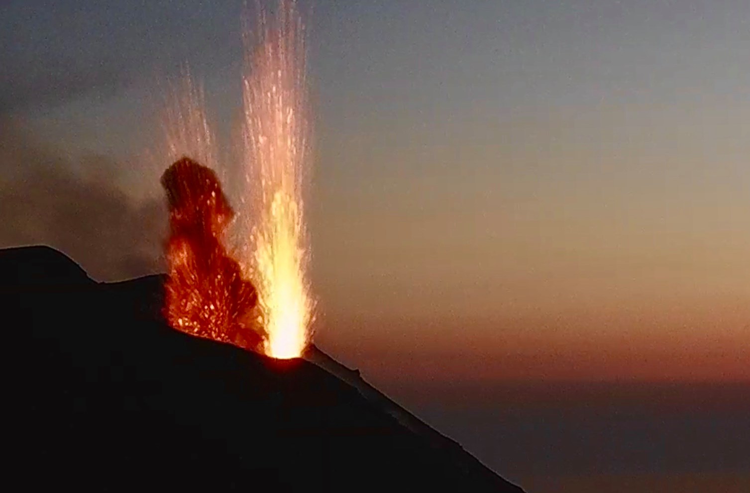
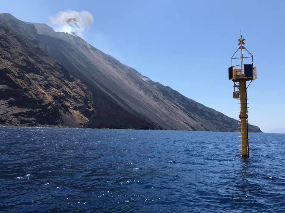
Italy , Stromboli :
Weekly bulletin, from August 10, 2020 to August 16, 2020
(date of issue August 18, 2020)
SUMMARY OF THE STATE OF ACTIVITY
In the light of surveillance data, it is highlighted:
1) VOLCANOLOGICAL OBSERVATIONS: Normal explosive volcanic activity of Strombolian type at variable levels, from low to high (4-23 events / h) and of medium intensity in the area of the North crater and low in the Center-South area.
2) SEISMOLOGY: The seismological parameters do not show significant variations.
4) DEFORMATIONS: The island’s soil deformation monitoring networks did not show any significant variations over the period considered.
5) GEOCHEMISTRY: the flow of SO2 occurs at a medium-low level
There are no updates on the soil CO2 flux data.
There is no update for the CO2 / SO2 report (last measurement on 07/19/2020).
The isotopic values of He (last update 07/15/2020) are average values.
6) SATELLITE OBSERVATIONS: The thermal activity in the summit area is at a medium-low level.
VOLCANOLOGICAL OBSERVATIONS:
During the observation period, the eruptive activity of Stromboli was characterized by the analysis of the images recorded by the surveillance cameras INGV-OE located at an altitude of 190 m, Punta dei Corvi and 400 m. The Pizzo camera was damaged during the event of July 19, 2020 and the station is being restored in the INGV-OE laboratories.
The description of the activity and the determination of the vents that fuel the explosive activity in the individual areas of the North and Center-South craters could present uncertainties due to the framing of the cameras at an altitude of 400 m and an altitude of 190 m which do not make it possible to determine the emission points, in particular in the Center-South zone.
The explosive activity was at a variable level, from low to high, with an average daily total hourly frequency (North zone plus Center-South zone) of between 4 and 23 events / h.
The area of the North crater produced explosions of mainly medium / low intensity, with the emission of coarse materials (lapilli and bombs) from at least three mouths; two of them are adjacent and sometimes produced simultaneous explosions. The coarse material emitted fell mainly in the terrace of the crater and in the upper sector of the Sciara del Fuoco, frequently rolling along the steep slope.
In the Center-South Crater area, explosions of mainly fine materials, sometimes mixed with coarser materials, were observed, emitted by at least 2 vents, with a generally low or medium-low intensity.
On August 13, at 14:50:27 UTC (16:50:27 local time) in the Center-South area of the terrace of the Stromboli crater, there was an explosion stronger than the average for the period which, from seismic point of view, was characterized by a short sequence of events, which began at 14:49:25 UTC and ended one minute later, clearly visible in all seismic stations in Stromboli. The explosion emitted a dense plume of hot ash which, rising about 300 m above the crater terrace, dispersed towards the South-East. No significant relapse of macroscopic material was observed on Sciara del Fuoco.
The amplitude of the volcanic tremor generally had values between low and medium-low.
Source : INGV.
Photos : Webcam , LGS.
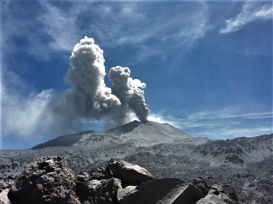
Peru , Sabancaya :
Analysis period: August 10-16, 2020, Arequipa, August 17, 2020
Alert level: ORANGE
The Geophysical Institute of Peru (IGP) reports that the eruptive activity of the Sabancaya volcano remains at moderate levels; that is to say with the continuous recording of explosions with columns up to 2.5 km high at the top of the volcano and the consequent emission of ash and gas. Therefore, for the following days, no significant change is expected in the eruptive activity.
The IGP recorded and analyzed the occurrence of 1021 earthquakes of volcanic origin, associated with the circulation of magmatic fluids inside the Sabancaya volcano. An average of 17 explosions was recorded daily of low to medium intensity.
During this period, the volcano-tectonic (VT) earthquakes were located mainly 12 km north of Sabancaya. The most significant seismic activity was recorded on August 14, represented in a swarm of earthquakes with magnitudes between M1.7 and M4.5. The largest earthquake, reported by the National Seismic Center (CENSIS), occurred at 3:34 p.m. at a depth of 13 km.
The monitoring of the deformation of the volcanic structure, using GNSS data (processed with fast orbits), does not present any significant anomalies; however, a slight inflation was recorded by the stations located in the northern sector of Hualca Hualca and on the south-eastern flank of the Sabancaya volcano. Visual surveillance identified columns of gas and ash up to 2.5 km high at the top of the volcano, which were scattered towards the southern, southeast and eastern sectors of Sabancaya. Satellite monitoring has identified the presence of 3 thermal anomalies with values between 2 MW and 4 MW, associated with the presence of a lava body on the surface of the volcano crater.
RECOMMENDATIONS
• Maintain the orange volcanic alert level.
• Do not approach within a radius of less than 12 km from the crater.
Source : IGP
Photo : Ingemmet.
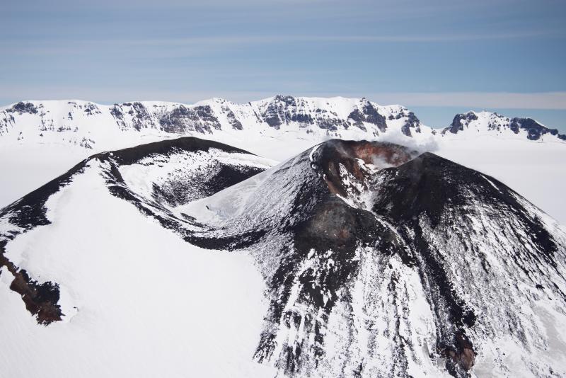
Alaska , Veniaminof :
AVO/USGS Volcanic Activity Notice
Current Volcano Alert Level: NORMAL
Previous Volcano Alert Level: ADVISORY
Current Aviation Color Code: GREEN
Previous Aviation Color Code: YELLOW
Issued: Thursday, August 20, 2020, 11:39 AM AKDT
Source: Alaska Volcano Observatory
Location: N 56 deg 11 min W 159 deg 23 min
Elevation: 8225 ft (2507 m)
Area: Alaska Peninsula
Volcanic Activity Summary:
Seismic tremor detected in June at Veniaminof has continued intermittently, but with decreasing frequency, and there have been no indications of surface change including increased temperatures or gas emissions. Tremor at Veniaminof in the past has sometimes preceded eruptions, but also can occur and persist for weeks to months and not result in an eruption. Current observations suggest activity has returned to near background, and thus the Aviation Color Code and the Volcano Alert Level are being decreased to GREEN/NORMAL.
The Alaska Volcano Observatory continues to closely monitor Veniaminof with local seismic sensors, satellite data, web cameras, and remote infrasound and lightning networks.
Recent Observations:
[Volcanic cloud height] None
[Other volcanic cloud information] n/a
Remarks: Mount Veniaminof volcano is an andesitic stratovolcano with an ice-filled 10-km diameter summit caldera located on the Alaska Peninsula, 775 km (480 mi) southwest of Anchorage and 35 km (22 mi) north of Perryville. Veniaminof is one of the largest (~300 cubic km; 77 cubic mi) and most active volcanic centers in the Aleutian Arc and has erupted at least 14 times in the past 200 years. Recent eruptions in 1993-95, 2005, 2013, and 2018 all occurred at the intracaldera cone and lasted for several months. These eruptions produced lava spattering and fountaining, minor emissions of ash and gas, and small lava flows into intracaldera icefield. Minor ash-producing explosions occurred nearly annually between 2002 and 2010. Previous historical eruptions have produced ash plumes that reached 15,000 to 20,000 ft above sea level (1939, 1956, and 2018) and ash fallout that blanketed areas within about 40 km (25 mi) of the volcano (1939, 2018).
Source : AVO.
Photo : Read, Cyrus , 11 Juillet 2018 .


No comment yet, add your voice below!