
January 14 , 2023 .
Indonesia , Merapi :
Report on the activity of Mount Merapi from January 06, 2023 to January 12, 2023, Published on January 13, 2023
RESULTS OF OBSERVATIONS
Visual
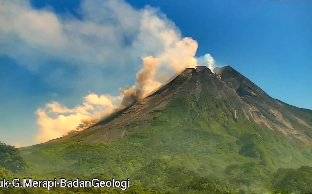
The weather around Mount Merapi is usually sunny in the morning and afternoon, while the evening is foggy. White smoke, thin to medium thickness, low pressure and 100 m high was observed from the Mount Merapi observation post in Selo on January 11, 2023 at 5:30 p.m. WIB.
This week there were 3 southwestward lava avalanches (first to Kali Bebeng then Kali Sat/Putih) with a maximum slip distance of 1200m. The sound of avalanches was heard from Pos Babadan 6 times with low to medium intensity
– There is no significant morphological change in the South-West dome and the central dome. The volume of the South-West dome is calculated fixed, i.e. 1,616,500 m3, while for the middle dome it is 2,772,000 m3.
Seismicity
This week, the seismicity of Mount Merapi showed:
17 deep volcanic earthquakes (VTB)
664 deep volcanic earthquakes (VTA),
261 avalanche earthquakes (RF),
1 emission earthquakes (DG),
10 tectonic earthquakes (TT).
75 multi-phase (MP) earthquakes
The intensity of this week’s seismicity is still quite high.
Deformation
The Mount Merapi deformation that was monitored using EDM and GPS this week showed a shortening rate of 0.6 cm/day.
Rain and lahars:
This week, there was rain at the Kaluirang observation post with a rain intensity of 32 mm/h for 100 minutes on January 10, 2023. No increase in flow is reported in the streams originating from the Merapi.
Conclusion
Based on the results of visual and instrumental observations, it is concluded that:
-The volcanic activity of Mount Merapi is still quite high in the form of effusive eruption activity. The state of the activity is defined at the « SIAGA » level.
Source : BPPTKG
Photo : Magma Indonésie
Alaska , Semisopochnoi :
51°55’44 » N 179°35’52 » E,
Summit Elevation 2625 ft (800 m)
Current Volcano Alert Level: WATCH
Current Aviation Color Code: ORANGE
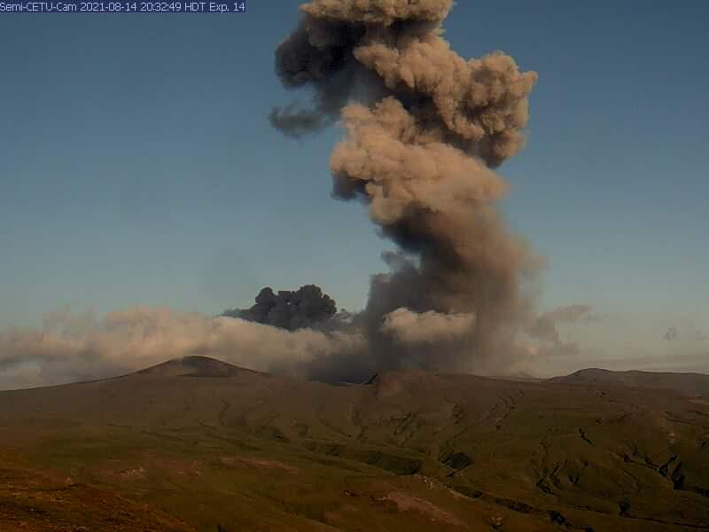
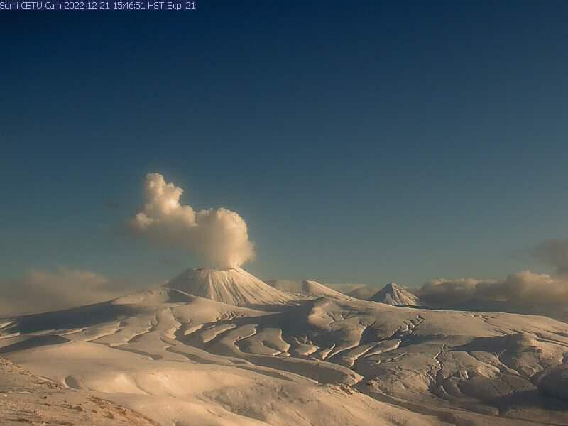
Activity continued this week at the north crater of Mount Young at Semisopochnoi Volcano. Seismicity was elevated throughout the week with small local earthquakes and weak tremor. Weak seismic and infrasound signals were recorded on Monday, but no ash emissions were observed in clear webcam views. However, a persistent steam plume from Mount Young, rising up to 5,000 ft above sea level, was observed all week when webcam views were clear. No eruptive activity was observed in satellite views.
The volcano has been erupting sporadically since 2018 and activity has been characterized by eruption of ash to heights usually less than 10,000 ft (3 km) above sea level.
Currently active Mount Cerberus volcano now named Mount Young
Semisopochnoi is a descriptive name derived from the Russian words “sem,” meaning “seven,” and “sopochka,” meaning “extinct volcano.” It was first used by G.A. Sarichev in 1826. Semisopochnoi Island is called « Uniyax » by the local indigenous Unangan people. Mount Cerberus was so named in 1935 by a U.S. Navy Survey Expedition « because the three connected summits comprising the volcano are analogous to the three-headed dog of Greek mythology, the guardian of the entrance to the underworld. »
A different Mount Cerberus, also a volcano, is located in the Katmai volcanic cluster in Katmai National Park and Preserve on the Alaska Peninsula. It was named in 1917 by R. F. Griggs of the National Geographic Society « descriptive of this mountain as being the (three-headed) watchdog guarding Hades (Valley of the Ten Thousand Smokes). »
With the renaming, Alaska is now home to a single Mount Cerberus.
The Don Young Recognition Act
The Act honors the legacy of the late Don Young, Alaskan Congressman and the Dean of the U.S. House of Representatives, who passed away in March 2022 after serving in the House for 49 years. In addition to Mount Young, the Act serves to rename the federal office building in Fairbanks as the Don Young Federal Office Building and the Job Corps Center located in Palmer as the Don Young Alaska Job Corps Center.
A state-of-the-art volcano monitoring network
Despite its remote location, Mount Young is monitored by a network of sensors including six seismometers, two web cameras, and three infrasound sensors on Semisopochnoi Island. Data from these instruments are telemetered in real-time to Amchitka Island to the south, and from there using a satellite uplink to the offices of the Alaska Volcano Observatory. This network allows AVO scientists to keep a close eye on unrest there, and to provide rapid warnings about renewed activity.
Source et photos : AVO
Kamchatka , Karymsky :
VOLCANO OBSERVATORY NOTICE FOR AVIATION (VONA)
Issued: January 12 , 2023
Volcano: Karymsky (CAVW #300130)
Current aviation colour code: GREEN
Previous aviation colour code: yellow
Source: KVERT
Notice Number: 2023-09
Volcano Location: N 54 deg 2 min E 159 deg 26 min
Area: Kamchatka, Russia
Summit Elevation: 1486 m (4874.08 ft)
Volcanic Activity Summary:
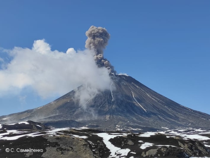
A moderate gas-steam activity of the volcano continues. Ash explosions of the volcano were noted last time on 07 August, 2022. The volcano is quiet at now. Only a weak thermal anomaly over the volcano accociated with its gas-steam activity is observing. KVERT continues to monitor Karymsky volcano.
A moderate gas-steam activity of the volcano continues. Ongoing activity could affect low-flying aircraft.
Volcanic cloud height: NO ASH CLOUD PRODUSED
Other volcanic cloud information: NO ASH CLOUD PRODUSED
Remarks:
Karymsky is one of the most active Kamchatkan volcanoes, and explosive and effusive-explosive eruptions of andesitic tephra and lava flows alternating with periods of repose are typical of them.
Source : Kvert.
Photo : S. Samoylenko ( archive)
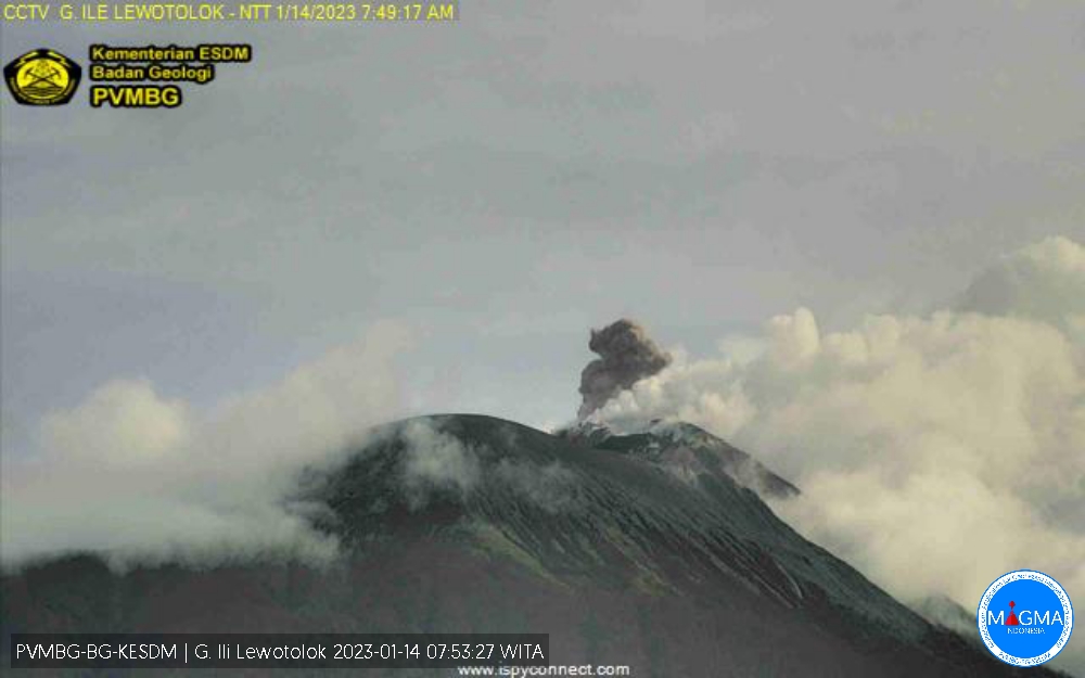
Indonesia , Ili Lewotolok :
An eruption of G. Ili Lewotolok occurred on Saturday, January 14, 2023, at 07:47 WITA. The height of the eruptive column was observed at ± 400 m above the summit (± 1823 m above sea level). The ash column was white to gray with moderate to thick intensity, oriented to the east. The eruption was recorded on a seismograph with a maximum amplitude of 8.6 mm and a duration of 35 seconds.
VOLCANO OBSERVATORY NOTICE FOR AVIATION – VONA
Issued : January 13 , 2023
Volcano : Ili Lewotolok (264230)
Current Aviation Colour Code : ORANGE
Previous Aviation Colour Code : unassigned
Source : Ili Lewotolok Volcano Observatory
Notice Number : 2023LEW001
Volcano Location : S 08 deg 16 min 19 sec E 123 deg 30 min 18 sec
Area : East Nusa Tenggara, Indonesia
Summit Elevation : 4554 FT (1423 M)
Volcanic Activity Summary :
éruption with volcanic ash cloud at 23h47 UTC (07h47 local).
Volcanic Cloud Height :
Best estimate of ash-cloud top is around 5834 FT (1823 M) above sea level or 1280 FT (400 M) above summit. May be higher than what can be observed clearly. Source of height data: ground observer.
Other Volcanic Cloud Information :
Ash cloud moving to east. Volcanic ash is observed to be white to gray. The intensity of volcanic ash is observed from medium to thick.
Remarks :
Eruption recorded on seismogram with maximum amplitude 8.6 mm and maximum duration 35 second.
Source et photo : Magma Indonésie.
Hawaii , Kilauea :
Friday, January 13, 2023, 8:48 AM HST (Friday, January 13, 2023, 18:48 UTC)
19°25’16 » N 155°17’13 » W,
Summit Elevation 4091 ft (1247 m)
Current Volcano Alert Level: WATCH
Current Aviation Color Code: ORANGE
Activity Summary:
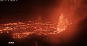
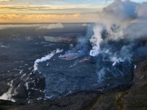
The summit eruption of Kīlauea Volcano, within Halemaʻumaʻu crater, continued over the past 24 hours. All recent eruptive activity has been confined to the crater. No significant changes have been observed at the summit or in either rift zone.
Halemaʻumaʻu Lava Lake Observations:
Eruption of lava from vents on the central eastern portion of Halemaʻumaʻu crater floor continued over the past 24 hours. Activity is concentrated in a large lava lake in the eastern half of the crater, as well as a smaller area of lava within the basin in the western half of the crater that was the focus of activity in 2021–2022. The active lava lake in the eastern half of the crater has one dominant fountain, measured at 6-7 yards (meters) high. The eastern lava lake had an area of approximately 30 acres (12 hectares) on January 10, and the surface area has fluctuated slightly over the past 24 hours.
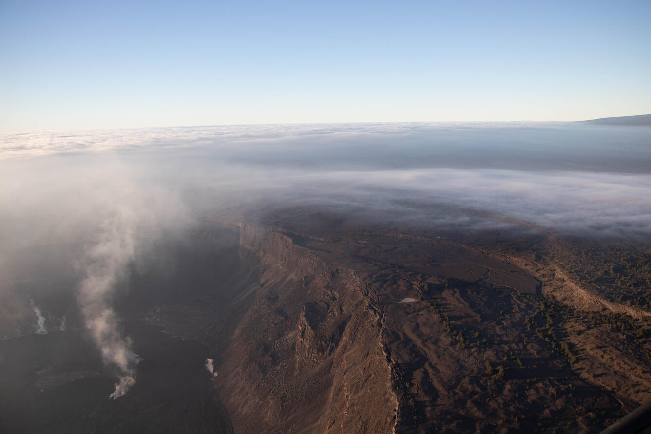
A plume emanates from the western side of Halema‘uma‘u crater, at the summit of Kīlauea, reaching the clouds of the inversion layer. The eruption within Halema‘uma‘u continues, with activity concentrated primarily in the eastern part of the crater (not shown) and a basin in the western part of the crater that was the focus of activity during the 2021-2022 eruption. Here, the western basin is characterized by some orange incandescence and a lighter gray color to the east (left) of the plume. Photo taken during an early morning overflight, with the view approximately southward.
Summit Observations:
Over the past 24 hours, summit tiltmeters showed no significant changes. Volcanic tremor remains above background levels. A sulfur dioxide (SO2) emission rate of approximately 3,500 tonnes per day (t/d) was measured on January 9, 2023.
Rift Zone Observations:
No unusual activity has been noted along the East Rift Zone or Southwest Rift Zone; low rates of ground deformation and seismicity continue along both. Measurements from continuous gas monitoring stations downwind of Puʻuʻōʻō in the middle East Rift Zone have been below detection limits for SO2, indicating that SO2 emissions from Puʻuʻōʻō are negligible.
Source : HVO
Photo : USGS / J.M. Chang.
Just finished reading your blog and I have to say, it was an undivided hoot. Your writing style is so engaging, I felt like I was on a wild goose chase with you. The picture you included were also a hoot, and I’m persuadedconvinced that you must have a photographic memory because they were so vivid. Keep it up, it’s a real trip! »
Wow…. Merci beaucoup.