March 17, 2022 . EN . Italy : Vulcano , Saint Vincent : Soufrière Saint Vincent , Japan : Asosan , Colombia : Cumbal , Ecuador : Wolf / Sangay , La Palma : Cumbre Vieja .

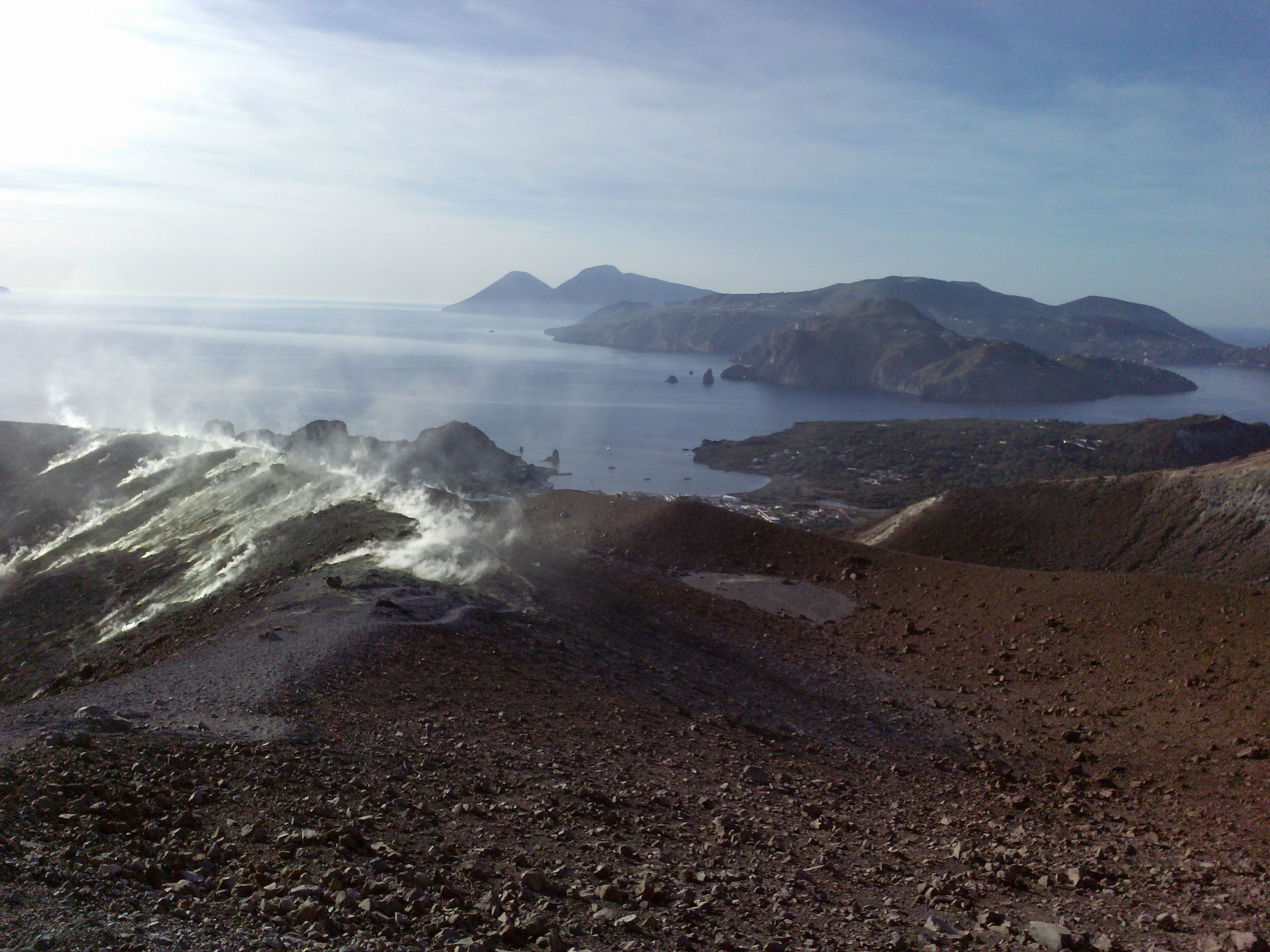
March 17 ,  2022 .


Italy , Vulcano :

WEEKLY NEWSLETTER, from March 07, 2022 to March 13, 2022. (issue date March 15, 2022)

SUMMARY OF STATUS OF ACTIVITY

In the light of the surveillance data, it is highlighted:

1) Temperature of the crater fumaroles: The updated data of the temperatures recorded on the edge of the crater show stable values ​​and confirm the continuation of the thermal anomaly. On the internal side the values ​​are always stable at 114°C.
2) CO2 flux in the crater area: The CO2 flux in the crater area remains at high values.
3) SO2 flux in the crater area: SO2 flux at a medium-high level and decreasing
4) Geochemistry of fumarolic gases: The concentrations of magmatic species (CO2, He) are decreasing and are at medium-high levels.
5) CO2 fluxes at the base of the La Fossa cone and in the Vulcano Porto area: The CO2 fluxes recorded in the Rimessa, C. Sicilia and P4max sites remain at medium-high values; in the Faraglione site, there are values ​​close to the background level.

6) Geochemistry of thermal aquifers: The physico-chemical parameters recorded in the wells of Camping Sicilia and Bambara do not show significant variations, remaining stable at high values.
7) Local seismicity: low occurrence rate of local events.
8) Regional seismicity: No earthquake with Ml >= 1.0 was located in the area of ​​the island of Vulcano.
9) Deformations – GNSS: The network of permanent GNSS stations has not recorded any significant changes.
10) Deformations – Inclinometry: The inclinometric network has not recorded any significant changes
11) Other observations: Gravimetry: During the period considered, no significant variation was recorded.
GB-RAR: GB-RAR monitoring results referring to the period December 14, 2021 – March 14, 2022, show general stability of the area, with deformations along the LOS of less than 1 mm.
Mobile GNSS: Mobile GNSS stations do not appear to show significant changes over the reporting period.

CRATER FUMAROLLES TEMPERATURE .
The reference sensor for the maximum temperature showed a weekly average of 385°C, with the maximum recorded value of 387°C. Locally, the sensor placed in the fumarole of the internal slope did not exceed 114.2°C, suggesting the presence of a liquid phase and a flow influenced by exogenous conditions.

CO2 FLOW IN THE CRATER AREA
The CO2 flux values on the ground in the summit zone on a daily average (VCSCS) show high values around 13,600 g/m2/day (value of March 13, 2022), still on an order of magnitude higher than the averages recorded in over the past 10 years.
The average value of the CO2 flux (monthly average) in March 2022 is 11055 g/m2/day. A stabilization of degassing at high values is therefore observed on a monthly scale. Data is updated as of March 13, 2022.

Source : INGV.

Read the article : https://www.ct.ingv.it/index.php/monitoraggio-e-sorveglianza/prodotti-del-monitoraggio/bollettini-settimanali-multidisciplinari/612-bollettino-settimanale-sul-monitoraggio-vulcanico-geochimico-e-sismico-del-vulcano-Vulcano-del-2022-03-15/file

Photos : INGV , G Vitton.


Saint Vincent , Soufrière Saint Vincent :

VOLCANO ALERT LEVEL IS LOWERED FROM YELLOW TO GREEN

The government of Saint Vincent and the Grenadines, on the advice of scientists at the University of the West Indies Seismic Research Center, has made the decision to lower the volcanic alert level from yellow to green, effective 16 March 2022. A GREEN alert means that the seismic and fumarolic activity (steam emission) of the La Soufrière volcano is at or below historic levels. No other unusual activity was observed.
The activity of the La Soufrière volcano is now considered to be at levels similar to the background activity recorded before the 2020-2021 eruption. The general downward trend in seismicity has continued over the past month.


No change in gas composition has been observed since the measurements were taken in late January. This indicates that the plume chemistry has returned to its pre-eruption chemistry. There has been no significant change in the deformation signal since May 2021.
The alert level was previously lowered from orange to yellow on September 15, 2021 and since then activities have either significantly decreased or ceased.
The La Soufrière trail remains closed due to uneven and dangerous terrain. The National Emergency Management Organization reminds the public of the potential threat to lahars (flood waters mixed with ash, other volcanic materials, mud, debris and rocks) after rainfall and the threat to people living and moving in the river valleys closest to the volcano.
Residents and motorists in areas near the volcano and people crossing rivers and streams during periods of heavy rainfall should always remain vigilant.
 
Source et photo : UWI Seismic Research Centre.


Japan , Asosan :

JMA reported that the amplitude of volcanic tremor signals at Asosan had decreased at around 1540 on 27 February and remained low. White plumes rose 600-800 m above the crater during 7-14 March. During field surveys conducted on 8 and 10 March sulfur dioxide gas emissions were 1,300 and 900 tons per day, respectively; these values were higher than those measured before the October 2021 eruption. No other changes were observed. JMA lowered the Alert Level to 2 (on a scale of 1-5) on 14 March and warned the public to stay at least 1 km away from the crater.

The 24-km-wide Asosan caldera was formed during four major explosive eruptions from 300,000 to 90,000 years ago. These produced voluminous pyroclastic flows that covered much of Kyushu. The last of these, the Aso-4 eruption, produced more than 600 km3 of airfall tephra and pyroclastic-flow deposits. A group of 17 central cones was constructed in the middle of the caldera, one of which, Nakadake, is one of Japan’s most active volcanoes. It was the location of Japan’s first documented historical eruption in 553 CE. The Nakadake complex has remained active throughout the Holocene. Several other cones have been active during the Holocene, including the Kometsuka scoria cone as recently as about 210 CE. Historical eruptions have largely consisted of basaltic to basaltic-andesite ash emission with periodic strombolian and phreatomagmatic activity. The summit crater of Nakadake is accessible by toll road and cable car, and is one of Kyushu’s most popular tourist destinations.

Sources : Agence météorologique japonaise (JMA) , GVP .

Photo : Nakadake , GVP.


Colombia , Cumbal :

Cumbal Volcanic Complex Weekly Activity Bulletin

The activity of the Cumbal Volcanic Complex continues at: YELLOW LEVEL  (III): CHANGES IN THE BEHAVIOR OF VOLCANIC ACTIVITY.

From monitoring the activity of the CUMBAL VOLCANIC COMPLEX (CVC), the COLOMBIAN GEOLOGICAL SERVICE (SGC) reports that:

In low levels and compared to the previous week, during the period between March 8 and March 14, 2022, an increase in the number of earthquakes and a decrease in the energy released were observed. Most of the earthquakes were of low energy, being located mainly southeast of La Plazuela crater at distances between 1.5 and 3 km with depths less than 1 km.

A few other earthquakes were scattered in the area of influence of the Cumbal Volcanic Complex, at distances of up to 13 km, at depths less than 14 km from the height of La Plazuela (4700 m above sea level). altitude) and with a maximum local magnitude of 1.0.
The favorable climatic conditions allowed the recording of the surface activity throughout the week evaluated, with columns of white gases, of low height and variable dispersion due to the action of the winds, emitted from the adventitious crater El Verde, northeast of the Cumbal Volcanic Complex and Los Rastrojos, Boca Vieja and other fumarolic fields of the active Mundo Nuevo cone southwest of the Cumbal Volcanic Complex. No significant variation was observed in the other geophysical and geochemical parameters of volcanic monitoring.

Source et photo : SGC.


Ecuador , Wolf / Sangay :

DAILY REPORT OF THE STATE OF WOLF VOLCANO. Wednesday March 16, 2022.

Surface Activity Level: High, Surface Trend: Unchanged
Internal activity level: High, Internal trend: No change

Seismicity: From March 15, 2022, 11:00 a.m. to March 16, 2022, 11:00 a.m.:
No seismic event has been recorded at the volcano in the past 24 hours.

Other Monitoring Parameters:
The FIRMS system recorded 81 thermal anomalies; Similarly, the MIROVA system recorded 2 strong thermal anomalies (1743 and 1373 MW) and 1 high (124 MW) during the last 24 hours.

Gas:
The MOUNTS system recorded 0.1 tons of SO2, on March 14 at 7:10 p.m. TL.

Observation:
Thanks to the images provided by the GOES-16 satellite, thermal anomalies can be observed due to the effect of advancing lava flows.

Alert level: Without alert.


                                                      ———————————————————————————————————————————————–


DAILY REPORT OF THE STATE OF SANGAY VOLCANO, Wednesday March 16, 2022.
Information Geophysical Institute – EPN.

Surface Activity Level: High, Surface Trend: No change.
Internal activity level: High, Internal trend: No change.

Seismicity: From March 15, 2022, 11:00 a.m. to March 16, 2022, 11:00 a.m.:
Explosion (EXP) 12
Long Periods (LP) 1
Emission Tremors (TREMI) 21

Rains / Lahars:
Thanks to the Windy satellite system, it was possible to verify the possible occurrence of rains in the volcano area. **In the event of heavy rains, these could remobilize the accumulated materials, generating mudslides and debris that would descend on the flanks of the volcano and flow into the adjacent rivers.**


Emission / ash column:
Yesterday afternoon, it was possible to observe a gas emission with a weak ash load, at 1 km altitude above the crater and heading towards the South-East. This morning, the Washington VAAC issued 2 reports of ash emission 870 meters above crater level and in a southwesterly direction.

Gas:
The MOUNTS system recorded 1462 tons of SO2 (March 15 at 2:05 p.m. TL).

Other Monitoring Parameters:
The FIRMS system recorded 31 thermal anomalies; the MIROVA system recorded 1 high thermal anomaly (193 MW) in the last 24 hours.

Alert level: Orange.                                                                                            

Source : IGEPN.

Photos : IGEPN


La Palma , Cumbre Vieja :

Post-eruption activity at Cumbre Vieja, La Palma, March 16, 2022, 09:00 UTC.

In the last 7 days, since the last communication (March 8 at 9:00 UTC), 27 earthquakes have been located on the island of La Palma. The magnitudes are between 0.9 and 2.3 (mbLg). Two of these earthquakes were weakly felt by the population, with a maximum intensity of II (EMS98). The location of hypocenters continues below the central area of Cumbre Vieja, in the same areas as in previous weeks, at depths between 0 and 16 km. No earthquake was located at greater depth.

The network of permanent GNSS stations on the island does not show significant deformations that could be associated with volcanic activity.

Seeing the earthquakes, I have a terrible suspicion that another magma reservoir is forming 7-8 km away. Something is happening there, just below the lava flow area between Tazacorte and Puerto Naos, and it shows that the earthquakes are positioned forming a circle. If I’m right, it won’t take long to pressurize and give more intense seismicity.
The truth is that the deformation to the East (LP05, MAZO and LP05) and South (LP04) of the island is increasing, indicating swelling, due to the contribution of magma at deep levels … the system there seems like he’s balancing himself out and getting ready for his reboot he hasn’t reached yet.
This is how it was described to me today what was perceptible in an area in the North of the Island: « A lot of wobble, up and down, very very strong and shocks, strong too. This will be balancing, I’m not saying no, … but it’s very strong Enrique.
And if we look at the release of the accumulated seismic energy released, we see the rebound from a few days ago and then how the system has relaxed…. we will see if it continues to relax in the next a few days or as it seems from the last symptoms that we have a new rebound. The volcano will tell us.

Sources : IGN es, Volcanes y Ciencia Hoy ( Henrique) .

Photo : I love the world.

17 Mars 2022 . FR. Italie : Vulcano , Saint Vincent : Soufrière Saint Vincent , Japon : Asosan , Colombie : Cumbal , Equateur : Wolf / Sangay , La Palma : Cumbre Vieja .

17 Mars 2022 .


Italie , Vulcano :

BULLETIN HEBDOMADAIRE, du 07 Mars 2022 au 13 Mars 2022. (date d’émission 15 Mars 2022)

SOMMAIRE DE L’ÉTAT D ‘ACTIVITÉ

À la lumière des données de surveillance, il est mis en évidence :

1) Température des fumerolles du cratère : Les données mises à jour des températures enregistrées sur le bord du cratère montrent des valeurs stables et confirment la poursuite de l’anomalie thermique. Du côté interne les valeurs sont toujours stables à 114°C.
2) Flux de CO2 dans la zone du cratère : Le flux de CO2 dans la zone du cratère reste sur des valeurs élevées.
3) Flux de SO2 dans la zone du cratère : flux de SO2 à un niveau moyen-élevé et en diminution
4) Géochimie des gaz fumeroliens : Les concentrations en espèces magmatiques (CO2, He) diminuent et se situent à des niveaux moyens-élevés.
5) Flux de CO2 à la base du cône de La Fossa et dans la zone de Vulcano Porto : Les flux de CO2 enregistrés dans les sites de Rimessa, C. Sicilia et P4max restent à des valeurs moyennes-élevées ; dans le site de Faraglione, il y a des valeurs proches du niveau de fond.

6) Géochimie des aquifères thermiques : Les paramètres physico-chimiques enregistrés dans les puits de Camping Sicilia et Bambara ne présentent pas de variations significatives, restant stables à des valeurs élevées.
7) Sismicité locale : faible taux d’occurrence d’événements locaux.
8) Sismicité régionale : Aucun séisme avec Ml > = 1,0 n’a été localisé dans la zone de l’île de Vulcano.
9) Déformations – GNSS : Le réseau de stations GNSS permanentes n’a pas enregistré de changements significatifs.
10) Déformations – Inclinométrie : Le réseau inclinométrique n’a pas enregistré de changements significatifs
11) Autres observations : Gravimétrie : Au cours de la période considérée, aucune variation significative n’a été enregistrée.
GB-RAR : Les résultats de la surveillance GB-RAR se référant à la période 14 décembre 2021 – 14 mars 2022, montrent une stabilité générale de la zone, avec des déformations le long de la LOS inférieures à 1 mm.
GNSS mobile : les stations GNSS mobiles ne semblent pas présenter de changements significatifs au cours de la période considérée.

TEMPÉRATURE DES FUMÉES DU CRATERE .
Le capteur de référence pour la température maximale a montré une moyenne hebdomadaire de 385 ° C, avec la valeur maximale enregistrée de 387 ° C. Localement, le capteur placé dans la fumerolle du talus interne n’a pas dépassé 114,2°C, suggérant la présence d’une phase liquide et d’un débit influencé par des conditions exogènes.

FLUX DE CO2 DANS LA ZONE DU CRATÈRE
Les valeurs de flux de CO2 au sol dans la zone sommitale en moyenne journalière (VCSCS) montrent des valeurs élevées autour de 13600 g/m2/jour (valeur du 13 mars 2022), toujours sur un ordre de grandeur supérieur à les moyennes enregistrées au cours des 10 dernières années.  
La valeur moyenne du flux de CO2 (moyenne mensuelle) en mars 2022 est de 11055 g/m2/jour. Une stabilisation du dégazage sur des valeurs élevées est donc observée à l’échelle mensuelle. Les données sont mises à jour au 13 mars 2022.

Source : INGV.

Lire l’article : https://www.ct.ingv.it/index.php/monitoraggio-e-sorveglianza/prodotti-del-monitoraggio/bollettini-settimanali-multidisciplinari/612-bollettino-settimanale-sul-monitoraggio-vulcanico-geochimico-e-sismico-del-vulcano-Vulcano-del-2022-03-15/file

Photos : INGV , G Vitton.


Saint Vincent , Soufrière Saint Vincent :

LE NIVEAU D’ALERTE DU VOLCAN EST ABAISSÉ DU JAUNE AU VERT
 
Le gouvernement de Saint-Vincent-et-les Grenadines, sur les conseils de scientifiques du Centre de recherche sismique de l’Université des Antilles, a pris la décision de baisser le niveau d’alerte volcanique de jaune au vert, à compter du 16 mars 2022. Une alerte VERTE signifie que l’activité sismique et fumerolienne (émission de vapeur) du volcan La Soufrière se situe au niveau historique ou en dessous. Aucune autre activité inhabituelle n’a été observée.
L’activité du volcan La Soufrière est désormais considérée comme étant à des niveaux semblables à l’activité de fond enregistrée avant l’éruption 2020-2021. La tendance générale à la baisse de la sismicité s’est poursuivie au cours du mois dernier.
 
 
Aucun changement dans la composition des gaz n’a été observé depuis que les mesures ont été prises à la fin janvier. Ceci indique que la chimie du panache est revenue à sa chimie de pré-éruption. Il n’y a pas eu de changement important dans le signal de déformation depuis mai 2021.
Le niveau d’alerte était précédemment abaissé de l’orange au jaune le 15 septembre 2021 et depuis, les activités ont considérablement diminué ou ont cessé.
Le sentier de La Soufrière reste fermé en raison du terrain inégal et dangereux. L’organisation nationale de gestion des urgences rappelle au public la menace potentielle pour les lahars (eaux d’inondation mélangées de cendres, d’autres matériaux volcaniques, de la boue, des débris et des roches) après les précipitations et la menace pour les personnes vivant et en mouvement dans les vallées fluviales au plus près du volcan.
Les résidents et les automobilistes dans les zones proches du volcan et les personnes traversant les rivières et les cours d’eau pendant les périodes de fortes précipitations devraient toujours rester vigilants.
 
Source et photo : UWI Seismic Research Centre.


Japon , Asosan :

Le JMA a signalé que l’amplitude des signaux de tremor volcanique sur l’ Asosan avait diminué vers 15 h 40 le 27 février et restait faible. Des panaches blancs se sont élevés de 600 à 800 m au-dessus du cratère du 7 au 14 mars. Au cours des enquêtes sur le terrain menées les 8 et 10 mars, les émissions de dioxyde de soufre étaient respectivement de 1 300 et 900 tonnes par jour ; ces valeurs étaient supérieures à celles mesurées avant l’éruption d’octobre 2021. Aucun autre changement n’a été observé. Le JMA a abaissé le niveau d’alerte à 2 (sur une échelle de 1 à 5) le 14 mars et a averti le public de rester à au moins 1 km du cratère.

La caldeira de l’Asosan, large de 24 km, s’est formée lors de quatre éruptions explosives majeures il y a 300 000 à 90 000 ans. Celles-ci ont produit des coulées pyroclastiques volumineuses qui ont couvert une grande partie de Kyushu. La dernière d’entre elles, l’éruption Aso-4, a produit plus de 600 km3 de dépôts de téphra et de coulées pyroclastiques. Un groupe de 17 cônes centraux a été construit au milieu de la caldeira, dont l’un, Nakadake, est l’un des volcans les plus actifs du Japon. C’était le lieu de la première éruption historique documentée du Japon en 553 de notre ère. Le complexe de Nakadake est resté actif tout au long de l’Holocène. Plusieurs autres cônes ont été actifs pendant l’Holocène, y compris le cône de scories de Kometsuka, récemment , aux  environs de 210 CE. Les éruptions historiques ont consisté en grande partie en une émission de cendres basaltiques à basaltiques-andésitique avec une activité strombolienne et phréato-magmatique périodique. Le cratère au sommet , Nakadake , est accessible par une route à péage et un téléphérique, et est l’une des destinations touristiques les plus populaires de Kyushu.

Sources : Agence météorologique japonaise (JMA) , GVP .

Photo : Nakadake , GVP.


Colombie , Cumbal :

Bulletin d’activité hebdomadaire du Complexe Volcanique de Cumbal

L’activité du Complexe Volcanique de Cumbal se poursuit au : NIVEAU JAUNE ■ (III) : CHANGEMENTS DANS LE COMPORTEMENT DE L’ACTIVITÉ VOLCANIQUE.

D’après le suivi de l’activité du COMPLEXE VOLCANIQUE DE CUMBAL (CVC), le SERVICE GÉOLOGIQUE COLOMBIEN (SGC) rapporte que :

Dans des niveaux bas et par rapport à la semaine précédente, durant la période comprise entre le 8 et le 14 mars 2022, une augmentation du nombre de séismes et une diminution de l’énergie libérée ont été observées. La plupart des tremblements de terre étaient de faible énergie, étant situés principalement au Sud-Est du cratère de La Plazuela à des distances comprises entre 1,5 et 3 km avec des profondeurs inférieures à 1 km.

 Quelques autres tremblements de terre ont été dispersés dans la zone d’influence du Complexe Volcanique de Cumbal, à des distances allant jusqu’à 13 km, à des profondeurs inférieures à 14 km par rapport à la hauteur de La Plazuela (4700 m d’altitude) et avec une magnitude locale maximale de 1,0.
Les conditions climatiques favorables ont permis l’enregistrement de l’activité de surface tout au long de la semaine évaluée, avec des colonnes de gaz blancs, de faible hauteur et de dispersion variable due à l’action des vents, émis depuis le cratère adventif El Verde, au Nord-Est du Complexe Volcanique de Cumbal et de Los Rastrojos, Boca Vieja et autres champs fumeroliens du cône actif de Mundo Nuevo au Sud-Ouest du Complexe Volcanique de Cumbal. Aucune variation significative n’a été observée dans les autres paramètres géophysiques et géochimiques de la surveillance volcanique.

Source et photo : SGC.


Equateur , Wolf / Sangay :

RAPPORT QUOTIDIEN DE L’ETAT DU VOLCAN WOLF . Mercredi 16 Mars 2022.

Niveau d’activité Superficiel: Haut , Tendance de surface : Sans changement
Niveau d’activité interne: Haut , Tendance interne : Sans changement

Sismicité : Du 15 Mars 2022 , 11:00h au 16 Mars 2022 , 11:00h : 
Aucun événement sismique n’a été enregistré sur le volcan au cours des dernières 24 heures.

Autres paramètres de surveillance :
Le système FIRMS a enregistré 81 anomalies thermiques ; De même, le système MIROVA a enregistré 2 anomalies thermiques fortes (1743 et 1373 MW) et 1 haute (124 MW) au cours des dernières 24 heures.

Gaz:
Le système MOUNTS a enregistré 0,1 tonne de SO2, le 14 mars à 19h10 TL.

Observation:
Grâce aux images fournies par le satellite GOES-16, des anomalies thermiques peuvent être observées dues à l’effet de l’avancée des coulées de laves.

Niveau d’alerte: Sans alerte.


                                                      ———————————————————————————————————————————————–


RAPPORT QUOTIDIEN DE L’ETAT DU VOLCAN SANGAY ,Mercredi 16 Mars 2022.
Information Geophysical Institute – EPN.

Niveau d’activité Superficiel: Haut , Tendance de surface : Pas de changement .
Niveau d’activité interne: Haut , Tendance interne : Pas de changement .

Sismicité : Du 15 Mars 2022 , 11:00h au 16 Mars 2022 , 11:00h : 
Explosion (EXP) 12
Longues périodes (LP) 1
Tremors d’émissions (TREMI) 21

Pluies / Lahars :
Grâce au système satellitaire Windy, il a été possible de vérifier l’éventuelle occurrence de pluies dans la zone du volcan. **En cas de fortes pluies, celles-ci pourraient remobiliser les matériaux accumulés, générant des coulées de boue et de débris qui descendraient sur les flancs du volcan et se déverseraient dans les rivières adjacentes.**


Émission / colonne de cendres :
Hier après-midi, il a été possible d’observer une émission de gaz avec une faible charge de cendres, à 1 km d’altitude au-dessus du cratère et se dirigeant vers le Sud-Est. Ce matin, le VAAC de Washington a émis 2 rapports d’émission de cendres à 870 mètres au-dessus du niveau du cratère et dans une direction Sud-Ouest.

Gaz:
Le système MOUNTS a enregistré 1462 tonnes de SO2 (le 15 mars à 14h05 TL).

Autres paramètres de surveillance :
Le système FIRMS a enregistré 31 anomalies thermiques ; le système MIROVA a enregistré 1 anomalie thermique élevée (193 MW) au cours des dernières 24 heures.

Niveau d’alerte: Orange.                                                                                                    

Source : IGEPN.

Photos : IGEPN


La Palma , Cumbre Vieja :

Activité post-éruptive sur Cumbre Vieja, La Palma, 16 Mars 2022 ,  09:00 UTC .

Au cours des 7 derniers jours, depuis la dernière communication (8 mars à 9h00 UTC), 27 tremblements de terre ont été localisés sur l’île de La Palma. Les magnitudes sont comprises entre 0,9 et 2,3 (mbLg). Deux de ces séismes ont été faiblement ressentis par la population, avec une intensité maximale de II (EMS98). La localisation des hypocentres se poursuit sous la zone centrale de Cumbre Vieja, dans les mêmes zones que les semaines précédentes, à des profondeurs comprises entre 0 et 16 km. Aucun séisme n’a été localisé à plus grande profondeur.

Le réseau de stations GNSS permanentes sur l’île ne montre pas de déformations importantes qui pourraient être associées à une activité volcanique.

En voyant les tremblements de terre, j’ai un terrible soupçon, qu’un autre réservoir de magma se forme à 7-8 km. Quelque chose se passe là-bas, juste en dessous de la zone de coulée de lave entre Tazacorte et Puerto Naos, et cela montre que les tremblements de terre sont positionnés formant un cercle . SI j’ai raison, il ne faudra pas longtemps pour pressuriser et donner une sismicité plus intense.
La vérité est que la déformation à l’Est (LP05, MAZO et LP05) et au Sud (LP04) de l’île est en augmentation, indiquant un gonflement, dû à la contribution du magma aux niveaux profonds … le système il semble qu’il s’équilibre et se prépare à son redémarrage qu’il n’a pas encore atteint.
C’est ainsi qu’il m’a été décrit aujourd’hui ce qui était perceptible dans une zone du Nord de l’Île : « Beaucoup de vacillement, de haut en bas, très très fort et de chocs, forts aussi. Ce sera de l’équilibrage, je suis ne dis pas non, … mais c’est très fort Enrique.
Et si on regarde la libération de l’énergie sismique accumulée libérée , on voit le rebond d’il y a quelques jours et puis comment le système s’est détendu…. on verra s’il continue à se détendre dans le prochain quelques jours ou comme il semble au vu des derniers symptômes que nous ayons un nouveau rebond. Le volcan nous le dira.

Sources : IGN es, Volcanes y Ciencia Hoy ( Henrique) .

Photo : I love the world.

March 14, 2022. EN. Hawaii : Mauna Loa , Alaska : Great Sitkin , Guatelama : Santiaguito , Costa Rica : Rincon de la Vieja / Turrialba / Poas / Irazu , Canary Islands / La Palma : Cumbre Vieja .

March 14 , 2022.


Hawaii , Mauna Loa :

19°28’30 » N 155°36’29 » W,
Summit Elevation 13681 ft (4170 m)
Current Volcano Alert Level: ADVISORY
Current Aviation Color Code: YELLOW

Activity Summary:
Mauna Loa volcano is not erupting. Rates of seismicity and CO2 concentrations at Sulphur Cone are slightly elevated above long-term background levels, but have not changed significantly over the past week. Other Mauna Loa monitoring data streams—ground deformation, all other gas concentrations, visual appearance in webcams—show no significant changes.

An early morning view looking north across Moku‘āweoweo, Mauna Loa’s summit caldera, from a spot near the summit cabin on the volcano’s south caldera rim. Frost covered much of the caldera floor that was still shadowed, and weak steaming issued from the usual areas. Overall, there were no significant changes observed at the summit. The 1940 and 1949 cones are visible in the sunlit area at left, and the gap that connects the caldera to South Pit is visible at the far left.

Observations:
During the past week, HVO seismometers recorded approximately 202 small-magnitude (below M2.5) earthquakes below Mauna Loa last week, 55 of which were under the summit and upper-elevation flanks. The majority of these earthquakes occurred at shallow depths less than 10 kilometers (6 miles) below sea level. Global Positioning System (GPS) measurements show very low rates of deformation in the summit region continuing through the past week.

Concentrations of sulfur dioxide (SO2) and hydrogen sulfide (H2S), as well as fumarole temperatures, remain stable at both the summit and at Sulphur Cone, on the upper Southwest Rift Zone. Concentrations of carbon dioxide (CO2) are also stable at the summit, but have slowly increased over the past year at Sulphur Cone. The CO2 measured concentrations remain low compared to many other volcanic areas globally.

Webcam views have shown no changes to the volcanic landscape on Mauna Loa over the past week.

Source : HVO.

Photo : M. Patrick, 09-08-2019.


Alaska , Great Sitkin :

52°4’35 » N 176°6’39 » W,
Summit Elevation 5709 ft (1740 m)
Current Volcano Alert Level: WATCH
Current Aviation Color Code: ORANGE

Slow lava effusion likely continues. Elevated surface temperatures were observed in satellite data, and robust steaming was observed in satellite and web camera images over the past day. These observations are consistent with continued slow effusion of lava. Seismicity remains low. It remains possible that explosive activity could occur with little or no warning.

Great Sitkin is monitored by local seismic and infrasound sensors, satellite data, web cameras, and remote infrasound and lightning networks.

Source : AVO

Photo : Loewen, Matt


Guatelama , Santiaguito :

Cloudy weather
Wind: North-East
Precipitation: 0.0 mm.

Activity:
The volcanic complex is completely covered with clouds, the seismic stations record prolonged and abundant periods of degassing coming from the crater and the lava flow which moves towards the West and the South-West, as well as weak avalanches which affected the southwest and west flanks. This causes fine ash particles to fall into the volcanic perimeter. Explosions, strong avalanches and audible sounds can be generated several kilometers from the volcanic edifice. Due to the permanent extrusion of lava in blocks in the Caliente dome, in a West-South-West direction, the occurrence of stronger avalanches of blocks and ash is not excluded, as well as possible pyroclastic flows over long distances in different directions. The recommendations of the special bulletin BESAN 003-2022 are still valid.

Source : Insivumeh.

Photo : La Hora


Costa Rica , Rincon de la Vieja / Turrialba / Poas / Irazu :

Volcanic Monitoring Program Weekly Bulletin, March 11, 2022.

Rincon de la Vieja Volcano
Latitude: 10.83°N;
Longitude: 85.324°W;
Altitude: 1895m
Current activity level: 3 (volcanic eruption)
Potentially associated dangers: Lahars, gas, phreatic and phreato-magmatic eruptions, proximal ballistic projections, acid rain, ashes.

The last phreatic eruption was recorded on February 20, 2022. A moderate energy explosion was recorded inside the volcano on March 9. Seismographs continue to record low amplitude volcanic tremors with frequencies between 2 and 4 Hz. Some earthquakes of the « tornillos » type (5 events), a distal earthquake of the VT type and a strong earthquake of type LP have been recorded. Geodetic observations do not show a significant deformation pattern. Residents of northern Rincón report a color change of Quebrada Azufrada from milky gray to bright orange. The color change is due to the deposition of an abundant quantity of ochre-orange iron oxides on the rocks and sediments of the creek bed induced by the marked decrease in precipitation and river flow.

Turrialba Volcano
Latitude: 10.025°N;
Longitude: 83.767°W;
Altitude: 3340m
Current activity level: 3 (volcanic eruption)
Potentially associated hazards: gas, ash emission, proximal ballistic projections, acid rain.

The last phreatic eruption occurred on February 28, since that date several rumblings have been recorded, some associated with small ash emissions. Seismic activity remains stable, the frequency of earthquakes has decreased again after showing an increase for several days. Many low and medium frequency LP type earthquakes are observed (about 250 LF and LPH events). Over the past 3 months, geodetic monitoring shows a more marked contraction of the Turrialba-Irazú massif around the active crater of Turrialba. The CO2/SO2 ratio shows some sporadic peaks. The weekly average for the CO2/SO2 ratio is 24.3 +/- 7.5, a similar value to the previous week, and for the H2S/SO2 ratio it is 0.26 +/- 0.11. The SO2 flow presented a peak at the beginning of the week and a decrease thereafter, it is estimated at 229 +/- 120 t/d. The SO2 analyzer at the Coronado Volcanic Gas and Aerosol Monitoring Station, EMVA/OVSICORI-UNA, recorded a maximum hourly average of 0.56 ppb SO2 over the past 24 hours, well below the regulatory limit value, which is an hourly average of 75 ppb SO2. On the other hand, the dust analyzer recorded a daily average of 6.8 ug/m3 of PM10, i.e. less than a tenth of the regulatory limit value, which averages 100 ug/m3 for 24 time. Data from the EMVA station indicate that the air quality in Coronado is good and that the levels of fumarolic emissions from the Turrialba and Poás volcanoes are negligible.

Poas Volcano
Latitude: 10.2°N;
Longitude: 84.233°W;
Altitude: 2780m
Current activity level: 2 (quiet active volcano)
Potentially associated dangers: gas, phreatic eruptions, proximal ballistic projections, acid rain, lahars.

No eruption has been detected so far in 2022. Seismicity remains stable, a proximal VT type earthquake was recorded on March 11. The geodetic network shows the stability of the volcanic edifice over the past 4 months. The weekly average of the SO2/CO2 ratio is 0.58 +/- 0.09 and H2S/SO2 remains stable with a value <0.012. The SO2 concentration around the crater was low during the week (<2 ppm SO2 at El Mirador). The flow of SO2 decreased a little (80 +/- 30 t/d). The level of the hyper-acidic lake has risen about 40 cm. The lake waters remain rich in chloride ion compared to sulfate ion, however, the composition of the lake shows a gradual trend towards waters with less chloride but with stable relative proportions of chloride and sulfate.

Irazu Volcano
Latitude: 9.979°N;
Longitude: 83.852°W;
Altitude: 3432m
Current activity level: 1 (quiet active volcano)
Potentially associated hazards: landslides, lahars, proximal ballistic projections, gas, acid rain, ash fall, debris avalanches.

The March 3 GPS measurement campaign on the main landslide in the Las Torres sector shows a stable trend except in the part west of the main fissure where a vertical acceleration is observed. Remember that the part near the edge of the cliffs remains very unstable and can collapse without warning. Geochemical gas monitoring in the fumarolic field in the northern sector of the volcano indicates that degassing remains light with concentrations of ~500 ppm CO2 and CO2/H2S ratios of ~350 +/- 304.

Source : Ovsicori.

Photos : Chris Allen, Javier Elizondo ( 2019) , Ovsicori , Herediahoy.com.


Canary Islands / La Palma , Cumbre Vieja :

Why does seismic activity continue on Cumbre Vieja?

The seismicity associated with active volcanoes can have different origins. On Cumbre Vieja, the seismicity recorded during the week preceding the eruption was mainly related to the rise of magma towards the surface. On the contrary, during the eruption, the intense seismicity observed was caused by the readjustment of the rocks located around the magmatic reservoirs which were gradually emptying. Once the eruption is over, there is daily seismicity characterized by a few dozen earthquakes, the magnitude of which is generally less than 2.

 
After the eruption was over, the volcanic tremor, that is, the strong roar of the volcano caused by its Strombolian explosive activity, suddenly disappeared. The disappearance of the volcanic tremor currently makes it possible to detect events of very small magnitude. However, many of these events are not earthquakes but events known as long-period events. This type of seismic event is usually caused by the movement of hydrothermal fluids in fractures of rocks in the basement of a volcano. Currently, the Cumbre Vieja volcano is recording very active seismicity with dozens of long-period type events detected every hour. Some of them are strong enough to be detected over almost the entire seismic network, being at depths less than 10 km. However, most of them are so small to be detected only up to 1-2 km from the newly formed volcanic building.
 
The long period type events on the Cumbre Vieja volcano are linked to the ongoing degassing process on the volcano and are due to the cooling of the magma still present in the magma reservoir. The cooling of the magma gradually releases the gases it had dissolved. Thus, the seismicity that continues to be observed on the Cumbre Vieja volcano has as its main origin the movement of hydrothermal fluids (gas, water and steam) released by the magma chamber at depth during their ascent to the surface.
For a better characterization of this seismicity of such small magnitude, an INVOLCAN team installed during the last week a temporary seismic network around the volcanic building. The figure above shows the hundreds of long-period events recorded in a few hours, many of which are of a magnitude small enough to be less than zero.

Source : Involcan.

Photos : I love the world , Involcan.

March 10 , 2022. EN. Indonesia : Merapi , Japan : Shinmoedake , Italy : Vulcano , Guatemala : Fuego , La Palma : Cumbre Vieja .

March 10 , 2022.


Indonesia , Merapi :

VOLCANO OBSERVATORY NOTICE FOR AVIATION – VONA

Issued : February 09 , 2022
Volcano : Merapi (263250)
Current Aviation Colour Code : RED
Previous Aviation Colour Code : unassigned
Source : Merapi Volcano Observatory
Notice Number : 2022MER01
Volcano Location : S 07 deg 32 min 31 sec E 110 deg 26 min 31 sec
Area : Special Region of Yogyakarta, Indonesia
Summit Elevation : 9498 FT (2968 M)

Volcanic Activity Summary :
Eruption with volcanic ash cloud at 16h18 UTC (23h18 local). Eruption and ash emission is continuing

Volcanic Cloud Height :
Best estimate of ash-cloud top is around 19098 FT (5968 M) above sea level, may be higher than what can be observed clearly. Source of height data: ground observer.

Other Volcanic Cloud Information :
Ash cloud moving to the southeast.

Remarks :
PDC moving to the southeast, wind direction to the west.

The Merapi avalanche hot cloud of March 10, 2022 at 7:33 a.m. WIB was recorded on a seismogram with an amplitude of 55 mm and a duration of 172 seconds. The slip distance is ±2,000 m to the southeast (Kali Gendol).

The Merapi erupted overnight, sending hot lava and ash down its slopes and prompting more than 250 nearby residents to evacuate, the country’s disaster mitigation agency (BNPB) said on Thursday.

The BNPB said 253 residents around the volcano in Indonesia’s Yogyakarta province were evacuated, while ash blanketed some villages. No casualties were immediately reported.

The agency said the last hot cloud was sent over the southeast slope of the volcano at 7:33 a.m. local time on Thursday.

Sources : Magma Indonésie , PVMBG , nst.com.my.

Photo : Oystein Lund Andersen.


Japan , Shinmoedake :

JMA reported an increase in volcanic earthquakes just below Shinmoedake (Shinmoe peak, a stratovolcano of the Kirishimayama volcano group). A total of 17 events were recorded during 1-2 March, prompting JMA to raise the Alert Level to 2 (on a scale of 1-5) on 2 March. No changes were seen at the volcano during a field visit that same day. Volcanic earthquakes persisted, with 5-12 events per day recorded through 7 March. Emissions had risen no higher than 30 m above the crater rim since 1 January, and fumarolic plumes continued to rise no higher than 100 m from a fissure on the W flank. During a field survey conducted on 4 March at the base of the volcano, sulfur dioxide emissions were below the detectable limit and no changes to area hot springs were observed.

Kirishimayama is a large group of more than 20 Quaternary volcanoes located north of Kagoshima Bay. The late-Pleistocene to Holocene dominantly andesitic group consists of stratovolcanoes, pyroclastic cones, maars, and underlying shield volcanoes located over an area of 20 x 30 km. The larger stratovolcanoes are scattered throughout the field, with the centrally located Karakunidake being the highest. Onamiike and Miike, the two largest maars, are located SW of Karakunidake and at its far eastern end, respectively. Holocene eruptions have been concentrated along an E-W line of vents from Miike to Ohachi, and at Shinmoedake to the NE. Frequent small-to-moderate explosive eruptions have been recorded since the 8th century.

Sources : GVP , Japan Meteorological Agency (JMA).

Photo : S. Nakano 08.03.2011 / Geological survey of Japan


Italy , Vulcano :

WEEKLY BULLETIN, from February 28, 2022 to March 06, 2022. (issue date March 08, 2022)

ACTIVITY STATUS SUMMARY.

In the light of the surveillance data, it is highlighted:

1) Temperature of the crater fumaroles: The updated data of the temperatures recorded on the edge of the crater show stable values and confirm the continuation of the thermal anomaly. On the internal side, the values are always stable at 114°C.
2) CO2 flux in the crater area: The CO2 flux in the crater area remains at high values.
3) SO2 flux in the crater area: SO2 flux at a medium-high level and decreasing
4) Geochemistry of fumarolic gases: No update is available concerning the geochemistry of fumarolic gases.

5) CO2 fluxes at the base of the La Fossa cone and in the Vulcano Porto area: The CO2 fluxes recorded in the Rimessa, C. Sicilia and P4max sites remain at medium-high values; in the Faraglione site, there are values ​​close to the background level.
6) Geochemistry of thermal aquifers: The physico-chemical parameters recorded in the wells of Camping Sicilia and Bambara remain stable at high values, although showing a very slight downward trend.
7) Local seismicity: Low rate of occurrence of local micro-shocks. Modest increase in the rate of occurrence of VLP-like events.
8) Regional seismicity: Low level fracturing seismicity: 1 single earthquake with Ml = 1.1
9) Deformations – GNSS: The network of permanent GNSS stations has not recorded any significant changes.
10) Deformations – Inclinometry: The inclinometric network has not recorded any significant changes
11) Other observations: Gravimetry: During the period considered, no significant variation was recorded.
Mobile GNSS: Mobile GNSS stations do not appear to show significant changes over the reporting period.
GB-RAR: The GB-RAR monitoring results referring to the period December 14, 2021 – March 07, 2022, show a general stability of the area, with deformations along the LOS of less than 1 mm.


TEMPERATURE OF THE FUMAROLES OF THE CRATER:
The reference sensor for the maximum temperature showed a weak upward trend; the weekly average is 385°C, with a maximum recorded heat of 388°C. Not far from T1, the T2 sensor instead showed a decreasing trend and larger disturbances of exogenous origin.
Locally, the sensor placed in the fumarole of the internal slope did not exceed 114.2°C, suggesting the presence of a liquid phase and a flow influenced by exogenous conditions.

CO2 FLOW IN THE CRATER AREA
The soil CO2 flux values ​​in the summit zone on a daily average (VCSCS) show high values ​​around 9413 g/m2/day (value of March 05, 2022), still on an order of magnitude higher than the averages recorded in over the past 10 years.
The average value of the CO2 flux (monthly average) in the month of February 2022 is 10875 g/m2/day. Thus, on a monthly scale, we observe a stabilization of degassing at high values, with a slight decrease compared to the previous month (January: 13425 g/m2/day).
The data is updated on March 05, 2022.

Source : INGV.

Read the article: https://www.ct.ingv.it/index.php/monitoraggio-e-sorveglianza/prodotti-del-monitoraggio/bollettini-settimanali-multidisciplinari/610-bollettino-settimanale-sul-monitoraggio-vulcanico-geochimico-e-sismico-del-vulcano-Vulcano-del-2022-03-08/file

Photos : INGV , Filippo Parisi .


Guatemala , Fuego :

SPECIAL VOLCANOLOGICAL BULLETIN, March 9, 2022, 3:15 p.m. local time

In the follow-up of the BEFGO bulletin # 013-2022 and on the basis of the instrumental parameters and the field monitoring carried out during the last hours, explosions of weak, moderate and strong characteristics are recorded with abundant ash emissions which move towards the West and the Southwest. These continue to generate weak to moderate avalanches towards the ravines of Ceniza, Trinidad and Las Lajas. In the crater, degassing and incandescence continue to be observed overnight and early in the morning.

No active lava flow is observed. The analysis of satellite images and field monitoring carried out by the staff of the Fuego Volcano Observatory OVFGO, has confirmed that the area affected by the recent pyroclastic flows includes a radius of 7 km around the crater towards the south. -West, South and Southeast, where vegetation and crops affected by high temperature gas and ash clouds are also confirmed. In addition, a large amount of ash falls on the vegetation, the roofs of the houses and the streets of the communities. These ashes can be carried by the wind and remain suspended at low levels in the air, creating a foggy environment for several hours which can be detrimental to the health of people. In the presence of rain, lahars can be generated in all the ravines of the volcano, but they are expected to be more recurrent and more important in the ravines of El Jute, Las Lajas, Ceniza and Trinidad.

It is not excluded that new lava flows will be generated towards other ravines, as well as violent ash-laden explosions and avalanches of moderate characteristics towards one of the ravines of the Fuego volcano, which is why we should not not stay near or in the ravines of the volcano. INSIVUMEH maintains visual and instrumental monitoring of volcanic activity through seismic stations, volcano spotters and web cameras.

Source : Insivumeh.

Photo : Diego Rizzo .


La Palma , Cumbre Vieja :

Post-eruption activity on Cumbre Vieja, La Palma. 09 March 2022, 09:00 UTC
In the last 7 days, since the last communication (March 1 at 9:00 UTC), 64 earthquakes have been located on the island of La Palma. The magnitudes are between 0.7 and 2.5 (mbLg). Three of these earthquakes were weakly felt by the population, with a maximum intensity of II (EMS98). The location of hypocenters continues below the central area of Cumbre Vieja, in the same areas as in previous weeks, at depths between 0 and 18 km. Only two earthquakes of this period, of magnitudes 1.9 and 1.5 mbLg, were located at greater depths (24 and 30 km), respectively.
The network of permanent GNSS stations on the island does not show significant deformations that could be associated with volcanic activity.

The curve of the accumulated seismic energy released shows a small rise from about 4-5 days ago towards the reservoir at 10-14 km, mainly by the gases which followed their way to the surface through the closed conduit, this could be the reason for an increase in the rate of gas emission from the volcanic cone. In fact, there was a little pressurization in the final area of ​​the conduit between 1 and 6 km, mostly from gases or steam, possibly due to water entering the hot areas of the conduits . This certainly caused the deformation yesterday at stations LP03 and LP04 with a swelling of 3-4 cm and some earthquakes in the conduit, highlighting a 2.1 to 6 km in the conduit area this morning that was felt.

Volcanic activity in the Canary Islands:
Throughout the month of February, a total of 273 earthquakes were located in the Canary Islands region, with a maximum magnitude of 3.7 mbLg in the earthquake located on the 19th at 21:22 (UTC), between the islands of Tenerife and Gran Canaria, at a depth of 13 km and which was felt with intensity II (EMS98) in many populations of the two islands.

On the 8th, at 11:54 a.m. (UTC), an earthquake of magnitude 3.3 (mbLg) was located, with an epicenter on the southwest coast of Fuerteventura, felt with intensity II (EMS98) in the towns of La Pared, Majorera. , Toto and Valley of Santa Inés. Further west, between the islands of Fuerteventura and Gran Canaria, this month 13 earthquakes were located, between magnitudes 1.4 and 3.3 (mbLg) and depths between 0 and 41 km . On the coast of Mogan, west of Gran Canaria, on the 19th, an earthquake of magnitude 2.2 (mbLg) and depth of 2 km was located, which was weakly felt with intensity II (EMS98 ) in the city of Maspalomas.


Between the islands of Gran Canaria and Tenerife, 35 earthquakes were located during this period, with magnitudes between 0.7 and 3.7 mbLg and depths between 0 and 44 km. In the interior of the island of Tenerife, the seismic activity was located mainly in the areas near Adeje, Vilaflor de Chasna and Fasnia, with a total of 46 earthquakes located between magnitudes 0.0 and 2 .2 (mbLg) and depths between 1 and 34 km.

In the volcanic process that is developing on the island of La Palma, which began last September 19 and of which we have been in a post-eruptive phase since December 13 at 22:21 (UTC), 163 earthquakes have been located , with magnitudes between 0.2 and 2.5 (mbLg) and depths between 0 and 37 km. In total, 4 of these earthquakes were felt weakly by the population of the island of La Palma, with a maximum intensity of II-III (EMS98).

In the area of ​​El Hierro Island, 3 earthquakes between magnitudes 1.9 and 3.0 (mbLg) and depths between 19 and 36 km were located.

The analyzes of the data obtained at the control points of the geochemical monitoring network of the island of La Palma indicate that, throughout the month of February, variations were detected both in the emission of radon and thoron and in the concentrations and isotopic ratios of helium and carbon from dissolved gases, directly related to the evolution of the post-eruptive process.

The results obtained from the observations made by the Permanent GNSS Stations of the Volcanic Surveillance Network, the InSAR processing and the signal from the inclinometer do not show any significant deformation on any of the islands.

Sources : IGN es , Volcanes y Ciencia Hoy .

Photo : I love the world.

10 Mars 2022. FR. Indonésie : Merapi , Japon : Shinmoedake , Italie : Vulcano , Guatemala : Fuego , La Palma : Cumbre Vieja .

10 Mars 2022.


Indonésie , Merapi :

AVIS D’OBSERVATION DU VOLCAN POUR L’AVIATION – VONA

Émis : 10 Mars 2022
Volcan : Mérapi (263250)
Code Couleur Aviation Actuel : ROUGE
Code couleur aviation précédent : non attribué
Source : Observatoire du volcan Merapi
Numéro d’avis : 2022MER01
Emplacement du volcan : S 07 deg 32 min 31 sec E 110 deg 26 min 31 sec
Région : Région spéciale de Yogyakarta, Indonésie
Altitude du sommet : 9498 FT (2968 M)

Résumé de l’activité volcanique :
Eruption avec nuage de cendres volcaniques à 16h18 UTC (23h18 locale). L’éruption et l’émission de cendres se poursuivent

Hauteur des nuages volcaniques :
La meilleure estimation du sommet du nuage de cendres est d’environ 19098 FT (5968 M) au-dessus du niveau de la mer, peut être plus élevée que ce qui peut être observé clairement. Source des données de hauteur : observateur au sol.

Autres informations sur les nuages volcaniques :
Nuage de cendres se déplaçant vers le Sud-Est.

Remarques :
Nuage chaud d’avalanche se déplaçant vers le Sud-Est, direction du vent vers l’Ouest.

Le nuage chaud d’avalanche du Merapi du 10 mars 2022 à 7h33 WIB a été enregistré sur un sismogramme avec une amplitude de 55 mm et une durée de 172 secondes. La distance de glissement est de ±2 000 m vers le Sud-Est (Kali Gendol).  

Le Merapi est entré en éruption pendant la nuit, envoyant de la lave chaude et des cendres sur ses pentes et incitant plus de 250 habitants des environs à évacuer, a annoncé jeudi l’agence d’atténuation des catastrophes du pays (BNPB).

Le BNPB a déclaré que 253 habitants autour du volcan dans la province indonésienne de Yogyakarta ont été évacués, tandis que des cendres recouvraient certains villages. Aucune victime n’a été signalée dans l’immédiat.

L’agence a déclaré que le dernier nuage chaud avait été envoyé sur le versant Sud-Est du volcan à 7h33.m heure locale jeudi.

Sources : Magma Indonésie , PVMBG , nst.com.my.

Photo : Oystein Lund Andersen.


Japon , Shinmoedake :

Le JMA a signalé une augmentation des tremblements de terre volcaniques juste en dessous du Shinmoedake (pic Shinmoe, un stratovolcan du groupe de volcans Kirishimayama). Au total, 17 événements ont été enregistrés du 1er au 2 mars, ce qui a incité le JMA à relever le niveau d’alerte à 2 (sur une échelle de 1 à 5) le 2 mars. Aucun changement n’a été observé sur le volcan lors d’une visite sur le terrain le même jour. Les tremblements de terre volcaniques ont persisté, avec 5 à 12 événements par jour enregistrés jusqu’au 7 mars. Les émissions n’avaient pas augmenté de plus de 30 m au-dessus du bord du cratère depuis le 1er janvier, et les panaches fumeroliens ont continué à s’élever à moins de 100 m d’une fissure sur le flanc Ouest. Lors d’une enquête sur le terrain menée le 4 mars à la base du volcan, les émissions de dioxyde de soufre étaient inférieures à la limite détectable et aucun changement dans les sources chaudes de la région n’a été observé.

Kirishimayama est un grand groupe de plus de 20 volcans quaternaires situés au Nord de la baie de Kagoshima. Le groupe principalement de nature andésitique datant du Pléistocène tardif à l’Holocène se compose de stratovolcans, de cônes pyroclastiques, de maars et de volcans boucliers sous-jacents situés sur une superficie de 20 x 30 km. Les plus grands stratovolcans sont dispersés dans tout le champ, le Karakunidake situé au centre étant le plus élevé. Onamiike et Miike, les deux plus grands maars, sont situés au Sud-Ouest du Karakunidake et à son extrémité extrême-Est, respectivement. Les éruptions de l’Holocène ont été concentrées le long d’une ligne orientée Est-Ouets d’évents de Miike à Ohachi, et au Shinmoedake au Nord-Est. De fréquentes éruptions explosives petites à modérées ont été enregistrées depuis le 8ème siècle.

Sources : GVP , Japan Meteorological Agency (JMA).

Photo : S. Nakano 08.03.2011 / Geological survey of Japan


Italie , Vulcano :

BULLETIN HEBDOMADAIRE, du 28 Février 2022 au 06 Mars 2022. (date d’émission 08 Mars 2022)

SOMMAIRE DE L’ÉTAT DE L’ACTIVITÉ.

À la lumière des données de surveillance, il est mis en évidence :

1) Température des fumerolles du cratère : Les données mises à jour des températures enregistrées sur le bord du cratère montrent des valeurs stables et confirment la poursuite de l’anomalie thermique. Côté interne, les valeurs sont toujours stables à 114°C.
2) Flux de CO2 dans la zone du cratère : Le flux de CO2 dans la zone du cratère reste sur des valeurs élevées.
3) Flux de SO2 dans la zone du cratère : flux de SO2 à un niveau moyen-élevé et en diminution
4) Géochimie des gaz fumeroliens : Aucune mise à jour n’est disponible concernant la géochimie des gaz fumeroliens.

5) Flux de CO2 à la base du cône de La Fossa et dans la zone de Vulcano Porto : Les flux de CO2 enregistrés dans les sites de Rimessa, C. Sicilia et P4max restent à des valeurs moyennes-élevées ; dans le site de Faraglione, il y a des valeurs proches du niveau de fond.
6) Géochimie des aquifères thermiques : Les paramètres physico-chimiques enregistrés dans les puits de Camping Sicilia et Bambara restent stables à des valeurs élevées, bien que présentant une très légère tendance à la baisse.
7) Sismicité locale : Faible taux d’occurrence de micro-chocs locaux. Augmentation modeste du taux d’occurrence des événements de type VLP.
8) Sismicité régionale : Sismicité de fracturation de faible niveau : 1 seul séisme avec Ml = 1,1
9) Déformations – GNSS : Le réseau de stations GNSS permanentes n’a pas enregistré de changements significatifs.
10) Déformations – Inclinométrie : Le réseau inclinométrique n’a pas enregistré de changements significatifs
11) Autres observations : Gravimétrie : Au cours de la période considérée, aucune variation significative n’a été enregistrée.
GNSS mobile : les stations GNSS mobiles ne semblent pas présenter de changements significatifs au cours de la période considérée.
GB-RAR : Les résultats de la surveillance GB-RAR se référant à la période 14 décembre 2021 – 07 mars 2022, montrent une stabilité générale de la zone, avec des déformations le long de la LOS inférieures à 1 mm.


TEMPÉRATURE DES FUMEROLLES DU CRATERE :
Le capteur de référence pour la température maximale a montré une faible tendance à la hausse ; la moyenne hebdomadaire est de 385°C, avec une chaleur maximale enregistrée de 388°C. Non loin de T1, le capteur T2 a plutôt montré une tendance à la baisse et des perturbations plus importantes d’origine exogène  .
Localement, le capteur placé dans la fumerolle du talus interne n’a pas dépassé 114,2°C, suggérant la présence d’une phase liquide et d’un débit influencé par des conditions exogènes.

FLUX DE CO2 DANS LA ZONE DU CRATERE
Les valeurs de flux de CO2 du sol dans la zone sommitale en moyenne journalière (VCSCS) montrent des valeurs élevées autour de 9413 g/m2/jour (valeur du 05 mars 2022), toujours sur un ordre de grandeur supérieur à la moyennes enregistrées au cours des 10 dernières années.
La valeur moyenne du flux de CO2 (moyenne mensuelle) au mois de février 2022 est de 10875 g/m2/jour. Ainsi, à l’échelle mensuelle, on observe une stabilisation du dégazage sur des valeurs élevées, avec une légère baisse par rapport au mois précédent (janvier : 13425 g/m2/jour).
Les données sont mises à jour le 05 mars 2022.

Source : INGV.

Lire l’article https://www.ct.ingv.it/index.php/monitoraggio-e-sorveglianza/prodotti-del-monitoraggio/bollettini-settimanali-multidisciplinari/610-bollettino-settimanale-sul-monitoraggio-vulcanico-geochimico-e-sismico-del-vulcano-Vulcano-del-2022-03-08/file

Photos : INGV , Filippo Parisi .


Guatemala , Fuego :

BULLETIN SPECIAL VOLCANOLOGIQUE, 9 mars 2022, 15h15 heure locale

Dans le suivi du bulletin BEFGO # 013-2022 et sur la base des paramètres instrumentaux et des suivis de terrain effectués au cours des dernières heures, des explosions de caractéristiques faibles, modérées et fortes sont enregistrées avec des émissions de cendres abondantes qui se déplacent vers l’Ouest et le Sud-Ouest. Celles-ci continuent à générer des avalanches faibles à modérées vers les ravins de Ceniza, Trinidad et Las Lajas. Dans le cratère, le dégazage et l’incandescence continuent d’être observés pendant la nuit et tôt le matin.

Aucune coulée de lave active n’est observée. L’analyse des images satellites et la surveillance de terrain effectuée par le personnel de l’Observatoire du volcan Fuego OVFGO, a permis de confirmer que la zone affectée par les récentes coulées pyroclastiques comprend un rayon de 7 km autour du cratère en direction du Sud-Ouest, du Sud et du Sud-Est, où la végétation et les cultures affectées par des nuages ​​de gaz et de cendres à haute température sont également confirmées. De plus, une grande quantité de cendres tombe sur la végétation, les toits des maisons et les rues des communautés. Ces cendres peuvent être emportées par le vent et rester en suspension à de faibles niveaux dans l’air, créant un environnement brumeux pendant plusieurs heures qui peut être préjudiciable à la santé des personnes. En présence de pluie, des lahars peuvent être générés dans tous les ravins du volcan, mais on s’attend à ce qu’ils soient plus récurrents et plus importants dans les ravins d’El Jute, Las Lajas, Ceniza et Trinidad.

Il n’est pas exclu que de nouvelles coulées de lave soient générées vers d’autres ravins, ainsi que de violentes explosions chargées de cendres et des avalanches de caractéristiques modérées vers l’un des ravins du volcan Fuego, raison pour laquelle il ne faut pas rester à proximité ou dans le ravins du volcan . L’INSIVUMEH maintient une surveillance visuelle et instrumentale de l’activité volcanique grâce à des stations sismiques, des observateurs de volcan et des caméras Web.

Source : Insivumeh.

Photo : Diego Rizzo .


La Palma , Cumbre Vieja :

Activité post-éruptive sur Cumbre Vieja, La Palma . 09 Mars 2022, 09:00 UTC
Au cours des 7 derniers jours, depuis la dernière communication (le 1er mars à 9h00 UTC), 64 tremblements de terre ont été localisés sur l’île de La Palma. Les magnitudes sont comprises entre 0,7 et 2,5 (mbLg). Trois de ces séismes ont été faiblement ressentis par la population, avec une intensité maximale de II (EMS98). La localisation des hypocentres se poursuit sous la zone centrale de Cumbre Vieja, dans les mêmes zones que les semaines précédentes, à des profondeurs comprises entre 0 et 18 km. Seuls deux séismes de cette période, de magnitudes 1,9 et 1,5 mbLg, ont été localisés à des profondeurs plus importantes (24 et 30 km), respectivement.
Le réseau de stations GNSS permanentes sur l’île ne montre pas de déformations importantes qui pourraient être associées à une activité volcanique.

La courbe de l’énergie sismique libérée accumulée montre une petite hausse d’il y a environ 4-5 jours vers le réservoir à 10-14 km, surtout par les gaz qui ont suivi leur chemin vers la surface par le conduit fermé , ce pourrait être la raison d’une augmentation du taux d’émission de gaz par le cône volcanique. En fait, il y a eu une petite pressurisation dans la zone finale du conduit entre 1 et 6 km, principalement à cause des gaz ou de la vapeur,  peut-être à cause de l’entrée d’eau dans les zones chaudes des conduits. Cela a certainement provoqué la déformation hier sur les stations LP03 et LP04 avec un gonflement de 3-4 cm et quelques tremblements de terre dans le conduit, mettant en évidence un 2.1 à 6 km dans la zone du conduit ce matin qui a été ressenti .

Activité volcanique aux îles Canaries:
Tout au long du mois de février, un total de 273 tremblements de terre a été localisés dans la région des îles Canaries, avec une magnitude maximale de 3,7 mbLg dans le tremblement de terre situé le 19 à 21h22 (UTC), entre les îles de Tenerife et Gran Canaria, à une profondeur de 13 km et qui a été ressentie avec une intensité II (EMS98) dans de nombreuses populations des deux îles.

Le 8, à 11h54 (UTC), un tremblement de terre de magnitude 3,3 (mbLg) a été localisé, avec un épicentre sur la côte Sud-Ouest de Fuerteventura, ressenti avec une intensité II (EMS98) dans les villes de La Pared, Majorera. , Toto et Vallée de Santa Inés. Plus à l’Ouest, entre les îles de Fuerteventura et Gran Canaria, ce mois-ci, 13 tremblements de terre ont été localisés, entre des magnitudes 1,4 et 3,3 (mbLg) et des profondeurs comprises entre 0 et 41 km. Sur la côte de Mogan, à l’Ouest de Gran Canaria, le 19, un tremblement de terre de magnitude 2,2 (mbLg) et de profondeur de 2 km a été localisé, qui a été faiblement ressenti avec une intensité II (EMS98) dans la ville de Maspalomas.


Entre les îles de Gran Canaria et Tenerife, 35 tremblements de terre ont été localisés au cours de cette période, avec des magnitudes comprises entre 0,7 et 3,7 mbLg et des profondeurs comprises entre 0 et 44 km. À l’intérieur de l’île de Tenerife, l’activité sismique a été localisée principalement dans les zones proches d’Adeje, Vilaflor de Chasna et Fasnia, avec un total de 46 tremblements de terre situés entre des magnitudes 0,0 et 2,2 (mbLg) et des profondeurs entre 1 et 34 km .

Dans le processus volcanique qui se développe sur l’île de La Palma, qui a commencé le 19 septembre dernier et dont nous sommes dans une phase post-éruptive depuis le 13 décembre à 22h21 (UTC), il a été localisé 163 tremblements de terre, avec des magnitudes entre 0,2 et 2,5 (mbLg) et des profondeurs entre 0 et 37 km. Au total, 4 de ces tremblements de terre ont été ressentis faiblement par la population de l’île de La Palma, avec une intensité maximale de II-III (EMS98).

Dans la zone de l’île d’El Hierro, 3 tremblements de terre entre des magnitudes 1,9 et 3,0 (mbLg) et des profondeurs entre 19 et 36 km ont été localisés.

Les analyses des données obtenues aux points de contrôle du réseau de surveillance géochimique de l’île de La Palma indiquent que, tout au long du mois de février, des variations ont été détectées tant dans l’émission de radon et de thoron que dans les concentrations et les rapports isotopiques de l’hélium et du carbone provenant de gaz dissous, directement liés à l’évolution du processus postéruptif.

Les résultats obtenus à partir des observations faites par les Stations GNSS Permanentes du Réseau de Surveillance Volcanique, le traitement InSAR et le signal de l’inclinomètre ne montrent de déformation significative sur aucune des îles.

Sources : IGN es , Volcanes y Ciencia Hoy .

Photo : I love the world.

March 06 2022. EN. Chile : Puyehue / Cordon Caulle , La Martinique : Mount Pelee , Canary Islands / La Palma : Cumbre Vieja / Tenerife , Ecuador : Reventador , Guatemala : Fuego .

March 06 , 2022.


Chile , Puyehue / Cordon Caulle :

Special Report on Volcanic Activity (REAV), Los Lagos area, Puyehue / Cordon Caulle volcanic complex, March 04, 2022, 7:48 p.m. local time (mainland Chile).

The National Service of Geology and Mines of Chile (Sernageomin) publishes the following PRELIMINARY information, obtained through the monitoring equipment of the National Volcanic Monitoring Network (RNVV), processed and analyzed at the Volcanological Observatory of the Southern Andes ( Ovdas):

On March 04, 2022, at 7:28 p.m. local time (22:28 UTC), the monitoring stations installed near the Puyehue / Cordon Caulle volcanic complex recorded an earthquake associated with the fracturing of rocks (volcano-tectonic type) in the volcanic system.


The characteristics of earthquakes after their analysis are as follows:

ORIGINAL TIME: 7:28 p.m. local time (22:28 UTC)
LATITUDE: 40.492°S
LONGITUDE: 72.095°W
DEPTH: 2.5 km
LOCAL MAGNITUDE: 3.1ml

COMMENTS:

During the publication of this report, volcano-tectonic type events were recorded with lower local magnitudes, after the event above.

The volcanic technical alert remains at the Green level.

Source et photo : Sernageomin. ( Oscar Valderrama)


La Martinique , Mount Pelée :

Weekly report of the activity of Mount Pelée for the period from February 25 to March 04, 2022.

Between February 25, 2022 at 4 p.m. (UTC) and March 4, 2022 at 4 p.m. (UTC), the OVSM recorded at least 27 volcano-tectonic earthquakes of magnitude less than or equal to 1.1. These earthquakes were located inside the volcanic edifice between 0.7 and 0.9 km deep below the surface. This superficial volcano-tectonic seismicity is associated with the formation of micro-fractures in the volcanic edifice.

None of these earthquakes were felt by the population.


The zone of degassing at sea at shallow depth between St Pierre and le Prêcheur is still observed. The IGP took fluid samples in order to understand the origin of this degassing and to assess its possible relationship with the Mount Pelée hydrothermal system.

An extension of two areas of degraded vegetation located between Morne Plumé and the Chaude River was observed during a helicopter flight carried out on February 9, with the support of the Dragon 972, and confirmed by analysis of satellite images.

The alert level remains YELLOW: vigilance.

Source : Direction de l’OVSM IPGP.

Photo :  rci.fm  


Canary Islands / La Palma , Cumbre Vieja / Tenerife :

Post-eruption activity on Cumbre Vieja, La Palma. 01 March 2022, 09:00 UTC.

In the last 7 days, since the last communication (February 22 at 9:00 UTC), 24 earthquakes have been located on the island of La Palma. The magnitudes are between 0.7 and 2.5 (mbLg). Two of these earthquakes were slightly felt by the population, with a maximum intensity of II-III (EMS98).

The location of the hypocenters continues under the central area of Cumbre Vieja, in the same areas as the previous days, at depths between 0 and 17 km. A single earthquake over this period, of magnitude 2.5 (mbLg), was located at a greater depth (34 km).
The network of permanent GNSS stations on the island does not show significant deformations that could be associated with volcanic activity.

March 05, 2022 – 9:45 p.m. Canary Islands. – La Palma had a small seismic swarm at a depth of 11-13 km

– This morning we had a small resumption of seismicity in La Palma, with a seismic swarm in the area of the Cumbre Vieja magmatic reservoir at 11-13 km depth which could indicate to us the closure of this one, this does not doesn’t seem like pressurization.

Tenerife is very quiet

Sources : IGN es , Volcanes y Ciencia Hoy  .

Photo : I love the world.


Ecuador , Reventador :

DAILY REPORT OF THE STATE OF THE REVENTADOR VOLCANO, Saturday March 05, 2022.
Information Geophysical Institute – EPN.

Surface Activity Level: High, Surface Trend: No change.
Internal activity level: Moderate, Internal trend: No change.

Seismicity: From March 04, 2022, 11:00 a.m. to March 05, 2022, 11:00 a.m.:
Explosion (EXP) 19
Long Periods (LP) 23
Emission Tremors (TREMI) 22
Harmonic tremor (TRARM): 5


Rains / Lahars:
Rains were recorded in the volcano area but no lahars were generated.

Emission / ash column:
The Washington VAAC reported 3 emissions whose heights remained around 988 meters above crater level and in a westerly direction.

Gas:
The MOUNTS system recorded low values

Other Monitoring Parameters:
The FIRMS system records 1 thermal anomaly, while the MIROVA system records 1 moderate thermal anomaly (19 MW), during the last 24 hours.

Observation:
An emission from a height that exceeded 1000 meters above the level of the crater in a westerly direction was seen in the early morning. In addition, during the night, an incandescence was observed in the crater, accompanied by the descent of blocks up to 800 meters below the summit on the southeast flank. The sector was cloudy until the end of this press release

Alert level: Orange.

Source : IGEPN.

Photo :  J-L Espinoza Naranjo .


Guatemala , Fuego :

Weather conditions: Clear weather
Wind: East at 25 km/h.
Precipitation: 0.0 mm.

Activity:
The Fuego Volcano Observatory reports 4 to 7 explosions per hour, with weak to moderate characteristics, which raise columns of gray ash to heights of 4,500 to 4,800 meters above sea level (14,764 to 15,748 feet). These spread westward over distances of up to 40 kilometers, causing light ash fall in Santa Sofía, El Porvenir, Panimaché I, Panimaché II and Morelia, as well as possibly on San Pedro Yepocapa and San Miguel Pochuta. The explosions produce moderate to strong avalanches, especially towards the Ceniza ravine, where a lava flow about 200 meters long has formed. Incandescent blocks are detached from the front of this flow and descend to the edge of the vegetation. During the night and early in the morning, incandescent pulses up to 300 meters above the crater were observed. The explosions produce low to moderate rumblings with shock waves that vibrate the roofs and windows of houses in communities near the volcano. Faint locomotive sounds are sometimes heard for periods of 5 to 10 minutes.

Source : Insivumeh.

Photo : Conred.

February 23, 2022. EN. Italy / Sicily : Etna , Italy : Stromboli , Indonesia : Ibu , Chile : Nevados de Chillan , Colombia : Nevado del Ruiz , La Palma : Cumbre Vieja .

February 23 , 2022.


Italy / Sicily , Etna :

The self-harm of the Southeast Crater: the paroxysm of Etna on February 10, 2022, collapses and pyroclastic flows.

Periods of calm on the great Sicilian volcano never last long. At the end of January 2022, the Southeast Crater again gives signs of life: small explosions and puffs of ash, which stop after 48 hours. They then resumed on the evening of February 9, this time more decisively and continuously. During the following day, the volcanic tremor signal, the one that gives the most a measure of the state of « unrest » in the volcanic system, shows a gradual increase…

The southern flank of the cone of the Southeast Crater of Etna, as it appeared on February 12, 2022, with the deep opening created due to the collapse of the flank during the paroxysm of February 10 in the evening. In the left foreground you can see part of the lava flow mixed with the landslide deposit; bottom right, part of the profile of Monte Barbagallo superiore (the double cone formed during the 2002-2003 eruption).

In the afternoon, camera images pointed at the summit craters show a small anomaly, highlighting an overflow of lava flowing out of what in 2021 was known as the « saddle mouth », on the southwest flank of the cone. In the evening, finally, the explosive activity begins to intensify, becoming more and more continuous. Between 8:30 p.m. and 9:15 p.m. (local time), Strombolian activity passes to the stage of pulsating fountains, sometimes 200 to 300 m high, then only a few tens of meters.

Pyroclastic flow (indicated by the yellow arrow) on the southern flank of the cone of the Southeast Crater at 9:34 p.m. on February 10, 2022.

At 9:34 p.m., heavy fallout of coarse pyroclastic material triggered a good amount of hot material to slide down the steep slope of the cone, forming a pyroclastic flow that reached the base of the cone within seconds. A few minutes later, another pyroclastic flow forms, directed towards the Southeast. The explosive activity increases rapidly, the lava fountains reach heights of more than 1000 m and an eruptive column rises up to 10 km. On the southern flank of the cone, the pyroclastic flows are almost continuous, enveloping a large part of the scene in a black veil. The volcanic bombs reach up to almost 2 km to the south, falling on the double cone of 2002-2003, today known as Monti Barbagallo. In a few short intervals of visibility, in the lower part of the deep niche which opened on the southern flank of the cone of the Southeast Crater, explosions and small fountains of lava could be observed, a sign that the collapse of the flank was probably caused by magma pushing through this sector of the cone.

Sequence of images taken by the thermal surveillance camera on Montagnola, showing the progress of the pyroclastic flow produced by the collapse of the southern flank of the cone of the Southeast Crater at 22:26 on February 10, 2022. The high temperature is noted ( white and yellow colors) both in the same flow and in the deposit left by it (f) The cone visible in front of the pyroclastic flow is the lower of the two cones of Mount Barbagallo (2002-2003 eruption), while that the highest is completely enveloped by the flow.

At 10:26 p.m., the south side of the cone of the Southeast Crater was torn, forming an avalanche of volcanic debris and a pyroclastic flow, strongly incandescent, which covered the higher of the two cones of 2002-2003 and extended towards the Southeast and Southwest up to about 1 mile distance. As the pyroclastic flow cloud rises, thermal images reveal the elevated temperature of the deposit it leaves on the ground…/…

WEEKLY BULLETIN from February 14, 2022 to February 20, 2022. (issue date February 22, 2022).

ACTIVITY STATUS SUMMARY.

1) VOLCANOLOGICAL OBSERVATIONS: Ordinary degassing of the summit craters with sporadic and modest ash emissions from the Northeast, Bocca Nuova and Southeast craters
2) SEISMOLOGY: Low seismic activity of fracturing; the amplitude of the volcanic tremor remained mainly at medium-low levels.
3) INFRASONO: moderate infrasonic activity.
4) GROUND DEFORMATIONS: There are no significant variations during the last week.
5) GEOCHEMISTRY: SO2 flux at a medium-low level and moderately increasing
The soil CO2 flux shows average values ​​with an upward trend recorded over the past three days.
The partial pressure of dissolved CO2 in groundwater shows values ​​in seasonal variability with a slight upward trend in the last week
The isotopic ratio of He (Peripheral gases) shows a new increase compared to the previous value, settling on high values ​​(0.66 given on 02/15/2022).
6) SATELLITE OBSERVATIONS: Thermal activity in the summit area was high to very high in correspondence with the February 21, 2022 lava fountain.

The Northeast Crater produced modest ash emissions on February 15 and 18, which were deposited in the summit area. On February 20, there were two small ash emissions from the Southeast Crater, also immediately dispersed in the summit area. Throughout the week, the collapses continued along the unstable walls of the deep notch left by the collapse of the southern flank of the cone of the Southeast Crater on February 10, often generating anomalies in the images of the Montagnola thermal camera (EMOT).

Communication on the activity of ETNA, February 22, 2022, 21:07 (20:07 UTC).

The National Institute of Geophysics and Volcanology, Osservatorio Etneo announces that from around 6 p.m. UTC, the improvement in weather conditions made it possible to observe from surveillance cameras, the resumption of weak Strombolian activity at the South Crater -East and a lava flow that extends along its lower eastern slope. According to the forecast model, the volcanic cloud is dispersing in a southerly direction.
The average amplitude of the volcanic tremor does not show significant changes compared to what is reported in press release n. 549 and remains at medium-low levels. The springs are located in the Bocca Nuova crater area at a depth of approximately 1.5 km above sea level. Infrasound activity is low, however the number of events may be underestimated in due to strong wind.
No significant change is observed in the deformation data measured by the GNSS network.

Further updates will be communicated soon.

Source : INGV.

Read the article : https://www.ct.ingv.it/index.php/monitoraggio-e-sorveglianza/prodotti-del-monitoraggio/bollettini-settimanali-multidisciplinari/604-bollettino-settimanale-sul-monitoraggio-vulcanico-geochimico-e-sismico-del-vulcano-Etna-del-2022-02-22/file

Photos : Francesco Ciancitto , Boris Behncke , INGV, Gio Giusa .


Italy , Stromboli :

WEEKLY BULLETIN from February 14, 2022 to February 20, 2022. (issue date February 22, 2022).

ACTIVITY STATUS SUMMARY
In the light of the surveillance data, it is highlighted:
1) VOLCANOLOGICAL OBSERVATIONS: During this period, normal explosive activity of the Strombolian type was observed with projection activity in the North zone. The total hourly frequency of explosions fluctuated between average values (10 – 15 events / h). The intensity of the explosions was medium and low in the area of the North crater and low in the area of the Center-South crater.

2) SEISMOLOGY: The seismological parameters monitored do not show any significant variations.
3) GROUND DEFORMATIONS: Stromboli ground deformation monitoring networks did not show significant variations
4) GEOCHEMISTRY: SO2 flux at an average level
CO2 flux in the crater area stable at high values.
The C/S value in the plume is 11.54 and is at medium to high values.
There are no updates regarding the isotope ratio of helium.
5) SATELLITE OBSERVATIONS: The thermal activity observed by satellite was at a low level.

VOLCANOLOGICAL OBSERVATIONS
During the observation period, the eruptive activity of Stromboli was characterized through the analysis of images recorded by the INGV-OE surveillance cameras (altitude 190m, Punta Corvi, altitude 400m and Pizzo). The explosive activity was mainly produced by 3 (three) eruptive vents located in the North crater area and 3 (three) eruptive vents located in the Center-South crater area. All the mouths are placed inside the depression which occupies the terrace of the crater.
Due to unfavorable weather conditions on February 16 and 17, 2022, the visibility of the crater terrace was insufficient for a correct description of the eruptive activity.

Sector N1 located in the area of ​​the North crater produced explosions of mainly low intensity (less than 80 m high) and medium (less than 150 m high) emitting coarse materials (lapilli and bombs) sometimes mixed with fine materials (ash). Sector N2, with two emission points, showed low intensity explosive activity (less than 80 m in height) emitting coarse materials with discontinuous and weak projection activity. The average frequency of explosions varied from 4 to 10 events/h.
In the Center-South zone, sector C did not show any significant explosive activity. Sector S1 presented jets of incandescent gas mixed with coarse materials while the two vents placed in sector S2 produced explosions, even simultaneously, of mainly medium-low intensity (sometimes the products of the explosions exceeded 80 m in height) emitting coarse materials mixed with fine materials. The frequency of the explosions varied between 4 and 7 events/h.

Source : INGV.

Read the article : https://www.ct.ingv.it/index.php/monitoraggio-e-sorveglianza/prodotti-del-monitoraggio/bollettini-settimanali-multidisciplinari/602-bollettino-settimanale-sul-monitoraggio-vulcanico-geochimico-e-sismico-del-vulcano-Stromboli-del-2022-02-22/file

Photo : Massimiliano Privitera.


Indonesia , Ibu :

VOLCANO OBSERVATORY NOTICE FOR AVIATION – VONA

Issued : February 23 , 2022
Volcano : Ibu (268030)
Current Aviation Colour Code : ORANGE
Previous Aviation Colour Code : orange
Source : Ibu Volcano Observatory
Notice Number : 2022IBU07
Volcano Location : N 01 deg 29 min 17 sec E 127 deg 37 min 48 sec
Area : North Maluku, Indonesia
Summit Elevation : 4240 FT (1325 M)

Volcanic Activity Summary :
Eruption with volcanic ash cloud at 01h35 UTC (10h35 local).

Volcanic Cloud Height :
Best estimate of ash-cloud top is around 6800 FT (2125 M) above sea level, may be higher than what can be observed clearly. Source of height data: ground observer.

Other Volcanic Cloud Information :
Ash-cloud moving to southwest.

Remarks :
Eruption and ash emission is continuing.

Sources : Magma Indonésie , PVMBG.

Photo : Tempo .


Chile , Nevados de Chillan :

The seismicity parameters associated with the fracturing processes of rigid materials (VT types) presented a significant decrease, returning to values ​​similar to those presented during the month of December 2021, in the same way, the events associated with the dynamics of fluids (LP, VLP and TR types) and explosive (EX) type events maintain a slight continuous decline since December 2021.
The highest energy VT-type event had a local magnitude (ML) of 1.8 and was located 4 km east-southeast of the volcanic edifice, at a depth of 4 km.
From the analysis of the images provided by the surveillance cameras belonging to the OVDAS as well as satellite images, explosions from the active crater were observed, generally characterized by a moderate content of pyroclasts, generally of low impact. The maximum recorded height was 1,880 m above crater level on February 13.
The occurrence of pyroclastic flows on 05, 07, 09, 12 and 13 February stands out, with a proximal slip distance of less than 600 m from the crater.

No ongoing extrusive processes or relevant changes in crater morphology were observed.
Episodes of intermittent night glow continued to be recorded throughout the period and associated with major events.
According to the data obtained by the network of GNSS stations installed on the volcano, a clear trend of shortening between the stations has been observed, with rates of 0.5 cm / month. While a subsidence was recorded in the vertical component, the value of which reaches -0.4 cm/month.
Six (6) thermal alerts were recorded in the area with a maximum value of 7 MW on February 13, a value considered low for this volcano. Finally, luminance anomalies were detected on February 02, 07, 09 and 14 from the analysis of Sentinel 2-L2A images.
DOAS gas measurement equipment recorded a maximum sulfur dioxide (SO2) emission value of 307 t/d corresponding to February 2, while the average recorded emission was 137 t/d, remaining at values ​​similar to those posted in December.

Source : Cegemar .

Photo : Sernageomin


Colombia , Nevado del Ruiz :

Bulletin of activity level of the Nevado del Ruiz volcano.
The activity level continues at the yellow activity level or (III): changes in the behavior of volcanic activity.

Regarding the monitoring of the activity of the Nevado del Ruiz volcano, the COLOMBIAN GEOLOGICAL SERVICE reports that:

The seismicity related to fluid dynamics inside the volcanic conduits showed a decrease in the number of earthquakes and an increase in the seismic energy released, compared to the previous week. This seismic activity was characterized by the occurrence of continuous volcanic tremors, harmonic tremors, pulses of tremors, some with spasmodic characteristics, earthquakes of long period and very long period types. In general, these signals exhibited moderate to low energy levels, variable spectral content, and were located primarily within Arenas Crater. According to cameras installed in the volcano area, gas and ash emissions associated with some of these signals have been confirmed. Likewise, thanks to the FLIR cameras of the volcanic monitoring network, significant changes in the relative temperature of the emitted materials could be observed.


Seismicity generated by rock fracturing showed a similar number of earthquakes recorded and a decrease in seismic energy released, compared to the previous week. This seismic activity was located mainly in the Arenas crater and in the northeast and east sectors of the volcano and, to a lesser extent, in the southwest and southeast sectors. The depth of the earthquakes varied between 0.5 and 8.0 km. The maximum magnitude recorded during the week was 0.9 ML (Local Magnitude), corresponding to the earthquake recorded on February 15 at 06:32 (local time), located in the Arenas crater, at a depth of 1.7 km.
During the week, there were two episodes of low energy « drumbeat » type seismicity, which were recorded on February 19. This seismicity has been linked to processes of elevation, emplacement-growth and evolution of a lava dome at the bottom of the Arenas crater.

Source : SGC.

Photo : Diana M Bustamante.


La Palma , Cumbre Vieja :

Post-eruption activity on Cumbre Vieja, La Palma. February 22, 2022, 09:00 UTC.

During the last 7 days, since the last communication (15 at 9:00 UTC), 17 earthquakes have been located on the island of La Palma. The magnitudes are between 0.8 and 2.4 (mbLg). None of the earthquakes located in this period were felt by the population.
The location of the hypocenters continues under the central area of Cumbre Vieja, in the same areas as the previous days, at depths between 1 and 16 km. Only one earthquake over this period was located at a greater depth (26 km).

IGN continues to monitor the geochemical network of abnormal carbon dioxide emission control points in the La Bombilla area. Gaseous emission values continue to be very high in certain areas, reaching the saturation limit of CO2 sensors (50,000 ppm). The existence of zones with low oxygen concentrations is also confirmed.

The network of permanent GNSS stations on the island does not show significant deformations that could be associated with volcanic activity.

Source : IGN es

Photo : Involcan.

23 Février 2022. FR. Italie / Sicile : Etna , Italie : Stromboli , Indonésie : Ibu , Chili : Nevados de Chillan , Colombie : Nevado del Ruiz , La Palma : Cumbre Vieja .

23 Février 2022.


Italie / Sicile , Etna :

L’automutilation du Cratère Sud-Est : le paroxysme de l’Etna du 10 février 2022, effondrements et coulées pyroclastiques .

Les périodes de calme sur le grand volcan sicilien ne durent jamais longtemps. Fin janvier 2022, le Cratère Sud-Est donne à nouveau des signes de vie : de petites explosions et des bouffées de cendres , qui s’arrêtent après 48 heures. Puis ils reprennent le soir du 9 février  , cette fois de manière plus décisive et continue. Au cours de la journée suivante, le signal de tremor volcanique, celui qui donne le plus une mesure de l’état  » d’agitation  » dans le système volcanique, montre une augmentation progressive…

Le flanc Sud du cône du Cratère Sud-Est de l’Etna, tel qu’il est apparu le 12 février 2022, avec l’ouverture profonde créée en raison de l’effondrement du flanc lors du paroxysme du 10 février au soir. Au premier plan sur la gauche, vous pouvez voir une partie de la coulée de lave mélangée avec le dépôt de glissement de terrain; en bas à droite, une partie du profil du Monte Barbagallo superiore (le double cône formé lors de l’éruption de 2002-2003). 

Dans l’après-midi, les images de la caméra pointées vers les cratères sommitaux montrent une petite anomalie, mettant en évidence un débordement de lave se déversant de ce qui en 2021 était connu sous le nom de « bouche de la selle », sur le flanc Sud-Ouest du cône  . Le soir, enfin, l’activité explosive commence à s’intensifier, devenant de plus en plus continue . Entre 20h30 et 21h15 (heure locale), l’activité strombolienne passe au stade de fontaines pulsantes, parfois de 200 à 300 m de haut, puis seulement quelques dizaines de mètres. 

Coulée pyroclastique (indiquée par la flèche jaune) sur le flanc Sud du cône du Cratère Sud-Est à 21h34 le 10 février 2022. 

À 21h34, de lourdes retombées de matériaux pyroclastiques grossiers déclenche le glissement d’une bonne quantité de matière chaude sur la pente raide du cône, formant un écoulement pyroclastique qui atteint en quelques secondes la base du cône . Quelques minutes plus tard, un autre flux pyroclastique se forme, dirigé vers le Sud-Est. L’activité explosive augmente rapidement, les fontaines de lave atteignent des hauteurs de plus de 1000 m et une colonne éruptive s’élève jusqu’à 10 km . Sur le flanc Sud du cône, les coulées pyroclastiques sont presque continues, enveloppant une grande partie de la scène dans un voile noir. Les bombes volcaniques atteignent jusqu’à près de 2 km au Sud, retombant sur le double cône de 2002-2003, aujourd’hui connu sous le nom de Monti Barbagallo. Dans quelques courts intervalles de visibilité, dans la partie inférieure de la niche profonde qui s’est ouverte sur le flanc Sud du cône du Cratère Sud-Est, des explosions et de petites fontaines de lave ont pu être observées, signe que l’effondrement du flanc a probablement été causé par le magma qui a poussé à travers ce secteur du cône.

Séquence d’images prises par la caméra de surveillance thermique sur la Montagnola, montrant la progression de la coulée pyroclastique produite par l’effondrement du flanc Sud du cône du Cratère Sud-Est à 22h26 le 10 février 2022. La température élevée est notée (couleurs blanche et jaune) à la fois dans la même coulée et dans le dépôt laissé par celle-ci (f) Le cône visible devant la coulée pyroclastique est le plus bas des deux cônes du mont Barbagallo (éruption de 2002-2003), tandis que le plus haut est complètement enveloppé par le flux.

À 22 h 26, le côté Sud du cône du Cratère Sud-Est est déchiré, formant une avalanche de débris volcaniques et un écoulement pyroclastique, fortement incandescent, qui recouvre le plus haut des deux cônes de 2002-2003 et s’étend vers le Sud-Est et le Sud-Ouest jusqu’à environ 1,6 km de distance  . Lorsque le nuage d’écoulement pyroclastique s’élève, les images thermiques révèlent la température élevée du dépôt qu’il laisse au sol…/…

BULLETIN HEBDOMADAIRE du 14 Février 2022 au 20 Février 2022. (date d’émission 22 Février 2022).

SOMMAIRE DE L’ÉTAT DE L’ACTIVITÉ.

1) OBSERVATIONS VOLCANOLOGIQUES : Dégazage ordinaire des cratères sommitaux avec des émissions de cendres sporadiques et modestes des cratères Nord-Est, Bocca Nuova et Sud-Est
2) SISMOLOGIE : Faible activité sismique de fracturation ; l’amplitude du tremor volcanique est restée principalement à des niveaux moyens-bas.
3) INFRASONO : activité infrasonore modérée.
4) DEFORMATIONS DU SOL : Il n’y a pas de variations significatives au cours de la dernière semaine.
5) GEOCHIMIE : Flux de SO2 à un niveau moyen-bas et en augmentation modérée
Le flux de CO2 du sol montre des valeurs moyennes avec une tendance à la hausse enregistrée au cours des dernières trois jours.
La pression partielle de CO2 dissous dans les eaux souterraines montre des valeurs dans la variabilité saisonnière avec une légère tendance à la hausse au cours de la dernière semaine
Le rapport isotopique de He (Gaz périphériques) montre une nouvelle augmentation par rapport à la valeur précédente, s’installant sur des valeurs élevées (0,66 donnée du 15/02/2022).
6) OBSERVATIONS SATELLITAIRES : L’activité thermique dans la zone sommitale était élevée à très élevée en correspondance avec la fontaine de lave du 21 février 2022.

Le Cratère Nord-Est a produit de modestes émissions de cendres les 15 et 18 février, qui se sont déposées dans la zone du sommet. Le 20 février, il y a eu deux petites émissions de cendres du Cratère Sud-Est  , également immédiatement dispersées dans la zone du sommet. Tout au long de la semaine, les effondrements se sont poursuivis le long des parois instables de l’entaille profonde laissée par l’effondrement du flanc Sud du cône du Cratère Sud-Est le 10 février, générant souvent des anomalies dans les images de la caméra thermique de la Montagnola (EMOT).

Communication sur l’activité de l’ETNA , 22 Février 2022, 21:07 (20:07 UTC) .

L’Institut National de Géophysique et de Volcanologie, Osservatorio Etneo annonce qu’à partir de 18h UTC environ, l’amélioration des conditions météorologiques a permis d’observer depuis les caméras de surveillance, la reprise d’une faible activité Strombolienne au Cratère Sud-Est et une coulée de lave qui s’étend le long de son versant inférieur Est. Selon le modèle de prévision, le nuage volcanique se disperse en direction du Sud.
L’amplitude moyenne du tremor volcanique ne montre pas de changements significatifs par rapport à ce qui est rapporté dans le communiqué de presse n. 549 et reste à des niveaux moyens-bas. Les sources sont situées dans la zone du cratère  de la Bocca Nuova à une profondeur d’environ 1,5 km au dessus du niveau de la mer. L’activité infrasonore est faible, cependant le nombre d’événements pourrait être sous-estimé en raison du vent fort.
Aucun changement significatif n’est observé dans les données de déformation mesurées par le réseau GNSS.

D’autres mises à jour seront communiquées rapidement.

Source : INGV.

Lire l’articlehttps://www.ct.ingv.it/index.php/monitoraggio-e-sorveglianza/prodotti-del-monitoraggio/bollettini-settimanali-multidisciplinari/604-bollettino-settimanale-sul-monitoraggio-vulcanico-geochimico-e-sismico-del-vulcano-Etna-del-2022-02-22/file

Photos : Francesco Ciancitto , Boris Behncke , INGV, Gio Giusa .


Italie , Stromboli :

BULLETIN HEBDOMADAIRE du 14 Février 2022 au 20 Février 2022. (date d’émission 22 Février 2022).

SOMMAIRE DE L’ÉTAT DE L’ACTIVITÉ
À la lumière des données de surveillance, il est mis en évidence :
1) OBSERVATIONS VOLCANOLOGIQUES : Durant cette période, une activité explosive normale de type strombolienne a été observée avec une activité de projection dans la zone Nord. La fréquence horaire totale des explosions ont fluctué entre des valeurs moyennes (10 – 15 événements / h). L’intensité des explosions était moyenne et faible dans la zone du cratère Nord et faible dans la zone du cratère Centre-Sud.


2) SISMOLOGIE : Les paramètres sismologiques suivis ne présentent pas de variations significatives.
3) DÉFORMATIONS DU SOL : Les réseaux de surveillance de la déformation du sol Stromboli n’ont pas montré de variations significatives
4) GEOCHIMIE : Flux de SO2 à un niveau moyen
Flux de CO2 dans la zone du cratère stables sur des valeurs élevées.
La valeur C / S dans le panache est de 11,54 et se situe à des valeurs moyennes à élevées.
Il n’y a pas de mises à jour concernant le rapport isotopique de l’hélium.
5) OBSERVATIONS SATELLITAIRES : L’activité thermique observée par satellite était à un niveau bas.

OBSERVATIONS VOLCANOLOGIQUES
Au cours de la période d’observation, l’activité éruptive du Stromboli a été caractérisée grâce à l’analyse des images enregistrées par les caméras de surveillance de l’INGV-OE (altitude 190m, Punta Corvi, altitude 400m et Pizzo). L’activité explosive a été principalement produite par 3 (trois) évents éruptifs situés dans la zone du cratère Nord et 3 (trois) évents éruptifs situés dans la zone du cratère Centre-Sud. Toutes les bouches sont placées à l’intérieur de la dépression qui occupe la terrasse du cratère.
En raison de conditions météorologiques défavorables les 16 et 17 février 2022, la visibilité de la terrasse du cratère était insuffisante pour une description correcte de l’activité éruptive.

Le secteur N1 situé dans la zone du cratère Nord a produit des explosions d’intensité principalement faible (moins de 80 m de haut) et moyenne (moins de 150 m de haut) émettant des matériaux grossiers (lapilli et bombes) parfois mélangés à des matériaux fins (cendres). Le secteur N2, avec deux points d’émission, a montré une activité explosive de faible intensité (moins de 80 m de hauteur) émettant des matériaux grossiers avec une activité de projection discontinue et faible. La fréquence moyenne des explosions variait de 4 à 10 événements/h.
Dans la zone Centre-Sud, le secteur C n’a pas montré d’activité explosive significative. Le secteur S1 présentait des jets de gaz incandescent mélangés à des matériaux grossiers tandis que les deux évents placés dans le secteur S2 produisaient des explosions, même simultanément, d’intensité principalement moyenne-faible (parfois les produits des explosions dépassaient 80 m de hauteur) émettant des matériaux grossiers mélangés à des matériaux fins. La fréquence des explosions variait entre 4 et 7 événements/h.

Source : INGV.

Lire l’articlehttps://www.ct.ingv.it/index.php/monitoraggio-e-sorveglianza/prodotti-del-monitoraggio/bollettini-settimanali-multidisciplinari/602-bollettino-settimanale-sul-monitoraggio-vulcanico-geochimico-e-sismico-del-vulcano-Stromboli-del-2022-02-22/file

Photo : Massimiliano Privitera.


Indonésie , Ibu :

AVIS D’OBSERVATION DU VOLCAN POUR L’AVIATION – VONA

Émis : 23 février 2022
Volcan : Ibu (268030)
Code Couleur Aviation Actuel : ORANGE
Code Couleur Aviation précédent : orange
Source : Observatoire du volcan Ibu
Numéro d’avis : 2022IBU07
Emplacement du volcan : N 01 deg 29 min 17 sec E 127 deg 37 min 48 sec
Région : North Maluku, Indonésie
Altitude du sommet : 4240 FT (1325 M).

Résumé de l’activité volcanique :
Eruption avec nuage de cendres volcaniques à 01h35 UTC (10h35 locale).

Hauteur des nuages volcaniques :
La meilleure estimation du sommet du nuage de cendres est d’environ 6800 FT (2125 M) au-dessus du niveau de la mer, peut être plus élevée que ce qui peut être observé clairement. Source des données de hauteur : observateur au sol.

Autres informations sur les nuages volcaniques :
Nuage de cendres se déplaçant vers le Sud-Ouest.

Remarques :
L’éruption et l’émission de cendres se poursuivent.

Sources : Magma Indonésie , PVMBG.

Photo : Tempo .


Chili , Nevados de Chillan :

Les paramètres de sismicité associés aux processus de fracturation des matériaux rigides (types VT) ont présenté une diminution significative, revenant à des valeurs similaires à celles présentées au cours du mois de décembre 2021, de la même manière, les événements associés à la dynamique des fluides (types LP, VLP et TR ) et les événements de type explosifs (EX) maintiennent une légère baisse continue depuis décembre 2021.
L’événement de type VT de plus haute énergie avait une magnitude locale (ML) de 1,8 et était situé à 4 km à l’Est-Sud-Est de l’édifice volcanique, à une profondeur de 4 km.
A partir de l’analyse des images fournies par les caméras de surveillance appartenant à l’OVDAS ainsi que des images satellites, des explosions provenant du cratère actif ont été observées, généralement caractérisées par une teneur modérée en pyroclastes, généralement de faible impact. La hauteur maximale enregistrée était de 1 880 m au-dessus du niveau du cratère, le 13 février.
L’occurrence de coulées pyroclastiques les 05, 07, 09, 12 et 13 février se démarque, avec une distance de glissement proximale de moins de 600 m du cratère.

Aucun processus extrusif en cours ou changement pertinent dans la morphologie du cratère n’a été observé.
Des épisodes de lueurs nocturnes intermittentes ont continué à être enregistrés tout au long de la période et associés à des événements majeurs.
Selon les données obtenues par le réseau de stations GNSS installées sur le volcan, une nette tendance au raccourcissement entre les stations a été observée, avec des taux de 0,5 cm/mois. Tandis qu’un affaissement a été enregistré dans la composante verticale, dont la valeur atteint -0,4 cm/mois.
Six (6) alertes thermiques ont été enregistrées dans la zone avec une valeur maximale de 7 MW le 13 février, une valeur considérée comme faible pour ce volcan. Enfin, des anomalies de luminance ont été détectées les 02, 07, 09 et 14 février à partir de l’analyse des images Sentinel 2-L2A.
L’équipement de mesure de gaz DOAS a enregistré une valeur maximale d’émission de dioxyde de soufre (SO2) de 307 t/j correspondant au 2 février, tandis que l’émission moyenne enregistrée était de 137 t/j, restant à des valeurs similaires à celles affichées au mois de décembre. 

Source : Cegemar .

Photo : Sernageomin


Colombie , Nevado del Ruiz :

Bulletin de niveau d’activité du volcan Nevado del Ruiz.
Le niveau d’activité continue au niveau d’activité jaune ou (III) : changements dans le comportement de l’activité volcanique.

Concernant le suivi de l’activité du volcan Nevado del Ruiz, le SERVICE GÉOLOGIQUE COLOMBIEN rapporte que :

La sismicité liée à la dynamique des fluides à l’intérieur des conduits volcaniques a montré une diminution du nombre de tremblements de terre et une augmentation de l’énergie sismique libérée, par rapport à la semaine précédente. Cette activité sismique a été caractérisée par la survenue de tremors volcaniques continus, de tremors harmoniques, d’impulsions de tremors, certains avec des caractéristiques spasmodiques, de tremblements de terre de types longue période et très longue période. En général, ces signaux présentaient des niveaux d’énergie modérés à faibles, un contenu spectral variable et étaient situés principalement dans le cratère Arenas. Selon les caméras installées dans la zone du volcan, les émissions de gaz et de cendres associées à certains de ces signaux ont été confirmées. De même, grâce aux caméras FLIR du réseau de surveillance volcanique, des changements importants dans la température relative des matériaux émis ont pu être observés. 


La sismicité générée par la fracturation des roches a montré un nombre similaire de séismes enregistrés et une diminution de l’énergie sismique libérée, par rapport à la semaine précédente. Cette activité sismique était localisée principalement dans le cratère Arenas et dans les secteurs Nord-Est et Est du volcan et, dans une moindre mesure, dans les secteurs Sud-Ouest et Sud-Est. La profondeur des tremblements de terre variait entre 0,5 et 8,0 km. La magnitude maximale enregistrée au cours de la semaine était de 0,9 ML (Local Magnitude), correspondant au séisme enregistré le 15 février à 06h32 (heure locale), situé dans le cratère Arenas, à une profondeur de 1,7 km.
Au cours de la semaine, il y a eu deux épisodes de sismicité de type « drumbeat » de basse énergie, qui ont été enregistrés le 19 février. Cette sismicité a été liée à des processus de
élévation, mise en place-croissance et évolution d’un dôme de lave au fond du cratère Arenas.

Source : SGC.

Photo : Diana M Bustamante.


La Palma , Cumbre Vieja :

Activité post-éruptive sur Cumbre Vieja, La Palma . 22 Février 2022 , 09:00 UTC  .

Au cours des 7 derniers jours, depuis la dernière communication (le 15 à 9h00 UTC), 17 séismes ont été localisés sur l’île de La Palma. Les magnitudes sont comprises entre 0,8 et 2,4 (mbLg). Aucun des séismes localisés dans cette période n’a été ressenti par la population.
La localisation des hypocentres se poursuit sous la zone centrale de Cumbre Vieja, dans les mêmes zones que les jours précédents, à des profondeurs comprises entre 1 et 16 km. Un seul séisme sur cette période a été localisé à une plus grande profondeur (26 km).

L’IGN continue de surveiller le réseau géochimique des points de contrôle de l’émission anormale de dioxyde de carbone dans la zone de La Bombilla. Les valeurs d’émissions gazeuses continuent d’être très élevées dans certaines zones, atteignant la limite de saturation des capteurs de CO2 (50 000 ppm). L’existence de zones à faibles concentrations d’oxygène est également confirmée.

Le réseau de stations GNSS permanentes sur l’île ne montre pas de déformations importantes qui pourraient être associées à une activité volcanique.

Source : IGN es

Photo : Involcan.

February 21 , 2022. EN. Alaska : Davidof , Spain / Canary Islands : Cumbre Vieja , Philippines : Taal , Ecuador : Sangay / Wolf, Nicaragua : Telica .

February 21 , 2022.


Alaska , Davidof :

51°57’15 » N 178°19’34 » E,
Summit Elevation 1076 ft (328 m)
Current Volcano Alert Level: ADVISORY
Current Aviation Color Code: YELLOW

Conditions were cloudy over the past day, obscuring satellite views. Seismicity remains elevated with a few small earthquakes detected. The earthquake swarm that began Monday, January 24, may be associated with volcanic unrest, or could be due to regional tectonic activity.

There is no real-time seismic monitoring network at Davidof volcano. The closest seismometers are approximately 9 miles (15 km) to the east of the volcano on Little Sitkin Island. Davidof is also monitored by satellite data and remote infrasound and lightning networks.

Source : AVO.

Photo : Neal, C. A.; Larsen, J. F. Alaska Volcano Observatory / U.S. Geological Survey / University of Alaska Fairbanks Geophysical Institute.


Spain / Canary Islands , Cumbre Vieja :

The post-eruptive activity continues in La Palma but decreases day by day, and is already beginning to reach levels close to those we had before, except for certain parameters such as gases.
The seismic energy released accumulated for 30 days tells us clearly, the system tends more and more to horizontality, that is to say, it deactivates, stops, and for the moment it does not there was no remarkable rebound.
These movements are due to adjustments of the magma at depth, which moves under the island to cover the void left by the eruption and slowly fills this void. This is also noticeable in small GPS variations.

It should be noted a remarkable event with an earthquake last night in the area of ​​Enmedio, of magnitude 3.7 at a depth of 12.9 km which was felt in the two capital islands.
This earthquake indicates to us that the regional stresses continue, with the continuation of the volcanic activity in the Canary Islands, with which we must be attentive, since it is very possible that this earthquake is followed by an activity on Tenerife, with the possibility of having swarm seismicity in the center of the island, the Arafo area or the coastal area of ​​Guimar.

The question of volcanic risk maps on the islands is perhaps more worked on in Tenerife, but certainly not on the island of La Palma, given what happened during the last eruption. Many years ago there was an eruption in the Orotava Valley where a 4.5 km fissure formed and formed several eruptive cones and lava flows on which Puerto de la la is now located. Cruz, where tens of thousands of people live.

Source : Volcanes y Ciencia Hoy 

Photo : I love the world .


Philippines , Taal :

TAAL VOLCANO BULLETIN 21 February 2022 8:00 AM

In the past 24-hour period, the Taal Volcano Network recorded ninety-two (92) volcanic earthquakes, including eighty-six (86) volcanic tremor events having durations of two (2) to twelve (12) minutes, and four (4) low-frequency volcanic earthquakes. Activity at the Main Crater was dominated by upwelling of hot volcanic fluids in its lake which generated plumes 600 meters tall that drifted southwest. Sulfur dioxide (SO2) emission averaged 6,366 tonnes/day on 18 February 2022. Based on ground deformation parameters from electronic tilt, continuous GPS and InSAR monitoring, Taal Volcano Island and the Taal region has begun deflating in October 2021.


 Alert Level 2 (Increased Unrest) prevails over Taal Volcano. DOST-PHIVOLCS reminds the public that at Alert Level 2, sudden steam- or gas-driven explosions, volcanic earthquakes, minor ashfall, and lethal accumulations or expulsions of volcanic gas can occur and threaten areas within and around TVI. DOST-PHIVOLCS strongly recommends that entry into Taal Volcano Island, Taal’s Permanent Danger Zone or PDZ must be strictly prohibited, especially the vicinities of the Main Crater and the Daang Kastila fissure, and extended stays on Taal Lake.

Source : Phivolcs.

Photo : Raffy Tima .


Ecuador , Sangay / Wolf : 

DAILY REPORT OF THE STATE OF THE VOLCANO Sangay, Thursday February 20, 2022.
Information Geophysical Institute – EPN.

Surface Activity Level: High, Surface Trend: No change.
Internal activity level: High, Internal trend: No change.

Seismicity: From February 19, 2022, 11:00 a.m. to February 20, 2022, 11:00 a.m.:
Due to reference station transmission problems, complete seismic event statistics are not available. However, the large number of long-period type earthquakes, which involve internal movements of fluids, stands out.
Explosion (EXP) 42
Long Periods (LP) 256


Rains / Lahars:
Rain was recorded in the region. **In the event of heavy rains, these could remobilize the accumulated materials, generating mudslides and debris that would descend on the flanks of the volcano and flow into the adjacent rivers.**

Emission / ash column:
During the morning today, an emission of steam and ash from a height of less than 1000 meters in a southeasterly direction was observed. The Washington VAAC reported 4 ash emissions with heights of 1170 meters in a Southeast direction

Other Monitoring Parameters:
FIRMS registers 56 thermal alerts while MIROVA registers 1 moderate and 1 high thermal alert (115 MW) in the last 24 hours

Observation:
Most of the time the volcano remained cloudy.

Alert level: Orange.

                                                                                                             ——————————————————————————————

DAILY REPORT OF THE STATE OF WOLF VOLCANO. February 20, 2022.

Surface Activity Level: High, Surface Trend: Downward
Internal activity level: High, Internal trend: Downward

Seismicity: From February 19, 2022, 11:00 a.m. to February 20, 2022, 11:00 a.m.:

Due to reference station transmission problems, complete seismic event statistics are not available. However, the large number of long-period type earthquakes, which involve internal movements of fluids, stands out.
Long Periods (LP) 1

Emission / ash column:
In the past 24 hours, there have been no reports from Washington’s VAAC

Other Monitoring Parameters:
MIROVA records 1 moderate thermal alert in the last 24 hours. WORLDVIEW records 101 thermal alerts in the past 12 hours

Observation:
On satellite images (GOES-16), thermal anomalies continue to be observed on the volcano.

Source : IGEPN.

Photos : IGEPN ,  Sentinel 1A


Nicaragua , Telica :

The Telica volcano continues to expel ash through a series of low-intensity explosions that occur at intervals of between 10 and 20 minutes, without posing greater danger to the surrounding population, according to the Nicaraguan Institute of territorial studies (INETER). .
Telica volcano maintains ash production through low intensity exhalations and explosions
The report indicates that most of the ash falls on the slopes of the volcano and that another, smaller part is transported by the wind to the localities located to the west, southwest and south of Telica.

Nicaraguan authorities stressed that these exhalations are part of the volcano’s normal process and that this behavior is expected to continue over the next few days.
The gas emission and the real-time seismic amplitude (RSAM) are within normal parameters, however the micro-seismicity of the volcano is slightly above its usual levels, underlines the report.

Nicaraguan government authorities recommend that residents stay at least one kilometer around the Telica crater.

Source : nuevaya.com.ni via Manfred Meyer .

Photo : Enfoque Noticias

21 Février 2022. FR. Alaska : Davidof , Espagne / Canaries : Cumbre Vieja , Philippines : Taal , Equateur : Sangay / Wolf , Nicaragua : Telica .

21 Février 2022.


Alaska , Davidof :

51°57’15 » N 178°19’34 » E,
Altitude du sommet : 1076 pi (328 m)
Niveau d’alerte volcanique actuel : AVIS
Code couleur actuel de l’aviation : JAUNE

Les conditions étaient nuageuses au cours de la dernière journée, obscurcissant les vues satellites. La sismicité reste élevée avec quelques petits tremblements de terre détectés. L’essaim de tremblements de terre qui a commencé le lundi 24 janvier pourrait être associé à des troubles volcaniques ou être dû à une activité tectonique régionale.

Il n’y a pas de réseau de surveillance sismique en temps réel sur le volcan Davidof. Les sismomètres les plus proches se trouvent à environ 15 km à l’Est du volcan sur l’île Little Sitkin. Le Davidof est également surveillé par des données satellitaires et des réseaux de capteurs d’infrasons et de foudre à distance.

Source : AVO.

Photo : Neal, C. A.; Larsen, J. F. Alaska Volcano Observatory / U.S. Geological Survey / University of Alaska Fairbanks Geophysical Institute.


Espagne / Canaries , Cumbre Vieja :

L’activité post-éruptive continue à La Palma mais diminue de jour en jour, et commence déjà à atteindre des niveaux proches de ceux que nous avions auparavant, à l’exception de certains paramètres tels que les gaz.
L’énergie sismique libérée accumulée pendant 30 jours nous le dit clairement, le système tend de plus en plus à l’horizontalité, c’est-à-dire qu’il se désactive, s’arrête, et pour le moment il n’y a  pas eu de rebond remarquable.
Ces mouvements sont dus à des ajustements du magma en profondeur, qui se déplace sous l’île pour couvrir le vide laissé par l’éruption et remplit lentement ce vide. Ceci est également perceptible dans les petites variations du GPS.

Il est a noter un événement remarquable avec un tremblement de terre hier soir dans la zone d’ Enmedio , de magnitude 3,7 à une profondeur de 12,9 km qui a été ressenti dans les deux îles capitales.
Ce tremblement de terre nous indique que les contraintes régionales se poursuivent, avec la poursuite de l’activité volcanique dans les îles Canaries, avec laquelle nous devons être attentifs, car il est très possible que ce tremblement de terre soit suivi d’une activité sur Tenerife, avec la possibilité d’avoir une sismicité d’essaim dans le centre de l’île, la zone d’Arafo ou encore la zone côtière de Guimar.
La question des cartes des risques volcaniques sur les îles est peut-être plus travaillée à Tenerife, mais certainement pas sur l’île de La Palma, compte tenu de ce qui s’est passé lors de la dernière éruption. Il y a de nombreuses années, il y a eu une éruption dans la vallée de la Orotava où s’est formée une fissure de 4,5 km et qui a formé plusieurs cônes éruptifs et coulées de lave sur lesquels se trouve maintenant Puerto de la Cruz, où vivent des dizaines de milliers de personnes.  

Source : Volcanes y Ciencia Hoy 

Photo : I love the world .


Philippines , Taal :

BULLETIN D’ACTIVITE DU VOLCAN TAAL , 21 Février 2022 , 08:00 .

Au cours des dernières 24 heures, le réseau de capteurs du volcan Taal a enregistré quatre-vingt-douze (92) tremblements de terre volcaniques, dont quatre-vingt-six (86) tremblements volcaniques d’une durée de deux (2) à douze (12) minutes, et quatre (4 ) tremblements de terre volcaniques à basse fréquence. L’activité du cratère a été dominée par la remontée de fluides volcaniques chauds dans le lac qui a généré des panaches de 600 mètres de haut qui ont dérivé vers le Sud-Ouest. Les émissions de dioxyde de soufre (SO2) étaient en moyenne de 6 366 tonnes / jour le 18 février 2022. Sur la base des paramètres de déformation du sol des mesures d’inclinaison électronique, de la surveillance continue par GPS et InSAR, l’île du volcan Taal et la région du Taal ont commencé à se dégonfler en octobre 2021.


Le niveau d’alerte 2 (agitation accrue) prévaut sur le volcan Taal. Le DOST-PHIVOLCS rappelle au public qu’au niveau d’alerte 2, des explosions soudaines de vapeur ou de gaz, des tremblements de terre volcaniques, des chutes de cendres mineures et des accumulations ou expulsions mortelles de gaz volcanique peuvent se produire et menacer les zones à l’intérieur et autour de TVI. Le DOST-PHIVOLCS recommande fortement que l’entrée sur l’île du volcan Taal, la zone de danger permanent ou PDZ de Taal soit strictement interdite, en particulier aux alentours du cratère principal et de la fissure Daang Kastila, ainsi que les séjours prolongés sur le lac Taal.

Source : Phivolcs.

Photo : Raffy Tima .


Equateur , Sangay / Wolf : 

RAPPORT QUOTIDIEN DE L’ETAT DU VOLCAN Sangay , Jeudi 20 Février 2022.
Information Geophysical Institute – EPN.

Niveau d’activité Superficiel: Haut , Tendance de surface : Pas de changement .
Niveau d’activité interne: Haut , Tendance interne : Pas de changement.


Sismicité : Du 19 Février 2022 , 11:00h au 20 Février 2022 , 11:00h : 
En raison de problèmes de transmission de la station de référence, les statistiques complètes des événements sismiques ne sont pas disponibles. Cependant, le nombre important de séismes de type longue période, qui impliquent des mouvements internes de fluides, ressort.
Explosion (EXP) 42
Longues périodes (LP) 256


Pluies / Lahars :

De la pluie a été enregistrée dans la région. **En cas de fortes pluies, celles-ci pourraient remobiliser les matériaux accumulés, générant des coulées de boue et de débris qui descendraient sur les flancs du volcan et se déverseraient dans les rivières adjacentes.**

Émission / colonne de cendres :
Au cours de la matinée d’aujourd’hui, une émission de vapeur et de cendres d’une hauteur inférieure à 1000 mètres en direction du Sud-Est a été observée. Le VAAC de Washington a signalé 4 émissions de cendres avec des hauteurs de 1170 mètres dans une direction Sud-Est

Autres paramètres de surveillance :
FIRMS enregistre 56 alertes thermiques tandis que MIROVA enregistre 1 alerte thermique modérée et 1 élevée (115 MW) au cours des dernières 24 heures

Observation:
La plupart du temps, le volcan est resté nuageux.

Niveau d’alerte: Orange.

                                                                                                             ——————————————————————————————

RAPPORT QUOTIDIEN DE L’ETAT DU VOLCAN WOLF . 20 Février 2022  .

Niveau d’activité Superficiel: Haut , Tendance de surface : Descendante
Niveau d’activité interne: Haut , Tendance interne : Descendante


Sismicité : Du 19 Février 2022 , 11:00h au 20 Février 2022 , 11:00h : 

En raison de problèmes de transmission de la station de référence, les statistiques complètes des événements sismiques ne sont pas disponibles. Cependant, le nombre important de séismes de type longue période, qui impliquent des mouvements internes de fluides, ressort.
Longues périodes (LP) 1

Émission / colonne de cendres :
Au cours des dernières 24 heures, il n’y a pas eu de rapports du VAAC de Washington

Autres paramètres de surveillance :
MIROVA enregistre 1 alerte thermique modérée au cours des dernières 24 heures. WORLDVIEW enregistre 101 alertes thermiques au cours des 12 dernières heures

Observation:
Sur les images satellites (GOES-16), des anomalies thermiques continuent d’être observées sur le volcan.

Source : IGEPN.

Photos : IGEPN ,  Sentinel 1A


Nicaragua , Telica :

Le volcan Telica continue d’expulser des cendres à travers des séries d’explosions de faible intensité qui se produisent à des intervalles compris entre 10 et 20 minutes, sans représenter un plus grand danger pour la population environnante, selon l’Institut nicaraguayen d’études territoriales (INETER). .
Le volcan Telica maintient la production de cendres par des exhalations et des explosions de faible intensité
Le rapport indique que la plupart des cendres retombent sur les pentes du volcan et qu’une autre partie, plus petite, est transportée par le vent vers les localités situées à l’Ouest, au Sud-Ouest et au Sud du Telica.

Les autorités nicaraguayennes ont souligné que ces exhalaisons font partie du processus normal du volcan et que ce comportement devrait se poursuivre au cours des prochains jours.
L’émission de gaz et l’amplitude sismique en temps réel (RSAM) sont dans les paramètres normaux, cependant la micro-sismicité du volcan est légèrement au-dessus de ses niveaux habituels, souligne le rapport.

Les autorités gouvernementales nicaraguayennes recommandent aux résidents de rester à au moins un kilomètre autour du cratère du Telica.

Source : nuevaya.com.ni via Manfred Meyer .

Photo : Enfoque Noticias