February 23 , 2022.
Italy / Sicily , Etna :
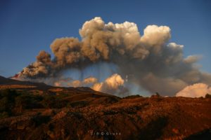
The self-harm of the Southeast Crater: the paroxysm of Etna on February 10, 2022, collapses and pyroclastic flows.
Periods of calm on the great Sicilian volcano never last long. At the end of January 2022, the Southeast Crater again gives signs of life: small explosions and puffs of ash, which stop after 48 hours. They then resumed on the evening of February 9, this time more decisively and continuously. During the following day, the volcanic tremor signal, the one that gives the most a measure of the state of « unrest » in the volcanic system, shows a gradual increase…

The southern flank of the cone of the Southeast Crater of Etna, as it appeared on February 12, 2022, with the deep opening created due to the collapse of the flank during the paroxysm of February 10 in the evening. In the left foreground you can see part of the lava flow mixed with the landslide deposit; bottom right, part of the profile of Monte Barbagallo superiore (the double cone formed during the 2002-2003 eruption).
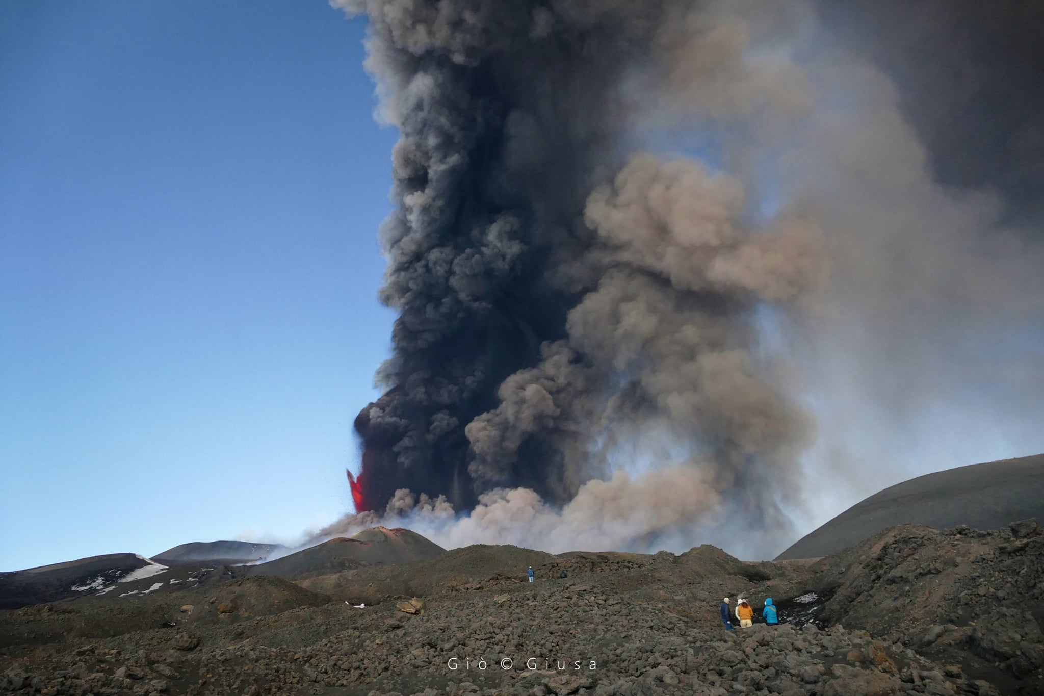
In the afternoon, camera images pointed at the summit craters show a small anomaly, highlighting an overflow of lava flowing out of what in 2021 was known as the « saddle mouth », on the southwest flank of the cone. In the evening, finally, the explosive activity begins to intensify, becoming more and more continuous. Between 8:30 p.m. and 9:15 p.m. (local time), Strombolian activity passes to the stage of pulsating fountains, sometimes 200 to 300 m high, then only a few tens of meters.
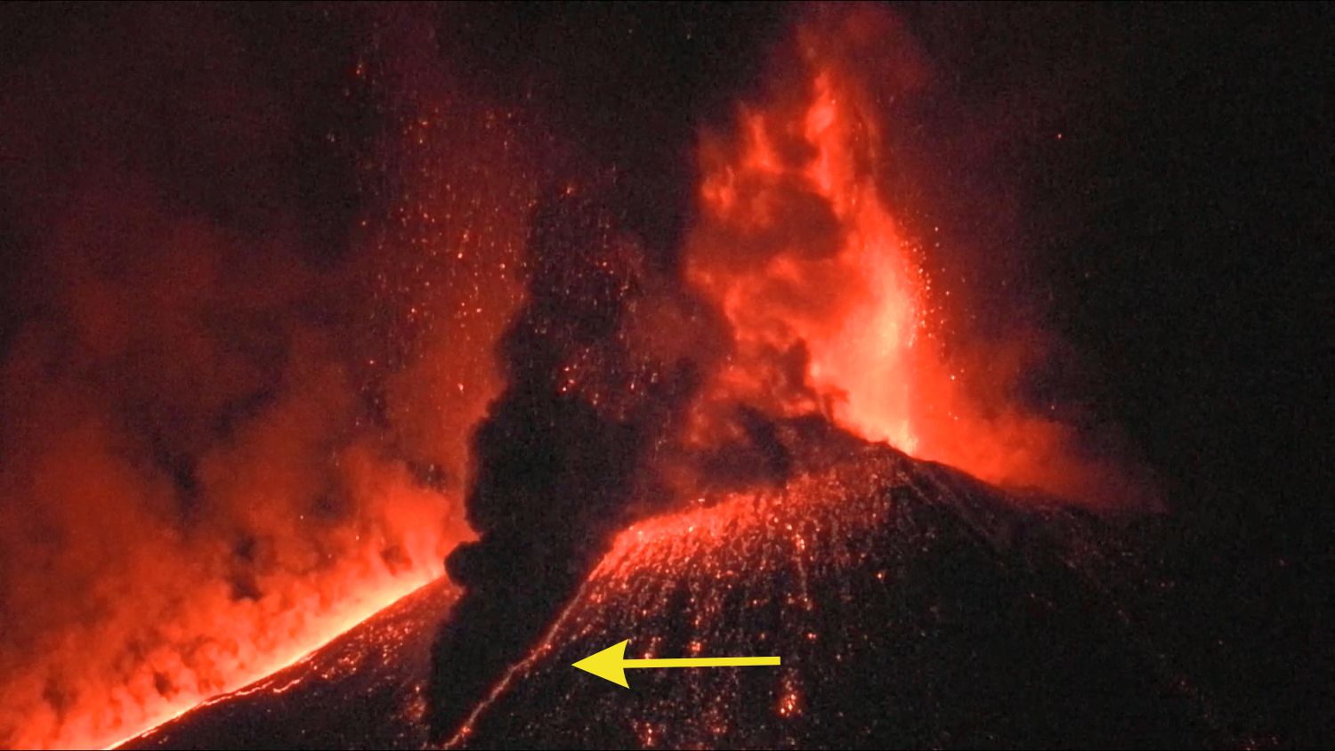
Pyroclastic flow (indicated by the yellow arrow) on the southern flank of the cone of the Southeast Crater at 9:34 p.m. on February 10, 2022.
At 9:34 p.m., heavy fallout of coarse pyroclastic material triggered a good amount of hot material to slide down the steep slope of the cone, forming a pyroclastic flow that reached the base of the cone within seconds. A few minutes later, another pyroclastic flow forms, directed towards the Southeast. The explosive activity increases rapidly, the lava fountains reach heights of more than 1000 m and an eruptive column rises up to 10 km. On the southern flank of the cone, the pyroclastic flows are almost continuous, enveloping a large part of the scene in a black veil. The volcanic bombs reach up to almost 2 km to the south, falling on the double cone of 2002-2003, today known as Monti Barbagallo. In a few short intervals of visibility, in the lower part of the deep niche which opened on the southern flank of the cone of the Southeast Crater, explosions and small fountains of lava could be observed, a sign that the collapse of the flank was probably caused by magma pushing through this sector of the cone.
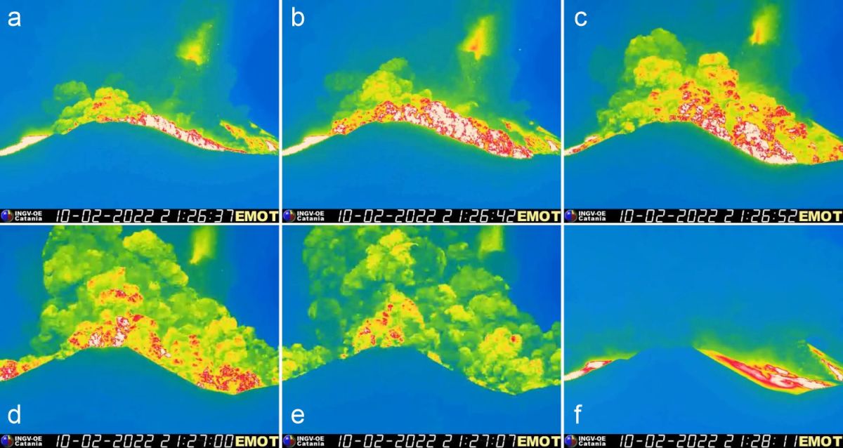
Sequence of images taken by the thermal surveillance camera on Montagnola, showing the progress of the pyroclastic flow produced by the collapse of the southern flank of the cone of the Southeast Crater at 22:26 on February 10, 2022. The high temperature is noted ( white and yellow colors) both in the same flow and in the deposit left by it (f) The cone visible in front of the pyroclastic flow is the lower of the two cones of Mount Barbagallo (2002-2003 eruption), while that the highest is completely enveloped by the flow.
At 10:26 p.m., the south side of the cone of the Southeast Crater was torn, forming an avalanche of volcanic debris and a pyroclastic flow, strongly incandescent, which covered the higher of the two cones of 2002-2003 and extended towards the Southeast and Southwest up to about 1 mile distance. As the pyroclastic flow cloud rises, thermal images reveal the elevated temperature of the deposit it leaves on the ground…/…
WEEKLY BULLETIN from February 14, 2022 to February 20, 2022. (issue date February 22, 2022).
ACTIVITY STATUS SUMMARY.
1) VOLCANOLOGICAL OBSERVATIONS: Ordinary degassing of the summit craters with sporadic and modest ash emissions from the Northeast, Bocca Nuova and Southeast craters
2) SEISMOLOGY: Low seismic activity of fracturing; the amplitude of the volcanic tremor remained mainly at medium-low levels.
3) INFRASONO: moderate infrasonic activity.
4) GROUND DEFORMATIONS: There are no significant variations during the last week.
5) GEOCHEMISTRY: SO2 flux at a medium-low level and moderately increasing
The soil CO2 flux shows average values with an upward trend recorded over the past three days.
The partial pressure of dissolved CO2 in groundwater shows values in seasonal variability with a slight upward trend in the last week
The isotopic ratio of He (Peripheral gases) shows a new increase compared to the previous value, settling on high values (0.66 given on 02/15/2022).
6) SATELLITE OBSERVATIONS: Thermal activity in the summit area was high to very high in correspondence with the February 21, 2022 lava fountain.
The Northeast Crater produced modest ash emissions on February 15 and 18, which were deposited in the summit area. On February 20, there were two small ash emissions from the Southeast Crater, also immediately dispersed in the summit area. Throughout the week, the collapses continued along the unstable walls of the deep notch left by the collapse of the southern flank of the cone of the Southeast Crater on February 10, often generating anomalies in the images of the Montagnola thermal camera (EMOT).
Communication on the activity of ETNA, February 22, 2022, 21:07 (20:07 UTC).
The National Institute of Geophysics and Volcanology, Osservatorio Etneo announces that from around 6 p.m. UTC, the improvement in weather conditions made it possible to observe from surveillance cameras, the resumption of weak Strombolian activity at the South Crater -East and a lava flow that extends along its lower eastern slope. According to the forecast model, the volcanic cloud is dispersing in a southerly direction.
The average amplitude of the volcanic tremor does not show significant changes compared to what is reported in press release n. 549 and remains at medium-low levels. The springs are located in the Bocca Nuova crater area at a depth of approximately 1.5 km above sea level. Infrasound activity is low, however the number of events may be underestimated in due to strong wind.
No significant change is observed in the deformation data measured by the GNSS network.
Further updates will be communicated soon.
Source : INGV.
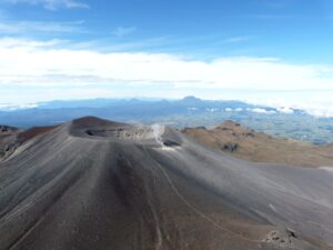
Photos : Francesco Ciancitto , Boris Behncke , INGV, Gio Giusa .
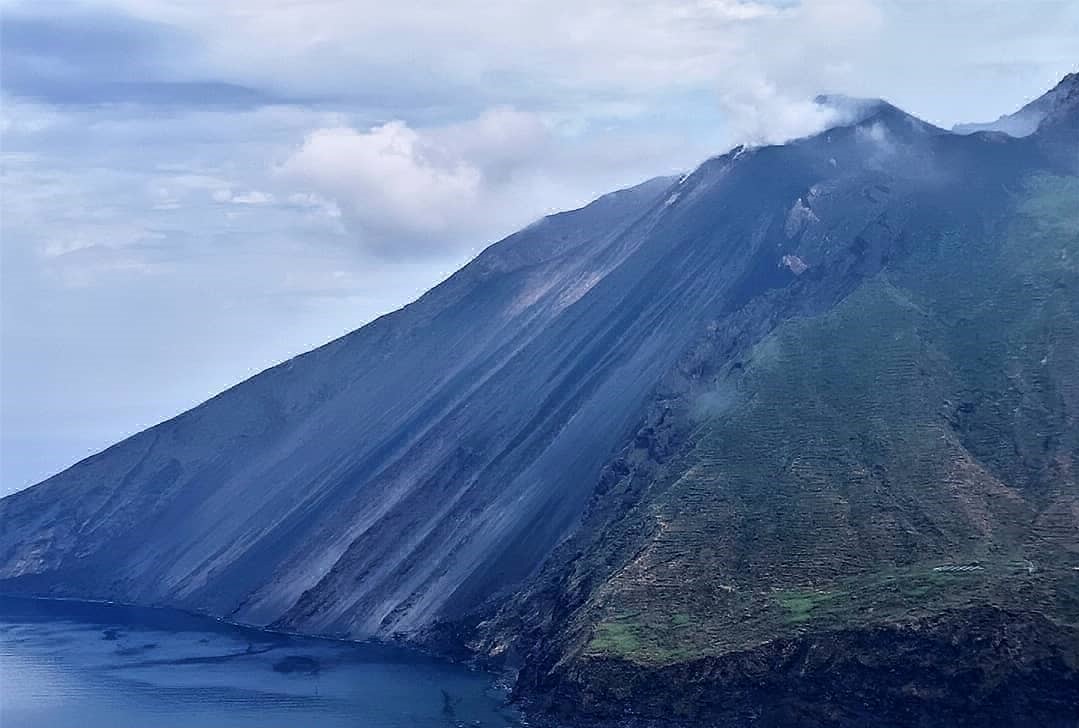
Italy , Stromboli :
WEEKLY BULLETIN from February 14, 2022 to February 20, 2022. (issue date February 22, 2022).
ACTIVITY STATUS SUMMARY
In the light of the surveillance data, it is highlighted:
1) VOLCANOLOGICAL OBSERVATIONS: During this period, normal explosive activity of the Strombolian type was observed with projection activity in the North zone. The total hourly frequency of explosions fluctuated between average values (10 – 15 events / h). The intensity of the explosions was medium and low in the area of the North crater and low in the area of the Center-South crater.
2) SEISMOLOGY: The seismological parameters monitored do not show any significant variations.
3) GROUND DEFORMATIONS: Stromboli ground deformation monitoring networks did not show significant variations
4) GEOCHEMISTRY: SO2 flux at an average level
CO2 flux in the crater area stable at high values.
The C/S value in the plume is 11.54 and is at medium to high values.
There are no updates regarding the isotope ratio of helium.
5) SATELLITE OBSERVATIONS: The thermal activity observed by satellite was at a low level.
VOLCANOLOGICAL OBSERVATIONS
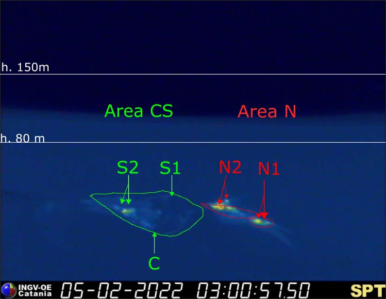
During the observation period, the eruptive activity of Stromboli was characterized through the analysis of images recorded by the INGV-OE surveillance cameras (altitude 190m, Punta Corvi, altitude 400m and Pizzo). The explosive activity was mainly produced by 3 (three) eruptive vents located in the North crater area and 3 (three) eruptive vents located in the Center-South crater area. All the mouths are placed inside the depression which occupies the terrace of the crater.
Due to unfavorable weather conditions on February 16 and 17, 2022, the visibility of the crater terrace was insufficient for a correct description of the eruptive activity.
Sector N1 located in the area of the North crater produced explosions of mainly low intensity (less than 80 m high) and medium (less than 150 m high) emitting coarse materials (lapilli and bombs) sometimes mixed with fine materials (ash). Sector N2, with two emission points, showed low intensity explosive activity (less than 80 m in height) emitting coarse materials with discontinuous and weak projection activity. The average frequency of explosions varied from 4 to 10 events/h.
In the Center-South zone, sector C did not show any significant explosive activity. Sector S1 presented jets of incandescent gas mixed with coarse materials while the two vents placed in sector S2 produced explosions, even simultaneously, of mainly medium-low intensity (sometimes the products of the explosions exceeded 80 m in height) emitting coarse materials mixed with fine materials. The frequency of the explosions varied between 4 and 7 events/h.
Source : INGV.
Photo : Massimiliano Privitera.
Indonesia , Ibu :
VOLCANO OBSERVATORY NOTICE FOR AVIATION – VONA
Issued : February 23 , 2022
Volcano : Ibu (268030)
Current Aviation Colour Code : ORANGE
Previous Aviation Colour Code : orange
Source : Ibu Volcano Observatory
Notice Number : 2022IBU07
Volcano Location : N 01 deg 29 min 17 sec E 127 deg 37 min 48 sec
Area : North Maluku, Indonesia
Summit Elevation : 4240 FT (1325 M)
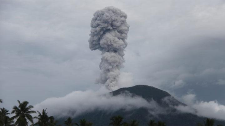
Volcanic Activity Summary :
Eruption with volcanic ash cloud at 01h35 UTC (10h35 local).
Volcanic Cloud Height :
Best estimate of ash-cloud top is around 6800 FT (2125 M) above sea level, may be higher than what can be observed clearly. Source of height data: ground observer.
Other Volcanic Cloud Information :
Ash-cloud moving to southwest.
Remarks :
Eruption and ash emission is continuing.
Sources : Magma Indonésie , PVMBG.
Photo : Tempo .
Chile , Nevados de Chillan :
The seismicity parameters associated with the fracturing processes of rigid materials (VT types) presented a significant decrease, returning to values similar to those presented during the month of December 2021, in the same way, the events associated with the dynamics of fluids (LP, VLP and TR types) and explosive (EX) type events maintain a slight continuous decline since December 2021.
The highest energy VT-type event had a local magnitude (ML) of 1.8 and was located 4 km east-southeast of the volcanic edifice, at a depth of 4 km.
From the analysis of the images provided by the surveillance cameras belonging to the OVDAS as well as satellite images, explosions from the active crater were observed, generally characterized by a moderate content of pyroclasts, generally of low impact. The maximum recorded height was 1,880 m above crater level on February 13.
The occurrence of pyroclastic flows on 05, 07, 09, 12 and 13 February stands out, with a proximal slip distance of less than 600 m from the crater.
No ongoing extrusive processes or relevant changes in crater morphology were observed.
Episodes of intermittent night glow continued to be recorded throughout the period and associated with major events.
According to the data obtained by the network of GNSS stations installed on the volcano, a clear trend of shortening between the stations has been observed, with rates of 0.5 cm / month. While a subsidence was recorded in the vertical component, the value of which reaches -0.4 cm/month.
Six (6) thermal alerts were recorded in the area with a maximum value of 7 MW on February 13, a value considered low for this volcano. Finally, luminance anomalies were detected on February 02, 07, 09 and 14 from the analysis of Sentinel 2-L2A images.
DOAS gas measurement equipment recorded a maximum sulfur dioxide (SO2) emission value of 307 t/d corresponding to February 2, while the average recorded emission was 137 t/d, remaining at values similar to those posted in December.
Source : Cegemar .
Photo : Sernageomin
Colombia , Nevado del Ruiz :
Bulletin of activity level of the Nevado del Ruiz volcano.
The activity level continues at the yellow activity level or (III): changes in the behavior of volcanic activity.
Regarding the monitoring of the activity of the Nevado del Ruiz volcano, the COLOMBIAN GEOLOGICAL SERVICE reports that:
The seismicity related to fluid dynamics inside the volcanic conduits showed a decrease in the number of earthquakes and an increase in the seismic energy released, compared to the previous week. This seismic activity was characterized by the occurrence of continuous volcanic tremors, harmonic tremors, pulses of tremors, some with spasmodic characteristics, earthquakes of long period and very long period types. In general, these signals exhibited moderate to low energy levels, variable spectral content, and were located primarily within Arenas Crater. According to cameras installed in the volcano area, gas and ash emissions associated with some of these signals have been confirmed. Likewise, thanks to the FLIR cameras of the volcanic monitoring network, significant changes in the relative temperature of the emitted materials could be observed.
Seismicity generated by rock fracturing showed a similar number of earthquakes recorded and a decrease in seismic energy released, compared to the previous week. This seismic activity was located mainly in the Arenas crater and in the northeast and east sectors of the volcano and, to a lesser extent, in the southwest and southeast sectors. The depth of the earthquakes varied between 0.5 and 8.0 km. The maximum magnitude recorded during the week was 0.9 ML (Local Magnitude), corresponding to the earthquake recorded on February 15 at 06:32 (local time), located in the Arenas crater, at a depth of 1.7 km.
During the week, there were two episodes of low energy « drumbeat » type seismicity, which were recorded on February 19. This seismicity has been linked to processes of elevation, emplacement-growth and evolution of a lava dome at the bottom of the Arenas crater.
Source : SGC.
Photo : Diana M Bustamante.
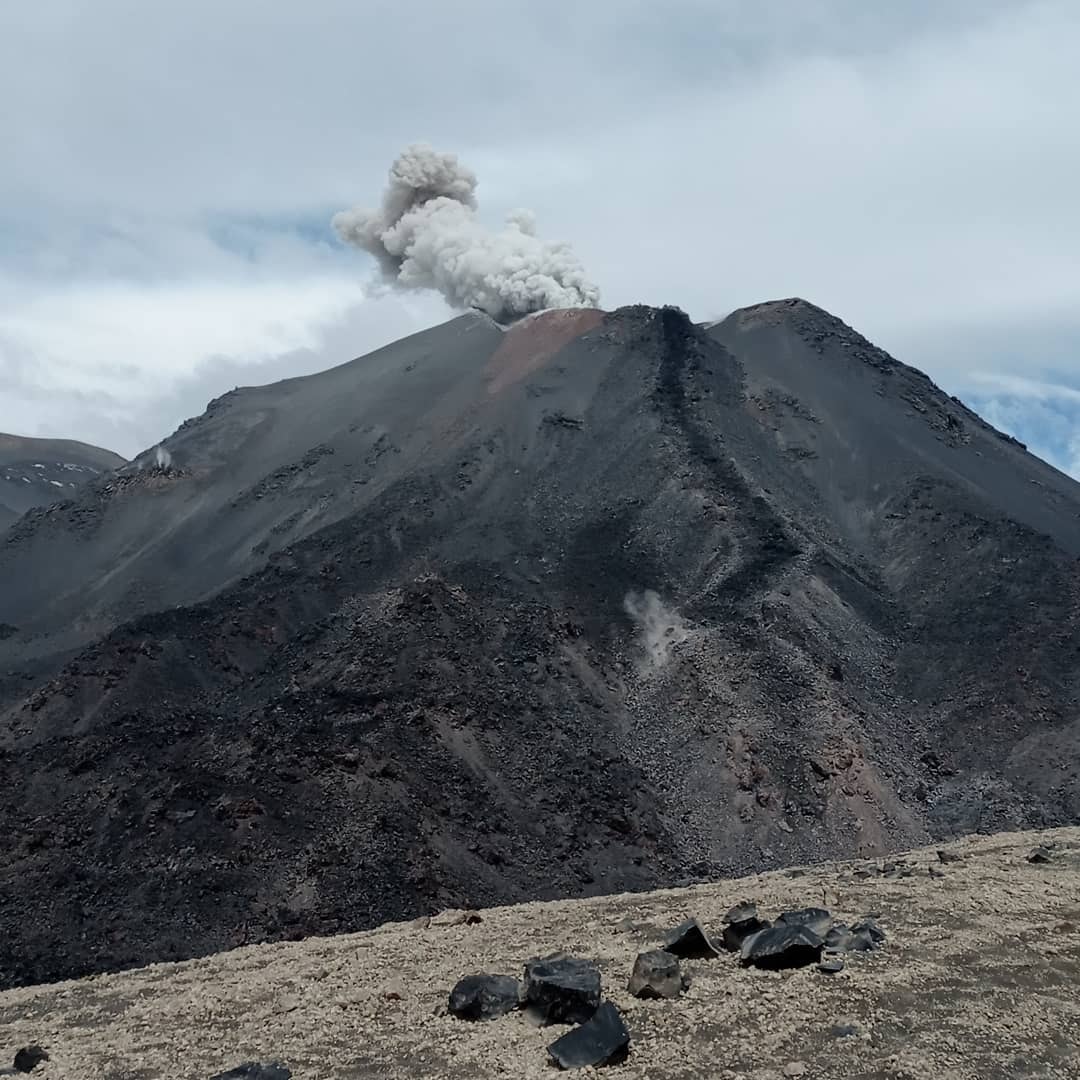
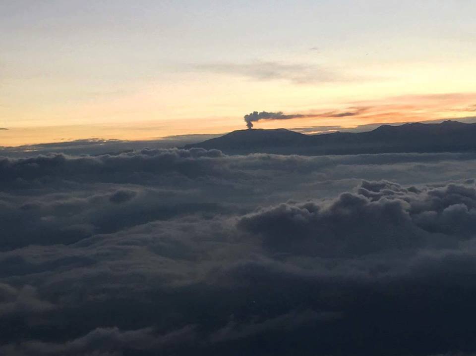
La Palma , Cumbre Vieja :
Post-eruption activity on Cumbre Vieja, La Palma. February 22, 2022, 09:00 UTC.
During the last 7 days, since the last communication (15 at 9:00 UTC), 17 earthquakes have been located on the island of La Palma. The magnitudes are between 0.8 and 2.4 (mbLg). None of the earthquakes located in this period were felt by the population.
The location of the hypocenters continues under the central area of Cumbre Vieja, in the same areas as the previous days, at depths between 1 and 16 km. Only one earthquake over this period was located at a greater depth (26 km).
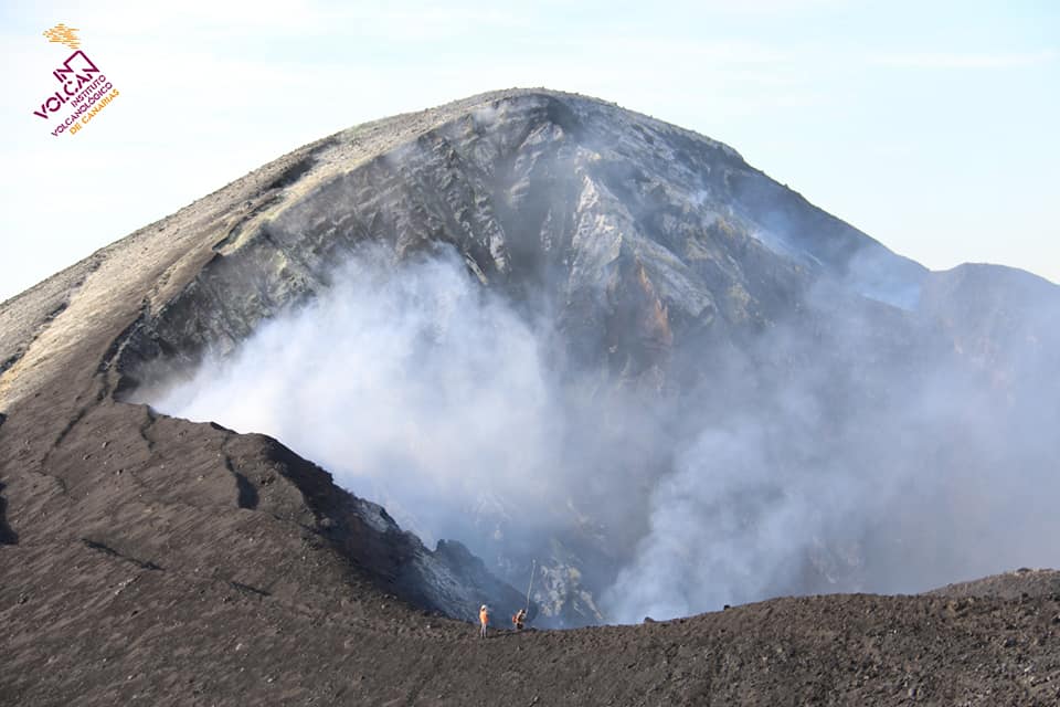
IGN continues to monitor the geochemical network of abnormal carbon dioxide emission control points in the La Bombilla area. Gaseous emission values continue to be very high in certain areas, reaching the saturation limit of CO2 sensors (50,000 ppm). The existence of zones with low oxygen concentrations is also confirmed.
The network of permanent GNSS stations on the island does not show significant deformations that could be associated with volcanic activity.
Source : IGN es
Photo : Involcan.