May 31, 2023. EN. Italy / Sicily : Etna , Italy : Stromboli , Chile : San Pedro , Colombia : Nevado del Ruiz , Costa Rica : Rincon de la Vieja .

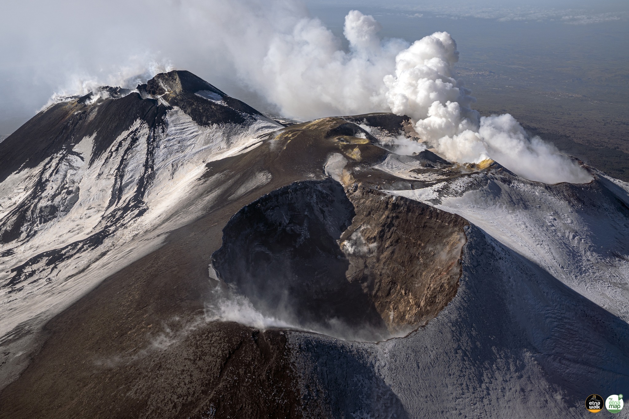
May 31 , 2023.


Italy / Sicily , Etna :

Communique on the activity of Etna, May 30, 2023, 14:20 (12:20 UTC).

The National Institute of Geophysics and Volcanology, Osservatorio Etneo, communicates that according to the monitoring networks recorded at 2:19 p.m. (12:19 UTC), the volcanic tremor and the infrasonic activity do not show significant variations. As for the amplitude of the tremor, it oscillates between medium and medium-low values. The source is located in the Southeast crater area at a depth of 2700 meters above sea level.
For the moment, no volcanic activity is observed in the summit area according to the INGV-OE video surveillance system. Based on the forecast model, the eruptive cloud produced by any ongoing activity is dispersed in a North-North-West direction.
There are no significant variations in the signals from the strain control networks.


WEEKLY BULLETIN, from May 22, 2023 to May 28, 2023 (issue date May 30, 2023)

ACTIVITY STATUS SUMMARY
In the light of the monitoring data, it is highlighted:
1) VOLCANOLOGICAL OBSERVATIONS: Weak intra-crater explosive activity at the level of the Southeast Crater. Degassing activity in the other summit craters.
2) SEISMOLOGY: moderate increase in fracturing seismicity; Seismic swarm on the 28th, located in the northern sector of Valle del Bove. The average amplitude of the tremor varied between
medium-high and low values ​​and the source was located between the area of ​​the central craters and that of the Southeast crater.
3) INFRASOUND: Increase in the rate of occurrence of events, especially in the first three days of the week. The events were mainly located in the area between the Bocca Nuova and Voragine craters and subordinate to the Southeast crater.
4) DEFORMATIONS OF THE GROUND: The stations of the Etna inclinometer network recorded a co-seismic deformation during the earthquake of May 28, 203 Ml=4 at 04:44 UTC, with a maximum deformation of approximately 2 microradians recorded at the level Bada houses. After this episode of deformation, no other significant variation is observed. The GNSS network stations during the week under review did not register any significant changes.

EPVH visible camera images showing explosive activity at the Southeast Crater; photos taken by INGV-OE staff during the inspection of the summit area on May 28 showing A) the crater, B) the Bocca Nuova; C) the Voragine and D) the North-East crater.

5) GEOCHEMISTRY: SO2 flux at an average level
CO2 fluxes increase and are set at medium-high outgassing values
There are no updates on the Helium isotope ratio.
The partial pressure of dissolved CO2 does not show any significant variations.
6) SATELLITE OBSERVATIONS: The thermal activity observed by satellite was moderate after the end of the paroxysmal event at the Southeast Crater on May 21, 2023.
7) OTHER OBSERVATIONS: Analysis of the composition of the semi-proximal pyroclastic deposit (Milia, 8.5 km from the Southeast crater) of the products of the May 21 event indicated a component represented by 98% sideromelane slightly vesicular and only 2% lytic particles. The mean-proximal distribution of the Southeast crater (3.8 – 8.5 km) was estimated between 4 and 7 kg / m2.

VOLCANOLOGICAL OBSERVATIONS
The monitoring of Etna’s volcanic activity was carried out through the analysis of images acquired by the network of INGV surveillance cameras, Osservatorio Etneo (INGV-OE) and through
field inspections carried out by INGV-OE staff. The week was characterized by weak and discontinuous intra-crater explosive activity at the Southeast crater. However, due to the cloud cover of the current week, the observation of the summit craters has been discontinued.

Map of the lava flows in orange and rheomorph in yellow of May 21, 2023 superimposed on the shaded model of the terrain of the summit craters of Etna obtained by processing drone images acquired during several overflights (September 15 and 21, 2022, 6, 21 and October 23), superimposed on the shaded model from the Pléiades images of August 22, 2020 (AO Télédétection). CSE = Southeast Crater, CNE = Northeast Crater, BN = Bocca Nuova, VOR = Voragine

The field activities consisted of field surveys also carried out remotely using drones (on May 27, using Phantom DJI RTK and DJI Mavic 2) acquiring visible and thermal images in order to verify any changes in the morpho-structural state of the volcano’s summit area and to probe the deposits put in place during the eruptive activity of May 21.
Data processing allowed us to limit and reverse the quantitative estimates relating to the lava flow emitted during the eruptive event, the data indicates that the lava field covered an area of 0.3 x 10⁶ m^2 with a length of 2.3 km, reaching an altitude of 2650 m. In addition, the analysis of drone data, as well as the availability of new satellite data, made it possible to redefine and associate the syn-eruptive deposit placed on the eastern slope of the Southeast Crater with a rheomorphic flow of pyroclastic products of explosive activity compared to what is indicated in the Etna Weekly Bulletin of May 23, 2023. Due to the cloud cover which partially hampered the success of the drone surveys, the delimitation of the deposit presents uncertainties on its apical distribution towards the Southeast Crater.

In addition, through the images of the INGV-OE thermal surveillance camera, a weak intra-crater explosive activity was observed on the night of May 23 to 24 at the Southeast Crater and slight glows at the Bocca Nuova crater Finally, on May 28, an inspection was carried out in the summit area by INGV-OE personnel which verified the presence of degassing activity at the level of the Bocca Nuova crater. In addition, the Voragine crater and the Northeast crater were mainly characterized by fumarolic activity.

Source : INGV.

Photo : Giuseppe Distefano , INGV.


Italy , Stromboli :

WEEKLY BULLETIN, from May 22, 2023 to May 28, 2023 (issue date May 30, 2023)

ACTIVITY STATUS SUMMARY
In the light of the monitoring data, it is highlighted:

1) VOLCANOLOGICAL OBSERVATIONS: During this period, normal Strombolian activity was observed with splashing activity in sector C. The total hourly frequency settled on average values (5-12 events/h). The intensity of the explosions was mainly low in the area of the North crater and medium-low in the area of the Center-South crater.
2) SEISMOLOGY: The seismological parameters monitored do not show any significant variations.
3) SOIL DEFORMATIONS: The island’s soil deformation monitoring networks did not show any significant variations to report for the period considered.
4) GEOCHEMISTRY: the flow of SO2 is at an average level
The CO2 flux fluctuates on average degassing values.
There are no C/S data updates.
The R/Ra ratio displays medium to high values.
5) SATELLITE OBSERVATIONS: The thermal activity observed from the satellite was generally weak.

VOLCANOLOGICAL OBSERVATIONS
During the observation period, the eruptive activity of Stromboli was characterized by the analysis of the images recorded by the surveillance cameras of the INGV-OE at an altitude of 190m (SCT-SCV) and of the Pizzo. The explosive activity was mainly produced by 2 (two) eruptive vents located in the North crater area and by 4 (four) vents located in the Center-South area.
Due to a technical failure during May 22, it was not possible to analyze the images for the description of the eruptive activity.

Observations of explosive activity captured by surveillance cameras
The explosive activity of the North crater area was of low intensity (the eruptive products reached a height of less than 80 m).
The products ejected are mainly coarse materials (bombs and lapilli) in sector N2 and fine materials (ash) in sector N1. The average frequency of explosions varies between 3 and 7 events/h.
Sector S1 showed high pressure degassing at times associated with the emission of coarse material, while sector C showed intense spattering activity intermittently on May 27-28. This activity was sometimes interrupted by weak explosions of coarse material. Sector S2, characterized by two active vents, showed low and medium intensity explosive activity with the emission of coarse materials mixed with fine materials. The average frequency of explosions varies between 2 and 7 events/h.

Field and drone observations
As part of the activities provided for by the DPC-INGV Convention, appendix A, and the UNO and Dynamo projects, ground and drone surveys were carried out from May 22 to 25. From the analysis of the shaded relief, developed from the images collected on May 22, combined with field observations, it appears that the canyon which formed last October extends upstream, due to erosion. retrograde. In particular, compared to the last sounding carried out on December 15, it has advanced both towards the East and towards the South-East by about 60 m with a depth varying between 7 and 10 m.

Source : INGV.

Photo : Stromboli Stati d’animo.


Chile , San Pedro :

Special Report on Volcanic Activity (REAV), Antofagasta Region, San Pedro Volcano, May 30, 2023, 8:50 a.m. local time (mainland Chile)

The National Geology and Mining Service of Chile (Sernageomin) announces the following PRELIMINARY information, obtained through the monitoring equipment of the National Volcanic Monitoring Network (RNVV), processed and analyzed at the Volcanological Observatory of the Andes del Sud ( Ovdas):

On Tuesday May 30 at 08:25 local time (12:25 UTC), monitoring stations installed near the San Pedro volcano recorded a swarm of earthquakes, associated with volcano-tectonic activity (VT). At the time of issuing this report, more than 50 localized events have been recorded.


The characteristics of the earthquake of greatest magnitude recorded for the moment after its analysis are as follows:
ORIGINAL TIME: 08:25 local time (12:25 UTC)
LATITUDE: 21.871°S
LONGITUDE: 68.407°E
DEPTH: 0.8 km
LOCAL MAGNITUDE: 4.9 (ML)

Comments:

During the issuance of this report the volcano-tectonic seismicity continues to be recorded.

There are no manifestations of surface activity from the vigilance cameras.

The volcanic technical alert remains at the green level.

Source : Sernageomin.

Photo :  Diego Delso


Colombia , Nevado del Ruiz :

Manizales, May 30, 2023, 11:10 a.m.

Regarding the monitoring of the activity of the NEVADO DEL RUIZ VOLCANO, the MINISTRY OF MINES AND ENERGY through the COLOMBIAN GEOLOGICAL SERVICE (SGC) informs that:

From 9:00 a.m. yesterday (May 29) until the time of publication of this bulletin, seismic activity related to the movement of fluids and that associated with the fracturing of rocks, both inside the volcanic edifice, have showed similar levels in the number of earthquakes recorded and in the seismic energy released, compared to May 28. The earthquakes were located mainly in the Arenas crater and to the northeast and southwest of it, at an approximate distance of up to 5 km from it, and at depths between 1 and 4 km . Earthquake magnitudes remained small.

Regarding the monitoring of the surface activity of the volcano that we carry out by means of web cameras, it was not possible to confirm the ash emissions associated with some of the seismic signals recorded, due to the unfavorable atmospheric conditions. In the region. The maximum height of the gas and steam column reached 700 m measured from the summit of the volcano and showed a preferential direction of dispersion towards the northwest of it. On the other hand, variations continue in the degassing of sulfur dioxide and the release of water vapor from the crater into the atmosphere.

The level of activity of the volcano remains at the ORANGE LEVEL of activity or (II): PROBABLE ERUPTION IN TERM OF DAYS OR WEEKS

Source et photo : SGC


Costa Rica , Rincon de la Vieja :

Latitude: 10.83
Longitude:-85.324
Altitude: 1,916 meters

Observed activity:
The Rincón de la Vieja volcano remains very active with frequent explosive eruptions. The last eruption occurred at 2:44 a.m. The eruption emitted incandescent material and generated a lahar that flowed along the Pénjamo River. When conditions permit, constant degassing is observed this morning

Environmental conditions:
Winds blowing to the South-West; Partly cloudy

Activity Level: Warning (2).

The Rincón de la Vieja volcano, located in Guanacaste, has seen more than 140 eruptions so far this year and activity is expected to continue in the coming weeks.

The massif recorded an eruption the previous Thursday with a column that exceeded 3 thousand meters above the level of the crater. Then, between Saturday and Sunday, it maintained the activity with a « big eruption ».

Despite this situation, the National Emergency Commission (CNE) declared a green alert for the districts of Aguas Claras, Dos Ríos, Curubandé, Mayorga and Cañas Dulces.

Source : Ovsicori , Monumental .co

Photo : Christopher Allen

31 Mai 2023. FR. Italie / Sicile : Etna , Italie : Stromboli , Chili : San Pedro , Colombie : Nevado del Ruiz , Costa Rica : Rincon de la Vieja .

31 Mai 2023.


Italie / Sicile , Etna :

Communiqué sur l’activité de l’Etna , 30 Mai 2023,  14:20 (12:20 UTC) .

L’Institut national de géophysique et de volcanologie, Osservatorio Etneo, communique que d’après les réseaux de surveillance enregistrés à 14h19 (12h19 UTC), le tremor volcanique et l’activité infrasonique ne montrent pas de variations significatives. Quant à l’amplitude du tremor, elle oscille entre des valeurs moyennes et moyennes-basses . La source est située dans la zone du cratère Sud-Est à une profondeur de 2700 mètres d’altitude.
Pour le moment, aucune activité volcanique n’est observée dans la zone du sommet selon les système de vidéosurveillance INGV-OE. Sur la base du modèle de prévision, le nuage éruptif produit par toute activité en cours est dispersé dans une direction Nord-Nord-Ouest.
Il n’y a pas de variations significatives dans les signaux des réseaux de contrôle de déformation.


BULLETIN HEBDOMADAIRE, du 22 Mai 2023 au 28 Mai 2023 .(date d’émission 30 Mai 2023)

RÉSUMÉ DE L’ÉTAT DE L’ACTIVITÉ
A la lumière des données de suivi, il est mis en évidence :
1) OBSERVATIONS VOLCANOLOGIQUES : Faible activité explosive intra-cratère au niveau du Cratère Sud-Est. Activité de dégazage dans les autres cratères sommitaux.
2) SISMOLOGIE : augmentation modérée de la sismicité de fracturation ; Essaim sismique le 28, situé dans le secteur Nord de la Valle del Bove. L’amplitude moyenne du tremor variait entre
des valeurs moyennes-élevées et faibles et la source était située entre la zone des cratères centraux et celle du cratère Sud-Est.
3) INFRASONS : Augmentation du taux d’occurrence des événements, en particulier dans les trois premiers jours de la semaine. Les événements ont été principalement localisés dans la zone située entre les cratères de la Bocca Nuova et la Voragine et de manière subordonnée au cratère Sud-Est.
4) DEFORMATIONS DU SOL : Les stations du réseau inclinométrique de l’Etna ont enregistré une déformation co-sismique lors du séisme du 28 Mai 203 Ml=4 à 04:44 UTC, avec une déformation maximale d’environ 2 microradians enregistrée au niveau des maisons Bada. Après cet épisode de déformation, aucune autre variation significative n’est observée. Les stations du réseau GNSS pendant la semaine sous revue n’a pas enregistré de changements significatifs.

Images de la caméra visible EPVH montrant une activité explosive au Cratère Sud-Es  ; photos prises par le personnel de l’INGV-OE lors de l’inspection de la zone du sommet le 28 mai montrant A)les cratère , B) la Bocca Nuova ; C) la Voragine et D) le cratère Nord-Est.

5) GEOCHIMIE : flux de SO2 à un niveau moyen
Les flux de CO2 augmentent et sont fixés à des valeurs de dégazage moyennes-élevées
Il n’y a pas de mises à jour sur le rapport isotopique de l’Helium.
La pression partielle du CO2 dissous ne présente pas de variations significatives.
6) OBSERVATIONS SATELLITAIRES : L’activité thermique observée par satellite a été modérée après la fin de l’événement paroxystique au Cratère Sud-Est le 21 mai 2023.
7) AUTRES OBSERVATIONS : L’analyse de la composition du dépôt pyroclastique semi-proximal (Milia, à 8,5 km du cratère Sud-Est) des produits de l’événement du 21 mai a indiqué une composante représentée par 98% de sidéromélane légèrement vésiculaire et seulement 2% de particules lytiques. La distribution moyenne-proximale du cratère Sud-Est (3,8 – 8,5 km) a été estimée entre 4 et 7 kg/m2.

OBSERVATIONS VOLCANOLOGIQUES
La surveillance de l’activité volcanique de l’Etna a été réalisée à travers l’analyse des images acquises par le réseau de caméras de surveillance de l’INGV, Osservatorio Etneo (INGV-OE) et à travers
inspections sur le terrain effectuées par le personnel de l’INGV-OE. La semaine a été caractérisée par une activité explosive intra-cratère faible et discontinue au niveau du cratère Sud-Est  . Cependant, en raison de la couverture nuageuse de la semaine en cours, l’observation des cratères sommitaux a été discontinue.

Carte des coulées de lave en orange et rhéomorphe en jaune du 21 mai 2023 superposée au modèle ombré du terrain des cratères sommitaux de l’Etna obtenu par traitement des images drone acquises lors de plusieurs survols (15 et 21 septembre 2022, 6, 21 et 23 octobre) , superposé au modèle ombré issu des images Pléiades du 22 août 2020 (AO Télédétection). CSE = Cratère Sud-Est, CNE = Cratère Nord-Est, BN = Bocca Nuova, VOR = Voragine

Les activités de terrain consistaient en des relevés de terrain également effectués à distance à l’aide de drones (le 27 mai, à l’aide de Phantom DJI RTK et DJI Mavic 2) acquérant des images visibles et thermiques afin de vérifier tout changement de l’état morpho-structurel de la zone du sommet du volcan et pour sonder les dépôts mis en place lors de l’activité éruptive du 21 mai .
Le traitement des données nous a permis de limiter et d’inverser les estimations quantitatives relatives à la coulée de lave émise lors de l’événement éruptif, les données indiquent que le champ de lave couvrait une superficie de 0,3 x 10⁶ m^2 avec une longueur de 2,3 km, atteignant une altitude de 2650 m. De plus, l’analyse des données des drones, ainsi que la disponibilité de nouvelles données satellitaires, ont permis de redéfinir et d’associer le dépôt syn-éruptif placé sur le versant oriental du Cratère Sud-Est à un écoulement rhéomorphe des produits pyroclastiques d’activité explosive par rapport à ce qui est indiqué dans le Bulletin Hebdomadaire Etna du 23 Mai 2023 . En raison de la couverture nuageuse qui a partiellement entravé la réussite des prospections par drone, la délimitation du gisement présente des incertitudes sur sa distribution apicale vers le Cratère Sud-Est .

De plus, à travers les images de la caméra de surveillance thermique INGV-OE, une faible activité explosive intra-cratère a été observée dans la nuit du 23 au 24 mai au Cratère Sud-Est  et de légères lueurs au cratère de la Bocca Nuova Enfin, le 28 mai, une inspection a été effectuée dans la zone du sommet par le personnel de l’INGV-OE qui a permis de vérifier la présence d’une activité de dégazage au niveau du cratère de la Bocca Nuova . De plus, le cratère de la Voragine et le cratère Nord-Est étaient principalement caractérisés par une activité fumerolienne .

Source : INGV.

Photo : Giuseppe Distefano , INGV.


Italie , Stromboli :

BULLETIN HEBDOMADAIRE, du 22 Mai 2023 au 28 Mai 2023 .(date d’émission 30 Mai 2023)

RÉSUMÉ DE L’ÉTAT DE L’ACTIVITÉ
A la lumière des données de suivi, il est mis en évidence :

1) OBSERVATIONS VOLCANOLOGIQUES : Au cours de cette période, une activité strombolienne normale a été observée avec une activité d’éclaboussures dans le secteur C. La fréquence horaire totale s’est établie sur des valeurs moyennes (5-12 événements/h). L’intensité des explosions était principalement faible dans la zone du cratère Nord et moyenne-faible dans la zone du cratère Centre-Sud .
2) SISMOLOGIE : Les paramètres sismologiques suivis ne présentent pas de variations significatives.
3) DEFORMATIONS DES SOLS : Les réseaux de surveillance des déformations des sols de l’île n’ont pas montré de variations significatives à signaler pour la période considérée
4) GEOCHIMIE : le flux de SO2 est à un niveau moyen
Le flux de CO2 fluctue sur des valeurs moyennes de dégazage.
Il n’y a pas de mises à jour des données C/S.
Le rapport R/Ra affiche des valeurs moyennes à élevées.
5) OBSERVATIONS SATELLITAIRES : L’activité thermique observée depuis le satellite était généralement faible.

OBSERVATIONS VOLCANOLOGIQUES
Au cours de la période d’observation, l’activité éruptive du Stromboli a été caractérisée par l’analyse des images enregistrées par les caméras de surveillance de l’INGV-OE à une altitude de 190m (SCT-SCV) et du Pizzo. L’activité explosive a été principalement produite par 2 (deux) évents éruptifs situés dans la zone du cratère Nord et par 4 (quatre) évents situés dans la zone Centre-Sud .
En raison d’une panne technique au cours du 22 mai, il n’a pas été possible d’analyser les images pour la description de l’activité éruptive.

Observations d’activité explosive captées par des caméras de surveillance
L’activité explosive de la zone  du cratère Nord était de faible intensité (les produits éruptifs atteignaient une hauteur inférieure à 80 m).
Les produits éjectés sont principalement des matériaux grossiers (bombes et lapilli) dans le secteur N2 et des matériaux fins (cendres) dans le secteur N1. La fréquence moyenne des explosions varie entre 3 et 7 événements/h.
Le secteur S1 a montré un dégazage à haute pression parfois associé à l’émission de matériaux grossiers, tandis que le secteur C a montré une activité de projection intense par intermittence les 27 et 28 mai. Cette activité était parfois interrompue par de faibles explosions de matériaux grossiers. Le secteur S2, caractérisé par deux évents actifs, a montré une activité explosive de faible et moyenne intensité avec émission de matériaux grossiers mélangés à des matériaux fins. La fréquence moyenne des explosions varie entre 2 et 7 événements/h .

Observations terrain et drone
Dans le cadre des activités prévues par la Convention DPC-INGV, annexe A, et des projets UNO et Dynamo, des relevés terrestres et drones ont été réalisés du 22 au 25 mai. De l’analyse du relief ombré, élaboré à partir des images récoltées le 22 mai, combinées aux observations de terrain, il ressort que le canyon qui s’est formé en octobre dernier se prolonge vers l’amont, du fait de l’érosion rétrograde. En particulier, par rapport au dernier sondage effectué le 15 décembre, il a avancé à la fois vers l’Est et vers le Sud-Est d’environ 60 m avec une profondeur variant entre 7 et 10 m

Source : INGV.

Photo : Stromboli Stati d’animo.


Chili , San Pedro :

Rapport spécial sur l’activité volcanique (REAV), région de Antofagasta,  volcan San Pedro, 30 Mai 2023, 08 h 50, heure locale (Chili continental)

Le Service national de géologie et des mines du Chili (Sernageomin) annonce les informations PRÉLIMINAIRES suivantes, obtenues grâce à l’équipement de surveillance du Réseau national de surveillance volcanique (RNVV), traitées et analysées à l’Observatoire volcanologique des Andes del Sud (Ovdas) :

Le Mardi 30 Mai à 08h25 heure locale (12h25 UTC) , les stations de surveillance installées à proximité du volcan San Pedro ont enregistré un essaim de séismes , associé à une activité volcano-tectoniques ( VT).  A l’heure de l’émission de ce rapport , il a été enregistré plus de 50 évènements  localisés .


Les caractéristiques du séisme de plus grande magnitude enregistré pour le moment après son analyse sont les suivantes :
HEURE D’ORIGINE : 08h25 heure locale (12h25 UTC)
LATITUDE : 21.871° S
LONGITUDE : 68.407° E
PROFONDEUR : 0,8 km
MAGNITUDE LOCALE : 4,9 (ML)

Observations :

Durant l’émission de ce rapport la sismicité volcano-tectonique continue d’etre enregistrée .

Il n’y a pas de manifestations d’activité de surface depuis les caméras de vigilance.

L’alerte technique volcanique reste au niveau vert.

Source : Sernageomin.

Photo :  Diego Delso


Colombie , Nevado del Ruiz :

Manizales, 30 mai 2023 ,11h10 .

Concernant le suivi de l’activité du VOLCAN NEVADO DEL RUIZ, le MINISTÈRE DES MINES ET DE L’ÉNERGIE à travers le SERVICE GÉOLOGIQUE COLOMBIEN (SGC) informe que :

Depuis 9h00 hier (29 mai) jusqu’au moment de la publication de ce bulletin, l’activité sismique liée au mouvement des fluides et celle associée à la fracturation des roches, à la fois à l’intérieur de l’édifice volcanique, ont montré des niveaux similaires dans le nombre de tremblements de terre enregistrés et dans l’énergie sismique libérée, par rapport au 28 mai. Les tremblements de terre étaient situés principalement dans le cratère Arenas et au Nord-Est et Sud-Ouest de celui-ci, à une distance approximative allant jusqu’à 5 km de celui-ci, et à des profondeurs comprises entre 1 et 4 km. Les magnitudes des tremblements de terre sont restées faibles.

En ce qui concerne la surveillance de l’activité de surface du volcan que nous effectuons au moyen de caméras Web, il n’a pas été possible de confirmer les émissions de cendres associées à certains des signaux sismiques enregistrés, en raison des conditions atmosphériques défavorables dans la région. La hauteur maximale de la colonne de gaz et de vapeur a atteint 700 m mesurée depuis le sommet du volcan et a montré une direction de dispersion préférentielle vers le Nord-Ouest de celui-ci. D’autre part, les variations se poursuivent dans le dégazage du dioxyde de soufre et le dégagement de vapeur d’eau du cratère dans l’atmosphère.

Le niveau d’activité du volcan reste au NIVEAU ORANGE d’activité ou (II): ERUPTION PROBABLE EN TERME DE JOURS OU DE SEMAINES

Source et photo : SGC


Costa Rica , Rincon de la Vieja :

Latitude : 10,83
Longitude:-85.324
Altitude : 1 916 mètres

Activité observée :
Le volcan Rincón de la Vieja reste très actif avec de fréquentes éruptions explosives. La dernière éruption s’est produite à 02h44. L’éruption a émis des matériaux incandescents et a généré un lahar qui a coulé le long de la rivière Pénjamo. Lorsque les conditions le permettent, un dégazage constant est observé ce matin

Conditions environnementales:
Vents soufflant vers le Sud-Ouest ; Partiellement nuageux

Niveau d’activité : Avertissement (2).

Le volcan Rincón de la Vieja, situé à Guanacaste, a connu plus de 140 éruptions jusqu’à présent cette année et l’activité devrait se poursuivre dans les semaines à venir.

Le massif a enregistré une éruption le jeudi précédent avec une colonne qui a dépassé 3 mille mètres au-dessus du niveau du cratère. Puis, entre samedi et dimanche, il a maintenu l’activité avec une « grosse éruption ».

Malgré cette situation, la Commission nationale d’urgence (CNE) a déclaré une alerte verte pour les districts d’Aguas Claras, Dos Ríos, Curubandé, Mayorga et Cañas Dulces.

Source : Ovsicori , Monumental .co

Photo : Christopher Allen