May 31 , 2023.
Italy / Sicily , Etna :
Communique on the activity of Etna, May 30, 2023, 14:20 (12:20 UTC).
The National Institute of Geophysics and Volcanology, Osservatorio Etneo, communicates that according to the monitoring networks recorded at 2:19 p.m. (12:19 UTC), the volcanic tremor and the infrasonic activity do not show significant variations. As for the amplitude of the tremor, it oscillates between medium and medium-low values. The source is located in the Southeast crater area at a depth of 2700 meters above sea level.
For the moment, no volcanic activity is observed in the summit area according to the INGV-OE video surveillance system. Based on the forecast model, the eruptive cloud produced by any ongoing activity is dispersed in a North-North-West direction.
There are no significant variations in the signals from the strain control networks.
WEEKLY BULLETIN, from May 22, 2023 to May 28, 2023 (issue date May 30, 2023)
ACTIVITY STATUS SUMMARY
In the light of the monitoring data, it is highlighted:
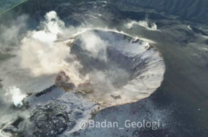
1) VOLCANOLOGICAL OBSERVATIONS: Weak intra-crater explosive activity at the level of the Southeast Crater. Degassing activity in the other summit craters.
2) SEISMOLOGY: moderate increase in fracturing seismicity; Seismic swarm on the 28th, located in the northern sector of Valle del Bove. The average amplitude of the tremor varied between
medium-high and low values and the source was located between the area of the central craters and that of the Southeast crater.
3) INFRASOUND: Increase in the rate of occurrence of events, especially in the first three days of the week. The events were mainly located in the area between the Bocca Nuova and Voragine craters and subordinate to the Southeast crater.
4) DEFORMATIONS OF THE GROUND: The stations of the Etna inclinometer network recorded a co-seismic deformation during the earthquake of May 28, 203 Ml=4 at 04:44 UTC, with a maximum deformation of approximately 2 microradians recorded at the level Bada houses. After this episode of deformation, no other significant variation is observed. The GNSS network stations during the week under review did not register any significant changes.
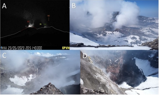
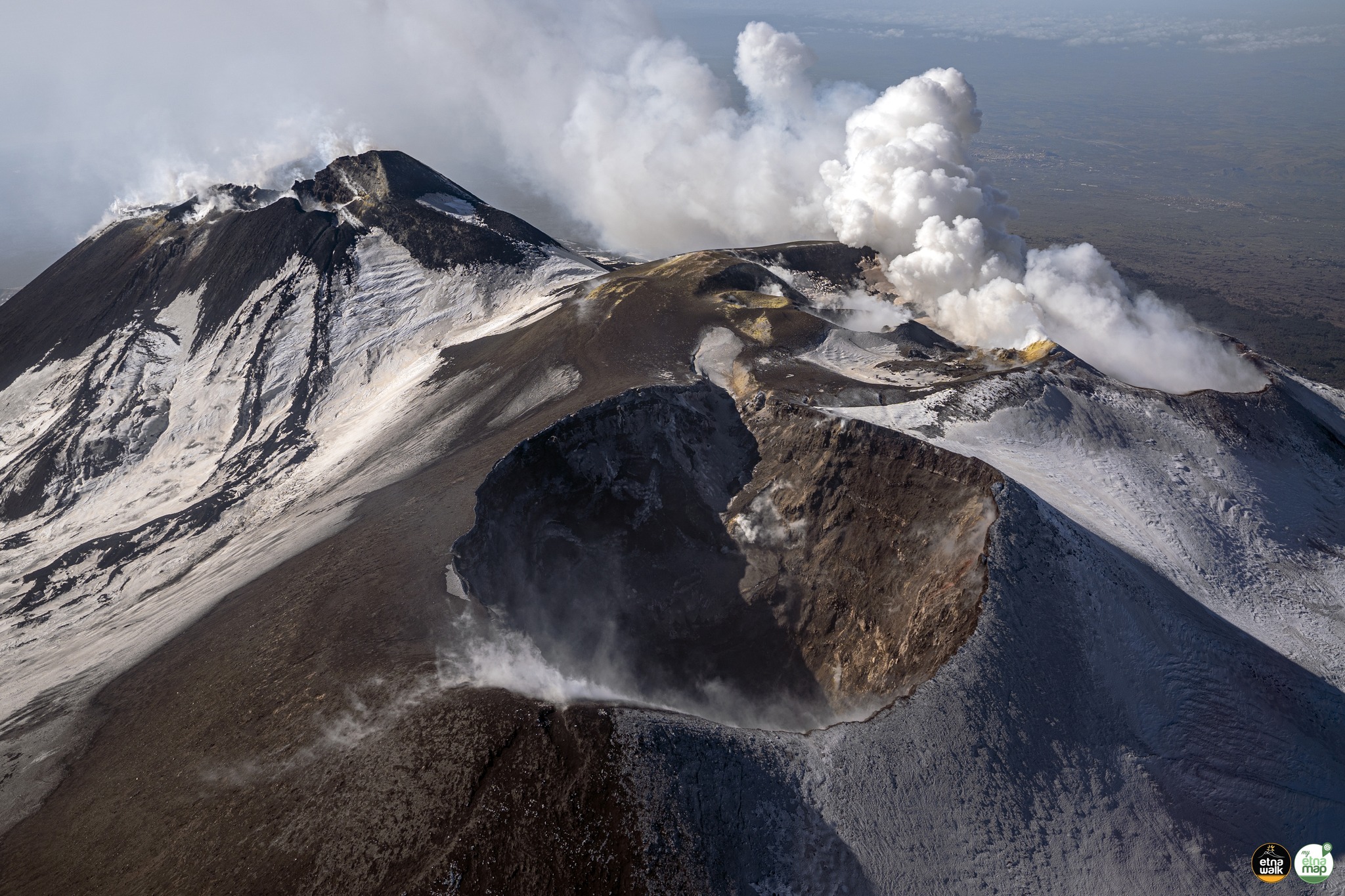
EPVH visible camera images showing explosive activity at the Southeast Crater; photos taken by INGV-OE staff during the inspection of the summit area on May 28 showing A) the crater, B) the Bocca Nuova; C) the Voragine and D) the North-East crater.
5) GEOCHEMISTRY: SO2 flux at an average level
CO2 fluxes increase and are set at medium-high outgassing values
There are no updates on the Helium isotope ratio.
The partial pressure of dissolved CO2 does not show any significant variations.
6) SATELLITE OBSERVATIONS: The thermal activity observed by satellite was moderate after the end of the paroxysmal event at the Southeast Crater on May 21, 2023.
7) OTHER OBSERVATIONS: Analysis of the composition of the semi-proximal pyroclastic deposit (Milia, 8.5 km from the Southeast crater) of the products of the May 21 event indicated a component represented by 98% sideromelane slightly vesicular and only 2% lytic particles. The mean-proximal distribution of the Southeast crater (3.8 – 8.5 km) was estimated between 4 and 7 kg / m2.
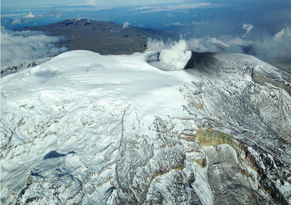
VOLCANOLOGICAL OBSERVATIONS
The monitoring of Etna’s volcanic activity was carried out through the analysis of images acquired by the network of INGV surveillance cameras, Osservatorio Etneo (INGV-OE) and through
field inspections carried out by INGV-OE staff. The week was characterized by weak and discontinuous intra-crater explosive activity at the Southeast crater. However, due to the cloud cover of the current week, the observation of the summit craters has been discontinued.
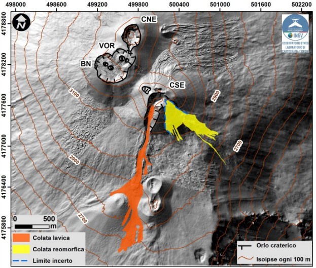
Map of the lava flows in orange and rheomorph in yellow of May 21, 2023 superimposed on the shaded model of the terrain of the summit craters of Etna obtained by processing drone images acquired during several overflights (September 15 and 21, 2022, 6, 21 and October 23), superimposed on the shaded model from the Pléiades images of August 22, 2020 (AO Télédétection). CSE = Southeast Crater, CNE = Northeast Crater, BN = Bocca Nuova, VOR = Voragine
The field activities consisted of field surveys also carried out remotely using drones (on May 27, using Phantom DJI RTK and DJI Mavic 2) acquiring visible and thermal images in order to verify any changes in the morpho-structural state of the volcano’s summit area and to probe the deposits put in place during the eruptive activity of May 21.
Data processing allowed us to limit and reverse the quantitative estimates relating to the lava flow emitted during the eruptive event, the data indicates that the lava field covered an area of 0.3 x 10⁶ m^2 with a length of 2.3 km, reaching an altitude of 2650 m. In addition, the analysis of drone data, as well as the availability of new satellite data, made it possible to redefine and associate the syn-eruptive deposit placed on the eastern slope of the Southeast Crater with a rheomorphic flow of pyroclastic products of explosive activity compared to what is indicated in the Etna Weekly Bulletin of May 23, 2023. Due to the cloud cover which partially hampered the success of the drone surveys, the delimitation of the deposit presents uncertainties on its apical distribution towards the Southeast Crater.
In addition, through the images of the INGV-OE thermal surveillance camera, a weak intra-crater explosive activity was observed on the night of May 23 to 24 at the Southeast Crater and slight glows at the Bocca Nuova crater Finally, on May 28, an inspection was carried out in the summit area by INGV-OE personnel which verified the presence of degassing activity at the level of the Bocca Nuova crater. In addition, the Voragine crater and the Northeast crater were mainly characterized by fumarolic activity.
Source : INGV.
Photo : Giuseppe Distefano , INGV.
Italy , Stromboli :
WEEKLY BULLETIN, from May 22, 2023 to May 28, 2023 (issue date May 30, 2023)
ACTIVITY STATUS SUMMARY
In the light of the monitoring data, it is highlighted:
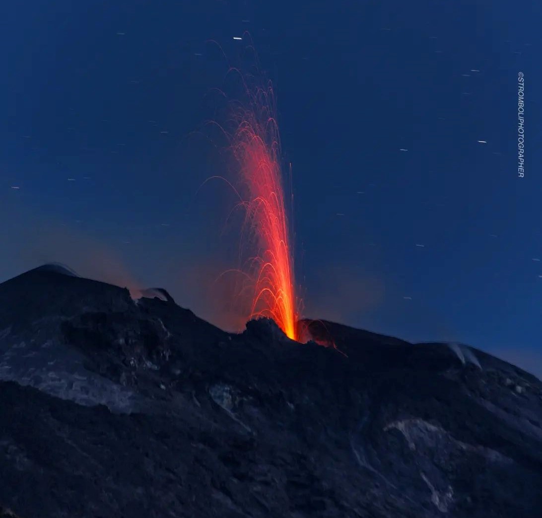
1) VOLCANOLOGICAL OBSERVATIONS: During this period, normal Strombolian activity was observed with splashing activity in sector C. The total hourly frequency settled on average values (5-12 events/h). The intensity of the explosions was mainly low in the area of the North crater and medium-low in the area of the Center-South crater.
2) SEISMOLOGY: The seismological parameters monitored do not show any significant variations.
3) SOIL DEFORMATIONS: The island’s soil deformation monitoring networks did not show any significant variations to report for the period considered.
4) GEOCHEMISTRY: the flow of SO2 is at an average level
The CO2 flux fluctuates on average degassing values.
There are no C/S data updates.
The R/Ra ratio displays medium to high values.
5) SATELLITE OBSERVATIONS: The thermal activity observed from the satellite was generally weak.
VOLCANOLOGICAL OBSERVATIONS
During the observation period, the eruptive activity of Stromboli was characterized by the analysis of the images recorded by the surveillance cameras of the INGV-OE at an altitude of 190m (SCT-SCV) and of the Pizzo. The explosive activity was mainly produced by 2 (two) eruptive vents located in the North crater area and by 4 (four) vents located in the Center-South area.
Due to a technical failure during May 22, it was not possible to analyze the images for the description of the eruptive activity.
Observations of explosive activity captured by surveillance cameras
The explosive activity of the North crater area was of low intensity (the eruptive products reached a height of less than 80 m).
The products ejected are mainly coarse materials (bombs and lapilli) in sector N2 and fine materials (ash) in sector N1. The average frequency of explosions varies between 3 and 7 events/h.
Sector S1 showed high pressure degassing at times associated with the emission of coarse material, while sector C showed intense spattering activity intermittently on May 27-28. This activity was sometimes interrupted by weak explosions of coarse material. Sector S2, characterized by two active vents, showed low and medium intensity explosive activity with the emission of coarse materials mixed with fine materials. The average frequency of explosions varies between 2 and 7 events/h.
Field and drone observations
As part of the activities provided for by the DPC-INGV Convention, appendix A, and the UNO and Dynamo projects, ground and drone surveys were carried out from May 22 to 25. From the analysis of the shaded relief, developed from the images collected on May 22, combined with field observations, it appears that the canyon which formed last October extends upstream, due to erosion. retrograde. In particular, compared to the last sounding carried out on December 15, it has advanced both towards the East and towards the South-East by about 60 m with a depth varying between 7 and 10 m.
Source : INGV.
Photo : Stromboli Stati d’animo.
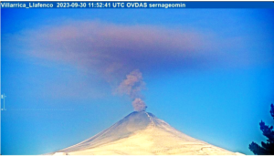
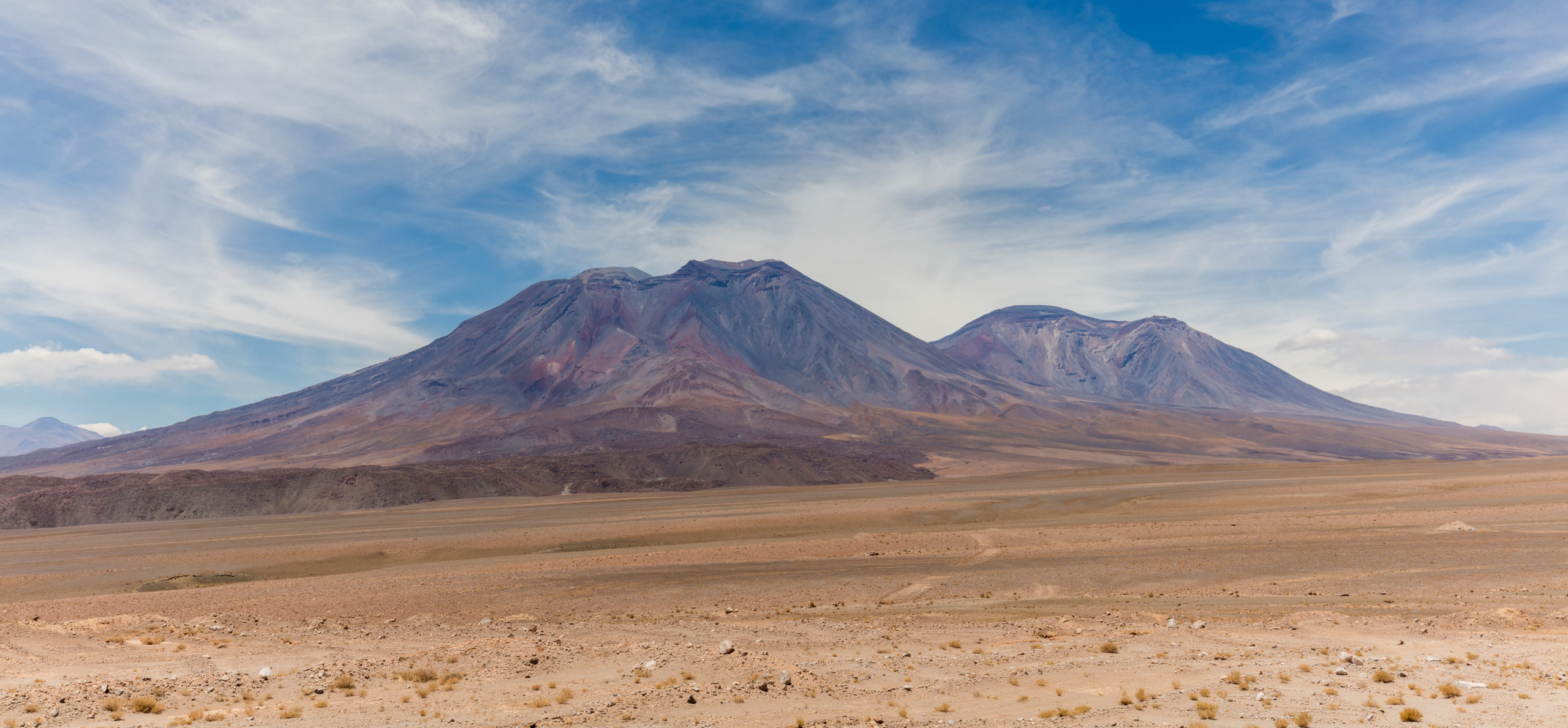
Chile , San Pedro :
Special Report on Volcanic Activity (REAV), Antofagasta Region, San Pedro Volcano, May 30, 2023, 8:50 a.m. local time (mainland Chile)
The National Geology and Mining Service of Chile (Sernageomin) announces the following PRELIMINARY information, obtained through the monitoring equipment of the National Volcanic Monitoring Network (RNVV), processed and analyzed at the Volcanological Observatory of the Andes del Sud ( Ovdas):
On Tuesday May 30 at 08:25 local time (12:25 UTC), monitoring stations installed near the San Pedro volcano recorded a swarm of earthquakes, associated with volcano-tectonic activity (VT). At the time of issuing this report, more than 50 localized events have been recorded.
The characteristics of the earthquake of greatest magnitude recorded for the moment after its analysis are as follows:
ORIGINAL TIME: 08:25 local time (12:25 UTC)
LATITUDE: 21.871°S
LONGITUDE: 68.407°E
DEPTH: 0.8 km
LOCAL MAGNITUDE: 4.9 (ML)
Comments:
During the issuance of this report the volcano-tectonic seismicity continues to be recorded.
There are no manifestations of surface activity from the vigilance cameras.
The volcanic technical alert remains at the green level.
Source : Sernageomin.
Photo : Diego Delso
Colombia , Nevado del Ruiz :
Manizales, May 30, 2023, 11:10 a.m.
Regarding the monitoring of the activity of the NEVADO DEL RUIZ VOLCANO, the MINISTRY OF MINES AND ENERGY through the COLOMBIAN GEOLOGICAL SERVICE (SGC) informs that:
From 9:00 a.m. yesterday (May 29) until the time of publication of this bulletin, seismic activity related to the movement of fluids and that associated with the fracturing of rocks, both inside the volcanic edifice, have showed similar levels in the number of earthquakes recorded and in the seismic energy released, compared to May 28. The earthquakes were located mainly in the Arenas crater and to the northeast and southwest of it, at an approximate distance of up to 5 km from it, and at depths between 1 and 4 km . Earthquake magnitudes remained small.
Regarding the monitoring of the surface activity of the volcano that we carry out by means of web cameras, it was not possible to confirm the ash emissions associated with some of the seismic signals recorded, due to the unfavorable atmospheric conditions. In the region. The maximum height of the gas and steam column reached 700 m measured from the summit of the volcano and showed a preferential direction of dispersion towards the northwest of it. On the other hand, variations continue in the degassing of sulfur dioxide and the release of water vapor from the crater into the atmosphere.
The level of activity of the volcano remains at the ORANGE LEVEL of activity or (II): PROBABLE ERUPTION IN TERM OF DAYS OR WEEKS
Source et photo : SGC
Costa Rica , Rincon de la Vieja :
Latitude: 10.83
Longitude:-85.324
Altitude: 1,916 meters
Observed activity:
The Rincón de la Vieja volcano remains very active with frequent explosive eruptions. The last eruption occurred at 2:44 a.m. The eruption emitted incandescent material and generated a lahar that flowed along the Pénjamo River. When conditions permit, constant degassing is observed this morning
Environmental conditions:
Winds blowing to the South-West; Partly cloudy
Activity Level: Warning (2).
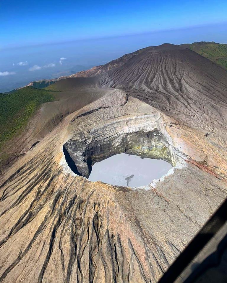
The Rincón de la Vieja volcano, located in Guanacaste, has seen more than 140 eruptions so far this year and activity is expected to continue in the coming weeks.
The massif recorded an eruption the previous Thursday with a column that exceeded 3 thousand meters above the level of the crater. Then, between Saturday and Sunday, it maintained the activity with a « big eruption ».
Despite this situation, the National Emergency Commission (CNE) declared a green alert for the districts of Aguas Claras, Dos Ríos, Curubandé, Mayorga and Cañas Dulces.
Source : Ovsicori , Monumental .co
Photo : Christopher Allen