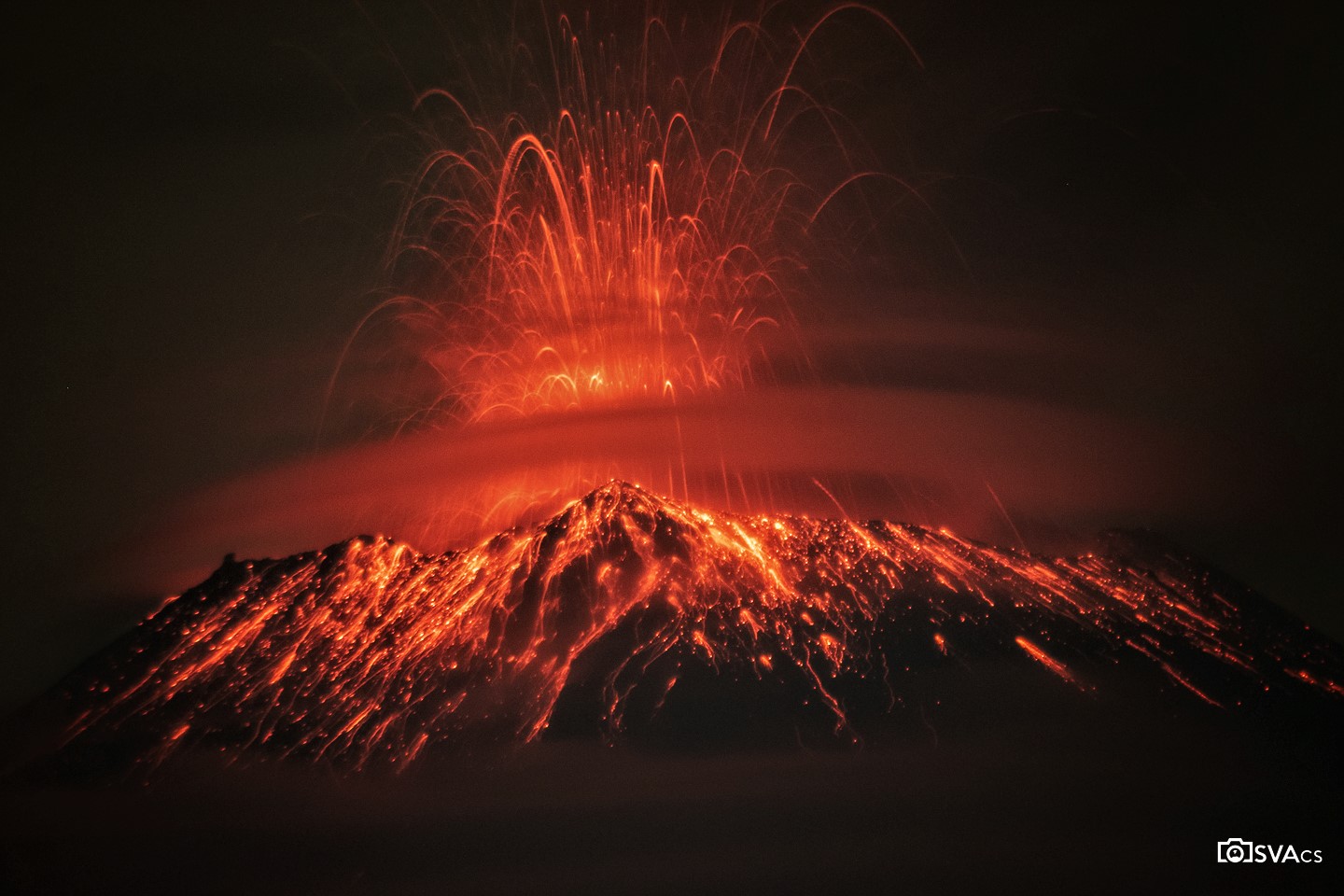
May 21, 2023. EN. Italy / Sicily : Etna , Mexico : Popocatepetl , Indonesia : Semeru , Colombia : Nevado del Ruiz , Democratic Republic of Congo : Nyamulagira .

May 21 , 2023.


Italy / Sicily , Etna :

Communique on the activity of Etna, May 21, 2023, 05:51 (03:51 UTC).

The National Institute of Geophysics and Volcanology, Osservatorio Etneo, communicates that due to the cloud cover, which persists in the summit area of the volcano, it is not possible to carry out volcanological observations via the video surveillance network.

From the seismic point of view, there are no significant variations. The ETNAS system has changed to F0 status.
In the hours following the previous press release, the signals from the permanent GNSS and clinometer networks for deformation control did not show any significant variations.

Further updates will be communicated soon.

Source and photo : INGV.


Mexico , Popocatepetl :

May 20, 11:00 a.m. (May 20, 5:00 p.m. GMT)

During the last 24 hours, according to the monitoring systems of the Popocatépetl volcano, 94 exhalations accompanied by water vapor, volcanic gases and ash have been detected. In addition, 674 minutes of high frequency tremor were recorded, accompanied by the emission of incandescent fragments on the flanks of the volcano. In addition, three minor explosions were recorded today at 6:14 a.m., 6:56 a.m. and 9:00 a.m. and a moderate explosion today at 3:18 a.m.

CENACOM (National Center for Communication and Civil Protection Operations) reported this morning a slight fall of ash in Tétela del Volcán, Morelos, in the localities of Venustiano Carranza, Gustavo A. Madero, Azcapotzalco, Tlalpan and Iztapalapa in Mexico City, in the municipalities of Zumpango, Tlalmanalco, Ecatepec, Chicoloapan, Amecameca, Ayapango, Ozumba, Ecatzingo, Atlautla, Chalco, Temamatla, Tenango del Aire, Juchitepec, Cocotitlán, Tepetlixpa, Tonanitla, Tecámac, Jaltenco, Chiconcuac and Acolman in the State of Mexico.

In the early hours of the morning, due to the ash fall, the airports of Mexico City and Felipe Ángeles closed their doors.

At the time of this report, although there is partial visibility towards the volcano due to weather conditions in the area, a constant emission of water vapor, volcanic gases and light amounts of ash has been observed in a North-West (NW) direction.

CENAPRED insistently reiterates the recommendation NOT TO CLIMB to the crater of the volcano, because there is the possibility of explosions, as has been seen on several occasions in the past, involving the emission of incandescent fragments. Therefore, he is required to respect the exclusion radius of 12 km. Also, in heavy rain, stay away from the bottom of ravines due to the danger of mudslides and debris.

The Popocatépetl volcanic alert traffic light is in YELLOW PHASE 2.

Source : Cenapred .

Photos : OsvaCs , Cenapred.


Indonesia , Semeru :

VOLCANO OBSERVATORY NOTICE FOR AVIATION – VONA

Issued : May 20 , 2023
Volcano : Semeru (263300)
Current Aviation Colour Code : ORANGE
Previous Aviation Colour Code : orange
Source : Semeru Volcano Observatory
Notice Number : 2023SMR192
Volcano Location : S 08 deg 06 min 29 sec E 112 deg 55 min 12 sec
Area : East java, Indonesia
Summit Elevation : 11763 FT (3676 M)

Volcanic Activity Summary :
Eruption with volcanic ash cloud at 22h45 UTC (05h45 local).

Volcanic Cloud Height :
Best estimate of ash-cloud top is around 13683 FT (4276 M) above sea level or 1920 FT (600 M) above summit. May be higher than what can be observed clearly. Source of height data: ground observer.

Other Volcanic Cloud Information :
Ash cloud moving to north. Volcanic ash is observed to be gray. The intensity of volcanic ash is observed to be thick.

Remarks :
Eruption recorded on seismogram with maximum amplitude 22 mm and maximum duration 108 second.

Source : Magma Indonésie.

Photo : Oystein Lund Andersen


Colombia , Nevado del Ruiz :

Manizales, May 20, 2023 10:05 a.m.

Regarding the monitoring of the activity of the NEVADO DEL RUIZ VOLCANO, the MINISTRY OF MINES AND ENERGY through the COLOMBIAN GEOLOGICAL SERVICE (SGC) informs that:

From 9:00 a.m. yesterday (May 19) until the time of publication of this bulletin, seismic activity associated with the fracturing of rock inside the volcanic edifice has maintained similar levels in the number of earthquakes. and in the seismic energy released, compared to the day before. (May 18). This seismicity was located mainly in the North-North-West sector and, to a lesser extent, in the North-East and South-East sectors of the volcano, as well as in the Arenas crater, at a maximum distance of 8 km from it. this. The earthquakes had low magnitudes and their depths varied between 1 and 6 km.

Regarding the seismicity related to the movement of fluids inside the volcanic conduits, this activity has maintained low levels in the number of earthquakes and in the seismic energy released, although it has shown a slight increase compared to the previous day (May 18). Some of the seismic signals were associated with pulsating ash emissions confirmed by web cameras used for volcanic monitoring.

In addition, variations continue in the degassing of sulfur dioxide and the release of water vapor from the crater into the atmosphere. The maximum height of the gas column was 900 m,
measured from the top of the volcano. The direction of dispersion of the column was mainly towards the southwest of the volcanic structure. Yesterday, it was not possible to observe the existing thermal anomaly at the bottom of the crater, due to the amount of gas and steam emitted by the volcano.

Source et photo : SGC


Democratic Republic of Congo , Nyamulagira :

It is since the evening of this Friday, May 19 that a red glow is observed on the north side of the city of Goma, in North Kivu, where two active volcanoes of the Virunga chain are located.

According to officials from the Volcanological Observatory of Goma (OVG), it is the Nyamulagira volcano that is erupting.

“Yesterday, we released a press release to tell the population that the Nyamulagira is active in its crater and that if it ever erupts, it will move in the park. So it is the Nyamulagira volcano which is erupting inside its crater, ”confirmed Kasereka Mahinda Célestin, scientific director of the OVG.

According to him, there is nothing to fear for the population of the city of Goma, because this volcano is still oriented in the Virunga park and the Nyiragongo volcano which stands as a protective wall against the flow of lava. .

In a recent press release, however, the OVG called on the population of Goma to observe hygiene measures, especially by washing vegetables well.

Source :  Mediacongo

Photo :Charles Balagizi

21 Mai 2023. FR. Italie / Sicile : Etna , Mexique : Popocatepetl , Indonésie : Semeru , Colombie : Nevado del Ruiz , République Démocratique du Congo : Nyamulagira .

21 Mai 2023.


Italie / Sicile , Etna :

Communiqué sur l’activité de l’Etna , 21 Mai 2023 , 05:51 (03:51 UTC) .

L’Institut national de géophysique et de volcanologie, Osservatorio Etneo, communique qu’en raison de la couverture nuageuse, qui persiste dans la zone sommitale du volcan, il n’est pas possible d’effectuer des observations volcanologiques via le réseau de vidéosurveillance.

Du point de vue sismique, il n’y a pas de variations significatives. Le système ETNAS est passé au statut F0.
Dans les heures qui ont suivi le précédent communiqué de presse, les signaux des réseaux permanents GNSS et clinomètres pour le contrôle des déformations n’ont pas montré de variations significatives.

D’autres mises à jour seront communiquées rapidement.

Source : INGV.


Mexique , Popocatepetl :

20 mai, 11h00 (20 mai, 17h00 GMT)

Au cours des dernières 24 heures, selon les systèmes de surveillance du volcan Popocatépetl, 94 exhalaisons accompagnées de vapeur d’eau, de gaz volcaniques et de cendres ont été détectées . De plus, 674 minutes de tremor à haute fréquence ont été enregistrées, accompagnées de l’émission de fragments incandescents sur les flancs du volcan . De plus, trois explosions mineures ont été enregistrées aujourd’hui à 06h14, 06h56 et 09h00 et une explosion modérée aujourd’hui à 03h18 .

Le CENACOM (Centre national des opérations de communication et de protection civile) a signalé ce matin une légère chute de cendres à Tétela del Volcán, Morelos , dans les localités de Venustiano Carranza, Gustavo A. Madero, Azcapotzalco, Tlalpan et Iztapalapa à Mexico, dans les municipalités de Zumpango, Tlalmanalco, Ecatepec, Chicoloapan, Amecameca, Ayapango, Ozumba, Ecatzingo, Atlautla, Chalco, Temamatla, Tenango del Aire, Juchitepec, Cocotitlán, Tepetlixpa, Tonanitla, Tecámac, Jaltenco, Chiconcuac et Acolman dans l’État de Mexico .

Aux petites heures du matin, en raison de la chute de cendres, les aéroports de Mexico et de Felipe Ángeles ont fermé leurs portes.

Au moment de ce rapport, bien qu’il y ait une visibilité partielle vers le volcan en raison des conditions météorologiques dans la région, une émission constante de vapeur d’eau, de gaz volcaniques et de légères quantités de cendres a été observée dans une direction Nord-Ouest (NO) .

Le CENAPRED réitère avec insistance la recommandation de NE PAS MONTER jusqu’au cratère du volcan, car il y a possibilité d’explosions, comme on l’a vu à plusieurs reprises dans le passé, impliquant l’émission de fragments incandescents  . Par conséquent, il est tenu de respecter le rayon d’exclusion de 12 km. De même, en cas de fortes pluies, éloignez-vous du fond des ravins en raison du danger de coulées de boue et de débris.

Le feu de circulation d’alerte volcanique du Popocatépetl est en JAUNE PHASE 2.

Source : Cenapred .

Photos : OsvaCs , Cenapred.


Indonésie , Semeru :

AVIS D’OBSERVATION DU VOLCAN POUR L’AVIATION – VONA

Émis : 20 mai 2023
Volcan : Semeru (263300)
Code Couleur Aviation Actuel : ORANGE
Code Couleur Aviation précédent : orange
Source : Observatoire du volcan Semeru
Numéro d’avis : 2023SMR192
Emplacement du volcan : S 08 deg 06 min 29 sec E 112 deg 55 min 12 sec
Région : Java oriental, Indonésie
Altitude du sommet : 11763 FT (3676 M)

Résumé de l’activité volcanique :
Eruption avec nuage de cendres volcaniques à 22h45 UTC (05h45 locale).

Hauteur des nuages volcaniques :
La meilleure estimation du sommet du nuage de cendres est d’environ 13683 FT (4276 M) au-dessus du niveau de la mer ou 1920 FT (600 M) au-dessus du sommet. Peut être plus élevé que ce qui peut être observé clairement. Source des données de hauteur : observateur au sol.

Autres informations sur les nuages volcaniques :
Nuage de cendres se déplaçant vers le Nord. On observe que la cendre volcanique est grise. On observe que l’intensité des cendres volcaniques est épaisse.

Remarques :
Eruption enregistrée sur sismogramme avec une amplitude maximale de 22 mm et une durée maximale de 108 secondes.

Source : Magma Indonésie.

Photo : Oystein Lund Andersen


Colombie , Nevado del Ruiz :

Manizales, 20 mai 2023 10h05

Concernant le suivi de l’activité du VOLCAN NEVADO DEL RUIZ, le MINISTÈRE DES MINES ET DE L’ÉNERGIE à travers le SERVICE GÉOLOGIQUE COLOMBIEN (SGC) informe que :

Depuis 9h00 hier (19 mai) jusqu’au moment de la publication de ce bulletin, l’activité sismique associée à la fracturation de la roche à l’intérieur de l’édifice volcanique a maintenu des niveaux similaires dans le nombre de tremblements de terre et dans l’énergie sismique libérée, par rapport à la veille. (18 mai ). Cette sismicité était localisée principalement dans le secteur Nord-Nord-Ouest et, dans une moindre mesure, dans les secteurs Nord-Est et Sud-Est du volcan, ainsi que dans le cratère Arenas, à une distance maximale de 8 km de celui-ci. Les tremblements de terre présentaient de faibles magnitudes et leurs profondeurs variaient entre 1 et 6 km.

En ce qui concerne la sismicité liée au mouvement des fluides à l’intérieur des conduits volcaniques, cette activité a maintenu de faibles niveaux dans le nombre de tremblements de terre et dans l’énergie sismique libérée, bien qu’elle ait montré une légère augmentation par rapport à la veille (18 mai). Certains des signaux sismiques étaient associés à des émissions de cendres pulsatiles confirmées par les caméras Web utilisées pour la surveillance volcanique.

De plus, les variations se poursuivent dans le dégazage du dioxyde de soufre et la libération de vapeur d’eau du cratère dans l’atmosphère. La hauteur maximale de la colonne de gaz était de 900 m,
mesuré depuis le sommet du volcan. La direction de dispersion de la colonne était principalement vers le Sud-Ouest de la structure volcanique. Hier, il n’a pas été possible d’observer l’anomalie thermique existante au fond du cratère, en raison de la quantité de gaz et de vapeur émise par le volcan.

Source et photo : SGC


République Démocratique du Congo , Nyamulagira :

C’est depuis la soirée de ce vendredi 19 mai qu’une lueur rouge s’observe du côté nord de la ville de Goma, au Nord-Kivu, où sont situés deux volcans actifs de la chaîne des Virunga.

Selon les responsables de l’Observatoire volcanologique de Goma (OVG), c’est le volcan Nyamulagira qui est en éruption.

« Hier, on a sorti un communiqué pour dire à la population que le Nyamulagira est actif dans son cratère et que si jamais il entrait en éruption, ça va s’orienter dans le parc. Donc, c’est le volcan Nyamulagira qui est en éruption à l’intérieur de son cratère », a confirmé Kasereka Mahinda Célestin, directeur scientifique de l’OVG.

Selon lui, il n’y a rien à craindre pour la population de la ville de Goma, car ce volcan s’oriente toujours dans le parc des Virunga et le volcan de Nyiragongo qui s’érige en mur de protection contre la coulée des laves.

Dans un communiqué récemment, l’OVG avait appelé toutefois la population de Goma à l’observance des mesures d’hygiène, surtout en lavant bien les légumes.

Source :  Mediacongo

Photo :Charles Balagizi