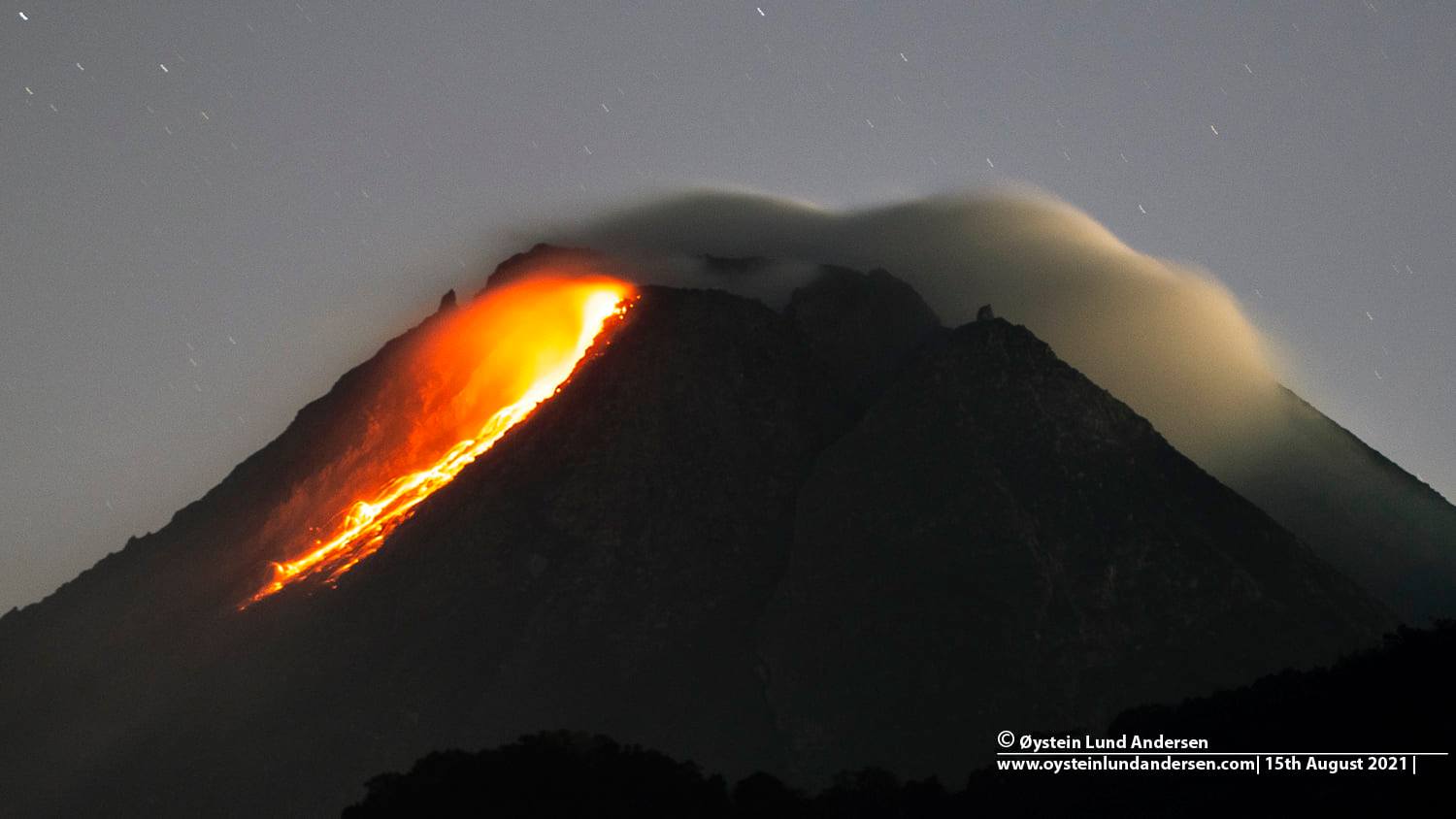
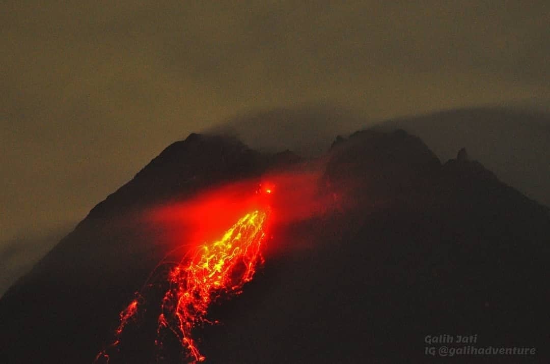
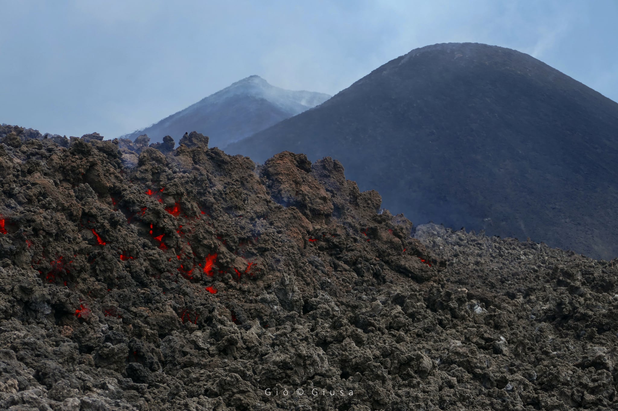
August 23 , 2021. EN. Italy : Stromboli , Russia / Northern Kurils : Chirinkotan , Indonesia : Ili Lewotolok , Ecuador : Reventador , Indonesia : Lokon-Empung , Costa Rica : Turrialba / Poas .

August 23 , 2021.


Italy , Stromboli :

During this break, very welcome in the activity of Etna, the Stromboli continues to do its usual activity, which consists of small ′ ′ strombolian explosions, punctuated by pauses ranging from a few seconds to tens of minutes (rarely hours), These explosions launch scraps of incandescent lava up to a few tens of meters, sometimes even 100-200 m high. This is the normal classical activity of Stromboli which can go through more and less intense phases with a number active mouths that can vary from 3-4 to more than 10. The mouths are concentrated in two large areas on the ′ ′ Terrace of the craters, the North crater area and the Center-South area.

After two stronger explosions on July 14 and 28, 2021, Stromboli activity is currently at a fairly modest level, and what we see in this video is not as significant as it might seem. We see a ′ ′ hornito ′ ′ which, at the start of the explosion, launches the cooling crust formed on the magma into its conduit before the magma itself begins to decompress and splash in the air, throwing shreds of washes fluids up to about 70 m high. It was the morning of August 19, 2021, I was 290 m above sea level on the north side of the Sciara del Fuoco.

Source et vidéo : Boris Behncke.


Russia / Northern Kurils , Chirinkotan :

VOLCANO OBSERVATORY NOTICE FOR AVIATION (VONA)

Issued: August 23 , 2021
Volcano: Chirinkotan (CAVW #290260)
Current aviation colour code: ORANGE
Previous aviation colour code: orange
Source: KVERT
Notice Number: 2021-100
Volcano Location: N 48 deg 58 min E 153 deg 28 min
Area: Northern Kuriles, Russia
Summit Elevation: 724 m (2374.72 ft)

Volcanic Activity Summary:
The moderate ash emission from the volcano continues. Satellite data show an ash plume is extending for 126 km to the west of the volcano.
This activity continues. Ash explosions up to 10-15 km (32,800-49,200 ft) a.s.l. could occur at any time. Ongoing activity could affect international and low-flying aircraft.

Volcanic cloud height:
1200-1500 m (3936-4920 ft) AMSL Time and method of ash plume/cloud height determination: 20210823/0420Z – Himawari-8

Other volcanic cloud information:
Distance of ash plume/cloud of the volcano: 126 km (78 mi)
Direction of drift of ash plume/cloud of the volcano: W / azimuth 261 deg
Time and method of ash plume/cloud determination: 20210823/0420Z – Himawari-8
Start time of explosion and how determined: 20210822/2235Z – Satellite data

Source et photo : Kvert.


Indonesia , Ili Lewotolok :

VOLCANO OBSERVATORY NOTICE FOR AVIATION – VONA

Issued : August 22 , 2021
Volcano : Ili Lewotolok (264230)
Current Aviation Colour Code : ORANGE
Previous Aviation Colour Code : orange
Source : Ili Lewotolok Volcano Observatory
Notice Number : 2021LEW35
Volcano Location : S 08 deg 16 min 19 sec E 123 deg 30 min 18 sec
Area : East Nusa Tenggara, Indonesia
Summit Elevation : 4554 FT (1423 M)

Volcanic Activity Summary :
Eruption with volcanic ash cloud at 04h44 UTC (12h44 local). Eruption and ash emission is not continuing.

Volcanic Cloud Height :
Best estimate of ash-cloud top is around 9354 FT (2923 M) above sea level, may be higher than what can be observed clearly. Source of height data: ground observer.

Other Volcanic Cloud Information :
Ash-cloud moving to West

Remarks :
Seismic activity is characterized by continuous volcanic tectonic Earthquake.

Level III activity level (Siaga) since November 29, 2020 at 1:00 p.m. WITA. This increase in status was motivated by an eruption on November 27, 2020 at 05:57 a.m. WITA with a height of gray / black ash columns observed at 500 m above the peak (1,923 m altitude) with a strong intensity, oriented to the west. This eruption was recorded on a seismogram with a maximum amplitude of 34 mm. Eruptions still occur today.
The volcano was clearly visible until it was covered in fog. The smoke from the crater is white, gray / black with moderate to strong intensity, about 50-1500 meters above the summit. The weather is sunny to cloudy, the wind is weak to the West and North-West. The air temperature is approximately 21.5 to 32.1 ° C. Humidity 59.7-77.4%. An eruption earthquake was recorded, but visually the height of the eruption and the color of the ash was not observed.

According to the seismographs of August 22, 2021, it was recorded:
An eruption earthquake
15 earthquakes of emissions
6 harmonic tremors
1 non-harmonic tremor
1 local tectonic earthquake
1 distant tectonic earthquake

Source : PVMBG.

Photo : Jeffry Pugel /PVMBG – Magma Indonesia.


Ecuador , Reventador :

DAILY REPORT OF THE STATE OF THE REVENTADOR VOLCANO, Sunday August 22, 2021.
Information Geophysical Institute – EPN.

Surface activity level: High, Surface trend: No change.
Internal activity level: Moderate, Internal trend: No change.

Seismicity: From August 21, 2021, 11: 00h to August 22, 2021, 11: 00h:

Explosions (EXP): 45 events
Long period type events (LP): 38
Tremors of emissions (TREMI): 4.


Rains / lahars: No rains were recorded in the area.

Emission / ash column: Yesterday afternoon, several ash emissions were observed, the most important exceeding 1000 m, oriented in a north-west direction. The Washington VAAC reported 2 ash emissions that reached 988 m with a West and Northwest direction

Other monitoring parameters: Neither FIRMS nor MIROVA have recorded any thermal anomalies on the Reventador during the last 24 hours.

Observations: During the night so far most of the time the area has remained cloudy.

Alert level: Orange.

Source et photo : IG-EPN


Indonesia , Lokon-Empung :

Mount Lokon is off limits to tourists due to a potential eruption.

The Regional Disaster Mitigation Agency (BPBD) in the town of Tomohon, North Sulawesi, has closed climbing activities on Mount Lokon which is still on Level II or Waspada alert.

« The city government will certainly follow through on the recommendations of the volcano lookout post by stepping up security at the entrance gates to Mount Lokon, » Tomohon Regional Secretary Edwin Roring said on Sunday (August 22nd).

The Volcanic and Geological Risk Mitigation Center (PVMBG) has called on the public and tourists to stay away from the crater following an increase in shallow earthquakes that could trigger eruptions.

The twin volcanoes Lokon and Empung, rising about 800 m above the plain of Tondano, are among the most active volcanoes of Sulawesi. Lokon, the higher of the two peaks (whose summits are only 2 km apart), has a flat, craterless top. The morphologically younger Empung volcano to the NE has a 400-m-wide, 150-m-deep crater that erupted last in the 18th century, but all subsequent eruptions have originated from Tompaluan, a 150 x 250 m wide double crater situated in the saddle between the two peaks. Historical eruptions have primarily produced small-to-moderate ash plumes that have occasionally damaged croplands and houses, but lava-dome growth and pyroclastic flows have also occurred. A ridge extending WNW from Lokon includes Tatawiran and Tetempangan peak, 3 km away.

Sources : TEMPO.CO / Tomohon , GVP.

Photo : WIkimapia .


Costa Rica , Turrialba / Poas :

Turrialba volcano

No eruption is reported.
Seismic activity is similar, compared to yesterday.
At the time of this report, the winds are blowing north.
Passive degassing is maintained without eruptive activity.
Frequent volcanic earthquakes of low frequency and amplitudes between low and medium are observed.
The SO2 concentration measured by the MultiGAS station was stable.
There was a slight decrease in the CO2 / SO2 ratio, from ~ 20 in the previous days to ~ 17 in the last measurement on August 19.
No significant deformation of the volcanic building is observed.

Poas volcano

No eruption is reported.
Seismic activity is similar, compared to yesterday.
At the time of this report, the winds are blowing from the west.
A fumarolic activity is recorded on the eastern wall of the active crater.
Passive degassing and thermal convection (bubbles associated with underwater fumaroles) are maintained to the south of the lake, without eruptive activity.
Low frequency and low amplitude volcanic earthquakes are recorded.
The CO2 / SO2 ratio shows a small increase to ~ 4 values on August 19.
No significant deformation of the volcanic building is observed.

Source : Ovsicori.

Photo : Poas , RSN, Jean Paul Calvo.

23 Aout 2021. FR. Italie : Stromboli , Russie / Kouriles du Nord : Chirinkotan , Indonésie : Ili Lewotolok , Equateur : Reventador , Indonésie : Lokon-Empung , Costa Rica : Turrialba / Poas .

23 Aout 2021.


Italie , Stromboli :

Pendant cette pause, très bienvenue dans l’activité de l’Etna, le Stromboli continue de faire son activité habituelle, qui consiste en de petites explosions ′′ stromboliennes « , rythmées par des pauses allant de quelques secondes à des dizaines de minutes (rarement des heures), Ces explosions lancent des lambeaux de lave incandescente jusqu’à quelques dizaines de mètres, parfois même 100-200 m de haut. Ceci est l’activité classique normale du Stromboli qui peut traverser des phases plus et moins intenses avec un nombre de bouches actives pouvant varier de 3-4 à plus de 10. Les bouches sont concentrées dans deux grandes zones sur la ′′ Terrasse des cratères « , la zone des cratères Nord et la zone Centre-Sud.

Après deux explosions plus fortes survenues les 14 et 28 juillet 2021, l’activité du Stromboli est actuellement à un niveau assez modeste, et ce que l’on voit dans cette vidéo n’est pas aussi important qu’il ne peut le paraître. On voit un ′′ hornito ′′ qui, au début de l’explosion, lance la croûte de refroidissement formée sur le magma dans son conduit avant que le magma lui-même ne commence à décompresser et éclabousser dans les airs, projetant des lambeaux de lave fluides jusqu’à environ 70 m de haut. C ‘ était le matin du 19 août 2021, je me trouvais à 290 m d’altitude sur le côté Nord de la Sciara del Fuoco.

Source et vidéo : Boris Behncke.


Russie / Kouriles du Nord , Chirinkotan :

AVIS D’OBSERVATION DU VOLCAN POUR L’AVIATION (VONA)

Date d’émission : 23 août 2021
Volcan : Chirinkotan (CAVW #290260)
Code couleur aviation actuel : ORANGE
Code couleur aviation précédent : orange
Source : KVERT
Numéro d’avis : 2021-100
Emplacement du volcan : N 48 deg 58 min E 153 deg 28 min
Région : Kouriles du Nord, Russie
Altitude du sommet : 724 m (2374,72 pi)

Résumé de l’activité volcanique :
L’émission modérée de cendres sur le volcan se poursuit. Les données satellitaires montrent qu’un panache de cendres s’étend sur 126 km à l’Ouest du volcan.
Cette activité se poursuit. Des explosions de cendres jusqu’à 10-15 km (32 800-49 200 pieds) d’altitude pourraient survenir à tout moment. L’activité en cours pourrait affecter les aéronefs internationaux volant à basse altitude.

Hauteur des nuages ​​volcaniques :
1200-1500 m (3936-4920 ft) AMSL Heure et méthode de détermination de la hauteur du panache de cendres/du nuage : 20210823/0420Z – Himawari-8

Autres informations sur les nuages ​​volcaniques :
Distance du panache de cendres/nuage du volcan : 126 km (78 mi)
Direction de dérive du panache de cendres/nuage du volcan : W / azimut 261 deg
Heure et méthode de détermination du panache de cendres/nuage : 20210823/0420Z – Himawari-8
Heure de début de l’explosion et mode de détermination : 20210822/2235Z – Données satellitaires.

Source et photo : Kvert.


Indonésie , Ili Lewotolok :

AVIS D’OBSERVATION DU VOLCAN POUR L’AVIATION – VONA

Émis : 22 août 2021
Volcan : Ili Lewotolok (264230)
Code Couleur Aviation Actuel : ORANGE
Code Couleur Aviation précédent : orange
Source : Observatoire du volcan Ili Lewotolok
Numéro d’avis : 2021LEW35
Emplacement du volcan : S 08 deg 16 min 19 sec E 123 deg 30 min 18 sec
Zone : East Nusa Tenggara, Indonésie
Altitude du sommet : 4554 FT (1423 M)

Résumé de l’activité volcanique :
Eruption avec nuage de cendres volcaniques à 04h44 UTC (12h44 local). L’éruption et l’émission de cendres ne se poursuivent pas.

Hauteur des nuages volcaniques :
La meilleure estimation du sommet du nuage de cendres est d’environ 9354 FT (2923 M) au-dessus du niveau de la mer, peut être plus élevée que ce qui peut être observé clairement. Source des données de hauteur : observateur au sol.

Autres informations sur les nuages volcaniques :
Nuage de cendres se déplaçant vers l’Ouest

Remarques :
L’activité sismique est caractérisée par des tremblements de terre tectoniques volcaniques continus.

Niveau d’activité de Niveau III (Siaga) depuis le 29 novembre 2020 à 13h00 WITA. Cette augmentation de statut avait été motivée par une éruption le 27 novembre 2020 à 05h57 WITA avec une hauteur de colonnes de cendres grises / noires observées à 500 m au-dessus du pic (1 923 m d’altitude) avec une intensité forte , orientée vers l’Ouest. Cette éruption avait été enregistrée sur un sismogramme d’une amplitude maximale de 34 mm . Des éruptions se produisent encore aujourd’hui.
Le volcan était clairement visible jusqu’à ce qu’il soit recouvert de brouillard. La fumée issue du cratère est blanche, grise / noire avec une intensité modérée à forte, à environ 50-1500 mètres au dessus du sommet. Le temps est ensoleillé à nuageux, le vent est faible à l’Ouest et au Nord-Ouest. La température de l’air est d’environ 21,5 à 32,1°C. Humidité 59,7-77,4%. Un tremblement de terre d’éruption a été enregistré, mais visuellement la hauteur de l’éruption et la couleur des cendres n’ont pas été observées.

Selon les sismographes du 22 août 2021, il a été enregistré :
Un tremblement de terre d’éruption  
15 tremblements de terre d’émissions
6 tremors harmoniques
1 tremor non harmonique  
1 séisme tectonique local
1 séisme tectonique lointain

Source : PVMBG.

Photo : Jeffry Pugel /PVMBG – Magma Indonesia.


Equateur , Reventador :

RAPPORT QUOTIDIEN DE L’ETAT DU VOLCAN REVENTADOR , Dimanche 22 Aout 2021.
Information Geophysical Institute – EPN.

Niveau d’activité Superficiel: Haut , Tendance de surface : Pas de changement .
Niveau d’activité interne: Modéré , Tendance interne : Pas de changement.

Sismicité : Du 21 Aout 2021, 11:00h au 22 Aout  2021, 11:00h : 

Explosions (EXP): 45 événements
Evénements de type longue période ( LP ): 38
Tremors d’émissions ( TREMI) : 4.


Pluies / lahars: Il n’a pas été enregistré de pluies dans le secteur .

Emission / colonne de cendres: Hier après-midi, plusieurs émissions de cendres ont été observées, la plus importante dépassant les 1000 m , orientée dans une direction Nord-Ouest. Le VAAC de Washington a signalé 2 émissions de cendres qui ont atteint 988 m avec une direction Ouest et Nord-Ouest

Autres paramètres de surveillance: Ni FIRMS ni MIROVA n’ont enregistré d’anomalies thermiques sur le Reventador au cours des dernières 24 heures.

Observations: Pendant la nuit jusqu’à présent la plupart du temps le secteur est resté nuageux.

Niveau d’alerte: Orange.

Source et photo : IG-EPN


Indonésie , Lokon-Empung :

Le Mont Lokon interdit aux touristes en raison d’une éruption potentielle.

L’Agence régionale d’atténuation des catastrophes (BPBD) de la ville de Tomohon, au Nord de Sulawesi, a fermé les activités d’escalade sur le mont Lokon qui est toujours en état d’alerte de niveau II ou Waspada.

« Le gouvernement de la ville donnera certainement suite aux recommandations du poste d’observation du volcan en renforçant la sécurité aux portes d’entrée du mont Lokon », a déclaré le secrétaire régional de Tomohon, Edwin Roring dimanche 22 août.

Le Centre d’atténuation des risques volcaniques et géologiques (PVMBG) a appelé au public et aux touristes à ne pas s’approcher du cratère suite à une augmentation des tremblements de terre peu profonds qui pourraient déclencher des éruptions  .

Les volcans jumeaux Lokon et Empung, s’élevant à environ 800 m au-dessus de la plaine de Tondano, sont parmi les volcans les plus actifs de Sulawesi. Le Lokon, le plus élevé des deux sommets (dont les sommets ne sont distants que de 2 km), a un sommet plat et sans cratère. Le volcan Empung morphologiquement plus jeune au Nord-Est possède un cratère de 400 m de large et de 150 m de profondeur qui est entré en éruption pour la dernière fois au 18ème siècle, mais toutes les éruptions ultérieures sont originaires du Tompaluan, un double cratère de 150 x 250 m de large situé dans le selle entre les deux sommets. Les éruptions historiques ont principalement produit des panaches de cendres petits à modérés qui ont parfois endommagé les terres cultivées et les maisons, mais la croissance de dômes de lave et des coulées pyroclastiques se sont également produites. Une crête s’étendant l’Ouest Nord Ouest du Lokon comprend les pics Tatawiran et Tetempangan, à 3 km.

Sources : TEMPO.CO / Tomohon , GVP.

Photo : WIkimapia .


Costa Rica , Turrialba / Poas :

Volcan Turrialba

Aucune éruption n’est signalée.
L’activité sismique est similaire, par rapport à hier.
Au moment de ce rapport, les vents soufflent vers le Nord.
Un dégazage passif est maintenu sans activité éruptive.
Des séismes volcaniques fréquents de basse fréquence et d’amplitudes entre faible et moyenne sont observés.
La concentration de SO2 mesurée par la station MultiGAS était stable.
Il y a eu une légère diminution du rapport CO2 / SO2, de ~ 20 les jours précédents à ~ 17 lors de la dernière mesure du 19 août.
Aucune déformation significative du bâtiment volcanique n’est observée.

Volcan Poas

Aucune éruption n’est signalée.
L’activité sismique est similaire, par rapport à hier.
Au moment de ce rapport, les vents soufflent à l’Ouest.
Une activité fumerolienne est enregistrée sur la paroi orientale du cratère actif.
Le dégazage passif et la convection thermique (bulles associées aux fumerolles sous-marines) sont maintenus au Sud du lac, sans activité éruptive.
Des séismes volcaniques de basse fréquence et de faible amplitude sont enregistrés.
Le ratio CO2 / SO2 montre une petite augmentation à ~ 4 valeurs le 19 août.
Aucune déformation significative du bâtiment volcanique n’est observée.

Source : Ovsicori.

Photo : Poas , RSN, Jean Paul Calvo.

August 16, 2021. EN. Alaska : Semisopochnoi , Philippines : Taal , Indonesia : Merapi , Russia / Northern Kurils : Chirinkotan , Chile : Nevados de Chillan .

August 16 , 2021.


Alaska , Semisopochnoi :

51°55’44 » N 179°35’52 » E,
Summit Elevation 2625 ft (800 m)
Current Volcano Alert Level: WATCH
Current Aviation Color Code: ORANGE

Activity at the north crater of Mount Cerberus on Semisopochnoi Island continues. Over the past day, several explosions and occasionally strong seismic tremor have characterized the seismicity. Low-level ash emissions were observed in satellite and web camera images over the past day. Ash fall is likely occurring on parts of Semisopochnoi Island.

North Cerberus Crater, June 6, 2021. Taken by Ellie Boyce on a helicopter flight back to Steadfast from CERB. « There was less vapor in the crater than on Hannah’s FLIR flight last week and we were able to see all the way to the bottom where there still appears to be a small lake on one side (in the attached photo , just to the right of the brightest spot of vapor). « 

Small eruptions producing minor ash deposits within the vicinity of the active north crater of Mount Cerberus and ash clouds under 10,000 feet above sea level have characterized the recent activity and show no signs of abating. Small explosions may continue and could be difficult to detect especially during poor weather conditions.

Semisopochnoi is monitored by local seismic and infrasound sensors, satellite data, web cameras, and remote infrasound and lightning networks.

Source : AVO.

Photo : Boyce, Ellie / Alaska Volcano Observatory / University of Alaska Fairbanks, Geophysical Institute.


Philippines , Taal :

TAAL VOLCANO BULLETIN 16 August 2021 8:00 AM

In the past 24-hour period, the Taal Volcano Network recorded seventy-four (74) volcanic tremor events having durations of one (1) to twenty (20) minutes and low-level background tremor that has persisted since 07 July 2021. Activity at the Main Crater was dominated by upwelling of hot volcanic fluids in its lake which generated plumes 1,800 meters tall that drifted south-southwest and northeast.


Sulfur dioxide (SO2) emission averaged 5,675 tonnes/day on 15 August 2021. In addition, vog was observed over Taal Volcano and vicinity. Based on ground deformation parameters from electronic tilt, continuous GPS and InSAR monitoring, Taal Volcano Island has begun deflating in April 2021 while the Taal region continues to undergo very slow extension since 2020.

Source : Phivolcs.


Indonesia , Merapi :

VOLCANO OBSERVATORY NOTICE FOR AVIATION – VONA

Issued : August 15 , 2021
Volcano : Merapi (263250)
Current Aviation Colour Code : ORANGE
Previous Aviation Colour Code : orange
Source : Merapi Volcano Observatory
Notice Number : 2021MER06
Volcano Location : S 07 deg 32 min 31 sec E 110 deg 26 min 31 sec
Area : Special Region of Yogyakarta, Indonesia
Summit Elevation : 9498 FT (2968 M)

Volcanic Activity Summary :
Eruption with volcanic ash cloud at 22h53 UTC (05h53 local). Eruption and ash emission has stopped.

Volcanic Cloud Height :
Best estimate of ash-cloud top is around 11418 FT (3568 M) above sea level, may be higher than what can be observed clearly. Source of height data: ground observer.

Other Volcanic Cloud Information :
Ash-cloud generated by pyroclastic density current moving to the west.

Remarks :
PDC was recorded on a seismogram with a maximum amplitude of 66 mm and 289 seconds duration. Run out distance 3.500 km to southwest.

Level of activity at level III (SIAGA) since November 5, 2020 at 12 p.m. WIB. The Merapi volcano (2,968 m above sea level) erupts intermittently.
The volcano is clearly visible until it is covered in fog. The smoke observable from the main crater is white with a fine to moderate intensity about 50 meters from the summit. The weather is sunny to cloudy, winds are light to moderate in the southwest, west and northwest. The air temperature is around 11-29 ° C. Humidity 41-87%. Atmospheric pressure 617-946 mmHg. There was a hot avalanche cloud with a sliding distance of 2000 m to the southwest. Avalanches of incandescent lava were observed with a maximum slide distance of 1,500 m to the southwest.

According to the seismographs of August 15, 2021, it was recorded:
1 Avalanche hot cloud earthquake
231 avalanche earthquakes
12 emissions earthquake
2 low frequency earthquakes
68 hybrid / multi-phase earthquakes
10 shallow volcanic earthquakes.

Source : Magma Indonésie , PVMBG.

Photos : Øystein Lund Andersen .


Russia / Northern Kurils , Chirinkotan :

VOLCANO OBSERVATORY NOTICE FOR AVIATION (VONA)

Issued: August 16 , 2021
Volcano: Chirinkotan (CAVW #290260)
Current aviation colour code: ORANGE
Previous aviation colour code: orange
Source: KVERT
Notice Number: 2021-92
Volcano Location: N 48 deg 58 min E 153 deg 28 min
Area: Northern Kuriles, Russia
Summit Elevation: 724 m (2374.72 ft)

Volcanic Activity Summary:
The moderate eruptive activity of the volcano continues. The explosive event of the volcano began at 23:10 UTC on 15 August. Ash cloud is drifting about 23 km to the east from the volcano.
The moderate eruptive activity of the volcano continues. Ash explosions up to 10-15 km (32,800-49,200 ft) a.s.l. could occur at any time. Ongoing activity could affect international and low-flying aircraft.

Volcanic cloud height:
3500-4500 m (11480-14760 ft) AMSL Time and method of ash plume/cloud height determination: 20210816/0030Z – Himawari-8

Other volcanic cloud information:
Distance of ash plume/cloud of the volcano: 23 km (14 mi)
Direction of drift of ash plume/cloud of the volcano: E / azimuth 82 deg
Time and method of ash plume/cloud determination: 20210816/0030Z – Himawari-8
Start time of explosion and how determined: 20210815/2310Z – Satellite data

Source et photo : Kvert.


Chile , Nevados de Chillan :

Special Report on Volcanic Activity (REAV), Ñuble Region, Nevados de Chillán Volcanic Complex, August 15, 2021, 17:20 local time (Continental Chile).

The National Service of Geology and Mines of Chile (Sernageomin) publishes the following PRELIMINARY information, obtained thanks to the monitoring equipment of the National Volcanic Surveillance Network (RNVV), processed and analyzed at the Volcanological Observatory of the Southern Andes (Ovdas) :

On Sunday August 15 at 4.30 p.m. local time (8.30 p.m. UTC), monitoring stations installed in the vicinity of the Nevados de Chillán volcanic complex recorded an earthquake associated with fluid dynamics inside the volcanic system (Long type Period).

The characteristics of the earthquake after its analysis are as follows:
TIME OF ORIGIN: 4:30 p.m. local time (8:30 p.m. UTC)
LATITUDE: 36.862 ° S
LONGITUDE: 71.381 ° W
DEPTH: 0.2 km
REDUCED DISPLACEMENT: 523 (cm * cm)

OBSERVATIONS:
No surface activity is observed due to weather conditions.

The volcanic technical alert remains at the Yellow level.

Source : Sernageomin.

Photo : Ingemmet.

16 Aout 2021. FR. Alaska : Semisopochnoi , Philippines : Taal , Indonésie : Merapi , Russie / Kouriles du Nord : Chirinkotan , Chili : Nevados de Chillan .

16 Aout 2021.


Alaska , Semisopochnoi :

51°55’44 » N 179°35’52 » Est,
Élévation du sommet : 2625 pi (800 m)
Niveau d’alerte volcan actuel : ATTENTION
Code couleur aviation actuel : ORANGE

L’activité du cratère Nord du mont Cerberus sur l’île Semisopochnoi se poursuit. Au cours de la dernière journée, plusieurs explosions et parfois de fortes secousses sismiques ont caractérisé la sismicité. Des émissions de cendres de faible niveau ont été observées dans les images des satellites et des caméras Web au cours de la dernière journée. Des chutes de cendres se produisent probablement sur certaines parties de l’île Semisopochnoi.

Cratère North Cerberus, 6 juin 2021. Prise par Ellie Boyce lors d’un vol en hélicoptère de retour à Steadfast depuis le CERB. « Il y avait moins de vapeur dans le cratère que lors du vol FLIR d’Hannah la semaine dernière et nous avons pu voir jusqu’au fond où il semble encore y avoir un petit lac d’un côté (sur la photo ci-jointe, juste à droite du la plus brillante tache de vapeur). »

De petites éruptions produisant des dépôts de cendres mineurs à proximité du cratère Nord actif du mont Cerberus et des nuages de cendres à moins de 10 000 pieds au-dessus du niveau de la mer ont caractérisé l’activité récente et ne montrent aucun signe de ralentissement. De petites explosions peuvent se poursuivre et pourraient être difficiles à détecter, en particulier par mauvais temps.

Le Semisopochnoi est surveillé par des capteurs sismiques et infrasons locaux, des données satellitaires, des caméras Web et des réseaux distants de capteurs d’infrasons et de foudre.

Source : AVO.

Photo : Boyce, Ellie / Alaska Volcano Observatory / University of Alaska Fairbanks, Geophysical Institute.


Philippines , Taal :

BULLETIN D’ACTIVITE DU VOLCAN TAAL 16 août 2021 8:00 AM

Au cours des dernières 24 heures, le réseau de capteurs du volcan Taal a enregistré soixante-quatorze (74) événements de tremor volcanique d’une durée d’une (1) à vingt (20) minutes et un tremor de fond de faible niveau qui a persisté depuis le 7 juillet 2021. L’activité du cratère principal était dominée par une remontée de fluides volcaniques chauds dans son lac qui a généré des panaches de 1 800 mètres de haut qui ont dérivé vers le Sud-Sud-Ouest et le Nord-Est.


Les émissions de dioxyde de soufre (SO2) étaient en moyenne de 5 675 tonnes/jour le 15 août 2021. De plus, du vog a été observé sur le volcan Taal et ses environs. Sur la base des paramètres de déformation du sol provenant de l’inclinaison électronique, de la surveillance continue du GPS et de l’InSAR, l’île du volcan Taal a commencé à se dégonfler en avril 2021 tandis que la région de Taal continue de subir une extension très lente depuis 2020.

Source : Phivolcs.


Indonésie , Merapi :

AVIS D’OBSERVATION DU VOLCAN POUR L’AVIATION – VONA

Émis : 15 août 2021
Volcan : Merapi (263250)
Code Couleur Aviation Actuel : ORANGE
Code Couleur Aviation précédent : orange
Source : Observatoire du volcan Merapi
Numéro d’avis : 2021MER06
Emplacement du volcan : S 07 deg 32 min 31 sec E 110 deg 26 min 31 sec
Zone : Région spéciale de Yogyakarta, Indonésie
Altitude du sommet : 9498 FT (2968 M).

Résumé de l’activité volcanique :
Eruption avec nuage de cendres volcaniques à 22h53 UTC (05h53 locale). L’éruption et l’émission de cendres ont cessé.

Hauteur des nuages volcaniques :
La meilleure estimation du sommet du nuage de cendres est d’environ 11418 FT (3568 M) au-dessus du niveau de la mer, peut être plus élevée que ce qui peut être clairement observé. Source des données de hauteur : observateur au sol.

Autres informations sur les nuages volcaniques :
Nuage de cendres généré par un courant de densité pyroclastique se déplaçant vers l’Ouest.

Remarques :
Le courant de densité pyroclastique a été enregistré sur un sismogramme avec une amplitude maximale de 66 mm et une durée de 289 secondes. Glissement sur une distance de 3.500 m au Sud-Ouest.

Niveau d’activité de niveau III (Veille) depuis le 5 novembre 2020 à 12h00 WIB. Le volcan Merapi (2 968 m d’altitude) entre en éruption par intermittence.
Le volcan est clairement visible jusqu’à ce qu’il soit recouvert de brouillard. La fumée observable du cratère principal est blanche avec une intensité fine à modérée à environ 50 mètres du sommet. Le temps est ensoleillé à nuageux, les vents sont faibles à modérés au sud-ouest, à l’ouest et au nord-ouest. La température de l’air est d’environ 11-29°C. Humidité 41-87%. Pression atmosphérique 617-946 mmHg. Il y avait un nuage chaud d’avalanches avec une distance de glissement de 2 000 m au sud-ouest. Des avalanches de lave incandescente ont été observées avec une distance de glissement maximale de 1 500 m vers le sud-ouest.

Selon les sismographes du 15 août 2021, il a été enregistré :
1 tremblement de terre de nuage chaud d’Avalanche 
231 tremblements de terre d’avalanches
12 tremblement de terre d’émissions
2 tremblements de terre basses fréquences
68 séismes hybrides/multi-phases
10 tremblements de terre volcaniques peu profonds.

Source : Magma Indonésie , PVMBG.

Photos : Øystein Lund Andersen .


Russie / Kouriles du Nord , Chirinkotan :

AVIS D’OBSERVATION DU VOLCAN POUR L’AVIATION (VONA)

Date d’émission : 16 août 2021
Volcan : Chirinkotan (CAVW #290260)
Code couleur aviation actuel : ORANGE
Code couleur aviation précédent : orange
Source : KVERT
Numéro d’avis : 2021-92
Emplacement du volcan : N 48 deg 58 min E 153 deg 28 min
Région : Kouriles du Nord, Russie
Altitude du sommet : 724 m (2374,72 pi)

Résumé de l’activité volcanique :
L’activité éruptive modérée du volcan se poursuit. Un événement explosif du volcan a commencé à 23h10 UTC le 15 août. Un nuage de cendres dérive à environ 23 km à l’Est du volcan.
Cette activité se poursuit. Des explosions de cendres jusqu’à 10-15 km (32 800-49 200 pieds) d’altitude pourraient survenir à tout moment. L’activité en cours pourrait affecter les aéronefs internationaux volant à basse altitude.

Hauteur des nuages ​​volcaniques :
3500-4500 m (11480-14760 ft) AMSL Heure et méthode de détermination de la hauteur du panache de cendres/nuage : 20210816/0030Z – Himawari-8

Autres informations sur les nuages ​​volcaniques :
Distance du panache de cendres/nuage du volcan : 23 km (14 mi)
Direction de dérive du panache de cendres/nuage du volcan : E / azimut 82 deg
Heure et méthode de détermination du panache de cendres/nuage : 20210816/0030Z – Himawari-8
Heure de début de l’explosion et mode de détermination : 20210815/2310Z – Données satellitaires

Source et photo : Kvert.


Chili , Nevados de Chillan :

Rapport spécial sur l’activité volcanique (REAV) , Région de Ñuble, Complexe volcanique Nevados de Chillán , 15 août 2021, 17:20 Heure locale (Chili continental).

Le Service national de géologie et des mines du Chili (Sernageomin) publie les informations PRELIMINAIRE suivantes , obtenu grâce aux équipements de surveillance du Réseau National de Surveillance Volcanique (RNVV), traitées et analysées à l’Observatoire volcanologique des Andes du Sud (Ovdas) :

Le dimanche 15 août à 16h30 heure locale (20h30 UTC), les stations de surveillance installées dans les environs du complexe volcanique du Nevados de Chillán ont enregistré un tremblement de terre associé à la dynamique des fluides à l’intérieur du système volcanique (type Longue Période).

Les caractéristiques du séisme après son analyse sont les suivantes :
HEURE D’ORIGINE : 16h30 heure locale (20h30 UTC)
LATITUDE : 36,862 ° S
LONGITUDE: 71,381 ° W
PROFONDEUR : 0,2 km
DÉPLACEMENT RÉDUIT : 523 (cm * cm)

OBSERVATIONS :
Aucune activité de surface n’est observée en raison des conditions météorologiques.

L’alerte technique volcanique reste au niveau Jaune.

Source : Sernageomin.

Photo : Ingemmet.

August 14, 2021. EN. Japan : Fukutoku-Okanoba , Indonesia : Merapi , Alaska : Great Sitkin , Kamchatka : Chirinkotan , Saint Vincent : Soufrière Saint Vincent , Ecuador : Reventador .

August 14 , 2021.


Japan , Fukutoku-Okanoba :

The Japan Meteorological Agency has confirmed that the submarine volcano in Japan’s Ogasawara Islands erupted today (the 13th). This is the first eruption in 11 years. The Japan Meteorological Agency continues to issue volcanic eruption warnings. Taiwan’s meteorological director Zheng Mingdian revealed on Facebook « The smoke has reached the peak of the tropopause. » According to a report by Japan’s « NHK », the Japan Meteorological Agency pointed out that at approximately 6:20 a.m. Japan time on the 13th (approximately 5:20 a.m. Taiwan time on the 13th), a weather satellite captured a photo of the seabed at approximately 50 kilometers south of Iwo Jima, Japan. The « Fukutoku-Okanoba » volcano has erupted. From the satellite image, we can see that white smoke is emerging from the scene, which is constantly drifting west. As a result, the Meteorological Agency issued an eruption warning. In June, the Japanese Coast Guard observed that the surrounding sea surface had changed color, confirming that local volcanic activity had become more active. Zheng Mingdian posted a satellite image of the cloud that has reached the tropopause on Facebook.

Date: August 13, 2021
VAAC: TOKYO
VOLCANO: FUKUTOKU-OKA-NO-BA
PSN: N2417 E14129
ZONE: JAPAN
SUMMIT ALTITUDE: -29 M
NOTICE N °: 2021/4
SOURCE OF INFO: HIMAWARI-8
AVIATION COLOR CODE: NIL
ERUPTION DETAILS: EMISSIONS WILL CONTINUE

Fukutoku-Oka-no-ba is a submarine volcano located 5 km NE of the pyramidal island of Minami-Ioto. Water discoloration is frequently observed from the volcano, and several ephemeral islands have formed in the 20th century. The first of these formed Shin-Ioto (« New Sulfur Island ») in 1904, and the most recent island was formed in 1986. The volcano is part of an elongated edifice with two major topographic highs trending NNW-SSE, and is a trachyandesitic volcano geochemically similar to Ioto.

Sources : news.ltn.com.tw ,VAAC Tokyo , GVP.

Photo : Gardes Côtes Japonais via Sherine France.


Indonesia , Merapi :

Mount Merapi activity report from August 5 to 12, 2021

OBSERVATION RESULTS
Visual
The weather around Mount Merapi is generally sunny in the morning and evening, while it is foggy in the afternoon. White, weak to thick, low pressure, 600m high fumes were observed from Mount Merapi de Selo observation post on August 7, 2021 at 10:00 a.m. WIB.
This week, there were 28 hot avalanche clouds to the southwest with a maximum slide distance of 3000 m. Lava avalanches were observed 252 times southwest with a maximum slide distance of 2000 m and 1 time southeast with a slide distance of 500 m.
Ash rains were reported in several areas, including August 10-12, 2021, including Dukun, Sawangan, Grabag, Pakis, Tegalrejo, Secang, Srumbung, Salam, Muntilan and Mungkid districts.
It was observed that there were morphological changes in the southwest lava dome and central dome due to increased avalanche activity and hot avalanche clouds this week. The volume of the lava dome is relatively fixed.

Seismicity
This week, the seismicity of Mount Merapi recorded
28 hot cloud avalanche earthquakes (PA),
334 shallow volcanic earthquakes (VTB),
10 low frequency earthquakes (LF),
1,296 multi-phase earthquakes (MP),
2,021 avalanche earthquakes (RF),
141 emission earthquakes (DG),
19 tectonic earthquakes (TT).
The intensity of this week’s earthquake is still quite high.

Deformation
The deformation of Mount Merapi, which was monitored using EDM this week, showed a distance shortening rate of 7.7 cm / day.

Rain and lahars
This week, there have been no reports of rain, lahars or additional flow in the rivers that originate on Mount Merapi.

Conclusion
Based on the results of visual and instrumental observations, it is concluded that:
The volcanic activity of Mount Merapi is still quite high in the form of effusive eruption activity. The status of the activity is defined in the “SIAGA” level.

Source : BPPTKG.

Photos : Yohannes Tyas Galih Jati


Alaska , Great Sitkin :

52°4’35 » N 176°6’39 » W,
Summit Elevation 5709 ft (1740 m)
Current Volcano Alert Level: WATCH
Current Aviation Color Code: ORANGE

Eruption of a lava dome in the summit crater of Great Sitkin Volcano continued over the last week. Satellite data showed that the dome grew from approximately 300 m diameter on August 6 to around 380 m on August 9. Steam plumes have been visible in satellite and web camera images, but no ash emissions have been detected. Small earthquakes have been detected that are likely associated with the lava effusion. No explosive activity has been detected.

There is no indication of how long lava effusion will continue during the current eruption, and it is possible that explosive activity could occur with little or no warning.

Great Sitkin Volcano is monitored by local seismic and infrasound sensors, satellite data, web cameras, and remote infrasound and lightning networks.

Great Sitkin Volcano is a basaltic andesite volcano that occupies most of the northern half of Great Sitkin Island, a member of the Andreanof Islands group in the central Aleutian Islands. It is located 43 km (26 miles) east of the community of Adak. The volcano is a composite structure consisting of an older dissected volcano and a younger parasitic cone with a 3-km-diameter summit crater. A steep-sided lava dome, emplaced during the most recent significant eruption in 1974, occupies the center of the crater. That eruption produced at least one ash cloud that likely exceeded an altitude of 25,000 ft above sea level. A poorly documented eruption occurred in 1945, also producing a lava dome that was partially destroyed in the 1974 eruption. Within the past 280 years a large explosive eruption produced pyroclastic flows that partially filled the Glacier Creek valley on the southwest flank.

Source : AVO.

Photos : Kruse, Peggy , Ward, Dave .


Kamchatka , Chirinkotan :

VOLCANO OBSERVATORY NOTICE FOR AVIATION (VONA)

Issued: August 14 , 2021
Volcano: Chirinkotan (CAVW #290260)
Current aviation colour code: ORANGE
Previous aviation colour code: orange
Source: KVERT
Notice Number: 2021-88
Volcano Location: N 48 deg 58 min E 153 deg 28 min
Area: Northern Kuriles, Russia
Summit Elevation: 724 m (2374.72 ft)

Volcanic Activity Summary:
The moderate eruptive activity of the volcano continues. The explosive event of the volcano occurred at 02:15 UTC on 14 August. Ash cloud 17×15 km in size is drifting for 13 km to the south-southeast of the volcano.
This activity continues. Ash explosions up to 10-15 km (32,800-49,200 ft) a.s.l. could occur at any time. Ongoing activity could affect international and low-flying aircraft.

Volcanic cloud height:
3000-3500 m (9840-11480 ft) AMSL Time and method of ash plume/cloud height determination: 20210814/0300Z – Himawari-8

Other volcanic cloud information:
Distance of ash plume/cloud of the volcano: 13 km (8 mi)
Direction of drift of ash plume/cloud of the volcano: SSE / azimuth 164 deg
Time and method of ash plume/cloud determination: 20210814/0300Z – Himawari-8
Start time of explosion and how determined: 20210814/0215Z – Satellite data

Source : Kvert .


Saint Vincent , Soufrière Saint Vincent :

La Soufriere Volcano – SCIENTIFIC UPDATE 13/08/21 1:00PM

-Seismic activity at La Soufrière, St Vincent has remained low since the tremor associated with the explosion and ash venting on 22 April. In the last 24 hours, only a few small earthquakes have been recorded.
-Current activity is consistent with a period of unrest after an eruption. This can continue for weeks to months. While volcanic activity has been on a decline, there is the continued presence of near surface hot spots, daily seismic activity and persistent degassing.

– Measurements of the sulphur dioxide (SO2) flux at La Soufrière were carried out by boat off the west coast on 10 August, with the assistance of the coast guard. Several traverses were completed and yielded an average SO2 flux of 205 tons per day.
– There is a small, but not insignificant, possibility that magmatic activity might restart, should there be an influx of new magma from depth.

-The volcano is at alert level ORANGE.

Source et photo : UWI


Ecuador , Reventador :

DAILY REPORT OF THE STATE OF THE REVENTADOR VOLCANO, Friday August 13, 2021.
Information Geophysical Institute – EPN.

Surface activity level: High, Surface trend: No change.
Internal activity level: Moderate, Internal trend: No change.

Seismicity: From August 12, 2021, 11:00 a.m. to August 13, 2021, 11:00 a.m.

There were no interruptions in data transmission. The statistics for the day are complete.

Explosions (EXP): 57 events
Long period type events (LP): 32
Emission tremor (TREMI): 5.

Rains / lahars: There has been no rain in the area for the past 24 hours.

Emission / ash column: In the afternoon of yesterday, ash emissions were observed with directions to the southwest and west, which exceeded 1000 meters above the crater level, this thanks to surveillance cameras. The VAAC published 3 reports of emissions observed from satellites. Their directions ranged from southwest to northwest, with heights of up to 1,000 meters above crater level.

Other monitoring parameters: No thermal anomaly was recorded by the satellites. The other monitoring parameters do not record changes.

Observations: In the afternoon of yesterday, most of the weather was clear, the described emissions were observed and the active lava flow was observed towards the northeast flank. From night until the close of this bulletin, the volcano remained mostly cloudy.

Alert level: Orange.

Source et photo : IG-EPN

14 Aout 2021. FR. Japon : Fukutoku-Okanoba , Indonésie : Merapi , Alaska : Great Sitkin , Kamchatka : Chirinkotan , Saint Vincent : Soufrière Saint Vincent , Equateur : Reventador .

14 Aout 2021.


Japon , Fukutoku-Okanoba :

L’Agence météorologique japonaise a confirmé que le volcan sous-marin des îles Ogasawara au Japon est entré en éruption aujourd’hui (le 13 ). Il s’agit de la première éruption en 11 ans. L’Agence météorologique japonaise continue d’émettre des avertissements d’éruption volcanique . Le directeur météorologique de Taïwan, Zheng Mingdian, a révélé sur Facebook « La fumée a atteint le sommet de la tropopause ». Selon un rapport de la « NHK » du Japon, l’Agence météorologique japonaise a souligné qu’environ 6h20, heure du Japon le 13 (environ 5h20, heure de Taiwan le 13), un satellite météorologique a capturé une photo des fonds marins à environ 50 kilomètres au sud d’Iwo Jima, au Japon. Le volcan « Fukutoku-Okanoba » est entré en éruption. D’après l’image du satellite, on peut voir qu’une fumée blanche émerge de la scène, qui dérive constamment vers l’ouest. Par conséquent, l’Agence météorologique a émis un avertissement d’éruption. En juin, les garde-côtes japonais ont observé que la surface de la mer environnante avait changé de couleur, confirmant que l’activité volcanique locale était devenue plus active. Zheng Mingdian a publié sur Facebook une image satellite du nuage qui a atteint la tropopause. 

Date : 13 Aout 2021 
VAAC : TOKYO
VOLCAN : FUKUTOKU-OKA-NO-BA  
PSN : N2417 E14129
ZONE : JAPON
ALTITUDE DU SOMMET : -29 M
AVIS N° : 2021/4
SOURCE D’INFOS : HIMAWARI-8
CODE DE COULEUR AVIATION : NIL
DÉTAILS DE L’ÉRUPTION : ÉMISSIONS VA CONTINUES

Fukutoku-Oka-no-ba est un volcan sous-marin situé à 5 km au Nord-Est de l’île pyramidale de Minami-Ioto. La décoloration de l’eau est fréquemment observée à partir du volcan et plusieurs îles éphémères se sont formées au 20e siècle. La première d’entre elles a formé Shin-Ioto (« Nouvelle île de soufre ») en 1904, et l’île la plus récente a été formée en 1986. Le volcan fait partie d’un édifice allongé avec deux hauts sommets topographiques orientés Nord-Nord-Ouest/ Sud-Sud-Est, et est un volcan trachy-andésitique géochimiquement similaire à Ioto.

Sources : news.ltn.com.tw ,VAAC Tokyo , GVP.

Photo : Gardes Côtes Japonais via Sherine France.


Indonésie , Merapi :

Rapport d’activité du mont Merapi du 5 au 12 août 2021

RÉSULTATS DES OBSERVATIONS
Visuel
Le temps autour du mont Merapi est généralement ensoleillé le matin et le soir, tandis qu’il est brumeux l’après-midi . Des fumées blanches, faibles à épaisses, de basse pression et de 600 m de haut ont été observées depuis le poste d’observation du mont Merapi de Selo le 7 août 2021 à 10h00 WIB.
Cette semaine, il y a eu 28 nuages ​​chauds d’avalanches vers le Sud-Ouest avec une distance de glissement maximale de 3 000 m . Des avalanches de lave ont été observées 252 fois vers le Sud-Ouest avec une distance de glissement maximale de 2 000 m et 1 fois vers le Sud-Est avec une distance de glissement de 500 m.
Des pluies de cendres ont été signalées dans plusieurs zones, notamment les 10 et 12 août 2021, notamment dans les districts de Dukun, Sawangan, Grabag, Pakis, Tegalrejo, Secang, Srumbung, Salam, Muntilan et Mungkid.
 Il a été observé qu’il y avait des changements morphologiques dans le dôme de lave Sud-Ouest et le dôme central en raison de l’augmentation de l’activité avalancheuse et des nuages ​​chauds d’avalanches cette semaine. Le volume du dôme de lave est relativement fixe.

Sismicité
Cette semaine, la sismicité du mont Merapi a enregistré
28 tremblements de terre d’avalanches de nuages chauds (AP),
334 tremblements de terre volcaniques peu profonds (VTB),
10 tremblements de terre à basse fréquence (LF),
1 296 tremblements de terre multi-phases (MP),
2 021 séismes d’avalanches (RF),
141  tremblements de terre d’émissions (DG),
19 séismes tectoniques (TT).
L’intensité du séisme de cette semaine est encore assez élevée.

Déformation
 La déformation du mont Merapi, qui a été surveillée à l’aide d’EDM cette semaine, a montré un taux de raccourcissement de la distance de 7,7 cm/jour. 

Pluie et lahars
Cette semaine, il n’y a eu aucun rapport de pluie, de lahars ou de débit supplémentaire dans les rivières qui prennent leur source sur le mont Merapi.

Conclusion
Sur la base des résultats des observations visuelles et instrumentales, il est conclu que :
L’activité volcanique du mont Merapi est encore assez élevée sous la forme d’une activité d’éruption effusive. L’état de l’activité est défini dans le niveau « SIAGA ».

Source : BPPTKG.

Photos : Yohannes Tyas Galih Jati


Alaska , Great Sitkin :

52°4’35 » N 176°6’39 » O,
Altitude du sommet : 5709 pi (1740 m)
Niveau d’alerte volcan actuel : ATTENTION
Code couleur aviation actuel : ORANGE

L’éruption d’un dôme de lave dans le cratère sommital du volcan Great Sitkin s’est poursuivie la semaine dernière. Les données satellitaires ont montré que le dôme est passé d’environ 300 m de diamètre le 6 août à environ 380 m le 9 août. Des panaches de vapeur ont été visibles sur les images des satellites et des caméras Web, mais aucune émission de cendres n’a été détectée. De petits tremblements de terre ont été détectés qui sont probablement associés à l’effusion de lave. Aucune activité explosive n’a été détectée.

Il n’y a aucune indication sur la durée pendant laquelle l’épanchement de lave se poursuivra pendant l’éruption actuelle, et il est possible qu’une activité explosive puisse se produire avec peu ou pas d’avertissement.

Le volcan Great Sitkin est surveillé par des capteurs sismiques et infrasons locaux, des données satellitaires, des caméras Web et des réseaux distants de capteurs d’infrasons et de foudre.

Le volcan Great Sitkin est un volcan andésitique / basaltique qui occupe la majeure partie de la moitié Nord de l’île Great Sitkin, membre du groupe des îles Andreanof dans les îles Aléoutiennes centrales. Il est situé à 43 km (26 milles) à l’Est de la communauté d’Adak. Le volcan est une structure composite composée d’un volcan disséqué plus ancien et d’un cône parasite plus jeune avec un cratère sommital de 3 km de diamètre. Un dôme de lave aux parois abruptes, mis en place lors de la plus récente éruption significative en 1974, occupe le centre du cratère. Cette éruption a produit au moins un nuage de cendres qui a probablement dépassé une altitude de 25 000 pieds au-dessus du niveau de la mer. Une éruption mal documentée s’est produite en 1945, produisant également un dôme de lave qui a été partiellement détruit lors de l’éruption de 1974. Au cours des 280 dernières années, une grande éruption explosive a produit des coulées pyroclastiques qui ont partiellement rempli la vallée de Glacier Creek sur le flanc Sud-Ouest.

Source : AVO.

Photos : Kruse, Peggy , Ward, Dave .


Kamchatka , Chirinkotan :

AVIS D’OBSERVATION DU VOLCAN POUR L’AVIATION (VONA)

Émis : 14 août 2021
Volcan : Chirinkotan (CAVW #290260)
Code couleur aviation actuel : ORANGE
Code couleur aviation précédent : orange
Source : KVERT
Numéro d’avis : 2021-88
Emplacement du volcan : N 48 deg 58 min E 153 deg 28 min
Région : Kouriles du Nord, Russie
Altitude du sommet : 724 m (2374,72 pi)

Résumé de l’activité volcanique :
L’activité éruptive modérée du volcan se poursuit. Un événement explosif du volcan s’est produit à 02h15 UTC le 14 août. Un nuage de cendres de 17×15 km dérive sur 13 km au Sud-Sud-Est du volcan.
Cette activité se poursuit. Des explosions de cendres jusqu’à 10-15 km (32 800-49 200 pieds) d’altitude pourraient survenir à tout moment. L’activité en cours pourrait affecter les aéronefs internationaux volant à basse altitude.

Hauteur des nuages ​​volcaniques :
3000-3500 m (9840-11480 ft) AMSL Heure et méthode de détermination de la hauteur du panache de cendres/du nuage : 20210814/0300Z – Himawari-8

Autres informations sur les nuages ​​volcaniques :
Distance du panache de cendres/nuage du volcan : 13 km (8 mi)
Direction de dérive du panache de cendres/nuage du volcan : SSE / azimut 164 degrés
Heure et méthode de détermination du panache de cendres/nuage : 20210814/0300Z – Himawari-8
Heure de début de l’explosion et mode de détermination : 20210814/0215Z – Données satellitaires.

Source : Kvert .


Saint Vincent , Soufrière Saint Vincent :

Volcan La Soufrière – MISE À JOUR SCIENTIFIQUE du 21 Aout 2021 , 13:00 .

– L’activité sismique à La Soufrière, St Vincent est restée faible depuis le trémor associé à l’explosion et à l’éjection des cendres du 22 avril. Au cours des dernières 24 heures, seuls quelques petits tremblements de terre ont été enregistrés.
– L’activité actuelle correspond à une période de troubles après une éruption. Cela peut durer des semaines, voire des mois. Alors que l’activité volcanique est en déclin, il y a la présence continue de points chauds près de la surface, une activité sismique quotidienne et un dégazage persistant.

– Des mesures du flux de dioxyde de soufre (SO2) à La Soufrière ont été réalisées par bateau au large de la côte Ouest le 10 août, avec l’aide des garde-côtes. Plusieurs traversées ont été réalisées et ont donné un flux moyen de SO2 de 205 tonnes par jour.
– Il existe une possibilité faible, mais non négligeable, que l’activité magmatique reprenne en cas d’afflux de nouveau magma en provenance des profondeurs.

– Le volcan est au niveau d’alerte ORANGE.

Source et photo : UWI


Equateur , Reventador :

RAPPORT QUOTIDIEN DE L’ETAT DU VOLCAN REVENTADOR , Vendredi 13 Aout 2021.
Information Geophysical Institute – EPN.

Niveau d’activité Superficiel: Haut , Tendance de surface : Pas de changement .
Niveau d’activité interne: Modéré , Tendance interne : Pas de changement.

Sismicité : Du 12 Aout 2021, 11:00h au 13 Aout  2021, 11:00h : 

Il n’y a pas eu de coupures dans la transmission des données. Les statistiques de la journée sont complètes.

Explosions (EXP): 57 événements
Evénements de type longue période ( LP ): 32
Tremor d’émissions ( TREMI) : 5.

Pluies / lahars: Il n’y a pas eu de pluie dans le secteur au cours des dernières 24 heures.

Emission / colonne de cendres: Dans l’après-midi d’hier, des émissions de cendres ont été observées avec des directions vers le Sud-Ouest et l’Ouest, qui dépassaient les 1000 mètres au-dessus du niveau du cratère, ceci grâce à des caméras de surveillance. Le VAAC a publié 3 rapports d’émissions observées à partir de satellites. Leurs directions allaient du Sud-Ouest au Nord-Ouest, avec des hauteurs allant jusqu’à 1000 mètres au-dessus du niveau du cratère.

Autres paramètres de surveillance: Aucune anomalie thermique n’a été enregistrée par les satellites. Les autres paramètres de surveillance n’enregistrent pas de modifications.

Observations: Dans l’après-midi d’hier, la plupart du temps était clair, les émissions décrites ont été observées et la coulée de lave active a été observée vers le flanc Nord-Est. De la nuit jusqu’à la clôture de ce bulletin le volcan est resté majoritairement nuageux.

Niveau d’alerte: Orange.

Source et photo : IG-EPN

August 10, 2021. EN . Italy / Sicily : Etna , United States : Yellowstone , Indonesia : Raung , Russia / Northern Kurils : Chirinkotan , Guatemala : Pacaya .

August 10 , 2021 .


Italy / Sicily , Etna :

Press release on ETNA’s activity, August 09, 2021, 03:13 (01:13 UTC).

The National Institute of Geophysics and Volcanology, Osservatorio Etneo, announces that from 12:40 a.m. there is a gradual increase in strombolian activity underway at the Southeast Crater. The lava flow directed towards the Valle del Bove appears to be well fed and has reached an estimated altitude of around 2900 m.
The activity generates an ash emission which, according to the forecast model, is directed towards the Southeast.
The phase of increasing the mean amplitude of the volcanic tremor continues, which has reached very high values. The source centroid is located in the Southeast Crater area at a depth of about 2900 m above sea level. The infrasound activity has also experienced a gradual increase and from 00:40 UTC shows high values, both in reference to the rate of occurrence and the amplitude of events, which are located at the Southeast Crater.
The time series of the stations in the inclinometric network show modest fluctuations of a few microradians. No variation in the time series of the GNSS network.

04:09 (02:09 UTC): We observe the gradual shift of Strombolian activity to the lava fountain stage at the Southeast Crater. The lava flow of the Valle del Bove continues to be well fed. In addition, from around 01:50 UTC, a second lava flow is observed which propagates in a southwest direction.
According to the forecast model, the eruptive cloud produced by the current activity disperses in the south-eastern sector of the volcano.

Press release on ETNA’s activity, August 09, 2021, 06:48 (04:48 UTC).
The National Institute of Geophysics and Volcanology, Osservatorio Etneo, reports that at around 04:00 UTC, the Southeast Crater lava fountain gradually ceased.
There remains a modest emission of ash which, on the basis of the forecast model, is dispersed towards the Southeast. The lava flow which extends towards the Valle del Bove and the direct flow of the Southwest continue to be fed. Another modest lava flow is also observed on the southeast side of the Southeast Crater.
As for the average amplitude of the volcanic tremor, after reaching the maximum value at 03:50 UTC, it suffered a sudden decrease until it reached medium-low values. The centroid of the sources is located in the area of ​​the Southeast Crater at an altitude of about 2800 m above sea level. The infrasound activity, from about 04:05 UTC also suffered a decrease rapid, both in the rate of occurrence and in the magnitude of events. Currently, it shows values ​​comparable to those which preceded the resumption of Strombolian activity at the Southeast Crater.


The time series of the upper stations of the inclinometric network show variations contained in two microradians. No significant change was observed in the GNSS network data.

08:01 (06:01 UTC): At 05:40 UTC, there was a collapse of cold material from the eastern flank of the Southeast Crater, towards the Valle del Bove.

Press release on ETNA’s activity, 09 August 2021, 22:13 (20:13 UTC):

The National Institute of Geophysics and Volcanology, Osservatorio Etneo, reports that the analysis of the CCTV network shows that a weak emission of lava continues from the East and Southeast base of the Southeast Crater, as reported in the previous press release. The lava flows remain confined to an altitude of about 2900 m.
The last ash emission from the Southeast Crater occurred around 13:30 UTC.

The Southeast cone and its lavas emitted during the last Paroxysm of the last few hours. The lava arm rises a few hundred meters above Monte Frumento Supino

During the morning, the average amplitude of the volcanic tremor showed significant and sudden fluctuations between medium-low and medium-high values, related to the appearance of low-frequency transient phenomena associated with explosive activity at the level of the Southeast Crater and whose infrasound traces are also clearly visible. Currently, the amplitude shows average values ​​and the centroid of the sources is located in the area of ​​the Voragine crater at an altitude of about 2700 m above sea level. With regard to the infrasound activity, with the exception of the phases, mentioned above, of rapid increase in the rate of occurrence and the amplitude of the events of the Southeast Crater, it remained at an average level. -bas with sources in the area of ​​the Crater of the Bocca Nuova. The infrasound activity is currently low. Since the last update, no significant changes have been observed in the time series of soil deformation monitoring stations.

Further updates will be communicated shortly.

Source : INGV.

Photos : Giuseppe Distefano / Marco Restivo ( Etnawalk : https://www.facebook.com/photo/?fbid=361943315373793&set=ms.c.eJw1zcENwEAIA8GOIrC5GPpvLAoHzxHWwtcrkAELO6aH17qOa~%3BI9FJU5RqVMjrX3PrR74N~_nYXvV5hnXaaO2790vzl3W~%3B~_FzN3Y~%3B8wMwwyNu.bps.a.361941878707270) , Gio Giusa .

Vidéo : Michele Mammino , https://youtu.be/keNu1Htqq9A


United States , Yellowstone :

44°25’48 » N 110°40’12 » W,
Summit Elevation 9203 ft (2805 m)
Current Volcano Alert Level: NORMAL
Current Aviation Color Code: GREEN

Recent work and news
The month of July saw the most energetic swarm of earthquakes in the region since the Maple Creek earthquake swarm of June-September 2017. While above average, this level of seismicity is not unprecedented, and it does not reflect magmatic activity. Earthquakes at Yellowstone are dominantly caused by motion on preexisting faults and can be stimulated by increases in pore pressure due to groundwater recharge from snow melt. If magmatic activity were the cause of the quakes, we would expect to see other indicators, like changes in deformation style or thermal/gas emissions, but no such variations were detected.

There was only one eruption of Steamboat Geyser in July 2021, so the total number of eruptions for the year is now 13. Over the past few months, the time between eruptions has increased, which may indicate that the present period of frequent eruptions is coming to a gradual close.

July was a busy time for field work by Yellowstone Volcano Observatory scientists. Seismologists recovered 140 temporary seismic stations in Norris Geyser Basin, and they will use the data they collected over the month that the stations were installed to understand patterns of subsurface water flow and geyser activity. Geologists spent time mapping hydrothermal explosion craters in Lower Geyser Basin, trying to better determine their timing and style of formation, and also collected samples from nearby lava flows to improve age constraints on Yellowstone volcanism. Finally, geochemists installed gas-monitoring equipment in the Mud Volcano area in a first-of-its-kind experiment to provide continuous concentration data for several gas species. Once the data are calibrated and satellite telemetry is established, the data will be available via the Yellowstone Volcano Observatory monitoring page.

Seismicity
During July 2021, the University of Utah Seismograph Stations, responsible for the operation and analysis of the Yellowstone Seismic Network, located 1008 earthquakes in the Yellowstone National Park region. This number is preliminary and will likely increase, since dozens more small earthquakes, from July 16, require further analysis. This is the most earthquakes in a month since June 2017, when over 1100 earthquakes were located. Earthquakes like these are associated with movement on preexisting faults that can be triggered by pore pressure increases as groundwater levels rise due to recharge from snow melt. The largest event of the past month was a minor earthquake of magnitude 3.6 located 11 miles beneath Yellowstone Lake, 7.4 miles south-southeast of Fishing Bridge. Yellowstone National Park, on July 16 at 6:45 PM MDT. This event was part of an energetic sequence of earthquakes in the same area that began on July 16.

The Imperial Geyser in Yellowstone National Park is approximately 30m (about 100ft) in diameter and contains Cl alkaline water with a steam vent in the pool and sludge outside the pool (in the upper section). right of this photo). USGS Photo by Pat Shanks, 2019.

July seismicity in Yellowstone was marked by seven earthquake swarms:

1) A swarm of 764 earthquakes occurred beneath Yellowstone Lake (with several small earthquakes from July 16 still requiring analysis). It began on July 16 and includes the largest event of the month (magnitude 3.6, detailed above). This swarm consists of four earthquakes in the magnitude 3 range and 85 in the magnitude 2 range. These numbers will be updated upon completion of the analysis. This sequence has decreased to only a few earthquakes per day but may continue into August.

2) A swarm of 40 earthquakes, ~12 miles east-northeast of West Yellowstone, MT, began on July 19, with the largest event (magnitude 2.1) occurring on July 23 at 10:20 PM MDT.

3) A series of 34 earthquakes ~11 miles northeast of West Yellowstone, MT, continued into July from a swarm that began on June 19. The largest July event (magnitude 1.5) occurred on June 30 at 07:12 PM MDT (July 1 at 01:12 AM UTC), ~11.5 miles northeast of West Yellowstone, MT.

4) A series of 24 earthquakes ~11 miles northeast of West Yellowstone, MT, continued up to July 3rd (MDT) from a swarm that began June 9. The largest July event (magnitude 2.6) occurred on July 3 at 07:31 AM MDT, ~14.5 miles north-northeast of Old Faithful, Yellowstone National Park.

5) A swarm of 20 earthquakes occurred July 29–31 north of Norris Geyser Basin in Yellowstone National Park. The largest event (magnitude 1.9) was on July 29 at 9:31 AM MDT, ~3 miles north of Norris Geyser Basin.

6) A small swarm of 14 earthquakes occurred July 9–10. The largest, M 2.0, took place at 12:08 PM MDT on July 10, located 15.5 miles south of Old Faithful, Yellowstone National Park.

7) A small swarm of 12 earthquakes occurred July 10–15. The largest, M 2.7, was on July 12 at 11:34 AM MDT, located 15 miles north-northeast of Old Faithful, Yellowstone National Park.

Earthquake sequences like these are common and account for roughly 50% of the total seismicity in the Yellowstone region.

Yellowstone earthquake activity is currently above background levels.

Angel Terrace, Mammoth Hot Springs, Yellowstone National Park.

Ground deformation :
Subsidence of Yellowstone Caldera, which has been ongoing since 2015, has paused during the summer months, reflecting seasonal groundwater recharge. Every summer, water from snow melt causes the ground to swell slightly, resulting in a pause in subsidence trends or even a minor amount of uplift (less than 1 cm / fraction of an inch). In the area of Norris Geyser Basin, no significant uplift or subsidence has been detected by a nearby GPS station since the start of 2020. No deformation associated with the energetic earthquake swarm beneath Yellowstone Lake was noted.

Source : YVO.

Photos : streamboat / Behnaz Hosseini , Pat Shanks. Public domain , JoAnn Holloway. Public domain.


Indonesia , Raung :

Decrease in the activity level of the Raung volcano, August 09, 2021.

Raung volcano (other name: Rawon) is one of the active volcanoes in East Java, with a maximum height of 3332 meters above sea level. This volcano is a stratum-caldera volcano, with the main crater at the elliptical summit with a size of 1750 x 2250 m2, and a depth of 400-550 m from the edge of the crater.

On January 21, 2021, Mount Raung’s activity level rose from level I (normal) to level II (alert) after a significant increase in visual activity and seismicity was observed. The monitoring of the volcanic activity of Mount Raung was carried out from the Raung Volcano Observation Post (PGA) located in the village of Mangaran,.

I. Visual observation
Visual observations of Raung volcano from July 1 to August 8, 2021: The volcano was clearly visible until it was covered in fog. No smoke from the crater was observed. Gas emissions or effusive or explosive eruptions have not been observed since February 2021.

II. Instrumental observation
Seismicity after the January-February 2021 series of eruptions was dominated by emission earthquakes and tectonic earthquakes. The vibrations of tremor are always recorded with a decreasing amplitude. Volcanic earthquakes (Deep Volcanics, Shallow Volcanics) are not recorded.
Seismic energy observations via the RSAM (Real Seismic Amplitude Measurement) graph show a downward trend until August 8, 2021.
The measurement of the deformation through the inclinometers shows a model of deflation (deflation of the body of the volcano).

III. Potential danger
The potential danger of a Mount Raung eruption is the lava flows and the ejection of glowing rocks from the bottom of the crater. As the eruption increases, the ejection distance of glowing rock material can reach the edge of the crater. Currently, the potential threat of danger is in the form of volcanic gas emissions, the distribution of which is limited to the bottom of the crater.

IV. Conclusion
Based on the results of visual and instrumental monitoring as well as potential threats of danger, the activity level of Mount Raung was lowered from level II (alert) to level I (normal) from August 9, 2021 at 1:00 p.m. WIB.

Monitoring of Mount Raung activity continues to be carried out intensively to anticipate symptoms of increasing volcanic activity leading to eruptions or changes in potential hazards.

Source : PVMBG.

Photo : Paula Caiado


Russia / Northern Kurils , Chirinkotan :

VOLCANO OBSERVATORY NOTICE FOR AVIATION (VONA)

Issued: August 9 , 2021
Volcano: Chirinkotan (CAVW #290260)
Current aviation colour code: ORANGE
Previous aviation colour code: orange
Source: KVERT
Notice Number: 2021-82
Volcano Location: N 48 deg 58 min E 153 deg 28 min
Area: Northern Kuriles, Russia
Summit Elevation: 724 m (2374.72 ft)

Volcanic Activity Summary:
The moderate explosive event of the volcano Chirinkotan (Chirinkotan Island) occurred at 08:15 UTC on 09 August. Ash cloud 13×10 km in size is drifting for about 26 km to the south-southeast of the volcano.
The moderate eruptive activity of the volcano continues. Ash explosions up to 10-15 km (32,800-49,200 ft) a.s.l. could occur at any time. Ongoing activity could affect international and low-flying aircraft.

Volcanic cloud height:
2300-2500 m (7544-8200 ft) AMSL Time and method of ash plume/cloud height determination: 20210809/0850Z – Himawari-8

Other volcanic cloud information:
Distance of ash plume/cloud of the volcano: 26 km (16 mi)
Direction of drift of ash plume/cloud of the volcano: SSE / azimuth 151 deg
Time and method of ash plume/cloud determination: 20210809/0850Z – Himawari-8
Start time of explosion and how determined: 20210809/0815Z – Satellite data

Remarks:
Last explosive eruption of the volcano was in 2013-2015; explosions sent ash up to 4 km a.s.l.

The small, mostly unvegetated 3-km-wide island of Chirinkotan occupies the far end of an E-W volcanic chain that extends nearly 50 km W of the central part of the main Kuril Islands arc. It is the emergent summit of a volcano that rises 3000 m from the floor of the Kuril Basin. A small 1-km-wide caldera about 300-400 m deep is open to the SW. Lava flows from a cone within the breached crater reached the shore of the island. Historical eruptions have been recorded since the 18th century. Lava flows were observed by the English fur trader Captain Snow in the 1880s.

Sources : Kvert. GVP.

Photo : Kvert.


Guatemala , Pacaya :

SPECIAL VOLCANOLOGICAL BULLETIN BEPAC-103-2021, UPDATE ON THE ACTIVITY OF THE PACAYAN VOLCANO.

The Pacaya volcano presents the characteristics of a new phase of activity after almost four months of relatively low activity, which generates a constant degassing of weak characteristics and for certain times abundant. Today (August 4), there were 3 moderate explosions (9:05 a.m., 1:40 p.m. and 2:21 p.m. local time), which expelled columns of ash at an altitude of 3,500 m (11,482 feet) with a displacement towards the North, over a distance of about 12 kilometers.


Ash falls are reported in the communities of Mesías Altas, Mesías Bajas and Villa Canales. The Mackenney Cone crater has undergone significant changes since the last eruptive phase, having destroyed the cinder cones and lava flows that filled its interior, showing a large crater about 10 0 meters deep, hence emanates gas and ashes. Around the crater there are some cracks, so it is considered an unstable area.

The seismic stations of PCG2 and PCG4 maintain the recording of tremor (internal vibration) with episodes of increase in amplitude, this is associated with the gas pressure and a possible rise of magma, it is therefore not excluded that this activity is the start of another period of activity characterized by continued explosive behavior and the formation of lava fountains that project material into the crater, as well as the likelihood of tall eruptive columns being generated.

INSIVUMEH maintains visual and instrumental monitoring of the evolution of the activity of the Pacaya volcano with seismic stations and OVPAC observers.

Source : Insivumeh