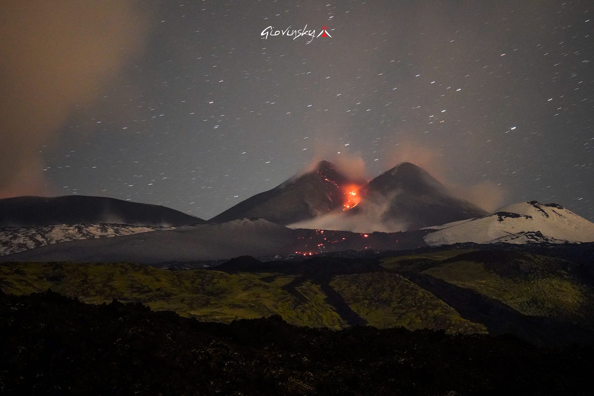
May 24, 2023. EN. Italy / Sicily : Etna , Italy : Stromboli , Mexico : Popocatepetl , Chile : Laguna del Maule , Colombia : Nevado del Ruiz .

May 24 , 2023.


Italy / Sicily , Etna :

Communique on the activity of Etna, May 23, 2023, 08:34 (06:34 UTC).

The National Institute of Geophysics and Volcanology, Osservatorio Etneo, communicates that the monitoring networks recorded at 08:32 (06:32 UTC), the end of volcanic activity.
From the analysis of the images of the video surveillance network, it is observed that the lava flows coming from the Southeast crater are cooling.

Further updates will be communicated soon.

WEEKLY BULLETIN, from May 15, 2023 to May 21, 2023 (issue date May 23, 2023)

ACTIVITY STATUS SUMMARY

In the light of the monitoring data, it is highlighted:

1) VOLCANOLOGICAL OBSERVATIONS: Degassing activity of the summit craters, in particular continuous degassing at the Bocca Nuova crater (BN) and at the Southeast crater (SEC). Between the 18th and the 19th, the eruptive activity resumed, with Strombolian activity at Bocca Nuova and the Southeast crater and ended with a paroxysm at the Southeast crater on the 21st with the establishment of flows of lava.
2) SEISMOLOGY: moderate seismic activity due to fracturing; Swarm in the summit zone on the 18th: The amplitude of the volcanic tremor reached high levels on the 18th in correspondence with the Strombolian activity and very high on the 21st in correspondence with the paroxysm at the Southeast Crater.
3) INFRASOUND: Increase in infrasound activity in correspondence with the paroxysm of May 21.
4) GROUND DEFORMATIONS: During the past week, the ground deformation monitoring networks have recorded variations during the volcanic activity of May 18 and 21 at the inclinometer stations of the summit zone and at the deformation measurement stations . The variations of May 18 are compatible with a rise of magma which would also generate a small intrusion, the variations of May 21 are those characteristic of a lava fountain event.

5) GEOCHEMISTRY: SO2 flux at a high level
CO2 fluxes are at medium-high outgassing values
The isotopic ratio of Helium is at medium-high levels.
The partial pressure of dissolved CO2 does not show significant variations
6) SATELLITE OBSERVATIONS: The thermal activity observed by satellite was moderate in correspondence with the eruptive activity in the summit zone. However, the bad weather conditions strongly affected the analysis of the satellite images.
7) OTHER OBSERVATIONS: The composition of the volcanic glass that was emitted during the May 21, 2023 lava fountain suggests that likely the magma that produced the fountain was the result of a small portion of primitive magma that mixed with the magma that was parked in the « reservoir » (magma chamber).

VOLCANOLOGICAL OBSERVATIONS

The monitoring of Etna’s volcanic activity was carried out through the analysis of images acquired by the network of INGV surveillance cameras, Osservatorio Etneo (INGV-OE) and through
field inspections by INGV-OE staff. For most of the week, although weather conditions prevented systematic observation of activity at the summit craters, short intervals of visibility allowed observation of eruptive activity at Bocca. Nuova and Southeast Craters.
In particular, on the 18th, through images from the Bronte thermal camera, explosive activity was observed at the Bocca Nuova crater from 15:00 UTC. Although there is uncertainty due to weather conditions, it is likely that this activity continued in the following hours, as detected by satellite images.

Satellite image of the lava field by Landsat 8 at 8:45 p.m. GMT on May 22, 2023 (spatial resolution of 30m to 100m)

On the same day at around 2:56 UTC, weak intra-crater Strombolian activity was recorded using the INGV cameras located on Montagnola. Also in this case, it is likely that this modest explosive activity between 7:00 p.m. and 8:00 p.m. was intermittent and not continuous, but on May 21, the modest and episodic explosive activity of the Southeast crater, which already from May 8 to May 14 had showed weak explosions, suddenly evolves into a lava fountain. The event begins at approximately 05:30 UTC and ends at 09:40 UTC. As typical of lava fountain phenomena, the phenomenon creates a plume that extends up to about 10 km (satellite data) and with ash fallout on the Southwest slope (eg, Adrano) and thereafter due to the slow change in direction of the winds, from the South sector (eg Catania) to the South-East sector (eg Aci Castello).

Communique on the activity of Etna, May 24, 2023, 02:05 (00:05 UTC).

The National Institute of Geophysics and Volcanology, Osservatorio Etneo, communicates that the monitoring networks recorded at 01:53 (23:53 UTC), a weak Strombolian activity at the level of the Southeast crater. Lightning is also visible at the Voragine crater.
The simulation of the possible dispersion of the volcanic cloud indicates a North-East direction.
During the last two hours, the average amplitude of volcanic tremors tends to increase and currently reaches almost the high level. The source of the volcanic tremor affects the area of the Southeast crater, at an altitude of about 2800 m above sea level. The infrasonic activity is rather modest. Infrasonic events are mainly located at the Bocca Nuova and Voragine craters, a few events also affect the Southeast crater.
The signals from the inclinometer and GNSS networks do not show any significant variations.

Further updates will be communicated soon.

Source : INGV.

Photo : Giovinsky Sicilia , Landsat 8 / INGV.


Italy , Stromboli :

WEEKLY BULLETIN, from May 15, 2023 to May 21, 2023 (issue date May 23, 2023)

ACTIVITY STATUS SUMMARY

In the light of the monitoring data, it is highlighted:
1) VOLCANOLOGICAL OBSERVATIONS: Normal Strombolian activity was observed during this period. The total hourly frequency fluctuated between average values (6-12 events/h) with a downward trend. The intensity of the explosions was mainly weak in the North crater zone and medium in the Center-South crater zone.
2) SEISMOLOGY: The seismological parameters monitored do not show any significant variations.
3) SOIL DEFORMATIONS: The island’s soil deformation monitoring networks did not show any significant variations to report for the period considered.
4) GEOCHEMISTRY: the flow of SO2 is at an average level
There are no CO2 flux data updates.
There are no C/S data updates.
There are no updates on the R/Ra ratio.
5) SATELLITE OBSERVATIONS: The thermal activity observed from the satellite was generally weak.

VOLCANOLOGICAL OBSERVATIONS
During the observation period, the eruptive activity of Stromboli was characterized thanks to the analysis of the images recorded by the surveillance cameras of the INGV-OE at an altitude of 190m (SCT-SCV) and of the Pizzo sopra la Fossa (SPT). The explosive activity was mainly produced by 2 (two) eruptive vents located in the North zone of the crater and by 3 (three) vents located in the Center-South zone.
Due to the unfavorable weather conditions from May 15 to 16, 17, the visibility of the crater area was insufficient for a correct description of the eruptive activity.

Observations of explosive activity captured by surveillance cameras
In the area of the North crater (N), characterized by a vent located in the N1 sector and one in the N2 sector, a low intensity explosive activity was observed (the erupted products reached a height of less than 80 m) in both sectors. The products ejected are mainly coarse materials (bombs and lapilli) in sector N2 and fine materials (ash) in sector N1. The average frequency of explosions in the North zone fluctuates between 1 and 7 events/h.
In the Center-South zone (CS), the S2 sector, characterized by two active vents, mainly showed explosive activity of medium intensity with emission of coarse materials mixed with fine materials. Sectors S1 and C did not show significant eruptive activity. The average frequency of explosions in the Center-South zone is almost constant with 5 events/h.

Source : INGV.

Photo : Stromboli stati d’animo


Mexico , Popocatepetl :

May 23, 11:00 a.m. (May 23, 5:00 p.m. GMT)

During the last 24 hours, according to the monitoring systems of the Popocatépetl volcano, 22 exhalations accompanied by water vapor, volcanic gases and ash have been detected. In addition, 1,234 minutes of low to large amplitude high frequency tremors were recorded, associated with the continuous emission of gas, water vapor and ash, as well as occasions for the expulsion of incandescent material. a short distance from the volcano.

CENACOM (National Center for Communication and Civil Protection Operations) reported during this period ash falls in the municipalities of Nealtican, Tianguismanalco, Atlixco, San Diego la Mesa, Huaquechula and Atzizihuacán, state of Puebla.

At the time of this report, there is no visibility towards the volcano due to weather conditions in the area. However, a constant emission of water vapor, volcanic gases and slight amounts of ash was observed in a northeasterly direction.

May 23, 7:00 p.m. (May 24, 01:00 GMT)

Update.
The recording of tremors continues with a moderate to low amplitude. The prevailing weather conditions in the region do not allow visibility towards the volcano, however an emission of steam and gas with low ash content has sometimes been observed. Any changes in activity will be reported in a timely manner.

CENAPRED insistently reiterates the recommendation NOT TO CLIMB to the crater of the volcano, because there is the possibility of explosions, as has been seen on several occasions in the past, involving the emission of incandescent fragments. Therefore, he is required to respect the exclusion radius of 12 km. Also, in heavy rain, stay away from the bottom of ravines due to the danger of mudslides and debris.

In accordance with what was declared by the National Civil Protection Coordination during the press conference held on May 21 at CENAPRED, the Popocatépetl volcanic alert traffic light is in YELLOW PHASE 3.

Source : Cenapred.


Chile , Laguna del Maule :

Seismology

The seismological activity of the period was characterized by the recording of:
3690 VT type seismic events, associated with rock fracturing (Volcano-Tectonics). The most energetic earthquake presented a value of local magnitude (ML) equal to 1.8, located 10.5 km west-southwest of the center of the lagoon, at a depth of 9.7 km compared to the average height of the lagoon.
2 LP-type seismic events, associated with fluid dynamics within the volcanic system (Long Period type). The size of the largest earthquake assessed from the Reduced Displacement (DR) parameter was equal to 4 cm2.

Fluid Geochemistry
No anomalies in sulfur dioxide (SO2) emissions into the atmosphere have been reported in the area near the volcanic complex, according to data published by the Tropospheric Monitoring Instrument (TROPOMI) and the Ozone Monitoring Instrument (OMI) Sulfur Dioxide Group.

Geodesy
The geodetic activity of the period was characterized by:
Slight decrease in the elongation rates of 2 monitoring lines, this is linked to a greater displacement of the MAU2 and NIEB stations towards the North, but they continue in an inflationary process and their rates are within the usual parameters of deformation of the volcanic complex .
Changes in the deformation rates of the NIEB station, becoming the station with the greatest deformation, both vertically and horizontally, a change coinciding with the greatest seismicity of the last periods which are located closest to this station.
Rates and trends, of other monitoring stations, similar to previous periods and which show a permanent deformation (inflation) since the year 2012 (since the installation of the geodetic network) and which has been maintained until now.

Stability at inclinometer stations.
Evidence of historical distortion observed in interferograms that coincides in location and magnitude with that observed by the GNSS network.
Possible migration of the deformation source from the MAU2 station to the NIEB station (preliminary results).

Satellite geomorphological analysis
Based on the analysis of Sentinel 2-L2A and Planet Scope satellite images, no morphological changes were identified during the assessed period, in the area of the volcanic complex.
The VT seismic activity record persists, mainly located towards the Southwest sector, although with less recurrence than the previous periods. The deformation process remains crustal with high flows, maintaining a slight modification in its behavior, linked to an increase in vertical movements at the Nieblas station. In turn, no superficial changes are observed.
That said, it is considered that activity levels are still above their baseline threshold, maintaining the technical alert in yellow and a possible 2 km radius of assignment measured from the source of the anomaly. of CO2 detected.

YELLOW TECHNICAL ALERT: Changes in volcanic activity behavior

Source : Sernageomin.

Photo : Cegemar.


Colombia , Nevado del Ruiz : 

Manizales, May 23, 2023 10:40 a.m.

Regarding the monitoring of the activity of the NEVADO DEL RUIZ VOLCANO, the MINISTRY OF MINES AND ENERGY through the COLOMBIAN GEOLOGICAL SERVICE (SGC) informs that:

From 09:00 yesterday (May 22) until the time of publication of this bulletin, the seismic activity related to the movement of fluids inside the volcanic conduits presented an increase in the number of earthquakes and continued to show seismic energy levels released similar to those of the day before (May 21). Some of the seismic signals were associated with pulsating ash emissions confirmed by web cameras used for volcanic monitoring.

On the other hand, the seismicity associated with the fracturing of the rock inside the volcanic edifice increased in number of earthquakes and showed levels of seismic energy released similar to those of the previous day (21 May ). This seismicity was located in the northeast, north and south sectors of the volcano and in the Arenas crater, at a maximum distance of 6 km from it and at depths between 1 and 7 km.
Regarding the surface activity, the maximum height of the column of gas and / or ash was 1300 m measured from the summit of the volcano and it presented a preferential direction of dispersion towards the North-East. Variations in the outgassing of sulfur dioxide and the release of water vapor from the crater into the atmosphere continue.

The level of activity of the volcano remains at the ORANGE LEVEL of activity or (II): PROBABLE ERUPTION IN TERM OF DAYS OR WEEKS.

Source et photo : SGC

24 Mai 2023. FR. Italie / Sicile : Etna , Italie : Stromboli , Mexique : Popocatepetl , Chili : Laguna del Maule , Colombie : Nevado del Ruiz . 

24 Mai 2023.


Italie / Sicile , Etna :

Communiqué sur l’activité de l’Etna , 23 Mai 2023 , 08:34 (06:34 UTC) .

L’Institut national de géophysique et de volcanologie, Osservatorio Etneo, communique que les réseaux de surveillance ont enregistré à 08h32 (06h32 UTC), la fin de l’activité volcanique.
À partir de l’analyse des images du réseau de vidéosurveillance, on observe que les coulées de lave provenant du cratère Sud-Est se refroidissent.

D’autres mises à jour seront communiquées rapidement.

BULLETIN HEBDOMADAIRE, du 15 Mai 2023 au 21 Mai 2023 .(date d’émission 23 Mai 2023)

RÉSUMÉ DE L’ÉTAT DE L’ACTIVITÉ

A la lumière des données de suivi, il est mis en évidence :

1) OBSERVATIONS VOLCANOLOGIQUES : Activité de dégazage des cratères sommitaux, en particulier dégazage continu au cratère de la Bocca Nuova (BN) et au cratère Sud-Est (SEC). Entre le 18 et le 19, l’activité éruptive a repris, avec une activité strombolienne à la Bocca Nuova et au cratère Sud-Est et s’est terminée par un paroxysme au cratère Sud-Est le 21 avec la mise en place de coulées de lave.
2) SISMOLOGIE : activité sismique modérée due à la fracturation ; Essaim dans la zone sommitale le 18 : L’amplitude du tremor volcanique a atteint des niveaux élevés le 18 en correspondance avec l’activité strombolienne et très élevée le 21 en correspondance avec le paroxysme au Cratère Sud-Est.
3) INFRASONS : Augmentation de l’activité infrasonore en correspondance avec le paroxysme du 21 mai.
4) DÉFORMATIONS DU SOL : Au cours de la semaine écoulée, les réseaux de surveillance des déformations du sol ont enregistré des variations lors de l’activité volcanique des 18 et 21 mai aux stations inclinométriques de la zone sommitale et aux stations de mesure de déformation. Les variations du 18 mai sont compatibles avec une remontée de magma qui générerait également une petite intrusion, les variations du 21 mai sont celles caractéristiques d’un événement de fontaine de lave.

5) GEOCHIMIE : Flux de SO2 à un niveau élevé
Les flux de CO2 se situent à des valeurs de dégazage moyennes-élevées
Le rapport isotopique de l’ Hélium se situe à des niveaux moyens-élevés.
La pression partielle du CO2 dissous ne présente pas de variations significatives
6) OBSERVATIONS SATELLITAIRES : L’activité thermique observée par satellite était modérée en correspondance avec l’activité éruptive dans la zone sommitale. Cependant, les mauvaises conditions météorologiques ont fortement affecté l’analyse des images satellites.
7) AUTRES OBSERVATIONS : La composition du verre volcanique qui a été émis lors de la fontaine de lave du 21 mai 2023 suggère que probablement le magma qui a produit la fontaine est le résultat de une petite portion de magma primitif qui s’est mélangée au magma qui était stationné dans le « réservoir » (chambre magmatique).

OBSERVATIONS VOLCANOLOGIQUES

La surveillance de l’activité volcanique de l’Etna a été réalisée à travers l’analyse des images acquises par le réseau de caméras de surveillance de l’INGV, Osservatorio Etneo (INGV-OE) et à travers
inspections sur le terrain par le personnel de l’INGV-OE. Pendant la majeure partie de la semaine, bien que les conditions météorologiques aient empêché une observation systématique de l’activité au niveau des cratères sommitaux, de courts intervalles de temps de visibilité ont permis l’observation de l’activité éruptive au niveau de la Bocca Nuova et des cratères du Sud-Est .
En particulier, le 18, à travers les images de la caméra thermique de Bronte, une activité explosive a été observée au niveau du cratère de la Bocca Nuova à partir de 15h00 UTC. Bien qu’il y ait une incertitude due aux conditions météorologiques, il est probable que cette activité se soit poursuivie dans les heures suivantes, comme le détectent les images satellites.

Image satellite du champ de lave par Landsat 8 à 20h45 GMT le 22 mai 2023 (résolution spatiale de 30m à 100m)

Le même jour vers 2h56 UTC, une faible activité strombolienne intra-cratère a été enregistrée grâce aux caméras INGV situées sur la Montagnola  . Dans ce cas également, il est probable que cette activité explosive modeste entre 19h00 et 20h00 était intermittente et non continue, mais le 21 mai, l’activité explosive modeste et épisodique du cratère du Sud-Est, qui déjà du 8 au 14 mai avait montré de faibles explosions, évolue soudainement vers une fontaine de lave. L’événement commence à environ 05h30 UTC et se termine à 9h40 UTC. Comme typique des phénomènes de fontaine de lave, le phénomène crée un panache qui s’étend jusqu’à environ 10 km (données satellitaires) et avec des retombées de cendres sur le versant Sud-Ouest (par exemple, Adrano) et par la suite en raison du lent changement de direction des vents, du secteur Sud (par exemple, Catane) au secteur Sud-Est (par exemple, Aci Castello).

Communiqué sur l’activité de l’Etna , 24 Mai 2023 , 02:05 (00:05 UTC) .

L’Institut National de Géophysique et de Volcanologie, Osservatorio Etneo, communique que les réseaux de surveillance ont enregistré à 01h53 (23h53 UTC), une faible activité strombolienne au niveau du cratère Sud-Est. Des éclairs sont également visibles au niveau du cratère de la Voragine.
La simulation de la possible dispersion du nuage volcanique indique une direction Nord-Est.
Au cours des deux dernières heures, l’amplitude moyenne des tremors volcaniques a tendance à augmenter et atteint actuellement presque le niveau élevé. La source du tremor volcanique affecte la zone du cratère Sud-Est, à une altitude d’environ 2800 m au-dessus du niveau de la mer. L’activité infrasonore est plutôt modeste. Les événements infrasonores sont principalement localisés aux cratères de la Bocca Nuova et de la Voragine, quelques événements affectent également le cratère Sud-Est.
Les signaux des réseaux inclinométriques et GNSS ne présentent pas de variations significatives.

D’autres mises à jour seront communiquées rapidement.

Source : INGV.

Photo : Giovinsky Sicilia , Landsat 8 / INGV.


Italie , Stromboli :

BULLETIN HEBDOMADAIRE, du 15 Mai 2023 au 21 Mai 2023 .(date d’émission 23 Mai 2023)

RÉSUMÉ DE L’ÉTAT DE L’ACTIVITÉ

A la lumière des données de suivi, il est mis en évidence :
1) OBSERVATIONS VOLCANOLOGIQUES : Une activité strombolienne normale a été observée durant cette période. La fréquence horaire totale a fluctué entre des valeurs moyennes (6-12 événements/h) avec une tendance à la baisse. L’intensité des explosions était principalement faible dans la zone de cratère Nord et moyenne dans la zone de cratère Centre-Sud.
2) SISMOLOGIE : Les paramètres sismologiques suivis ne présentent pas de variations significatives.
3) DEFORMATIONS DES SOLS : Les réseaux de surveillance des déformations des sols de l’île n’ont pas montré de variations significatives à signaler pour la période considérée
4) GEOCHIMIE : le flux de SO2 est à un niveau moyen
Il n’y a pas de mises à jour des données de flux de CO2.
Il n’y a pas de mises à jour des données C/S.
Il n’y a pas de mises à jour sur le rapport R/Ra.
5) OBSERVATIONS SATELLITAIRES : L’activité thermique observée depuis le satellite était généralement faible.

OBSERVATIONS VOLCANOLOGIQUES
Au cours de la période d’observation, l’activité éruptive du Stromboli a été caractérisée grâce à l’analyse des images enregistrées par les caméras de surveillance de l’INGV-OE à une altitude de 190m (SCT-SCV) et du Pizzo sopra la Fossa (SPT). L’activité explosive a été principalement produite par 2 (deux) évents éruptifs situés dans la zone Nord du cratère et par 3 (trois) évents situés dans la zone Centre-Sud.
En raison des conditions météorologiques défavorables du 15 au 16 mai 17, la visibilité de la zone du cratère était insuffisante pour une description correcte de l’activité éruptive.

Observations d’activité explosive captées par des caméras de surveillance
Dans la zone du cratère Nord (N), caractérisée par un évent situé dans le secteur N1 et un dans le secteur N2, une activité explosive de faible intensité a été observée (les produits en éruption ont atteint une hauteur inférieure à 80 m) dans les deux secteurs. Les produits éjectés sont principalement des matériaux grossiers (bombes et lapilli) dans le secteur N2 et des matériaux fins (cendres) dans le secteur N1. La fréquence moyenne des explosions en zone Nord oscille entre 1 et 7 événements/h.
Dans la zone Centre-Sud (CS), le secteur S2, caractérisé par deux évents actifs, a principalement montré une activité explosive d’intensité moyenne avec émission de matériaux grossiers mélangés à des matériaux fins. Les secteurs S1 et C n’ont pas montré d’activité éruptive significative. La fréquence moyenne des explosions dans la zone Centre-Sud est quasi constante avec 5 événements/h.

Source : INGV.

Photo : Stromboli stati d’animo


Mexique , Popocatepetl :

23 mai, 11h00 (23 mai, 17h00 GMT)

Au cours des dernières 24 heures, selon les systèmes de surveillance du volcan Popocatépetl, 22 exhalaisons accompagnées de vapeur d’eau, de gaz volcaniques et de cendres ont été détectées. De plus, 1 234 minutes de tremors à haute fréquence de faible à grande amplitude ont été enregistrées, associées à l’émission continue de gaz, de vapeur d’eau et de cendres, ainsi qu’à des occasions d’expulsion de matériaux incandescents à une courte distance du volcan .

Le CENACOM (Centre national des opérations de communication et de protection civile) a signalé au cours de cette période des chutes de cendres dans les municipalités de Nealtican, Tianguismanalco, Atlixco, San Diego la Mesa, Huaquechula et Atzizihuacán, État de Puebla.

Au moment de ce rapport, il n’y a pas de visibilité vers le volcan en raison des conditions météorologiques dans la région. Cependant, une émission constante de vapeur d’eau, de gaz volcaniques et de légères quantités de cendres a été observée en direction du Nord-Est .

23 mai, 19h00 (24 mai, 01h00 GMT)

Actualisation.
L’enregistrement des tremors se poursuit avec une amplitude modérée à faible. Les conditions météorologiques qui prévalent dans la région ne permettent pas la visibilité vers le volcan, cependant une émission de vapeur et de gaz à faible teneur en cendres a parfois été observée. Tout changement d’activité sera signalé en temps opportun.

Le CENAPRED réitère avec insistance la recommandation de NE PAS MONTER jusqu’au cratère du volcan, car il y a possibilité d’explosions, comme on l’a vu à plusieurs reprises dans le passé, impliquant l’émission de fragments incandescents  . Par conséquent, il est tenu de respecter le rayon d’exclusion de 12 km. De même, en cas de fortes pluies, éloignez-vous du fond des ravins en raison du danger de coulées de boue et de débris.

Conformément à ce qui a été déclaré par la Coordination nationale de la protection civile lors de la conférence de presse tenue le 21 mai au CENAPRED, le feu de signalisation d’alerte volcanique du Popocatépetl est en JAUNE PHASE 3.

Source : Cenapred.


Chili , Laguna del Maule :

Sismologie

L’activité sismologique de la période a été caractérisée par l’enregistrement de :
3690 événements sismiques de type VT, associés à la fracturation des roches (Volcano-Tectonique). Le tremblement de terre le plus énergétique a présenté une valeur de magnitude locale (ML) égale à 1,8, situé à 10,5 km à l’Ouest-Sud-Ouest du centre de la lagune, à une profondeur de 9,7 km par rapport à la hauteur moyenne de la lagune.
2 événements sismiques de type LP, associés à la dynamique des fluides au sein du système volcanique (type Longue Période). La taille du plus grand tremblement de terre évaluée à partir du paramètre Déplacement réduit (DR) était égale à 4 cm2.

Géochimie des fluides
Aucune anomalie dans les émissions de dioxyde de soufre (SO2) dans l’atmosphère n’a été signalée dans le secteur proche du complexe volcanique, selon les données publiées par le Tropospheric Monitoring Instrument (TROPOMI) et le Ozone Monitoring Instrument (OMI) Sulfur Dioxide Group.

Géodésie
L’activité géodésique de la période a été caractérisée par :
Légère diminution des taux d’allongement de 2 lignes de surveillance, ceci est lié à un déplacement plus important des stations MAU2 et NIEB vers le Nord, mais elles continuent dans un processus inflationniste et leurs taux sont dans les paramètres habituels de déformation du complexe volcanique.
Changements dans les taux de déformation de la station NIEB, devenant la station avec la plus grande déformation, à la fois verticalement et horizontalement, un changement coïncidant avec la plus grande sismicité des dernières périodes qui sont situées les plus proches de cette station.
Taux et tendances, des autres stations de surveillance, similaires aux périodes précédentes et qui montrent une déformation permanente (inflation) depuis l’année 2012 (depuis l’installation du réseau géodésique) et qui s’est maintenu jusqu’à présent.

Stabilité dans les stations inclinométriques.
Preuve de la déformation historique observée dans les interférogrammes et qui coïncide en emplacement et en ampleur avec celle observée par le réseau GNSS.
Migration possible de la source de déformation de la station MAU2 vers la station NIEB (résultats préliminaires).

Analyse géomorphologique satellitaire
D’après l’analyse des images satellite Sentinel 2-L2A et Planet Scope, aucun changement morphologique n’a été identifié au cours de la période évaluée, dans la zone du complexe volcanique.
L’ enregistrement d’activité sismique VT persiste, principalement localisé vers le secteur Sud-Ouest, bien qu’avec moins de récurrence que les périodes précédentes. Le processus de déformation reste crustal avec des débits élevés, conservant une légère modification de son comportement, liée à une augmentation des mouvements verticaux de la station Nieblas. À leur tour, aucun changement superficiel n’est observé.
Cela dit, il est considéré que les niveaux d’activité sont toujours au-dessus de leur seuil de base, maintenant l’ alerte technique en jaune et un rayon d’affectation possible de 2 km mesuré à partir de la source de l’anomalie de CO2 détectée.

ALERTE TECHNIQUE JAUNE : Modifications du comportement de l’activité volcanique

Source : Sernageomin.

Photo : Cegemar.


Colombie , Nevado del Ruiz : 

Manizales, 23 mai 2023 10h40

Concernant le suivi de l’activité du VOLCAN NEVADO DEL RUIZ, le MINISTÈRE DES MINES ET DE L’ÉNERGIE à travers le SERVICE GÉOLOGIQUE COLOMBIEN (SGC) informe que :

De 09h00 hier (22 mai) jusqu’au moment de la publication de ce bulletin, l’activité sismique liée au mouvement des fluides à l’intérieur des conduits volcaniques a présenté une augmentation du nombre de tremblements de terre et a continué à montrer des niveaux d’énergie sismique libérés similaires à celles de la veille (21 mai). Certains des signaux sismiques étaient associés à des émissions de cendres pulsatiles confirmées par les caméras Web utilisées pour la surveillance volcanique.

D’autre part, la sismicité associée à la fracturation de la roche à l’intérieur de l’édifice volcanique a augmenté en nombre de tremblements de terre et a montré des niveaux d’énergie sismique libérés similaires à ceux de la veille (21 mai). Cette sismicité était localisée dans les secteurs Nord-Est, Nord et Sud du volcan et dans le cratère Arenas, à une distance maximale de 6 km de celui-ci et à des profondeurs comprises entre 1 et 7 km.
Concernant l’activité de surface, la hauteur maximale de la colonne de gaz et/ou de cendres était de 1300 m mesurée depuis le sommet du volcan et elle a présenté une direction préférentielle de dispersion vers le Nord-Est. Les variations dans le dégazage du dioxyde de soufre et la libération de vapeur d’eau du cratère dans l’atmosphère se poursuivent.

Le niveau d’activité du volcan reste au NIVEAU ORANGE d’activité ou (II): ERUPTION PROBABLE EN TERME DE JOURS OU DE SEMAINES.

Source et photo : SGC