March 10 , 2022.
Indonesia , Merapi :
VOLCANO OBSERVATORY NOTICE FOR AVIATION – VONA
Issued : February 09 , 2022
Volcano : Merapi (263250)
Current Aviation Colour Code : RED
Previous Aviation Colour Code : unassigned
Source : Merapi Volcano Observatory
Notice Number : 2022MER01
Volcano Location : S 07 deg 32 min 31 sec E 110 deg 26 min 31 sec
Area : Special Region of Yogyakarta, Indonesia
Summit Elevation : 9498 FT (2968 M)
Volcanic Activity Summary :
Eruption with volcanic ash cloud at 16h18 UTC (23h18 local). Eruption and ash emission is continuing
Volcanic Cloud Height :
Best estimate of ash-cloud top is around 19098 FT (5968 M) above sea level, may be higher than what can be observed clearly. Source of height data: ground observer.
Other Volcanic Cloud Information :
Ash cloud moving to the southeast.
Remarks :
PDC moving to the southeast, wind direction to the west.
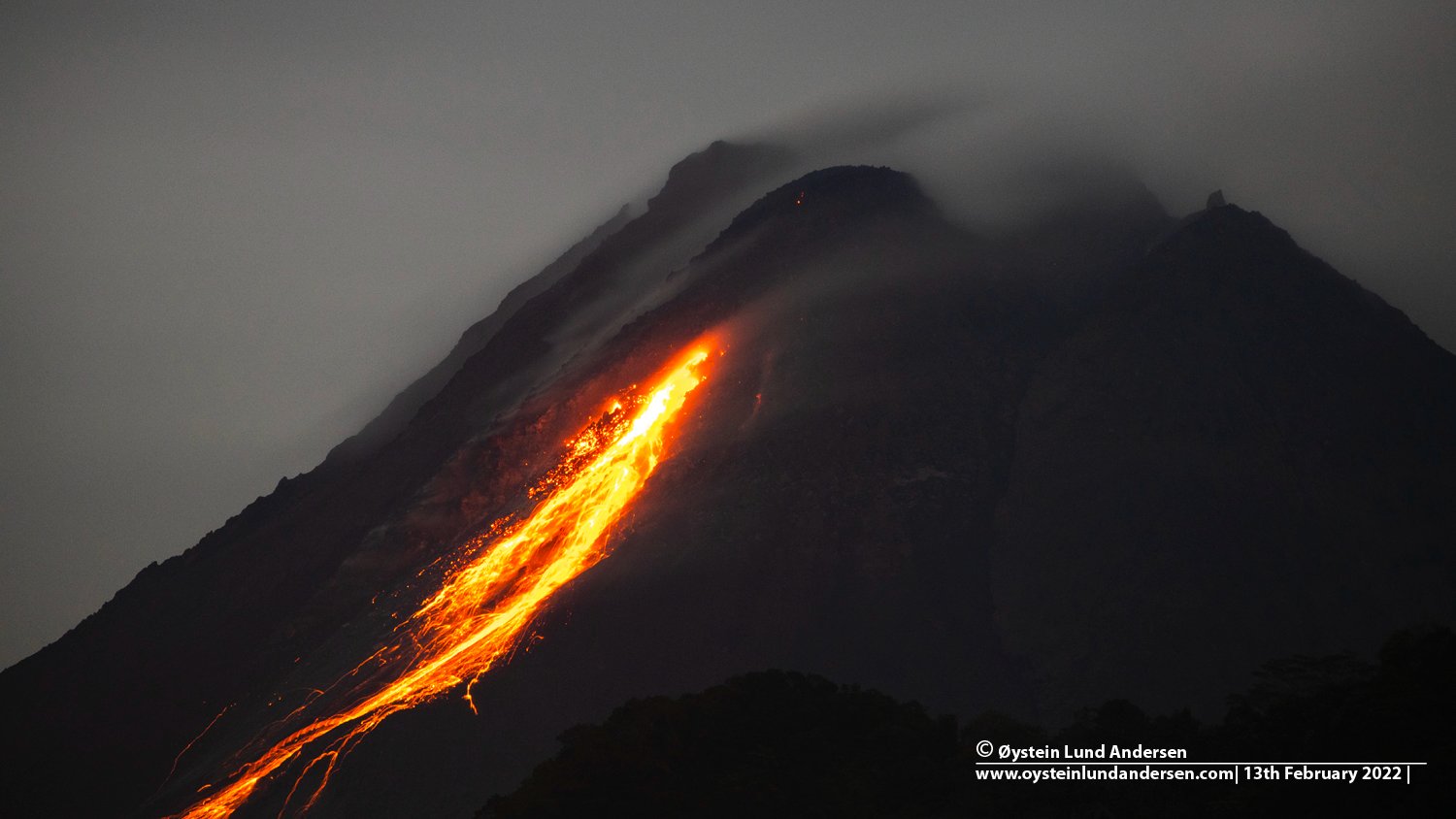
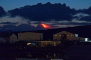
The Merapi avalanche hot cloud of March 10, 2022 at 7:33 a.m. WIB was recorded on a seismogram with an amplitude of 55 mm and a duration of 172 seconds. The slip distance is ±2,000 m to the southeast (Kali Gendol).
The Merapi erupted overnight, sending hot lava and ash down its slopes and prompting more than 250 nearby residents to evacuate, the country’s disaster mitigation agency (BNPB) said on Thursday.
The BNPB said 253 residents around the volcano in Indonesia’s Yogyakarta province were evacuated, while ash blanketed some villages. No casualties were immediately reported.
The agency said the last hot cloud was sent over the southeast slope of the volcano at 7:33 a.m. local time on Thursday.
Sources : Magma Indonésie , PVMBG , nst.com.my.
Photo : Oystein Lund Andersen.
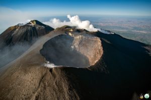
Japan , Shinmoedake :
JMA reported an increase in volcanic earthquakes just below Shinmoedake (Shinmoe peak, a stratovolcano of the Kirishimayama volcano group). A total of 17 events were recorded during 1-2 March, prompting JMA to raise the Alert Level to 2 (on a scale of 1-5) on 2 March. No changes were seen at the volcano during a field visit that same day. Volcanic earthquakes persisted, with 5-12 events per day recorded through 7 March. Emissions had risen no higher than 30 m above the crater rim since 1 January, and fumarolic plumes continued to rise no higher than 100 m from a fissure on the W flank. During a field survey conducted on 4 March at the base of the volcano, sulfur dioxide emissions were below the detectable limit and no changes to area hot springs were observed.
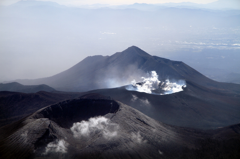
Kirishimayama is a large group of more than 20 Quaternary volcanoes located north of Kagoshima Bay. The late-Pleistocene to Holocene dominantly andesitic group consists of stratovolcanoes, pyroclastic cones, maars, and underlying shield volcanoes located over an area of 20 x 30 km. The larger stratovolcanoes are scattered throughout the field, with the centrally located Karakunidake being the highest. Onamiike and Miike, the two largest maars, are located SW of Karakunidake and at its far eastern end, respectively. Holocene eruptions have been concentrated along an E-W line of vents from Miike to Ohachi, and at Shinmoedake to the NE. Frequent small-to-moderate explosive eruptions have been recorded since the 8th century.
Sources : GVP , Japan Meteorological Agency (JMA).
Photo : S. Nakano 08.03.2011 / Geological survey of Japan
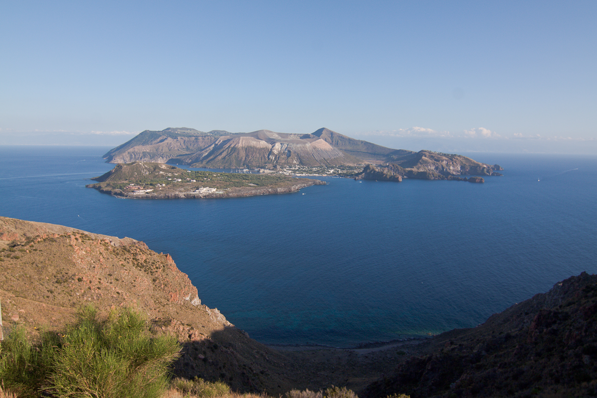
Italy , Vulcano :
WEEKLY BULLETIN, from February 28, 2022 to March 06, 2022. (issue date March 08, 2022)
ACTIVITY STATUS SUMMARY.
In the light of the surveillance data, it is highlighted:
1) Temperature of the crater fumaroles: The updated data of the temperatures recorded on the edge of the crater show stable values and confirm the continuation of the thermal anomaly. On the internal side, the values are always stable at 114°C.
2) CO2 flux in the crater area: The CO2 flux in the crater area remains at high values.
3) SO2 flux in the crater area: SO2 flux at a medium-high level and decreasing
4) Geochemistry of fumarolic gases: No update is available concerning the geochemistry of fumarolic gases.
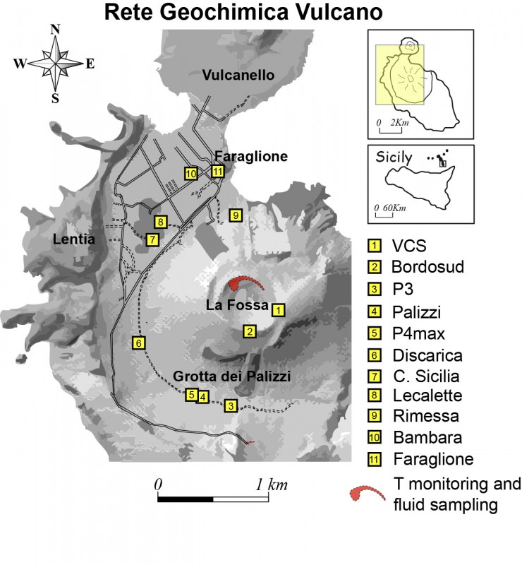
5) CO2 fluxes at the base of the La Fossa cone and in the Vulcano Porto area: The CO2 fluxes recorded in the Rimessa, C. Sicilia and P4max sites remain at medium-high values; in the Faraglione site, there are values close to the background level.
6) Geochemistry of thermal aquifers: The physico-chemical parameters recorded in the wells of Camping Sicilia and Bambara remain stable at high values, although showing a very slight downward trend.
7) Local seismicity: Low rate of occurrence of local micro-shocks. Modest increase in the rate of occurrence of VLP-like events.
8) Regional seismicity: Low level fracturing seismicity: 1 single earthquake with Ml = 1.1
9) Deformations – GNSS: The network of permanent GNSS stations has not recorded any significant changes.
10) Deformations – Inclinometry: The inclinometric network has not recorded any significant changes
11) Other observations: Gravimetry: During the period considered, no significant variation was recorded.
Mobile GNSS: Mobile GNSS stations do not appear to show significant changes over the reporting period.
GB-RAR: The GB-RAR monitoring results referring to the period December 14, 2021 – March 07, 2022, show a general stability of the area, with deformations along the LOS of less than 1 mm.
TEMPERATURE OF THE FUMAROLES OF THE CRATER:
The reference sensor for the maximum temperature showed a weak upward trend; the weekly average is 385°C, with a maximum recorded heat of 388°C. Not far from T1, the T2 sensor instead showed a decreasing trend and larger disturbances of exogenous origin.
Locally, the sensor placed in the fumarole of the internal slope did not exceed 114.2°C, suggesting the presence of a liquid phase and a flow influenced by exogenous conditions.
CO2 FLOW IN THE CRATER AREA
The soil CO2 flux values in the summit zone on a daily average (VCSCS) show high values around 9413 g/m2/day (value of March 05, 2022), still on an order of magnitude higher than the averages recorded in over the past 10 years.
The average value of the CO2 flux (monthly average) in the month of February 2022 is 10875 g/m2/day. Thus, on a monthly scale, we observe a stabilization of degassing at high values, with a slight decrease compared to the previous month (January: 13425 g/m2/day).
The data is updated on March 05, 2022.
Source : INGV.
Photos : INGV , .
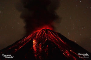
Guatemala , Fuego :
SPECIAL VOLCANOLOGICAL BULLETIN, March 9, 2022, 3:15 p.m. local time
In the follow-up of the BEFGO bulletin # 013-2022 and on the basis of the instrumental parameters and the field monitoring carried out during the last hours, explosions of weak, moderate and strong characteristics are recorded with abundant ash emissions which move towards the West and the Southwest. These continue to generate weak to moderate avalanches towards the ravines of Ceniza, Trinidad and Las Lajas. In the crater, degassing and incandescence continue to be observed overnight and early in the morning.
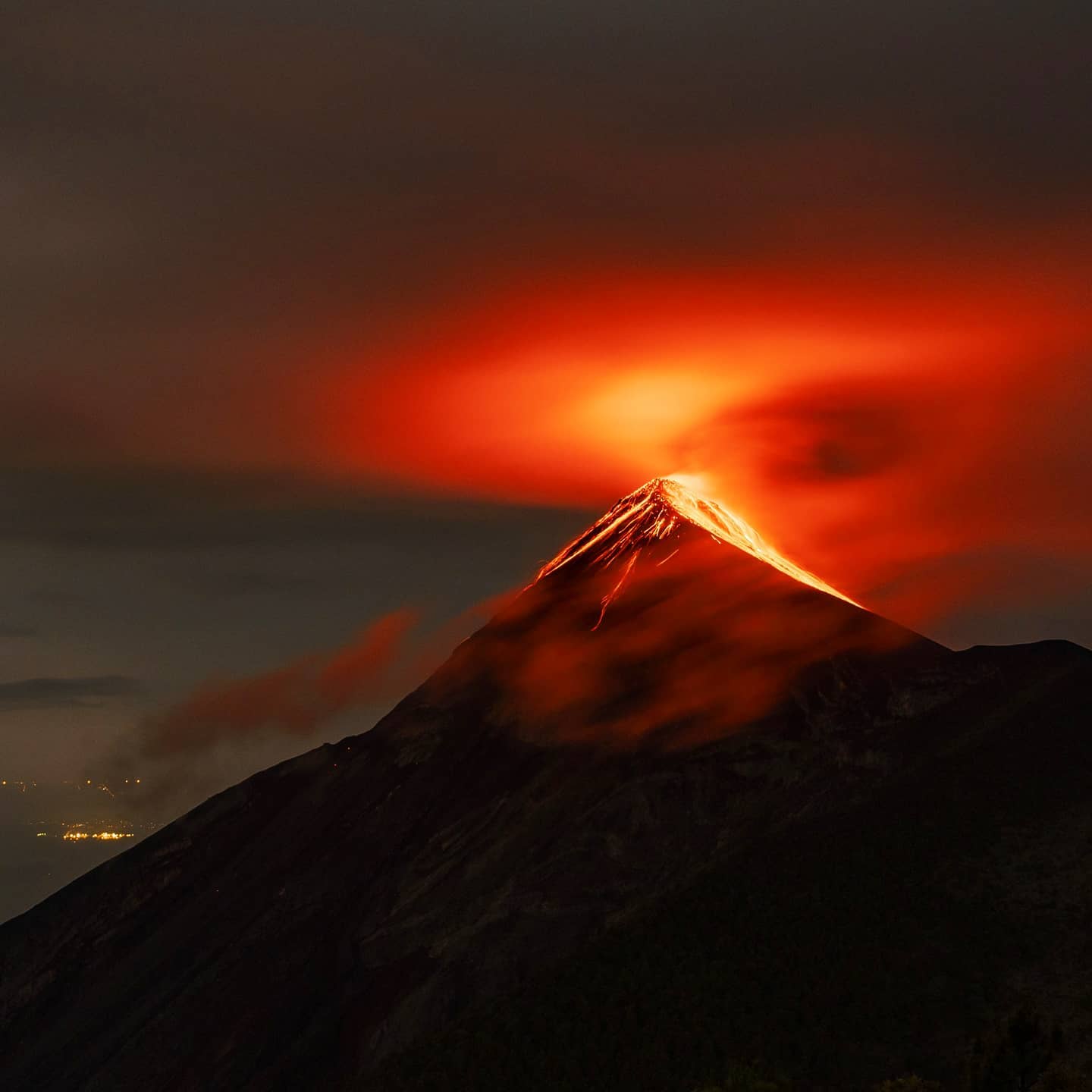
No active lava flow is observed. The analysis of satellite images and field monitoring carried out by the staff of the Fuego Volcano Observatory OVFGO, has confirmed that the area affected by the recent pyroclastic flows includes a radius of 7 km around the crater towards the south. -West, South and Southeast, where vegetation and crops affected by high temperature gas and ash clouds are also confirmed. In addition, a large amount of ash falls on the vegetation, the roofs of the houses and the streets of the communities. These ashes can be carried by the wind and remain suspended at low levels in the air, creating a foggy environment for several hours which can be detrimental to the health of people. In the presence of rain, lahars can be generated in all the ravines of the volcano, but they are expected to be more recurrent and more important in the ravines of El Jute, Las Lajas, Ceniza and Trinidad.
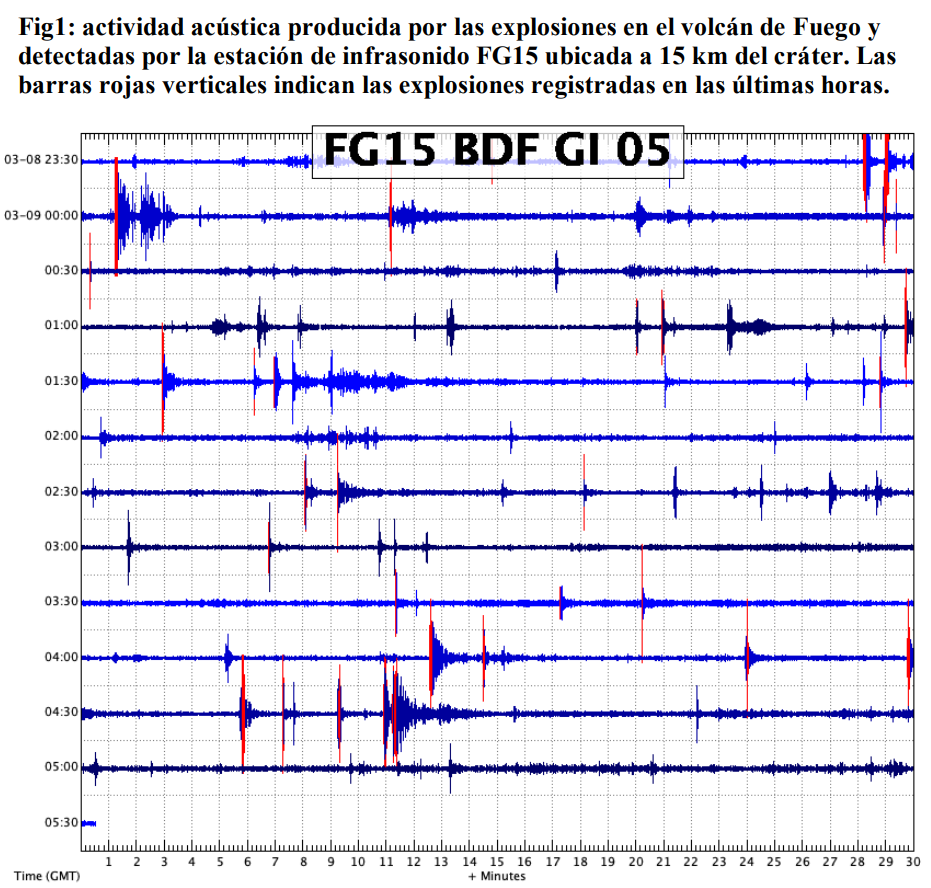
It is not excluded that new lava flows will be generated towards other ravines, as well as violent ash-laden explosions and avalanches of moderate characteristics towards one of the ravines of the Fuego volcano, which is why we should not not stay near or in the ravines of the volcano. INSIVUMEH maintains visual and instrumental monitoring of volcanic activity through seismic stations, volcano spotters and web cameras.
Source : Insivumeh.
Photo : Diego Rizzo .
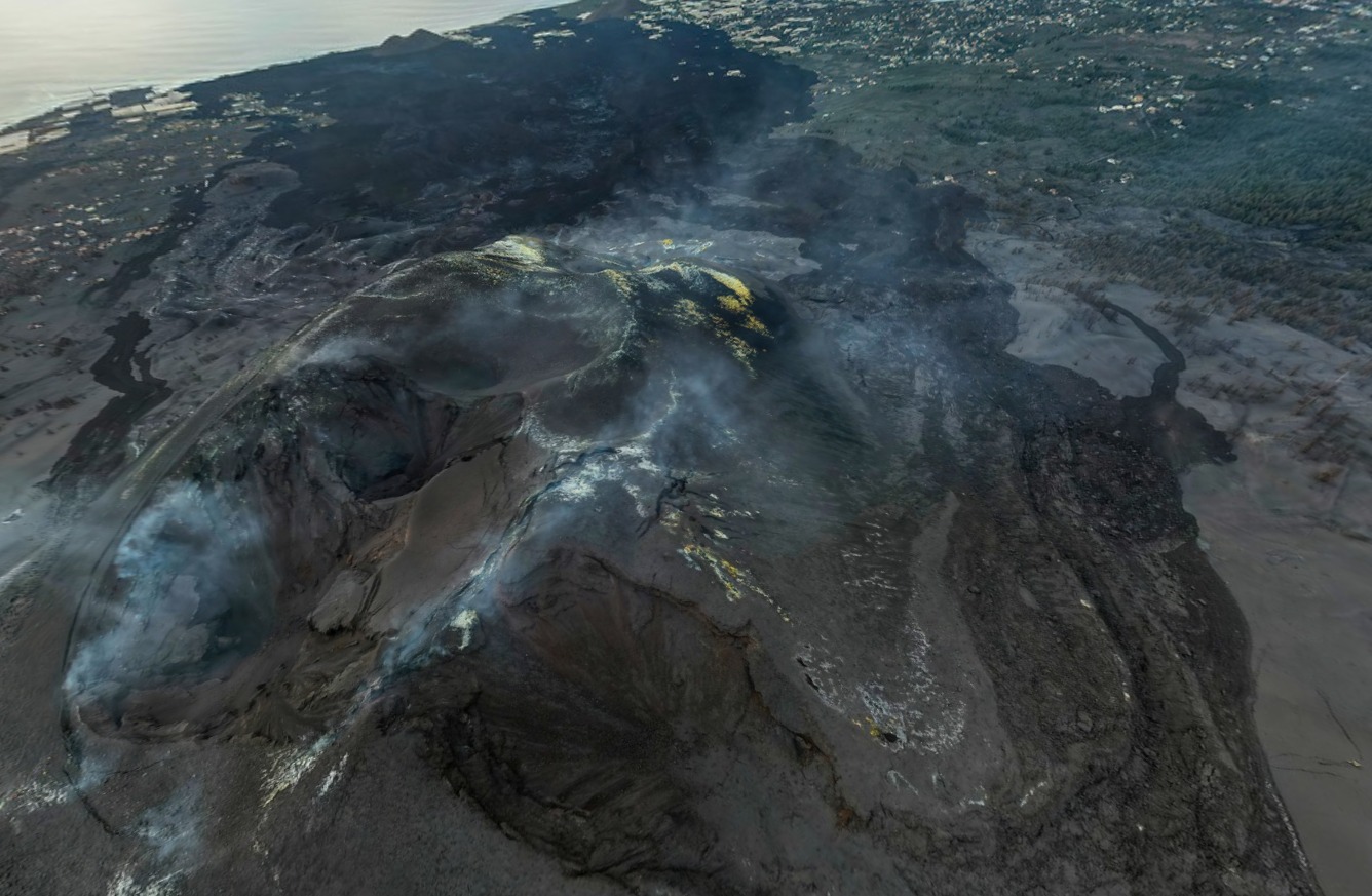
La Palma , Cumbre Vieja :
Post-eruption activity on Cumbre Vieja, La Palma. 09 March 2022, 09:00 UTC
In the last 7 days, since the last communication (March 1 at 9:00 UTC), 64 earthquakes have been located on the island of La Palma. The magnitudes are between 0.7 and 2.5 (mbLg). Three of these earthquakes were weakly felt by the population, with a maximum intensity of II (EMS98). The location of hypocenters continues below the central area of Cumbre Vieja, in the same areas as in previous weeks, at depths between 0 and 18 km. Only two earthquakes of this period, of magnitudes 1.9 and 1.5 mbLg, were located at greater depths (24 and 30 km), respectively.
The network of permanent GNSS stations on the island does not show significant deformations that could be associated with volcanic activity.
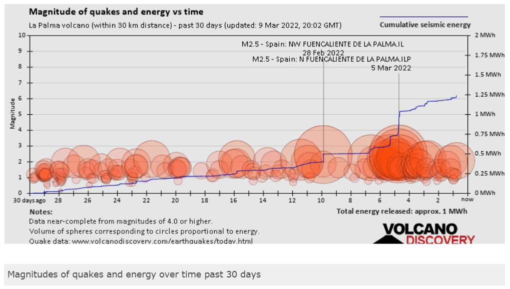
The curve of the accumulated seismic energy released shows a small rise from about 4-5 days ago towards the reservoir at 10-14 km, mainly by the gases which followed their way to the surface through the closed conduit, this could be the reason for an increase in the rate of gas emission from the volcanic cone. In fact, there was a little pressurization in the final area of the conduit between 1 and 6 km, mostly from gases or steam, possibly due to water entering the hot areas of the conduits . This certainly caused the deformation yesterday at stations LP03 and LP04 with a swelling of 3-4 cm and some earthquakes in the conduit, highlighting a 2.1 to 6 km in the conduit area this morning that was felt.
Volcanic activity in the Canary Islands:
Throughout the month of February, a total of 273 earthquakes were located in the Canary Islands region, with a maximum magnitude of 3.7 mbLg in the earthquake located on the 19th at 21:22 (UTC), between the islands of Tenerife and Gran Canaria, at a depth of 13 km and which was felt with intensity II (EMS98) in many populations of the two islands.
On the 8th, at 11:54 a.m. (UTC), an earthquake of magnitude 3.3 (mbLg) was located, with an epicenter on the southwest coast of Fuerteventura, felt with intensity II (EMS98) in the towns of La Pared, Majorera. , Toto and Valley of Santa Inés. Further west, between the islands of Fuerteventura and Gran Canaria, this month 13 earthquakes were located, between magnitudes 1.4 and 3.3 (mbLg) and depths between 0 and 41 km . On the coast of Mogan, west of Gran Canaria, on the 19th, an earthquake of magnitude 2.2 (mbLg) and depth of 2 km was located, which was weakly felt with intensity II (EMS98 ) in the city of Maspalomas.
Between the islands of Gran Canaria and Tenerife, 35 earthquakes were located during this period, with magnitudes between 0.7 and 3.7 mbLg and depths between 0 and 44 km. In the interior of the island of Tenerife, the seismic activity was located mainly in the areas near Adeje, Vilaflor de Chasna and Fasnia, with a total of 46 earthquakes located between magnitudes 0.0 and 2 .2 (mbLg) and depths between 1 and 34 km.
In the volcanic process that is developing on the island of La Palma, which began last September 19 and of which we have been in a post-eruptive phase since December 13 at 22:21 (UTC), 163 earthquakes have been located , with magnitudes between 0.2 and 2.5 (mbLg) and depths between 0 and 37 km. In total, 4 of these earthquakes were felt weakly by the population of the island of La Palma, with a maximum intensity of II-III (EMS98).
In the area of El Hierro Island, 3 earthquakes between magnitudes 1.9 and 3.0 (mbLg) and depths between 19 and 36 km were located.
The analyzes of the data obtained at the control points of the geochemical monitoring network of the island of La Palma indicate that, throughout the month of February, variations were detected both in the emission of radon and thoron and in the concentrations and isotopic ratios of helium and carbon from dissolved gases, directly related to the evolution of the post-eruptive process.
The results obtained from the observations made by the Permanent GNSS Stations of the Volcanic Surveillance Network, the InSAR processing and the signal from the inclinometer do not show any significant deformation on any of the islands.
Sources : IGN es , Volcanes y Ciencia Hoy .
Photo : I love the world.