December 13, 2019.
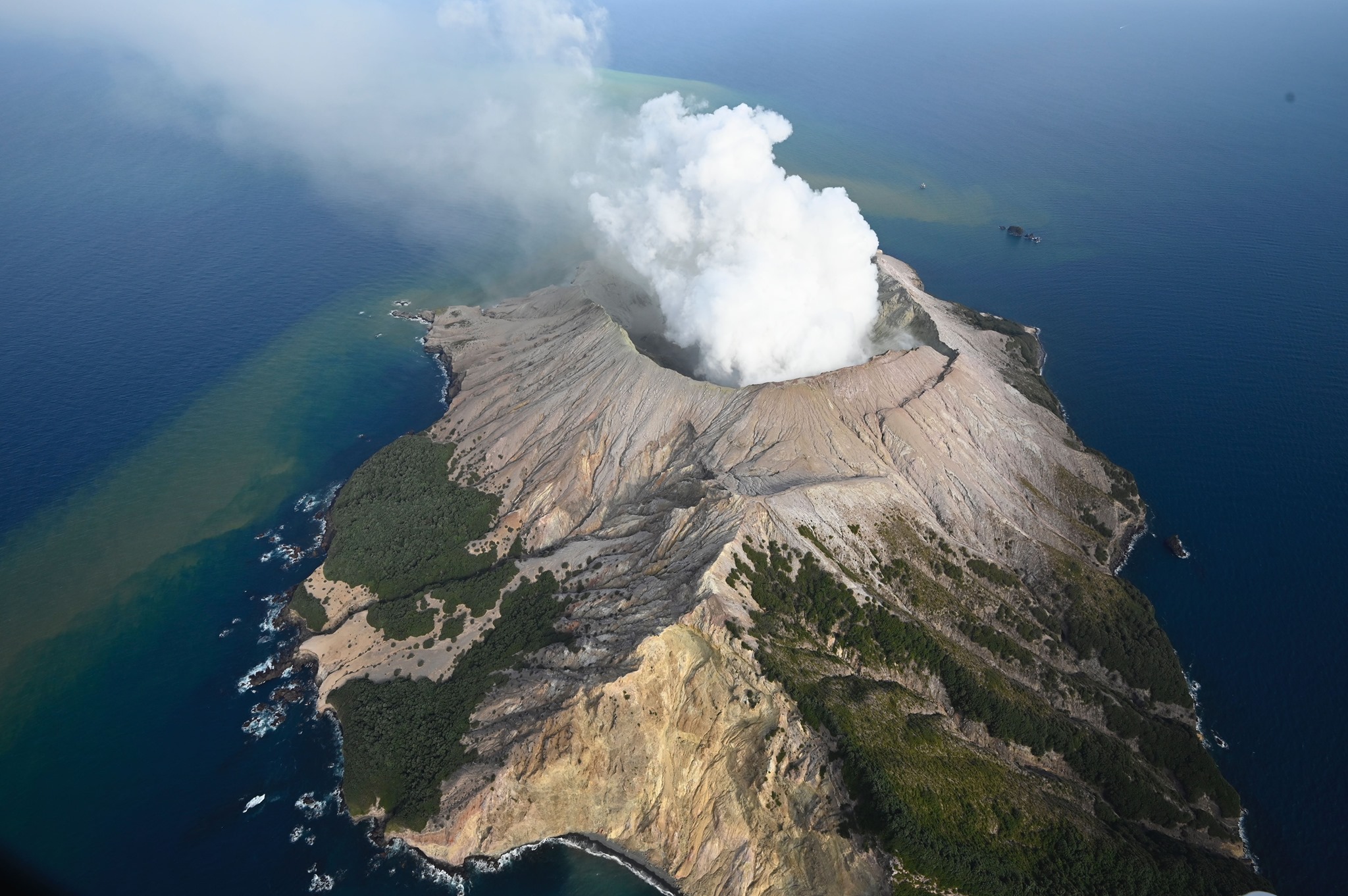
New Zealand , White Island :
Volcanic Alert BulletinWI – 2019/21 , Fri Dec 13 2019 5:30 PM; White Island Volcano
Volcanic Alert Level remains at 2
Aviation Colour Code remains at Orange
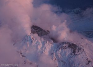
The level of volcanic tremor has declined but remains elevated at Whakaari/White Island. No further eruptions have occurred since Monday 9 December. The Volcanic Alert Level remains at Level 2.
Results from a gas flight on Thursday afternoon (12 December) show levels of volcanic gases emitted from the volcano have increased from those measured on Tuesday (10 December).
Vigorous steam and mud bursts and jetting continue from the active vent area. The combined interpretation of all our data is that magma is degassing at shallow depths and the situation remains highly volatile.
We are updating the eruption probability tabletable, and this will be published on the GeoNet website later this morning.
Some monitoring equipment is partially buried under ash and may stop functioning over the weekend as batteries run out. However, we are still receiving data from the remaining equipment which allows us to monitor the volcano.
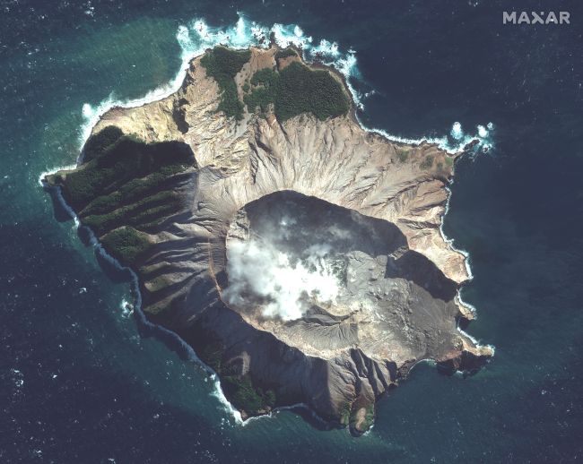
A satellite image of White Island taken on May 12, 2019 (Image credit: Satellite image ©2019 Maxar Technologies).
The level of volcanic tremor has declined but remains elevated at Whakaari/White Island. No further eruptions have occurred since Monday 9 December. The Volcanic Alert Level remains at Level 2.
Since the eruption on Monday, there has been no further eruptive activity. Since this morning volcanic tremor has continued to decline but remains at a high level compared to before the eruption.
The combined interpretation of all our data is still that magma is degassing at shallow depths and the situation remains highly volatile.
We are conducting an overflight this afternoon to make further observations and temperature measurements of the vent area to help us refine our interpretations of the activity.
We will provide daily updates on activity unless the situation changes.
There is an extremely low likelihood of any potential ash affecting the mainland, but people may smell gas, depending on the prevailing wind direction.
The Volcanic Alert Level remains at Level 2.
The Aviation Colour Code remains at Orange.
GNS Science and our National Geohazards Monitoring Centre continue to closely monitor Whakaari/White Island for further signs of activity. Volcanic Alert Level 2 indicates moderate to heightened unrest with potential for eruption hazards.
Source : Geonet / Craig Miller , Duty Volcanologist
Photos :Image satellite © 2019 Maxar Technologies , George Novak .
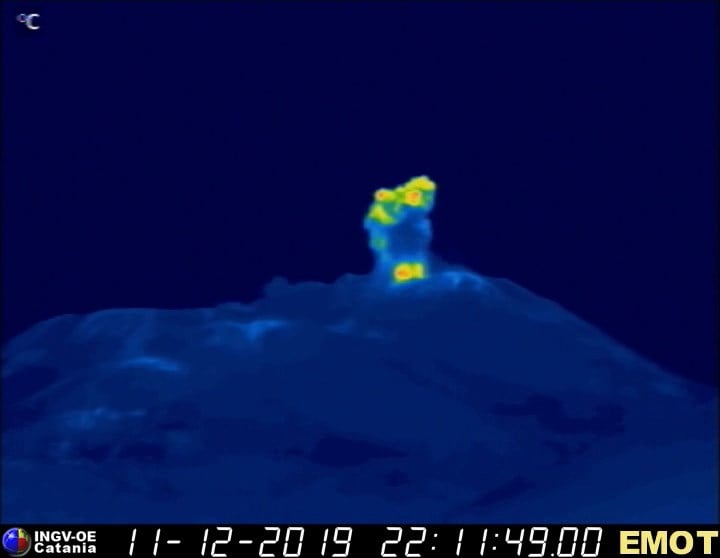
Italy / Sicily, Etna :
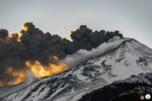
Moderate explosive activity is continuing at the summit craters of #Etna. These images, recorded during the night of 11-12 December 2019, show Strombolian activity at the crater Voragine, at two vents on the New Southeast Crater (NSEC), and at the Northeast Crater. A novelty has been the opening of a new vent on the eastern flank of the « saddle cone » of the NSEC, which since the late evening of 11 December sporadically produces small Strombolian explosions, at times simultaneously, or alternating, with the easternmost vent of the NSEC.
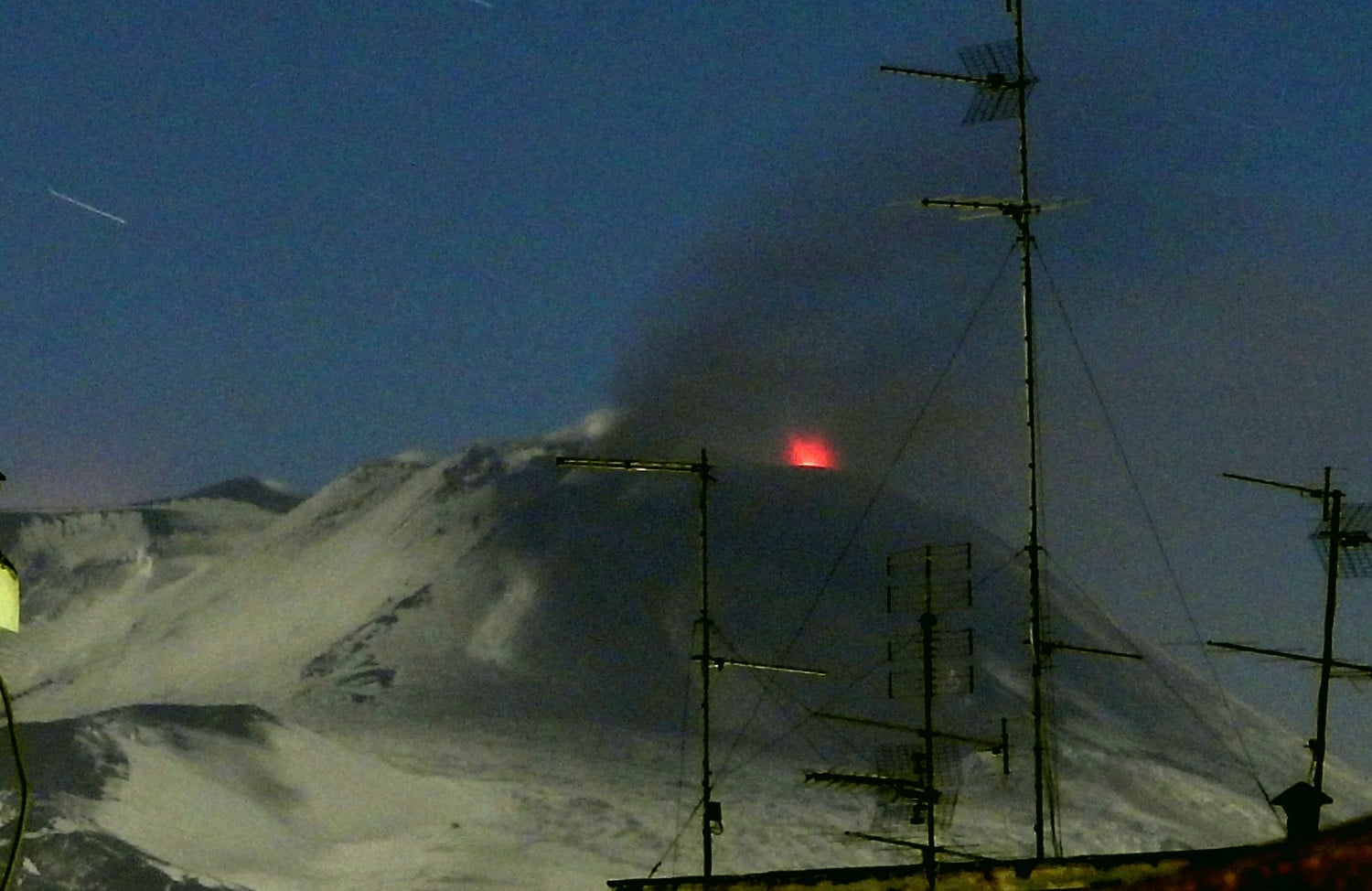
The first photo was taken from the roof of the INGV-Osservatorio Etneo at 01:10 h (local time) on 12 December, showing a Strombolian explosion at the eastern vent of the NSEC. The second image shows an explosion a the new vent on the « saddle cone », recorded by the thermal camera on the Montagnola « EMOT » at 23:11 h (local time) on 11 December.
It should be noted that these phenomena do not represent an increase in the intensity of the eruptive activity, which, on the contrary, seems slightly decreased during the last two days. In addition, the scale of volcanic tremor has decreased considerably since last night. Thus, Etna asserts itself, once again, as an extremely versatile and mysterious volcano which is, moreover, currently, the most active volcano in the world!
Source : INGV Vulcani . Boris Behncke .
Alaska , Shishaldin :
AVO/USGS Volcanic Activity Notice
Current Volcano Alert Level: WATCH
Current Aviation Color Code: ORANGE
Issued: Thursday, December 12, 2019, 8:18 AM AKST
Source: Alaska Volcano Observatory
Location: N 54 deg 45 min W 163 deg 58 min
Elevation: 9373 ft (2857 m)
Area: Aleutians
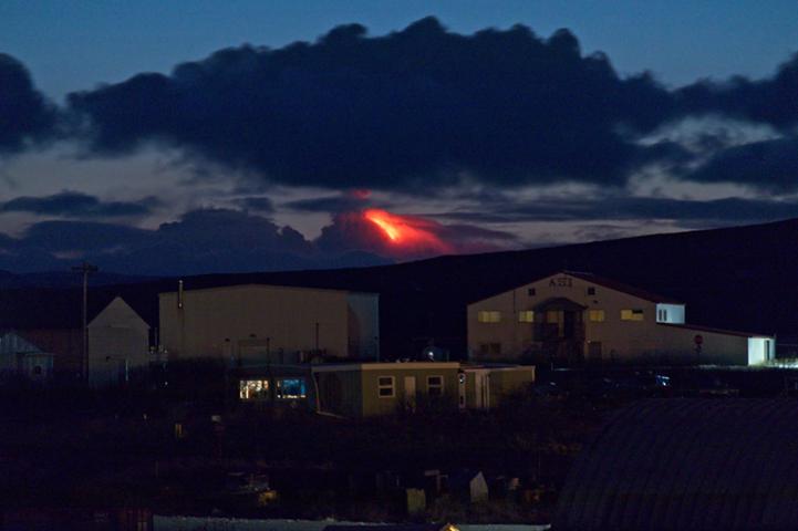
View of the Shishaldin erupting on the evening of December 12, 2019, view of Cold Bay. Photo by Aaron Merculief.
Volcanic Activity Summary:
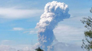
A short-lived explosion from Shishaldin Volcano has produced an ash cloud to 20,000 – 25,000 feet and is moving to the W-NW. A tremor burst was observed in seismic data at 7:10 (16:10 UTC) and had a duration of about 3 minutes. Three lightning stroke were detected. Shishaldin remains at Aviation Color Code ORANGE and Alert Level WATCH. The National Weather Service has issued SIGMET to 25,000 ft above sea level (https://www.weather.gov/aawu/).
Shishadin remains at a heightened level of unrest and explosions may occur with little warning.
Shishaldin is monitored by local seismic and infrasound sensors, satellite data, a web camera, a telemetered geodetic network, and distant infrasound and lightning networks.
Recent Observations:
[Volcanic cloud height] 25,000
[Other volcanic cloud information] Rising above cloud deck moving to the W-NW from Shishaldin at approximately 45 knots.
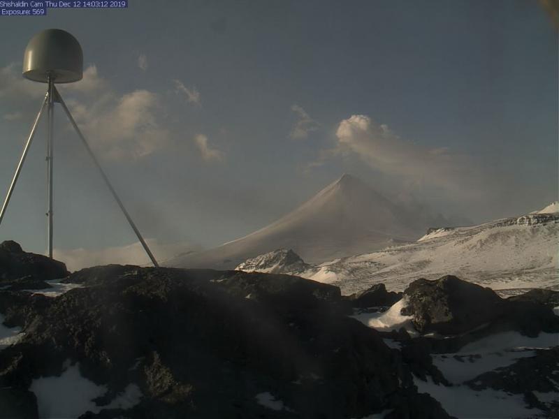
Shishaldin, as seen in AVO’s webcam, Dec 12 2019. Ash visible on flanks from the short-lived explosion earlier this morning (7:10 am AKST).
A short-lived explosion from Shishaldin Volcano occurred earlier this morning at 7:10 AKST (16:10 UTC) and produced an ash cloud to about 25,000 feet above sea level, drifted to the NW and dispersed after a couple of hours. The eruption cloud is visible in a series of GOES satellite images from 16:30 until about 18:00. Three lightning strokes were detected by the Worldwide Lightning Location Network (http://wwlln.net/) between 07:15 and 07:17 AKST (16:15-16:17 UTC). Consistently elevated surface temperatures were seen in satellite data yesterday afternoon and overnight through clouds. The SIGMET issued by the National Weather Service earlier this morning has been cancelled. The ash cloud was associated with a 3-minute period of elevated seismic tremor. Tremor continues to be observed in seismic data at this time indicating that surficial eruption processes are continuing.
Episodic explosions and lava flow front collapses resulting in low-level ash plumes can occur with little warning.
Remarks: Shishaldin volcano, located near the center of Unimak Island in the eastern Aleutian Islands, is a spectacular symmetric cone with a base diameter of approximately 16 km (10 mi). A 200-m-wide (660 ft) funnel-shaped summit crater typically emits a steam plume and occasional small amounts of ash. Shishaldin is one of the most active volcanoes in the Aleutian volcanic arc, with at least 54 episodes of unrest including over 24 confirmed eruptions since 1775. Most eruptions are relatively small, although the April-May 1999 event generated an ash column that reached 45,000 ft above sea level.
Source : AVO.
Photos : Aaron Merculief. AVO Shishaldin webcamera .
Kamchatka , Klyuchevskoy :
VOLCANO OBSERVATORY NOTICE FOR AVIATION (VONA).
Issued: December 13 , 2019
Volcano: Klyuchevskoy (CAVW #300260)
Current aviation colour code: ORANGE
Previous aviation colour code: orange
Source: KVERT
Notice Number: 2019-178
Volcano Location: N 56 deg 3 min E 160 deg 38 min
Area: Kamchatka, Russia
Summit Elevation: 15580 ft (4750 m)
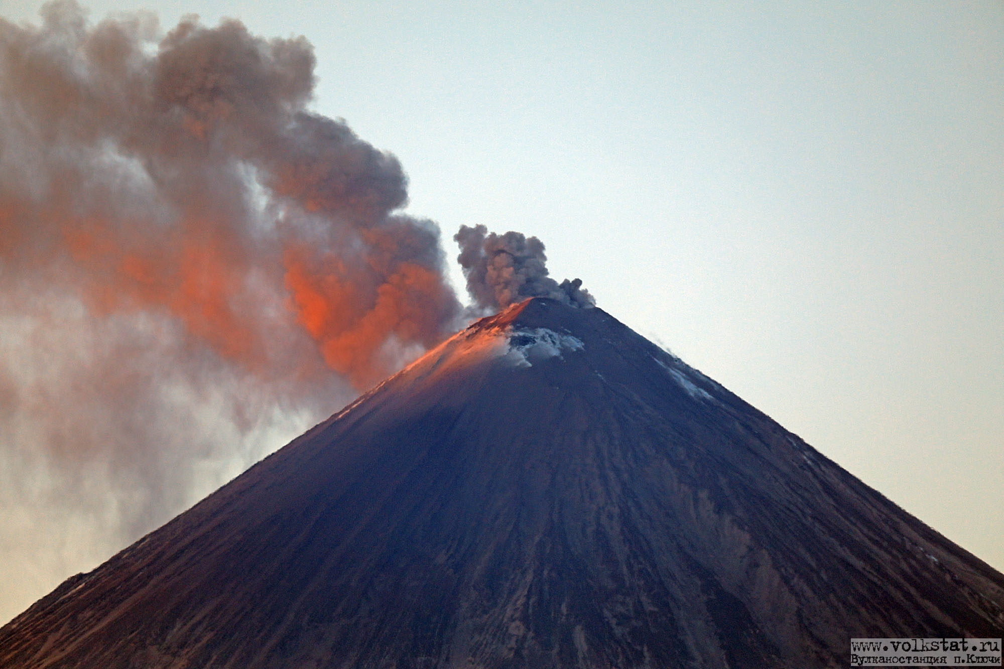
Volcanic Activity Summary:
According to video data, a gas-steam with some amount of ash activity of the volcano continues. An ash plume extended to the northwest of the volcano.
A moderate activity of the volcano continues. Ash explosions up to 16,400-23,000 ft (5-7 km) a.s.l. could occur at any time. Ongoing activity could affect low-flying aircraft.
Volcanic cloud height:
16400-18040 ft (5000-5500 m) AMSL Time and method of ash plume/cloud height determination: 20191213/0230Z – Video data
Other volcanic cloud information:
Distance of ash plume/cloud of the volcano: 6 mi (10 km)
Direction of drift of ash plume/cloud of the volcano: NW
Time and method of ash plume/cloud determination: 20191213/0230Z – Video data
Source : Kvert.
Photo : Volkstat ru.