September 07 , 2022.
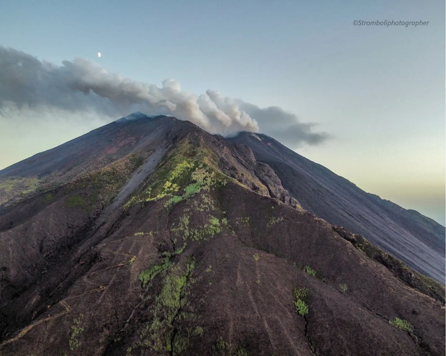
Italy / Sicily , Etna :
MONTHLY BULLETIN, AUGUST 2022 (issue date 06 September 2022)
SUMMARY OF STATUS OF ACTIVITY
In the light of the surveillance data, it is highlighted:
1) VOLCANOLOGICAL OBSERVATIONS: Variable level degassing activity at the summit craters, frequent rumblings from the Bocca Nuova crater.
2) SEISMOLOGY: Seismic activity of fracturing characterized by a swarm in the western sector, started on August 29 (28 events with M > 2.0, Mmax 3.3). Average amplitude of the volcanic tremor on an average level alternating with short periods at high level.
3) INFRASOUND: Variable trend in the rate of occurrence of events, which are mainly located in the Bocca Nuova crater area.
4) DEFORMATIONS OF THE SOIL: The state of inflation of the volcanic edifice persists. There is an increase in velocities at the Monte Crisimo stations, along the Pernicana fault system and at the Sant’Alfio station.
5) GEOCHEMISTRY: SO2 flux at an average level and increasing moderately.
Soil CO2 flux shows average values.
The partial pressure of dissolved CO2 in groundwater shows values in seasonal variability.
Helium data from the latest sampling show no significant changes from previous ones, settling on the high level.
6) SATELLITE OBSERVATIONS: The thermal activity observed by satellite in the summit area was weak.
VOLCANOLOGICAL OBSERVATIONS
The monitoring of the volcanic activity of Etna, during the observation period in question, was carried out by analyzing the images of the network of surveillance cameras of the INGV, Etneo Observatory (INGV-OE) and at through various inspections in the summit area carried out by INGV-OE staff on August 3, 18, 25 and 29.
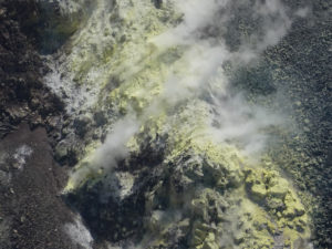
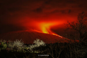
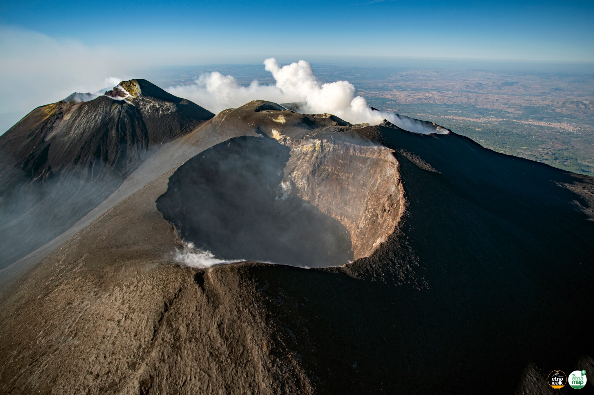
In general, in the period studied, the activity of Etna showed no change compared to that observed after the end of the eruptive activity of May-June 2022, and was characterized by degassing at a variable rhythm at the level of the summit craters. During days with little wind, conspicuous columns of steam often formed, clearly visible even from tens of kilometers away, fed mainly by the degassing of the Bocca Nuova (BN) crater, and to a lesser extent, by the fumarolic activity of the Southeast crater (SEC).
In detail, the Bocca Nuova (BN) crater is characterized by variable and often pulsating intra-crater degassing. Usually, as in previous months, the strongest puffs of gas are accompanied by sonic roars, sometimes audible even a few miles downwind.
During inspections on August 3 and 18, explosions threw pyroclastic material over the rim of the westernmost active vent, as seen by thermal camera measurements and noise from rock falls.
During the third decade of the month, the frequency of Bocca Nuova (BN) explosions temporarily decreased, only to increase again towards the end of the month, in conjunction with fluctuations in volcanic tremor.

Degassing of Etna’s summit craters at various times during August 2022, mainly due to Bocca Nuova and Southeast craters, seen from visual cameras from Monte Cagliato (a), Piedimonte (b, c ) and on the Montagnola (d)
Southeast Crater (SEC) shows fumarolic activity at many locations along the crater rims and in the breccia created when the cone flank collapsed on the evening of February 10, 2022.
The vent that produced explosive activity during the May-June 2022 eruption, located just below the northern rim of the crater, shows modest degassing and modest nocturnal glow.
On the evening of August 26, the lightning intensified several times, although no launch of incandescent pyroclastic material was observed.
Finally, the Northeast Crater (NEC) was the site of a modest collapse which affected part of its northeast inner wall, on the morning of August 2, 2022. This collapse generated a small puff of brown ash , which he lifted a hundred meters. above the crater rim. The floor of the Northeast Crater (NEC) is completely obstructed, as is the neighboring crater of Voragine, where only a few small fumaroles are observed along the edges of the intra-crater cone.
Source : INGV.
Photo : Giuseppe Distefano / , INGV.
Colombia , Purace / Los Coconucos Volcanic Range :
Weekly bulletin of the activity of the Puracé volcano – Los Coconucos volcanic chain
The activity level of the volcano continues at the Yellow Activity Level or (III): changes in the behavior of volcanic activity.
From the analysis and evaluation of the information obtained through the monitoring network of the Puracé volcano – Los Coconucos volcanic chain, during the week between August 30 and September 5, 2022, the COLOMBIAN GEOLOGICAL SERVICE – Volcanological Observatory and Seismological of Popayán informs that:
During the period evaluated, 871 seismic events were recorded, of which 213 were associated with rock fracturing processes (type VT) and 658 with fluid dynamics in volcanic conduits; of these, 568 were classified as long-period type events (LP type), one (1) was associated with both failure mechanisms and fluid dynamics, for which it was classified as hybrid (type HB), two (2) were classified as « Tornillos » type earthquakes (type TO) and 87 as low energy tremor pulses (type TR).
The geodetic network of GNSS (Global Navigation Satellite System) stations for monitoring ground deformation continues to record a process associated with inflation.
In the monitoring of surface activity, the images obtained during the week thanks to the Anambío, Mina, Lavas Rojas, Cerro Sombrero and Curiquinga web cameras showed degassing of the volcanic system, with a white column oriented preferentially towards the North -West.
In terms of volcanic gas monitoring, sulfur dioxide (SO2) flux emissions recorded by telemetry stations continue to show changes in flux, with a maximum emitted of 3,513 t/day for the assessed week. The other instruments for measuring carbon dioxide (CO2) and radon gas (222Rn) in the volcanic influence zone record considerable variations in their concentrations for the period evaluated, which is normal in active volcanic systems.
Magnetic field and infrasound wave monitoring sensors did not record variations associated with changes in volcanic activity.
Based on the above, it is concluded that significant variations in volcanic activity continue to be recorded, in accordance with the behavior expected at activity level III (yellow level), which could evolve towards activity states more important. The Colombian Geological Service continues to monitor the evolution of the volcanic phenomenon and will report any changes that may occur in due course.
Source et photo : SGC.
Italy , Stromboli :
WEEKLY BULLETIN, August 29, 2022 to September 04, 2022. (issue date September 06, 2022)
SUMMARY OF STATUS OF ACTIVITY
In the light of the surveillance data, it is highlighted:
1) VOLCANOLOGICAL OBSERVATIONS: In the period under observation there is no update concerning the volcanological observations of Stromboli following problems of
acquisition of video signals caused by damage to the optical fiber connecting Punta Labronzo and COA. The latest updated data for the period from August 8 to 14, 2022, placed the total explosive activity at a medium-low level, with an intensity of explosions between low and medium in the areas of the North and Center-South craters .
2) SEISMOLOGY: The seismological parameters monitored do not show any significant variations.
3) SOIL DEFORMATIONS: The island’s soil deformation monitoring networks did not show any significant changes to report for the period under review.
4) GEOCHEMISTRY: SO2 flux at an average and increasing level
The flux of CO2 from the soils in the summit zone is on average values.
The C/S ratio in the plume settles on average values (10.9)
Isotope ratio of dissolved helium in thermal wells: There is no update from the July 27, 2022 sampling.
5) SATELLITE OBSERVATIONS: The thermal activity observed by satellite in the summit area was weak.
VOLCANOLOGICAL OBSERVATIONS
In the period under observation, there is no update regarding the volcanological observations of Stromboli, due to problems in the acquisition of video signals caused by the
fiber optic damage connecting Punta Labronzo and COA due to severe weather that hit the island on August 12, 2022. The latest updated data for the period August 8-14, 2022 puts total explosive activity at a low medium-low, with low to medium intensity of explosions in the North and Center-South crater areas.
Source : INGV.
Photo : Stromboli Stati D’animo.
Russia / Kuril Islands , Ebeko :
VOLCANO OBSERVATORY NOTICE FOR AVIATION (VONA)
Issued: September 07 , 2022
Volcano: Ebeko (CAVW #290380)
Current aviation colour code: ORANGE
Previous aviation colour code: orange
Source: KVERT
Notice Number: 2022-107
Volcano Location: N 50 deg 41 min E 156 deg 0 min
Area: Northern Kuriles, Russia
Summit Elevation: 1156 m (3791.68 ft)
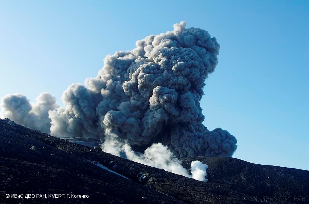
Volcanic Activity Summary:
A moderate eruptive activity of the volcano continues. According to visual data by volcanologists from Severo-Kurilsk, explosions sent ash up to 2.5 km a.s.l., an ash cloud is drifting to the north of the volcano.
This activity of the volcano continues. Ash explosions up to 6 km (19,700 ft) a.s.l. could occur at any time. Ongoing activity could affect low-flying aircraft and airport of Severo-Kurilsk.
Volcanic cloud height:
2500 m (8200 ft) AMSL Time and method of ash plume/cloud height determination: 20220907/0206Z – Visual data
Other volcanic cloud information:
Distance of ash plume/cloud of the volcano: 5 km (3 mi)
Direction of drift of ash plume/cloud of the volcano: N
Time and method of ash plume/cloud determination: 20220907/0206Z – Visual data
Source : Kvert
Photo : T. Totenko , IVS FEB RAS , KVERT.
Iceland , Reykjanes Peninsula:
Yesterday (Sep 6th) at 3:38 am an earthquake of M3.5 was detected just west of Mt. Keilir on Reykjanes peninsula. Few minor earthquakes followed but IMO has not received any felt reports.
At 13:19yesterday (Sep 6th) a M3.1 earthquake occurred 4.6 km west of Landmannalaugar. No reports the earthquake was felt.
On the 21st of August the activity in Meradalir ceased, which is the first time since the eruption started on 3rd of August. The area is still being closely monitored as the activity could resume again.
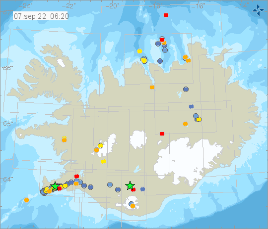
Week overview 29 August – 4 September
Around 580 earthquakes were located last week by the SIL seismic network, a decrease from the previous week when around 650 earthquakes were located. The difference is largely explained by slightly less activity in Reykjanes peninsula, although it continues to be the most active area with over 360 located earthquakes. The largest earthquake of the week was a M3.8 on 3. September that was a part of a swarm on Kolbeinsey Ridge on 3-4. September. Eight earthquakes over M3 were located in the swarm. The largest earthquake on land was a M2.7 in Móhálsadalur on Reykjanes peninsula on 29. August at 12:57. One M2.0 earthquake was located in Hekla this week, 11 by Grímsvötn but no earthquakes were located in Bárðarbunga.
Source et photo : Vedur is.
New Zealand , White Island :
Whakaari/White Island: Volcanic Alert Level raised to Level 2 due to loss of real-time monitoring capability and increased uncertainty. Wed Sep 7 2022 2:00 PM
The recent loss of access to continuous data from Whakaari/White Island means we are effectively unable to distinguish in near real-time between VAL 1 (minor volcanic unrest) and VAL 2 (moderate to heightened unrest). As a result, the Volcanic Alert Level for Whakaari/White Island has been raised to Level 2, not as an indication of a noticed increase in volcanic activity, but as a reflection of the increased level of uncertainty in our interpretation due to the current lack of real-time data.
In addition to conducting regular observation flights and airborne gas measurements, our volcano monitoring capability strongly relies on real-time data collected by permanent instrumentation on volcanoes across New Zealand. The recent loss of real-time access to the data from our last operating earthquake and pressure sensor at Whakaari/White Island has further reduced our ability to closely monitor the level of unrest. We are now effectively unable to distinguish in near real-time between Volcanic Alert Level (VAL) 1 (minor volcanic unrest) and VAL 2 (moderate to heightened unrest), in between our monitoring flights. Therefore, we are raising the VAL to Level 2, not due to a noticed increase in activity, but to acknowledge the greater level of uncertainty in our interpretation due to the current lack of real-time data. We feel this prudent approach more accurately reflects the level of uncertainty about what might be happening undetected at Whakaari/White Island because we do not have this critical real-time data.
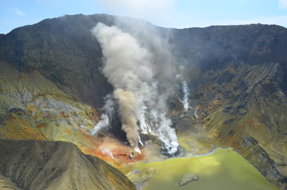
Until we are able to service our on-island equipment and power supplies, we will be increasing the frequency of our gas and observation flights to the island. We also still have intermittent access to webcams images from the island, providing some level of visual monitoring between our flights.
Our most recent observation flight (31 August 2022) indicates the level of activity at the island had remained low, with normal fumarole and gas emissions. Atmospheric conditions have produced tall steam and gas plumes above the island in the morning some days, sometimes visible from the coast.
The monitoring network at Whakaari has consisted of two sites with earthquake and pressure sensors (to detect explosive airwaves), three cameras, two SO2 (sulphur dioxide) gas scanners and two GNSS antenna for measuring ground deformation. Since the 9 December 2019 eruption, the on-island network has not been serviced and power supplies, sensors and cameras have degraded or failed over time. Our near real-time capability has been largely reliant on the on-island earthquake and pressure sensors.
Source et photo : Geonet