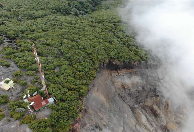
August 28 , 2020 . EN. Costa Rica : Irazu , Ecuador : Sangay , Kamchatka : Sheveluch , Italy : Campi Flegrei .

August 28 , 2020.


Costa Rica , Irazu :

No eruption is reported.
Seismic activity is higher compared to yesterday.
At the time of this report, the winds are blowing south.

The CO2 concentration in the North zone has returned to normal values. The number of landslides recorded by the seismic network showed an exponential increase, especially since August 20 (> 30 events identified on August 23). The acceleration of the main glide is still very strong, with speed increasing by 30% every week. On August 24, the movement speed reached> 20 m / year (horizontal) and ~ 25 m / year (vertical). A movement of more than 20 centimeters is recorded in the last 24 hours. According to photogrammetric measurements, the breaking of the area into blocks has been identified, some moving more than 3 times faster than the reference GPS. Some blocks have a southern movement component.


Seismographs from almost all of the country as well as infrasound sensors from the volcanoes Irazú, Turrialba, Poás and Rincón de la Vieja detected today, August 26, 2020 around 4:00 a.m., signals due to the collapse of a block important in the high outer wall of the western sector of the Irazú volcano, precisely where there are several of the telecommunications towers that are at the top of the Irazú volcano. At least one of the towers (that of channel 23) is partially suspended in the air and is in imminent danger of falling into the canyon of the Sucio river basin.


Staff and residents of Irazú Volcano National Park said they felt ground movement and heard the sound of the collapsed block falling. At the moment, volcanologists from OVSICORI-UNA are in the affected area to document the situation, the damage and the possible consequences using drones. The movement of the block that collapsed today, August 26, 2020, has been detected since 2011 thanks to the GPS network and the OVSICORI-UNA seismographs located on the Irazú and Turrialba volcanoes.

In 2014, several major collapses were detected on the seismographs and infrasound sensors of the OVSICORI-UNA. In 2015, a significant widening of the cracks and an increase in the irregularity of the said block were observed, indicating landslides in the vertical and horizontal planes. In the same year, MINAE issued a recommendation to relocate several of the telecommunication antennas located at the top of the Irazú and near the edge of the landslide (landslide crown) from their sites due to the potential danger of landslide. fast from the block.


During the year 2020, the OVSICORI-UNA recorded an acceleration of the movement of the block which collapsed today, using GPS systems, seismographs and infrasound sensors, and informed the CNE and the staff of the Volcán Irazú National Park on the acceleration of this movement and on the possible collapse to be expected between August and October 2020 in the event of heavy rains and if the level of acceleration of the terrain is maintained.

Source : Ovsicori .

Photos : Teletica.


Ecuador :  Sangay :

Information VOLCÁN SANGAY N ° 094, THURSDAY AUGUST 27, 2020

This August 27, thanks to the images of the ECU911, we can observe the strong activity of the Sangay volcano, with emission of ash and pyroclastic flows in the Southeast ravine. The wind carries the ashes towards the southwest, which could generate moderate ash fall in the province of Chimborazo. This phenomenon has been persistent during the current eruptive period which began in May 2019. It is recommended to take the appropriate measures and receive the information from official sources.


In the morning, on images shared by ECU911, the volcano was observed cloudy. The VAAC recorded 2 ash emission alerts, the direction varied from southwest to west, these emissions reached heights of up to 600 meters above the crater level.

For the past 24 hours, the volcano was from partly cloudy to cloudy, preventing observations of surface activity.
Until the close of this bulletin, there are no reports of possible ash fall. Due to transmission problems at the reference station, seismic data is not available for today.

The Geophysical Institute of the National Polytechnic School is keeping an eye on the activity of the volcano and will report on any changes that may be recorded.

Source : IGEPN.


Kamchatka , Sheveluch :

56.64 N, 161.32 E;
Elevation 10768 ft (3283 m), the dome elevation ~8200 ft (2500 m)
Aviation Colour Code is ORANGE

The extrusive eruption of the volcano continues. Ash explosions up to 32,800-49,200 ft (10-15 km) a.s.l. could occur at any time. Ongoing activity could affect international and low-flying aircraft.

A growth of the lava dome continues, a strong fumarolic activity sometimes with some amount of ash, and an incandescence of the western part of the lava dome and hot avalanches accompanie this process. Satellite data showed a thermal anomaly over the volcano all week, excluding 27 August when the volcano was obscured by clouds; the plume of an resuspended ash extended for 75 km to the east-southeast of the volcano on 24 August.

Source : Kvert .

Photo : Archive Volkstat ru


Italy , Campi Flegrei :

Weekly bulletin from August 17, 2020 to August 23, 2020, (issue date August 25, 2020)

SUMMARY OF THE STATE OF ACTIVITY
In the light of the surveillance data, it is highlighted:
1) SEISMOLOGY: In the week of August 17 to 23, 2020 in the Campi Flegrei region, 3 low energy earthquakes (Mdmax = -0.5) were recorded.
2) DEFORMATIONS: The average value of the lifting speed in the maximum deformation zone, from January 2020, is approximately 6 mm / month. The ascent recorded at the RITE GPS station has been approximately 63.5 cm since January 2011.
3) GEOCHEMISTRY: The soil CO2 fluxes measured during the period studied did not show any significant changes after the drop in values recorded in early May, probably
linked to local variations of the transmission site measured by the station. The temperature of the main fumarole of Pisciarelli showed an average value of about 115 ° C.

GEOCHEMISTRY
The values ​​of the CO2 flux from the soil continuously recorded by the FLXOV8 station in the Pisciarelli area (north-eastern outer slope of the Solfatara), highlight the persistence of multi-year trends already identified previously (see monthly reports). Soil CO2 fluxes measured last week did not show any significant changes after the drop in values ​​recorded in early May, probably linked to local variations in the emission site measured by the station.
In the period from August 10 to 16, 2020, the temperature of the main fumarole of Pisciarelli recorded continuously showed an average value of ~ 115 ° C, in line with the values ​​recorded in previous periods.
It should be noted that this fumarole being a constantly evolving natural system, with macroscopic variations of the emission site, the temperature recorded continuously may not always coincide with the maximum emission temperature.

Source : INGV .

Read the article :  http://www.ov.ingv.it/ov/bollettini-campi-flegrei/Bollettino_Flegrei_2020_08_25.pdf

Photo : Manuel Mauer / Wikipédia

28 Aout 2020. FR . Costa Rica : Irazu , Equateur :  Sangay : Kamchatka : Sheveluch , Italie : Campi Flegrei .

28 Aout 2020.


Costa Rica , Irazu :

Aucune éruption n’est signalée.
L’activité sismique est plus élevée par rapport à hier.
Au moment de ce rapport, les vents soufflent vers le Sud.

La concentration de CO2 dans la zone Nord est revenue à des valeurs normales. Le nombre de glissements de terrain enregistrés par le réseau sismique a présenté une augmentation exponentielle,
notamment depuis le 20 août (> 30 événements identifiés le 23 août). L’accélération du glissement principal est toujours très forte, la vitesse augmentant de 30% chaque semaine. Le 24 août, la vitesse de déplacement a atteint> 20 m / an (horizontal) et ~ 25 m / an (vertical). Un mouvement de plus de 20 centimètres est enregistré dans les dernières 24 heures. Grâce aux mesures photogrammétriques, la rupture de la zone en blocs a été identifiée, certains se déplaçant plus de 3 fois plus vite que le GPS de référence. Certains blocs ont une composante de mouvement Sud.


Les sismographes de la quasi-totalité du pays ainsi que les capteurs infrasons des volcans Irazú, Turrialba, Poás et Rincón de la Vieja ont détecté aujourd’hui 26 août 2020 vers 4h00 du matin, des signaux dus à l’effondrement d’un bloc important dans le haut mur externe du secteur Ouest du volcan Irazú, là précisément où se trouvent plusieurs des tours de télécommunications qui se trouvent au sommet du volcan Irazú. Au moins une des tours (celle du canal 23) est partiellement suspendue dans les airs et est en danger imminent de tomber dans le canyon du bassin de la rivière Sucio.


Le personnel et les habitants du parc national du volcan Irazú ont déclaré avoir ressenti un mouvement du sol et entendu le son produit par la chute du bloc effondré. En ce moment, des volcanologues de l’OVSICORI-UNA sont dans la zone touchée pour documenter la situation, les dommages et les conséquences possibles à l’aide de drones. Le mouvement du bloc qui s’est effondré aujourd’hui, 26 août 2020, est détecté depuis 2011 grâce au réseau GPS et aux sismographes de l’OVSICORI-UNA situés sur les volcans Irazú et Turrialba.

En 2014, plusieurs effondrements majeurs ont été détectés sur les sismographes et les capteurs infrasons de l’OVSICORI-UNA. En 2015, un élargissement significatif des fissures et une augmentation de l’irrégularité dudit bloc ont été observés, indiquant des glissements de terrain dans les plans vertical et horizontal. La même année, le MINAE a émis une recommandation de déplacer plusieurs des antennes de télécommunication situées au sommet de l’Irazú et à proximité du bord du glissement de terrain (couronne de glissement de terrain) de leurs sites en raison du danger potentiel de glissement rapide du bloc.


Au cours de l’année 2020, l’OVSICORI-UNA a enregistré une accélération du mouvement du bloc qui s’est effondré aujourd’hui, à l’aide de systèmes GPS, de sismographes et de capteurs d’infrasons, et a informé le CNE et le personnel du Parc National du Volcán Irazú sur l’accélération de ce mouvement et sur l’éventuel effondrement à prévoir entre août et octobre 2020 en cas de fortes pluies et si le niveau d’accélération du terrain est maintenu.

Source : Ovsicori .

Photos : Teletica.


Equateur :  Sangay :

Information  VOLCÁN SANGAY N ° 094 , JEUDI 27 AOÛT 2020

Ce 27 août, grâce aux images de l’ECU911, on peut observer la forte activité du volcan Sangay, avec émission de cendres et coulées pyroclastiques dans le ravin Sud-est. Le vent transporte les cendres vers le Sud-Ouest, ce qui pourrait générer des chutes de cendres modérées dans la province de Chimborazo. Ce phénomène a été persistant au cours de la période éruptive actuelle qui a débuté en mai 2019. Il est recommandé de prendre les mesures appropriées et de recevoir les informations de sources officielles.


Dans la matinée, sur des images partagées par l’ECU911, le volcan a été observé nuageux . Le VAAC a enregistré 2 alertes d’émissions de cendres, la direction variait du Sud-Ouest à l’Ouest, ces émissions ont atteint des hauteurs allant jusqu’à 600 mètres au-dessus du niveau du cratère.

Les dernières 24 heures, le volcan était de partiellement nuageux à nuageux, empêchant les observations de l’activité de surface.
Jusqu’à la clôture de ce bulletin, il n’y a aucun rapport de chute de cendres possible. En raison de problèmes de transmission à la station de référence, les données sismiques ne sont pas disponibles pour aujourd’hui.

L’Institut géophysique de l’École nationale polytechnique garde un œil sur l’activité du volcan et rendra compte des changements qui pourraient être enregistrés.

Source : IGEPN.


Kamchatka , Sheveluch :

56,64 N, 161,32 E;
Élévation 10768 pi (3283 m),  élévation du dôme ~ 8200 pi (2500 m)
Code couleur de l’aviation : ORANGE

L’éruption extrusive du volcan se poursuit. Des explosions de cendres jusqu’à 32,800-49,200 ft (10-15 km)d’altitude pourraient survenir à tout moment. L’activité en cours pourrait affecter les aéronefs internationaux volant à basse altitude.

La croissance du dôme de lave se poursuit, une forte activité de fumerolles parfois avec une certaine quantité de cendres, une incandescence de la partie Ouest du dôme de lave et des avalanches chaudes accompagnent ce processus. Les données satellitaires ont montré une anomalie thermique sur le volcan toute la semaine, à l’exception du 27 août lorsque le volcan a été obscurci par les nuages; le panache de cendres remises en suspension s’est étendu sur 75 km à l’Est-Sud-Est du volcan le 24 août.

Source : Kvert .

Photo : Archive Volkstat ru


Italie , Campi Flegrei :

Bulletin hebdomadaire du 17 Aout 2020 au 23 Aout 2020, (date d’émission 25 août 2020)

RÉSUMÉ DE L’ÉTAT D’ACTIVITÉ
À la lumière des données de surveillance, il est mis en évidence:
1) SISMOLOGIE: Dans la semaine du 17 au 23 août 2020 dans la région des Campi Flegrei, 3 tremblements de terre de basse énergie (Mdmax = -0,5) ont été enregistrés.
2) DEFORMATIONS: La valeur moyenne de la vitesse de levage dans la zone de déformation maximale, à partir de janvier 2020, est d’environ 6 mm / mois. La remontée enregistrée à la station GPS RITE est d’environ 63,5 cm depuis janvier 2011.
3) GÉOCHIMIE: Les flux de CO2 du sol mesurés au cours de la période étudiée n’ont pas montré de changements significatifs après la baisse des valeurs enregistrée début mai, probablement
liées aux variations locales du site d’émission mesurées par la station. La température de la fumerolle principale de Pisciarelli  a montré une valeur moyenne d’environ 115 ° C.

GÉOCHIMIE
Les valeurs du flux de CO2 du sol enregistrées en continu par la station FLXOV8 dans la zone de Pisciarelli (versant extérieur Nord-Est de la Solfatara), mettent en évidence la persistance des tendances pluriannuelles déjà identifiées précédemment (voir rapports mensuels). Les flux de CO2 du sol mesurés la semaine dernière n’ont pas montré de changements significatifs après la baisse des valeurs enregistrée début mai, probablement liée aux variations locales du site d’émission mesurées par la station.
Dans la période du 10 au 16 août 2020, la température de la principale fumerolle de Pisciarelli enregistrée en continu a montré une valeur moyenne de ~ 115 ° C, en ligne avec les valeurs enregistrées lors des périodes précédentes.
Il est à noter que cette fumerolle étant un système naturel en constante évolution, avec des variations macroscopiques du site d’émission, la température enregistrée en continu peut ne pas toujours coïncider avec la température maximale d’émission.

Source : INGV .

Lire l’article :  http://www.ov.ingv.it/ov/bollettini-campi-flegrei/Bollettino_Flegrei_2020_08_25.pdf

Photo : Manuel Mauer / Wikipédia