April 25 , 2024.
Indonesia , Ruang :
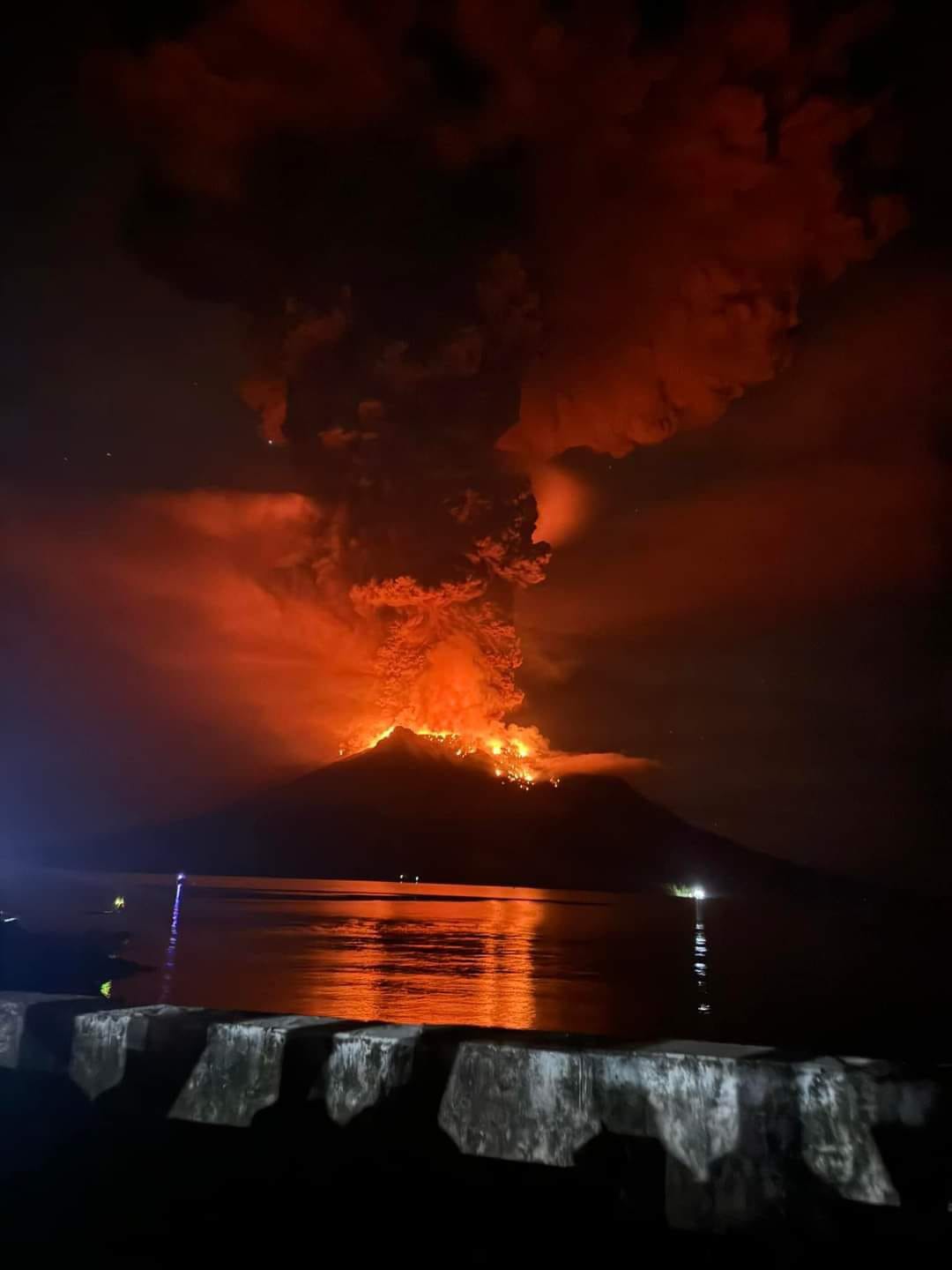
PVMBG raised the Alert Level for Ruang to 2 (on a scale of 1-4) at 1300 on 16 April due to intensifying seismicity. A minor eruption began at around 1337 on 16 April and produced dense white emissions; at 1600 the Alert Level was raised to 3 (on a scale of 1-4). Explosive activity began at 2145 and ash plumes rose 2 km above the summit. Activity continued to escalate. An explosive pulse was recorded at 0108 on 17 April. According to the Darwin VAAC ash plumes had risen to 9.1 km (30,000 ft) a.s.l. and drifted W by 0230, and at 0300 they reached 12.2 km (40,000 ft) a.s.l. and detached from the summit. Ash plumes at a lower altitude of 4.6 km (15,000 ft) a.s.l. drifted WSW. BNPB reported that 828 people from Pumpente and Laingpatehi villages evacuated to neighboring Tagulandang Island to the NE and the communication network in Laingpatehi village was non-operational. Photos showed incandescent material being ejected above the summit, incandescent material on the flanks, pyroclastic density currents descending the flanks, and dense ash plumes with lightning rising into dark, nighttime skies. Another explosive pulse was recorded at 0505 according to PVMBG, and the VAAC noted that by 0600 ash plumes had risen to 13.7 km (45,000 ft) a.s.l. and drifted W and NW. The plume was detached from the summit by 0713. Additional smaller eruptive events produced ash plumes that rose to 1.5 km (5,000 ft) a.s.l. and drifted E.
PVMBG recorded bigger eruptive pulses at 1800 and 2015 on 17 April. Roaring and booming noises were sometimes heard, with gray-to-black ash plumes at 2015 and a felt earthquake. According to the VAAC ash plumes rose to 15.2 km (50,000 ft) a.s.l. by 2000 and at least to 19.2 km (63,000 ft) a.s.l. by 2020; the plumes drifted NW. PVMBG raised the Alert Level to 4, the highest level, at 2100 on 17 April noting that seismicity continued to increase, ash plumes were getting taller, and incandescent rocks were ejected as far as 5 km with some reaching Tagulandang Island. The public was warned to stay 6 km away from Ruang’s main crater. Several residents in Tagulandang were hit with tephra and some received medical treatment according to BNPB. Ashfall was recorded in as many as 10 villages in two sub-districts on Tagulandang and in several sub-districts of North Minahasa Regency (75 km SSW) including West Likupang, Wori, East Likupang, and South Likupang. Communication networks in Lumbo Village on Tagulandang were not properly functioning. An estimated 6,045 people living in the W part Tagulandang evacuated. According to a news article, there was damage to more than 3,000 homes, two churches, and an elementary school.
Multiple ash layers were identified in a satellite image 2310 on 17 April according to the VAAC; ash at 16.8 km (55,000 ft) a.s.l. drifted NW and E and ash at 14.3 km (47,000 ft) a.s.l. drifted WSW. At 0310 on 18 April ash plumes rose to 12.2 km and drifted WNW and W and detached from the volcano by 0600; earlier high-level plumes continued to expand as they drifted NW. According to a news report the Sam Ratulangi International Airport, 98 km SW in Manado, North Sulawesi, closed on 18 April due to the presence of ash.
The VAAC continued to track the plumes; lower-altitude plumes at 7.6 km (25,000 ft) a.s.l. drifted SE. The higher plumes, between 10.7-15.2 km (35,000-50,000 ft) a.s.l., continued to drift NW and WNW and had dissipated by 1710 on 19 April, though sulfur dioxide continued to be tracked W. Weather clouds began to obscure the plumes. On 19 April PVMBG reported that ash plumes rose 400-750 m above the summit and drifted S. During 20-21 April the VAAC issued notifications of ash plumes rising 1.5-2.1 km (5,000-7,000 ft) a.s.l. and drifting S and SW based on satellite images and information from PVMBG. The closure of the Sam Ratulangi International Airport affected 150 flights and about 19,085 passengers as of 20 April based on a news report; the airport resumed operations at noon on 22 April. PVMBG reported that during 21-23 April dense white steam-and-gas plumes rose as high as 200 m and drifted SW, W, and NW. The Alert Level was lowered to 3 at 0900 on 22 April because activity had decreased. Residents were warned to stay 4 km away from the crater.
Sources : Pusat Vulkanologi dan Mitigasi Bencana Geologi (PVMBG, also known as CVGHM), Badan Nacional Penanggulangan Bencana (BNPB), Darwin Volcanic Ash Advisory Centre (VAAC), Antara News, Antara News, Tempo, VOI , GVP.
Photos : PVMBG , Jro Yudhiani ( archives).
Iceland , Reykjanes Péninsula :
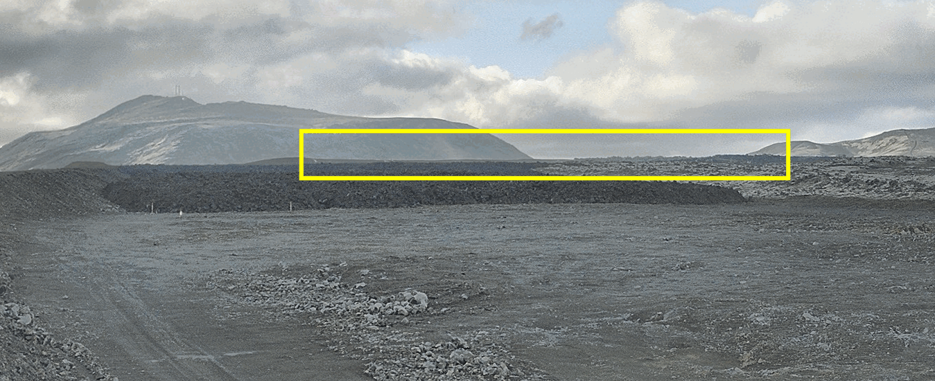
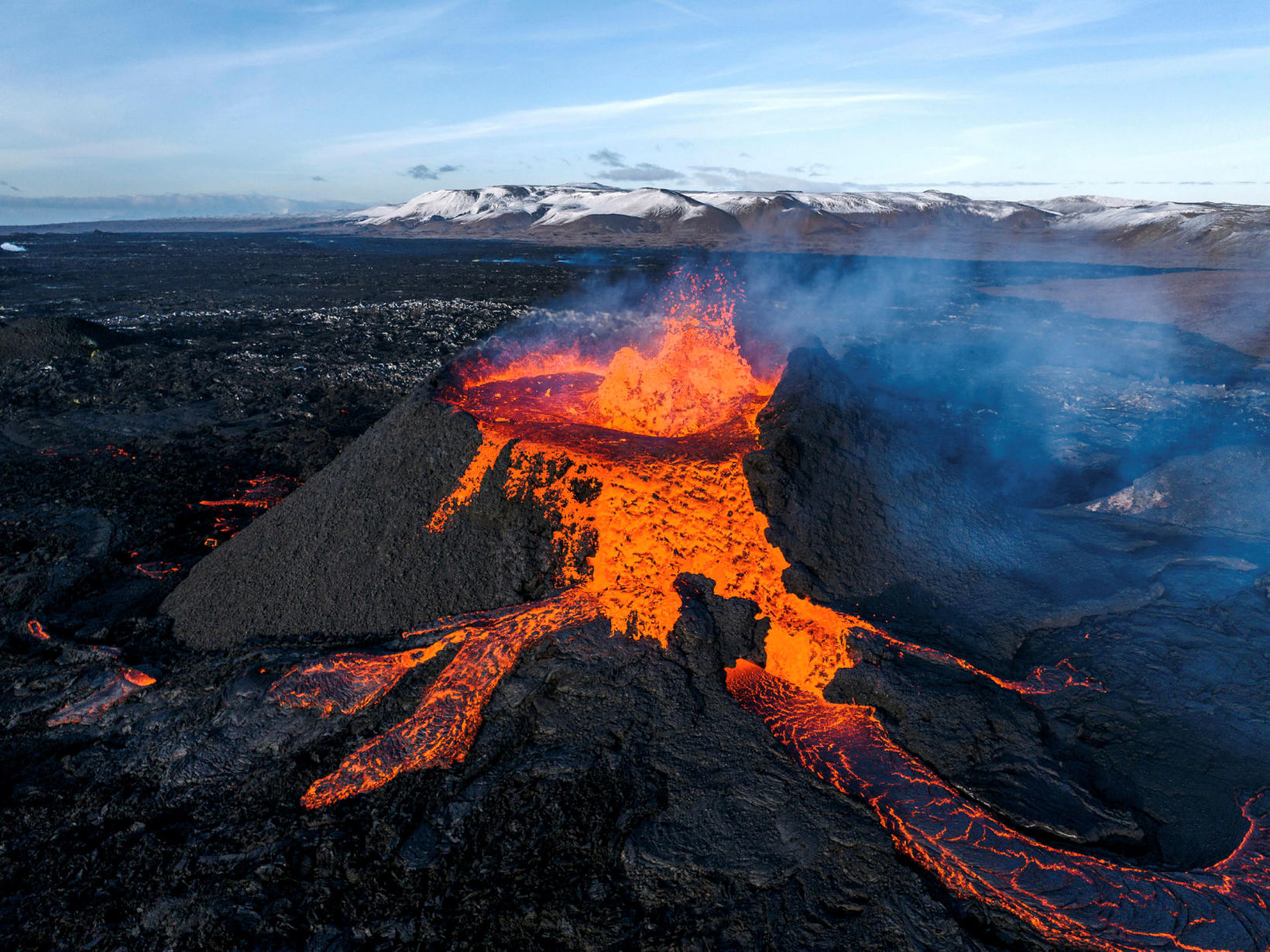
The eruption continues in Sundhnúkur crater row . The lava field is becoming thicker close to the barrier East of Grindavík
The eruption continues from the single vent which formed just East of Sundhnúkur, in a similar manner since 5 April. Lava continues to extrude and propagate towards the South along open channels, which are clearly visible from the cameras. The lava is also travelling longer distances from the crater through a network of closed tubes, which prevents the lava from cooling by direct contact with the atmosphere. The sector of the lava field which has been propagating towards the South, and reached the protective barriers built East of Grindavík town, has been thickening in the past few days, as shown in the images below. The images show the differences in the lava field profile between 18 and 23 April. The image at the top is taken from the camera owned by the Icelandic Civil Protection which is located at the barrier East of Grindavík and looks toward the part of the lava field which propagated towards Suðurstandavegur at the beginning of the eruption.
Estimates of the lava extrusion rate show values between 3-4 m3/s since the beginning of April. The last measurements were made on 15 April, so we are now waiting for new acquisitions which will be available next week, to shed light on the level of the current activity and to understand if there have been any significant changes.
The ground uplift measured around the Svartsengi region continues, indicating that magma accumulates at depth at a stable rate and the total inflow to the reservoir is greater than the outflow feeding the eruption. By using analytical models, constrained by both GNSS and InSAR data, it is assessed that between 7-8 million m3 of magma has been recharged to the Svartsengi reservoir since the eruption commenced on 16 March. In previous events, magma started propagating as dike intrusions from the reservoir at 4-5 km depth towards the surface when a threshold of about 8-13 million m3 of recharged magma was reached.
As long as the magma continues accumulating in the Svartsengi reservoir, the likelihood for a significant escalation in the eruptive activity in Sundhnúk crater row increases.
New eruptive fissures may open in the area between Stóra-Skógfells and Hagafells and/or the current eruptive vent may enlarge because of a sudden increase in magma flow rate, which might reach levels comparable to those observed at the beginning of the past four eruptions which occurred in the area. If this happens, very short precursors, if any, are expected.
It is also possible that if more magma starts propagating from the Svartsengi reservoir to the Sundhnúks crater row, this could happen gradually until a balance between the inflow rate at depth and the extrusion rate at the surface is reached.
There is also the possibility that a new dike intrusion will result in the opening of additional eruptive fissures in areas other than between Stóra-Skógfells and Hagafells. This scenario is, however, considered less likely than those previously stated, and if this happens, longer and more intense precursors are expected to occur.
Source : IMO
Photos : IMO , Hörður Kristleifsson
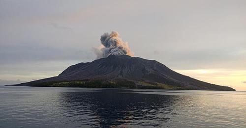
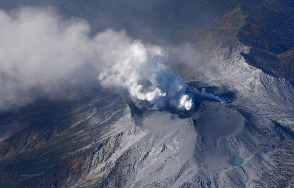
Indonesia , Ibu :
An eruption of Mount Ibu occurred on Wednesday, April 24, 2024 at 11:53 a.m. WIT with the height of the ash column observed at ±800 m above the summit (±2,125 m above sea level ). The ash column was observed to be gray with thick intensity, oriented towards the West. This eruption was recorded on a seismograph with a maximum amplitude of 28 mm and a duration of 36 seconds

PVMBG reported that Ibu continued to erupt during 17-23 April. White-and-gray ash plumes rose 200-2,500 m above the summit and drifted in multiple directions on 17 and 21 April. White steam-and-gas plumes rose 200-600 m above the summit and drifted in multiple directions on the other days. The Alert Level remained at 2 (the second highest level on a four-level scale), with the public advised to stay outside of the 2 km hazard zone and 3.5 km away from the N area of the active crater.
Source and photo : Pusat Vulkanologi dan Mitigasi Bencana Geologi (PVMBG, also known as CVGHM) , GVP
Japan , Suwanosejima :
JMA reported that eruptive activity at Suwanosejima’s Ontake Crater continued during 15-22 April. Crater incandescence was observed in webcam images nightly. No explosions were detected but ashfall was reported in Toshima village (3.5 km SSW); dates were not specified. The Alert Level remained at 2 (on a 5-level scale) and the public was warned to stay at least 1.5 km away from the crater.
The 8-km-long island of Suwanosejima in the northern Ryukyu Islands consists of an andesitic stratovolcano with two active summit craters. The summit is truncated by a large breached crater extending to the sea on the E flank that was formed by edifice collapse. One of Japan’s most frequently active volcanoes, it was in a state of intermittent Strombolian activity from Otake, the NE summit crater, between 1949 and 1996, after which periods of inactivity lengthened. The largest recorded eruption took place in 1813-14, when thick scoria deposits covered residential areas, and the SW crater produced two lava flows that reached the western coast. At the end of the eruption the summit of Otake collapsed, forming a large debris avalanche and creating an open collapse scarp extending to the eastern coast. The island remained uninhabited for about 70 years after the 1813-1814 eruption. Lava flows reached the eastern coast of the island in 1884. Only about 50 people live on the island.
Source: Japan Meteorological Agency (JMA) , GVP.
Photo : Ontake , Masanori Genko
Colombia , Puracé – Chaîne volcanique Los Coconucos :
Weekly activity bulletin: Puracé Volcano – Los Coconucos volcanic chain
From the monitoring of the activity of the VOLCANIC CHAIN PURACE VOLCANO – LOS COCONUCOS, the MINISTRY OF MINES AND ENERGY, through the COLOMBIAN GEOLOGICAL SERVICE (SGC), reports that:
During the week of April 16-22, 2024, seismic activity remained at levels similar to those recorded over the past four months, both in seismic energy released and in the number of events. Fracture earthquakes continued to be located mainly on the southeast flank of the Puracé volcanic building, with depths between 1 and 4 km and magnitudes less than 0.7 ML, while earthquakes associated with fluids were located in two areas: one below the north-west flank of the Puracé volcano with depths less than 1 km, and another of lesser importance to the south-east of it, under the Piocollo and Curiquinga volcanoes, at depths included between 2 and 6 km.
During the period evaluated, the slow deformation process that began in April 2022 between the Puracé and Curiquinga volcanoes continues to be recorded. Likewise, the concentration of carbon dioxide (CO2) maintains a trend above the known reference values for the Puracé volcano and the increase in the flux of sulfur dioxide (SO2) detected in previous weeks continues to be observed.
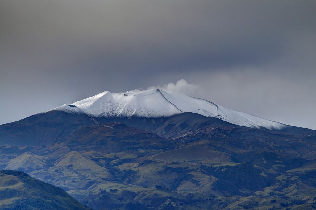
Images obtained using installed cameras show that significant degassing of the volcanic system continues.
Other parameters measured for the assessment of volcanic activity showed no notable changes during the assessed period.
From the SGC we call on people who visit the Puracé National Natural Park not to approach the upper part of the Puracé and Curiquinga volcanoes, given that the increase in gas emissions into the atmosphere can cause problems of health.
The alert status for volcanic activity remains at: YELLOW ALERT: ACTIVE VOLCANO WITH CHANGES IN THE BEHAVIOR OF THE BASE LEVEL OF MONITORED PARAMETERS AND OTHER MANIFESTATIONS.
Source : SGC
Photo : José M. Arboleda