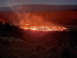
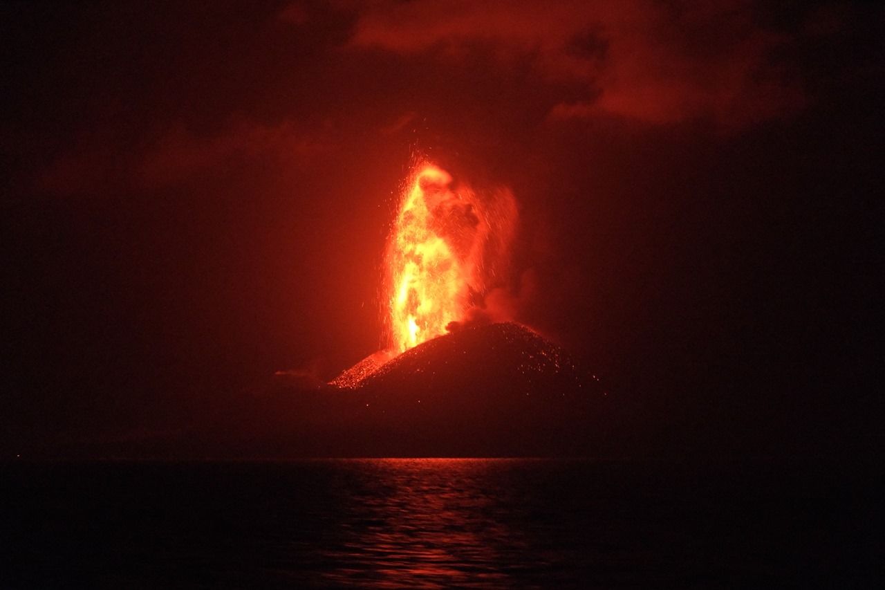
Alaska : Makushin :
53°53’24 » N 166°55’30 » W,
Summit Elevation 5906 ft (1800 m)
Current Volcano Alert Level: ADVISORY
Current Aviation Color Code: YELLOW
Small earthquakes have continued throughout the week at Makushin Volcano. The earthquakes are occurring within an area about 6 miles (10 km) east of the summit at a depth of about 5 miles (8 km) and are part of a sequence that began on June 15, 2020. This week, seismicity has been variable, but earthquakes are now much lower in magnitude and frequency than the first few weeks of the sequence. At this time, the earthquake rate is approaching but remains slightly above background. No signs of unusual activity have been noted at the surface. A few clear web-camera views of the summit this week showed typical steaming from the summit crater.
The exact cause of this increased earthquake activity, in terms of possible volcanic or tectonic processes, remains uncertain at this time. Because of the distance and depth of the locations of the earthquakes from the summit of Makushin Volcano, and the absence of other forms of volcanic unrest such as increased gas emissions, or ground deformation, there is no indication that the present earthquake sequence will necessarily lead to a volcanic eruption.
Source : AVO
Photo : Read, Cyrus , 2017 .
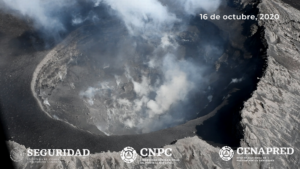
Japan , Nishinoshima :
Nishinoshima is a volcanic island located in the Pacific Ocean about 1,000 kilometers south of central Tokyo. Its existence has long been known, but it erupted for the first time since its history in 1973. Although activity calmed down, it resumed in 2013 for the first time in about 40 years. After that, the eruption repeated itself while gradually reducing in scale.
However, this activity, which started again at the end of last year, turned around and became more intense. According to data from the Himawari 8 weather satellite, the amount of lava ejected per day is three to four times more than in 13 to 15 years. At its peak at the end of June of this year, it was more than 20 times higher, at 4.62 million cubic meters.
The area of the island is enlarged by a large amount of lava. According to satellite data from the Meteorological Research Institute of the Japan Meteorological Agency, its area has increased by 40 percent in just over a year, from 2.89 square kilometers in May 2019 to about 4.1 square kilometers on August 14 of this year. The island, once a few hundred square meters, is now over two kilometers in diameter.
The style of the eruption is also changing. Until June, the lava was mainly ejected, but at the end of July, a large amount of volcanic ash started to be generated, and the entire island was covered with brown ash several meters thick. It is also believed that plants and seabird nests that began to take hold after the eruption subsided were also buried.
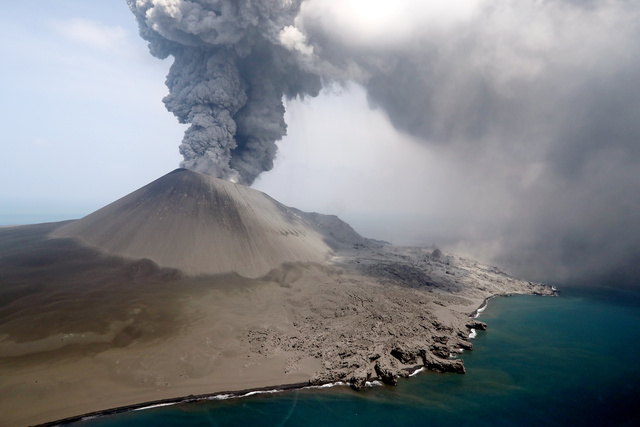
In July, the Japan Meteorological Agency analyzed volcanic ash collected by ships and found that the proportion of silicon dioxide (silica) contained in volcanic ash increased from about 60% to about 55%, and the proportion magnesium and calcium increased in density.
The deeper the crust, the higher the density at high pressure, and the magma that is the source of volcanic ash is also at the same level as the surrounding density. Therefore, the dense magma that was recently ejected appears to have come from a deep place. « After 13 years, the activity seemed to gradually decrease, but in the subsoil, the deep magma seems to be gradually rising, » said Fukae Outfield, associate professor of volcanic geology at the Institute for Seismological Research.
Source : Asahi.com via Sherine France.
Read the article : https://www.asahi.com/articles/ASN8V6JJSN87ULBJ013.html?fbclid=IwAR1DIi_XHufPYW97yuVPlcJApd-8VfHNItSOlY3axayznbRHSoGQqSm8sxM
Photos : JMA ( 07 / 2020 ),
Costa Rica , Turrialba / Poas / Rincon de la Vieja :
Daily report of the state of volcanoes. OVSICORI-UNA, Date: 08/26/2020
Updated at: 12:59:00.
Turrialba volcano
No eruption is reported.
Seismic activity is similar compared to yesterday.
At the time of this report, the winds are blowing to the southwest.
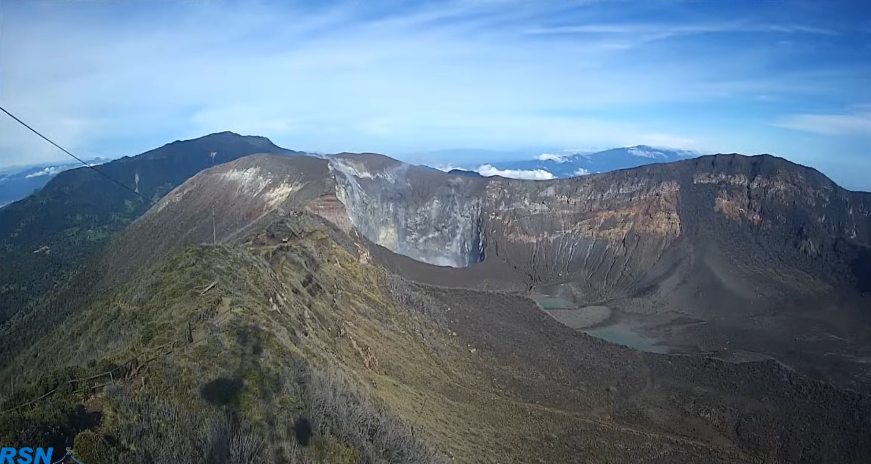
Seismographs record relatively few long-period (LP) type earthquakes linked to the transport of fluids (water, steam, gas). The MultiGAS near real-time automatic gas measurement system indicates low SO2 content (no more than 6 ppm) and low H2S level (H2S / SO2 = 0.2). Thus, the flow of magmatic gases remains very low on the Turrialba volcano. The last time NASA’s AURA satellite detected SO2 gas emitted by the Turrialba was on August 1, 2020, a relatively small mass of around 22 tonnes of SO2.
Poas volcano
No eruption is reported.
Seismic activity is similar compared to yesterday.
At the time of this report, the winds are blowing south.
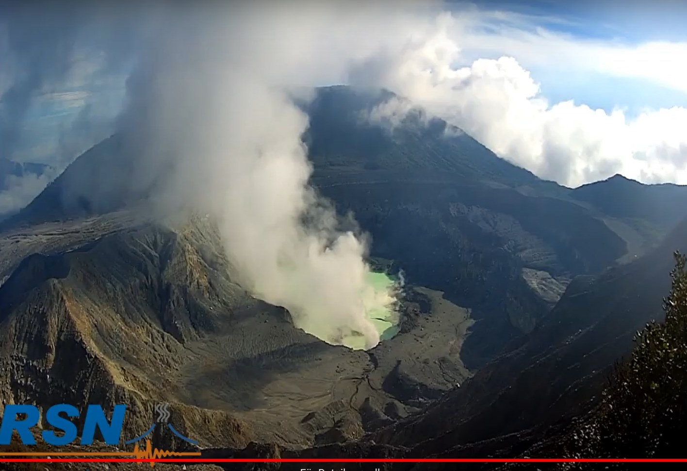
Seismographs do not record volcanic seismic signals but signals related to environmental noise such as rain, lightning, human activities, etc. Most of the fumaroles are underwater in the hyper-acidic lake which is currently pistachio green in color and with a water level that has increased due to the heavy rains observed in August 2020. Boca B fumarole (or Boca Azufrada) is partially out of the water and generates a plume of water vapor and sulphurous gas that reaches about 50 meters above the crater floor. In August 2020, the lake remains very acidic (pH = 0), and hot (42 ° Celsius) but its waters have been very strongly diluted by heavy rains, significantly reducing its level of turbidity (from 1000 FNU to almost zero FNU) and in the amount of dissolved ionic salts (a salinity of over 1000 g / kg to only 1.85 g / kg). For this reason, the pistachio green color is observed this month.
Rincon de la Vieja volcano
No eruption is reported.
The seismic activity is higher than compared to yesterday.
At the time of this report, the winds are blowing northeasterly.

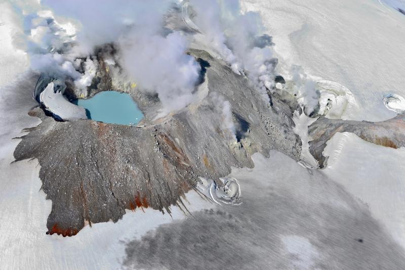
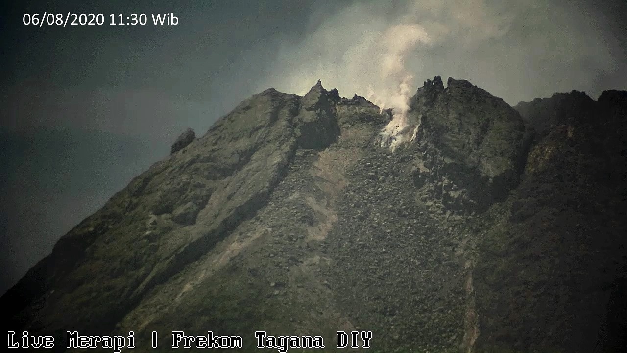
Indonesia , Merapi :
Mount Merapi Activity Report, August 21-27, 2020.
I. OBSERVATION RESULTS
Visual
The weather around Mount Merapi is generally sunny in the morning and at night, while the afternoon is foggy. There is a white smoke, medium to thick with low pressure. A maximum smoke height of 150 m is observed from the Babadan observation post on August 21, 2020 at 3:30 p.m. WIB.
Morphological analysis of the crater area based on photos of the south-eastern sector shows no change in the morphology of the dome. The volume of the lava dome based on measurements using aerial photos with drones on July 26, 2020 was 200,000 m3.
Seismicity
This week, the seismicity of Mount Merapi recorded
10 earthquakes of emissions (DG),
9 shallow volcanic earthquakes (VTB),
67 multiphase earthquakes (MP),
1 low frequency earthquake (LF),
42 avalanche earthquakes (RF),
19 tectonic earthquakes (TT).
The seismic intensity this week is relatively the same as last week.
Deformation
The deformation of Mount Merapi which was monitored using EDM this week showed a shortening of the distance of the beacons by approximately 1 cm.
Rain and lahars
This week there have been no reports of rain, lahars or additional flow in the rivers flowing down from Mount Merapi.
Conclusion
Based on the results of visual and instrumental observations, it is concluded that:
1. The lava dome is currently in stable condition.
2. The volcanic activity of Mount Merapi is still quite high and is at the “WASPADA” activity level.
Source : BPPTKG
Photo :Frekom .
Indonesia , Mud eruption in Blora :
Mud eruption in Blora poisons four residents, buries 19 buffaloes
A hot mud crater managed by the Randublatung forest management unit (KPH) at the Padas forest management resort (RPH) in Gabusan village, Central Java, erupted on Thursday morning. Gabusan village supervisory non-commissioned officer Chief Sgt. Jatmiko said four villagers were poisoned after inhaling gas from the eruption as they were herding buffaloes nearby. “Four residents, namely Marno, Sukimin, Kadis and Warino, were suspected of suffering from gas poisoning and were rushed to the nearest Puskesmas [community health center],” Jatmiko said on Thursday .
As many as 19 buffaloes belonging to residents were reportedly buried in the mud, he added. Gabusan village head Parsidi said the mud eruption occurred at around 5:30 a.m. with a deafening boom.
https://www.facebook.com/100048990452840/videos/175124004130614/
The Indonesian Association of Geologists’ East Java chairman, Handoko Teguh Wibowo, echoed Teguh’s statement, saying that the eruption was a mud volcano. “This shows the emergence of mud volcanoes. The mud has a composition of gases, water and solids,” said Handoko, who is also a geology and mining engineering lecturer at the Adhitama Institute of Technology in Surabaya, East Java. Unlike in a volcano that emits magma, the temperature of materials resulting from a mud volcano is lower. The materials released are fine grains suspended in a liquid. The gas produced is generally methane, with a small amount of carbon dioxide and nitrogen.
Source : thejakartapost.com