August 13 , 2020.
Indonesia , Sinabung :
VOLCANO OBSERVATORY NOTICE FOR AVIATION – VONA.
Issued : August 13 , 2020
Volcano : Sinabung (261080)
Current Aviation Colour Code : ORANGE
Previous Aviation Colour Code : orange
Source : Sinabung Volcano Observatory
Notice Number : 2020SIN06
Volcano Location : N 03 deg 10 min 12 sec E 98 deg 23 min 31 sec
Area : North Sumatra, Indonesia
Summit Elevation : 7872 FT (2460 M)
Volcanic Activity Summary :
Eruption with volcanic ash cloud at 08h02 LT (01h02 UTC)
Volcanic Cloud Height :
Best estimate of ash-cloud top is around 11072 FT (3460 M) above sea level, may be higher than what can be observed clearly. Source of height data: ground observer.
Other Volcanic Cloud Information :
Ash cloud moving to east-southeast-south
Remarks :
Seismic activity is characterized by volcanic tremor
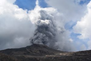
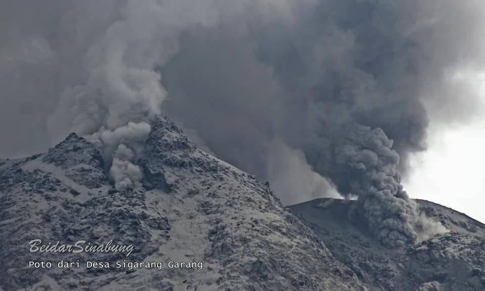
PVMBG reported that at 0158 on 8 August a phreatic eruption at Sinabung produced a brown-gray ash plume that rose 2 km above the summit and drifted E and SE. A news article stated that ashfall impacted at least four districts, including Naman Teran, Merdeka, Berastagi, and Dolat Rayat. BNPB noted that clean water was distributed, and emergency vehicles were deployed to clean up the ashfall. Later that day at 1718 an ash plume rose at least 1 km above the summit and drifted ESE. There is a general exclusion zone set at 3 km from the summit, with extensions to 5 km on the SE and 4 km on the NE. A news article noted that authorities began enforcing a 7-km exclusion zone.
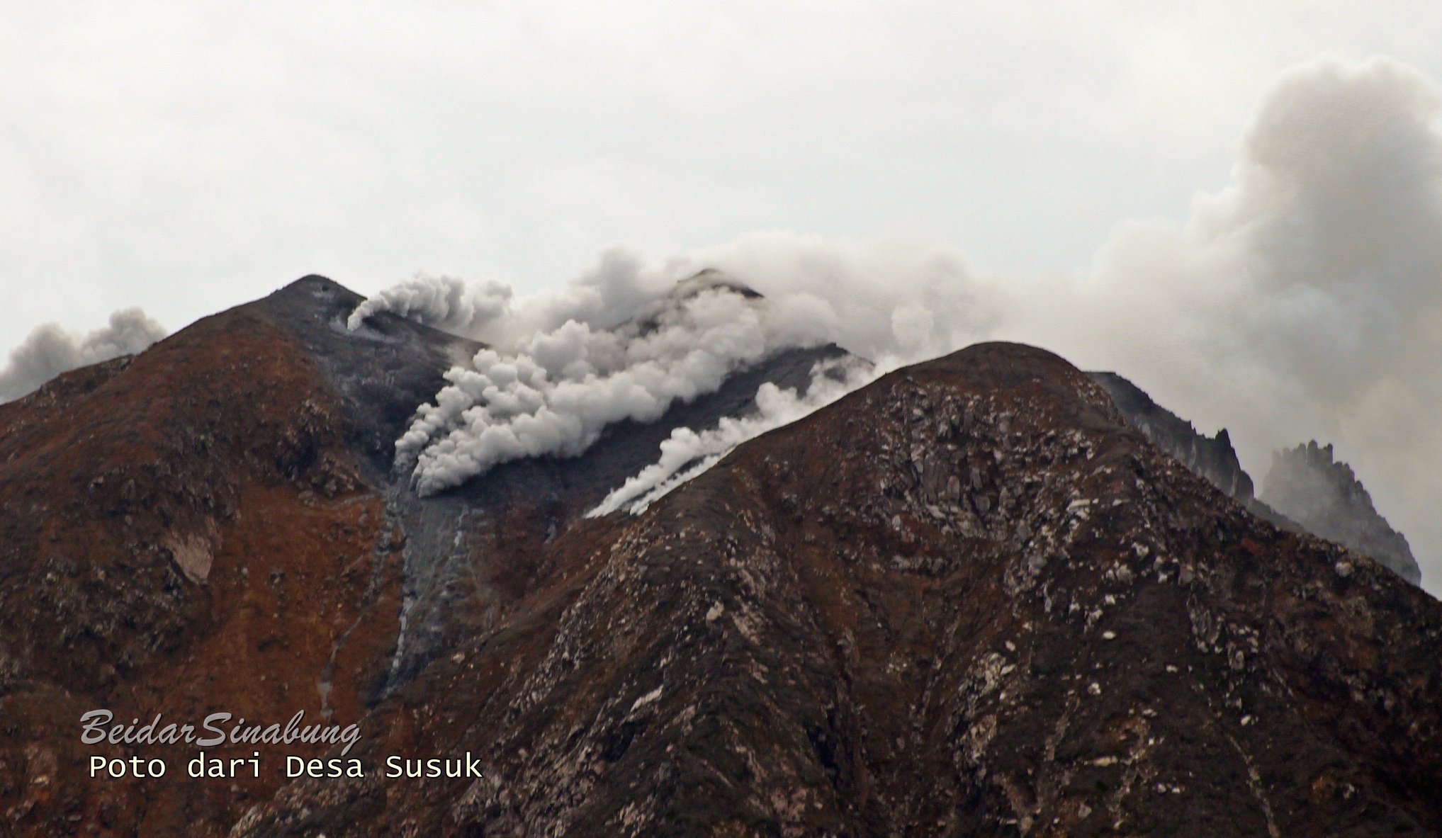
An eruptive event at 1016 on 10 August produced a dense gray ash plume that rose at least 5 km above the summit (24,500 ft a.s.l.) and drifted NE and SE. Parts of the plume drifted down the flank; ashfall was reported in several areas downwind. The Darwin VAAC advisory stated that satellite observations showed ash plumes drifting WNW at 9.8 km (32,000 ft) a.s.l. at 1430 and ENE at 4.3 km (14,000 ft) a.s.l. at 1630. The Alert Level remained at 3 (on a scale of 1-4). Residents and tourists in Berastagi (13 km E) turned on headlights to navigate through the ash according to a news article.
Source : Magma Indonésie , GVP.
Photo : Firdaus Surbakti/Beidar Sinabung.
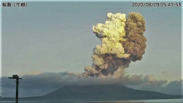
Japan , Sakurajima :
31,593 ° N, 130,657 ° E
Elevation : 1117 m
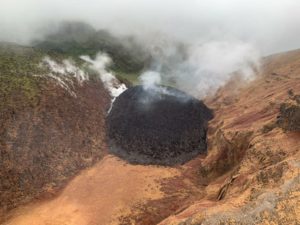
JMA reported that the daily sulfur dioxide emission rate at Minamidake Crater (at Aira Caldera’s Sakurajima volcano) was 700 tons/day on 3 August. An explosion at 0538 on 9 August produced an ash plume that rose as high as 5 km above the crater rim; ejected blocks were not visually confirmed due to weather conditions. Ashfall was reported in areas N of the crater including Kagoshima City (about 10 km W), Kirishima City (20 km NE), Yusui Town (40 km N), and parts of the Miyazaki Prefecture and the Kumamoto Prefecture. After the explosion at 0538, smaller eruptions were intermittently detected through 10 August. The Alert Level remained at 3 (on a 5-level scale).
The Aira caldera in the northern half of Kagoshima Bay contains the post-caldera Sakurajima volcano, one of Japan’s most active. Eruption of the voluminous Ito pyroclastic flow accompanied formation of the 17 x 23 km caldera about 22,000 years ago. The smaller Wakamiko caldera was formed during the early Holocene in the NE corner of the Aira caldera, along with several post-caldera cones. The construction of Sakurajima began about 13,000 years ago on the southern rim of Aira caldera and built an island that was finally joined to the Osumi Peninsula during the major explosive and effusive eruption of 1914. Activity at the Kitadake summit cone ended about 4850 years ago, after which eruptions took place at Minamidake. Frequent historical eruptions, recorded since the 8th century, have deposited ash on Kagoshima, one of Kyushu’s largest cities, located across Kagoshima Bay only 8 km from the summit. The largest historical eruption took place during 1471-76.
Source: : Japan Meteorological Agency (JMA) , GVP.
Photo : Setiawan.
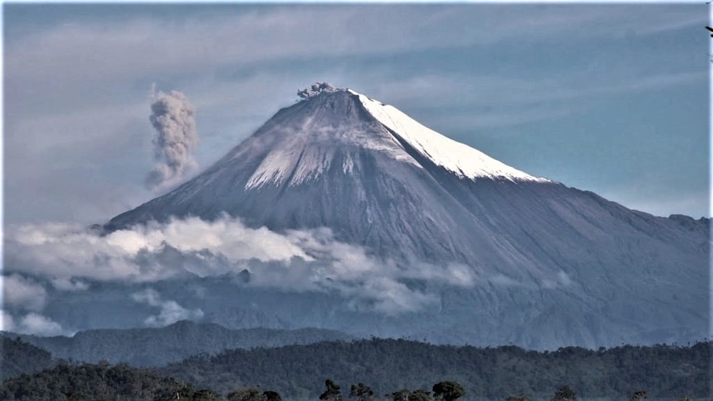
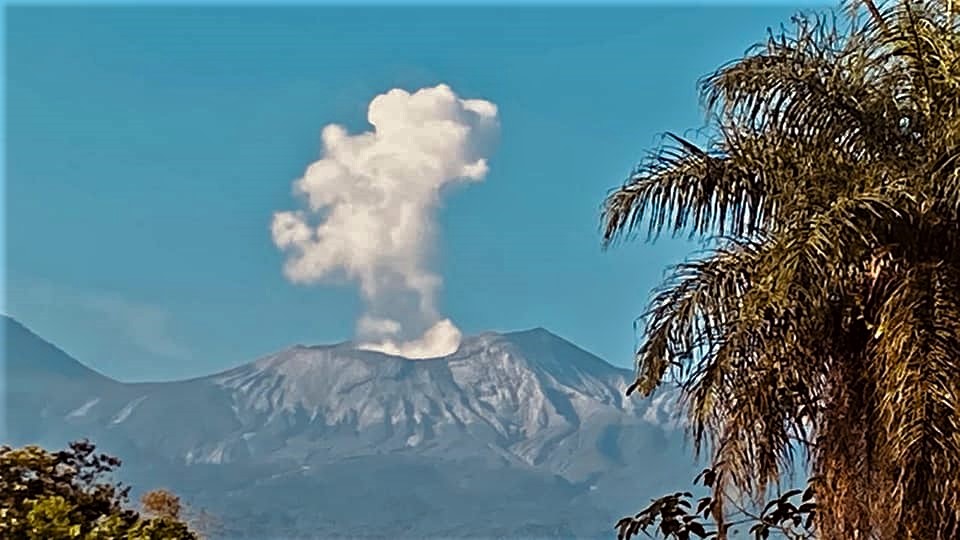
Ecuador , Sangay :
2.005°S, 78.341°W
Elevation 5286 m
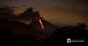
IG reported a high level of activity at Sangay during 5-11 August. Weather clouds often prevented visual observations of the volcano; according to Washington VAAC notices and IG webcams ash plumes rose 870-2,000 m above the summit and drifted NW, W, and S almost daily. Heavy rain generated secondary lahars in the Volcán and Upano drainages during 5-7 August.
DAILY REPORT ON THE STATE OF THE SANGAY VOLCANO, Wednesday August 12, 2020.
Surface activity level: High, Surface trend: No change.
Internal activity level: High, Internal trend: Increasing.
Seismicity: From August 11, 2020, 11:00 a.m. to August 12, 2020, 11:00 a.m .:
Long period type events: 26
Explosions: 168
Emission tremor: 2
Harmonic tremor: 1
Rains / lahars: There were several episodes of rains in the area which generated signals associated with mudslides and debris.
* In case of heavy rains, lahars can be generated in the Volcán, Upano and other tributaries. *
Emission / ash column: No emission was observed through the cameras. In satellite images provided by the Washington VAAC, 5 ash emission alerts were recorded in the direction of the South and West.
The heights reached 900 and 1200 meters above the level of the crater.
Other monitoring parameters: No changes.
Observations: In general, during the past 24 hours, cloudiness in the area was permanent, preventing detailed observations of surface level activity.
Alert level: yellow.
Source : IGEPN , GVP.
Photo : IGEPN.
Costa Rica , Turrialba / Poas / Rincon de la Vieja :
Turrialba volcano
Lat: 10.025 ° N; Long: 83.767 ° W;
Height: 3340 m.s.n.m.
Current activity level: 3 (erupting volcano)
Potentially associated hazards: gas, ash emission, proximal ballistic projections.
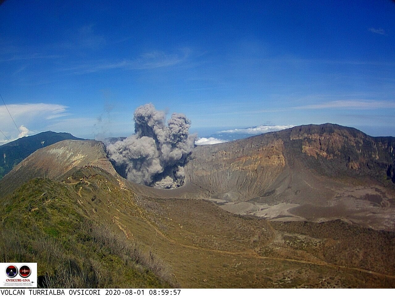
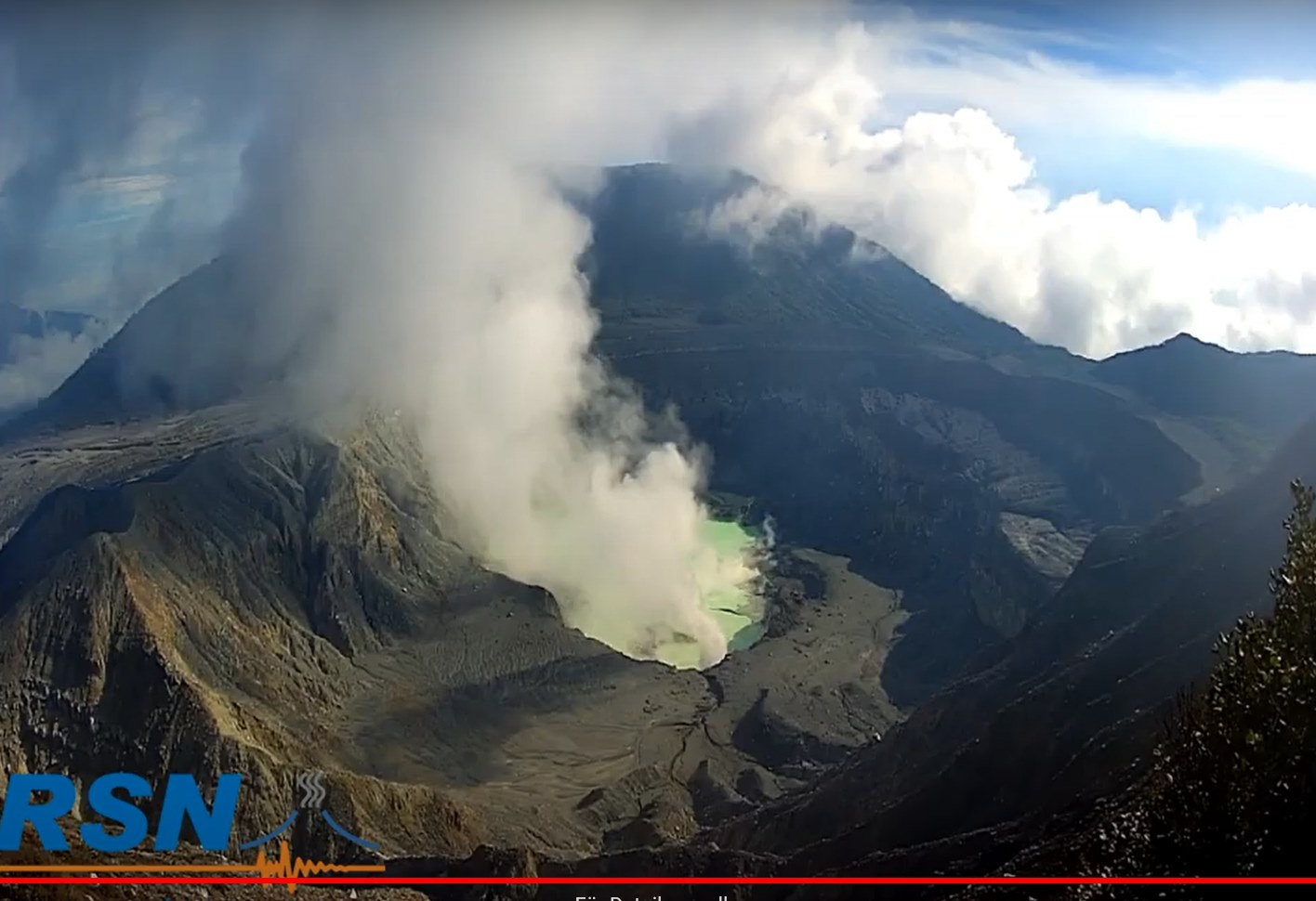
Less diluted ash emissions were observed. The seismic activity shows a decrease with some LP type events and tremors. The contraction and subsidence of the Turrialba-Irazú massif continues. The CO2 / SO2 and H2S / SO2 ratios are stable with some sporadic peaks. The flow of SO2 remains stable. No thermal anomaly was detected by the MODIS analysis.
Poas volcano:
Lat: 10.2 ° N; Long: 84.233 ° W;
Height: 2780 m.s.n.m.
Current activity level: 2 (active volcano)
Potentially associated hazards: gas, phreatic eruptions, proximal ballistic projections
No eruption was detected. Seismic activity has continued to decline since May. The number of LP-type events decreased as well as the amplitude of these events. There is no significant deformation. The SO2 / CO2 and H2S / SO2 ratios show a decrease, as does the maximum SO2 concentration. The flow of SO2 remains stable with a slight downward trend since June. The lake level has stabilized, as has the estimate of evaporation. The SO2 concentration at the national park level has sporadically reached 6 ppm over the past week.
Rincon de la Vieja volcano
Lat: 10.83 ° N; Long: 85.324 ° W;
Height: 1895 m.s.n.m.
Current activity level: 3 (erupting volcano)
Potentially associated hazards: gas, phreatic eruptions, proximal ballistic projections, lahars.
A few small phreatic eruptions were recorded. The seismic activity is still unstable: the RSAM is very variable, without clear trend. No VT or « tornillos » type event was recorded, but the number of LP type events increased as well as the associated amplitude. There is no diagram of tremors.
The trend towards inflation and expansion observed by GPS stations is less marked. The redox potential measured at a hot source has stabilized. No thermal anomaly was detected by the MODIS analysis.
Source : Ovsicori .
Photos : Ovsicori , Rsn , Maurice Gutiérrez