August 28 , 2020.
Costa Rica , Irazu :
No eruption is reported.
Seismic activity is higher compared to yesterday.
At the time of this report, the winds are blowing south.
https://www.facebook.com/OVSICORI/posts/3134183356618901
The CO2 concentration in the North zone has returned to normal values. The number of landslides recorded by the seismic network showed an exponential increase, especially since August 20 (> 30 events identified on August 23). The acceleration of the main glide is still very strong, with speed increasing by 30% every week. On August 24, the movement speed reached> 20 m / year (horizontal) and ~ 25 m / year (vertical). A movement of more than 20 centimeters is recorded in the last 24 hours. According to photogrammetric measurements, the breaking of the area into blocks has been identified, some moving more than 3 times faster than the reference GPS. Some blocks have a southern movement component.
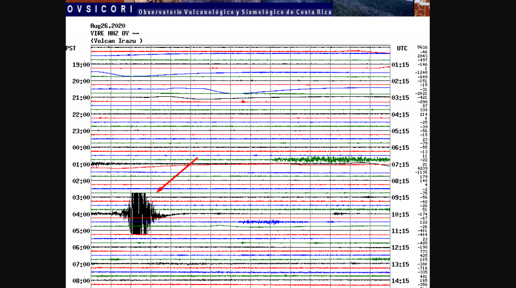
Seismographs from almost all of the country as well as infrasound sensors from the volcanoes Irazú, Turrialba, Poás and Rincón de la Vieja detected today, August 26, 2020 around 4:00 a.m., signals due to the collapse of a block important in the high outer wall of the western sector of the Irazú volcano, precisely where there are several of the telecommunications towers that are at the top of the Irazú volcano. At least one of the towers (that of channel 23) is partially suspended in the air and is in imminent danger of falling into the canyon of the Sucio river basin.
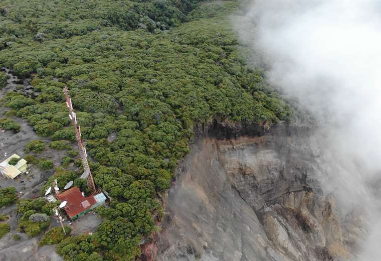
Staff and residents of Irazú Volcano National Park said they felt ground movement and heard the sound of the collapsed block falling. At the moment, volcanologists from OVSICORI-UNA are in the affected area to document the situation, the damage and the possible consequences using drones. The movement of the block that collapsed today, August 26, 2020, has been detected since 2011 thanks to the GPS network and the OVSICORI-UNA seismographs located on the Irazú and Turrialba volcanoes.
In 2014, several major collapses were detected on the seismographs and infrasound sensors of the OVSICORI-UNA. In 2015, a significant widening of the cracks and an increase in the irregularity of the said block were observed, indicating landslides in the vertical and horizontal planes. In the same year, MINAE issued a recommendation to relocate several of the telecommunication antennas located at the top of the Irazú and near the edge of the landslide (landslide crown) from their sites due to the potential danger of landslide. fast from the block.
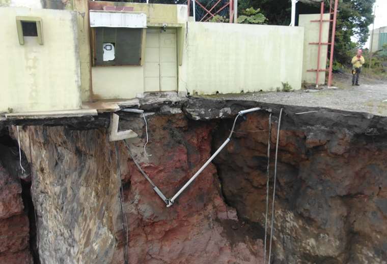
During the year 2020, the OVSICORI-UNA recorded an acceleration of the movement of the block which collapsed today, using GPS systems, seismographs and infrasound sensors, and informed the CNE and the staff of the Volcán Irazú National Park on the acceleration of this movement and on the possible collapse to be expected between August and October 2020 in the event of heavy rains and if the level of acceleration of the terrain is maintained.
Source : Ovsicori .
Photos : Teletica.
Ecuador : Sangay :
Information VOLCÁN SANGAY N ° 094, THURSDAY AUGUST 27, 2020
This August 27, thanks to the images of the ECU911, we can observe the strong activity of the Sangay volcano, with emission of ash and pyroclastic flows in the Southeast ravine. The wind carries the ashes towards the southwest, which could generate moderate ash fall in the province of Chimborazo. This phenomenon has been persistent during the current eruptive period which began in May 2019. It is recommended to take the appropriate measures and receive the information from official sources.
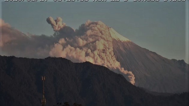
In the morning, on images shared by ECU911, the volcano was observed cloudy. The VAAC recorded 2 ash emission alerts, the direction varied from southwest to west, these emissions reached heights of up to 600 meters above the crater level.
For the past 24 hours, the volcano was from partly cloudy to cloudy, preventing observations of surface activity.
Until the close of this bulletin, there are no reports of possible ash fall. Due to transmission problems at the reference station, seismic data is not available for today.
The Geophysical Institute of the National Polytechnic School is keeping an eye on the activity of the volcano and will report on any changes that may be recorded.
Source : IGEPN.
Kamchatka , Sheveluch :
56.64 N, 161.32 E;
Elevation 10768 ft (3283 m), the dome elevation ~8200 ft (2500 m)
Aviation Colour Code is ORANGE
The extrusive eruption of the volcano continues. Ash explosions up to 32,800-49,200 ft (10-15 km) a.s.l. could occur at any time. Ongoing activity could affect international and low-flying aircraft.
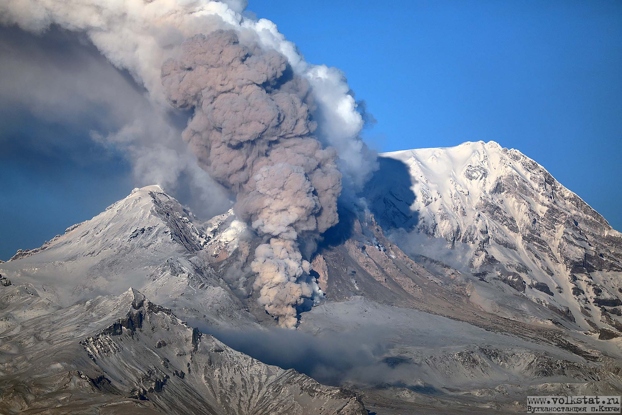
A growth of the lava dome continues, a strong fumarolic activity sometimes with some amount of ash, and an incandescence of the western part of the lava dome and hot avalanches accompanie this process. Satellite data showed a thermal anomaly over the volcano all week, excluding 27 August when the volcano was obscured by clouds; the plume of an resuspended ash extended for 75 km to the east-southeast of the volcano on 24 August.
Source : Kvert .
Photo : Archive Volkstat ru
Italy , Campi Flegrei :
Weekly bulletin from August 17, 2020 to August 23, 2020, (issue date August 25, 2020)
SUMMARY OF THE STATE OF ACTIVITY
In the light of the surveillance data, it is highlighted:
1) SEISMOLOGY: In the week of August 17 to 23, 2020 in the Campi Flegrei region, 3 low energy earthquakes (Mdmax = -0.5) were recorded.
2) DEFORMATIONS: The average value of the lifting speed in the maximum deformation zone, from January 2020, is approximately 6 mm / month. The ascent recorded at the RITE GPS station has been approximately 63.5 cm since January 2011.
3) GEOCHEMISTRY: The soil CO2 fluxes measured during the period studied did not show any significant changes after the drop in values recorded in early May, probably
linked to local variations of the transmission site measured by the station. The temperature of the main fumarole of Pisciarelli showed an average value of about 115 ° C.
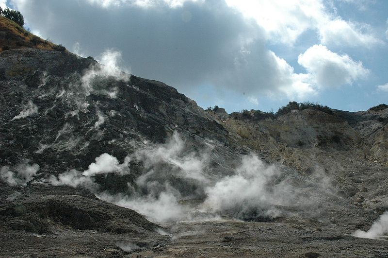
GEOCHEMISTRY
The values of the CO2 flux from the soil continuously recorded by the FLXOV8 station in the Pisciarelli area (north-eastern outer slope of the Solfatara), highlight the persistence of multi-year trends already identified previously (see monthly reports). Soil CO2 fluxes measured last week did not show any significant changes after the drop in values recorded in early May, probably linked to local variations in the emission site measured by the station.
In the period from August 10 to 16, 2020, the temperature of the main fumarole of Pisciarelli recorded continuously showed an average value of ~ 115 ° C, in line with the values recorded in previous periods.
It should be noted that this fumarole being a constantly evolving natural system, with macroscopic variations of the emission site, the temperature recorded continuously may not always coincide with the maximum emission temperature.
Source : INGV .
Read the article : http://www.ov.ingv.it/ov/bollettini-campi-flegrei/Bollettino_Flegrei_2020_08_25.pdf
Photo : Manuel Mauer / Wikipédia