April 10 , 2024.
Italy , Stromboli :
WEEKLY BULLETIN, from April 1, 2024 to April 7, 2024. (issue date April 9, 2024)
SUMMARY STATEMENT OF ACTIVITY
In light of the monitoring data, it appears:
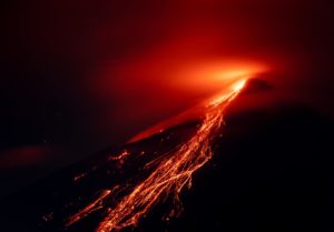
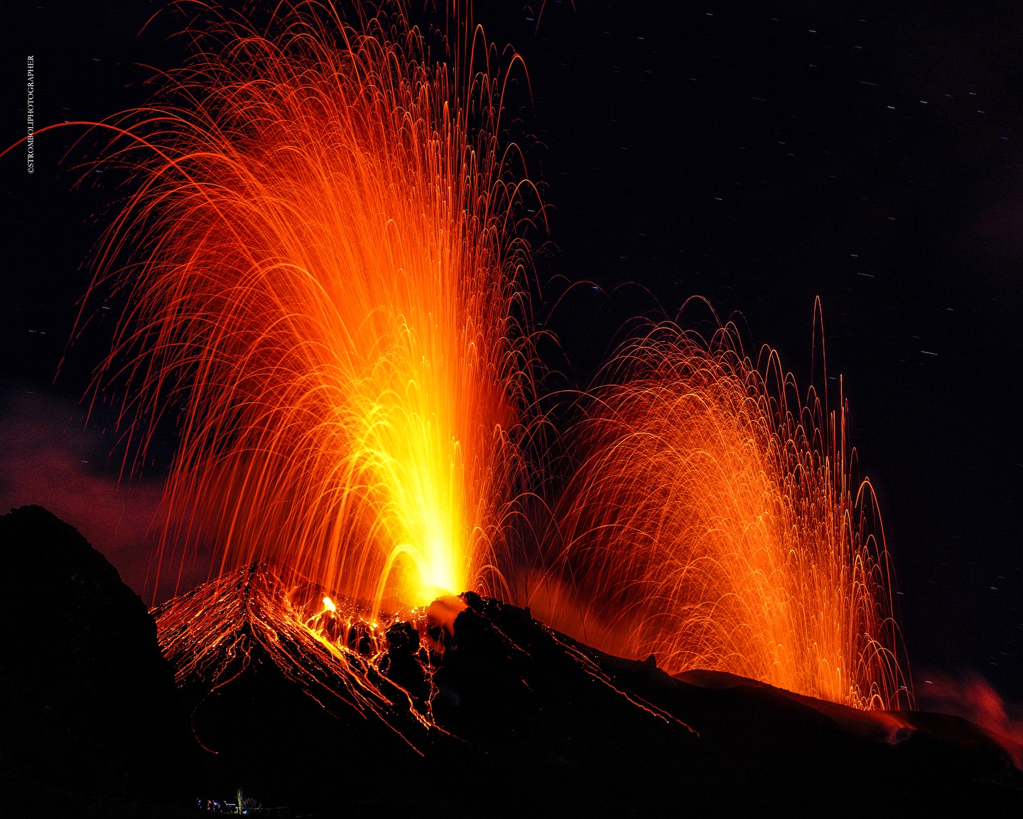
1) VOLCANOLOGICAL OBSERVATIONS: Normal Strombolian activity was observed during this period. The total hourly frequency fluctuated between medium values (7 events/h) and high values (16 events/h). The intensity of the explosions was low in the areas of the North and South Central craters.
2) SISMOLOGY: The monitored seismological parameters do not show significant variations.
3) GROUND DEFORMATIONS: Ground deformation monitoring networks do not show significant variations.
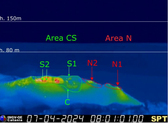
The crater terrace seen from the thermal camera located on the Pizzo sopra la Fossa with the delimitation of the crater zones: South-Central Zone and North Zone (respectively ZONE N, ZONE C-S). The acronyms and arrows indicate the names and locations of the active vents, the area above the crater terrace is divided into three height intervals relating to the intensity of the explosions.
4) GEOCHEMISTRY: SO2 flux at medium level
The CO2 flux in the summit zone is high.
C/S ratio in the plume: there are no updates.
Helium Isotope Ratio in Thermal Aquifer: There are no updates.
CO2 flux in Scari: stable values at average levels.
5) SATELLITE OBSERVATIONS: Thermal activity observed by satellite was generally low level with some rare and isolated thermal anomalies of moderate level.
VOLCANOLOGICAL OBSERVATIONS
In the observed period, the eruptive activity of Stromboli was characterized through the analysis of images recorded by the INGV-OE surveillance cameras located at Pizzo (SPT), at altitude 190m (SCT-SCV) and at Punta dei Corvi (SPCT) and an inspection carried out by INGV-OE staff on April 7, 2024. The explosive activity was mainly produced by 2 (two) eruptive vents located in the North Crater area and by 2 (two ) vents located in the South Central zone.
Observations of explosive activity captured by surveillance cameras
In correspondence with the area of the North crater (N), characterized by a mouth located in sector N1 and a mouth located in sector N2, constant explosive activity was observed in sector N1 and sporadic in sector N2; in both sectors, the intensity was low (less than 80 m in height). The products emitted in the eruption were mainly coarse materials (bombs and lapilli). The average frequency of explosions fluctuated between 3 and 7 events/h.
In the South-Central (CS) zone, sectors C and S1 did not show significant activity. In sector S2, characterized by two emission points, the explosions were mainly of low intensity (less than 80 m in height) and sometimes medium (less than 150 m in height), with emission of fine material sometimes mixed with coarse materials. . The average frequency of explosions varied between 5 and 10 events/h.
Source : INGV
Photos : INGV , Stromboli stati d’animo / Sebastiano Cannavo.
Aleutian Islands , Atka :
AVO/USGS Volcanic Activity Notice
Current Volcano Alert Level: NORMAL
Previous Volcano Alert Level: ADVISORY
Current Aviation Color Code: GREEN
Previous Aviation Color Code: YELLOW
Issued: Tuesday, April 9, 2024, 7:34 AM AKDT
Source: Alaska Volcano Observatory
Notice Number: 2024/A325
Location: N 52 deg 19 min W 174 deg 8 min
Elevation: 5030 ft (1533 m)
Area: Aleutians
Volcanic Activity Summary:
Volcanic activity at the Atka volcanic complex has decreased since a small explosion was detected from the summit crater of Korovin, one of several volcanoes there, on March 27 (AKDT). Although occasional small earthquakes and weak volcanic tremor continue to be observed, the current activity is at background levels. Due to this decrease in activity, the Alaska Volcano Observatory is lowering the Aviation Color Code and Volcano Alert Level to GREEN/NORMAL.
Remarks:
The Atka volcanic complex forms the northern part of Atka Island, located about 16 km north of the community of Atka and 1,761 km southwest of Anchorage. The Atka volcanic complex includes a possible older caldera and several younger vents, including Korovin Volcano, Mount Kliuchef, and Sarichef Volcano. Korovin Volcano, a 1553-m-high (5030 ft) stratovolcano, has been the site of most historical volcanic activity, and has a small, roiling crater lake that occasionally produces energetic steam emissions. Korovin has erupted several times in the past 200 years, including 1973, 1987, and 1998, and has likely had small ash emissions as recently as 2005. Typical recent Korovin eruptions produce minor amounts of ash and occasional but small lava flows. Reports of the height of the ash plume produced by the 1998 eruption ranged as high as 10,600 m (35,000 feet) above sea level. Mount Kliuchef is composed of a series of five vents aligned northeast–southwest. The two main summit vents of Kliuchef appear relatively young and the easternmost was probably the source of an 1812 eruption that is sometimes attributed to Sarichef.
Source : AVO
Photo : Schaefer, Janet / avec l’aimable autorisation de l’AVO/ADGGS.
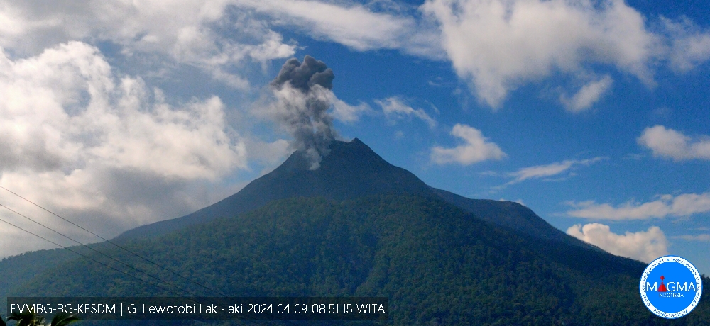
Indonesia , Lewotobi Laki Laki :
An eruption of Mount Lewotobi Laki occurred on Tuesday, April 9, 2024 at 08:48 WITA with the height of the ash column observed at ±700 m above the summit (±2284 m above sea level). The ash column was white to gray in color with moderate to thick intensity, oriented towards the North and Northeast. At the time of writing, the eruption was still ongoing.
Observation of seismicity:
2 eruption earthquakes with an amplitude of 7.4 mm and a seismic duration of 60 to 64 seconds.
3 emission earthquakes with an amplitude of 2.2 to 2.9 mm and duration of the earthquake from 29 to 107 seconds.
4 harmonic tremors with an amplitude of 2.2 to 2.9 mm and an earthquake duration of 66 to 204 seconds.
1 Low frequency earthquake with an amplitude of 7.4 mm and an earthquake duration of 52 seconds.
1 hybrid/multiphase earthquake with an amplitude of 2.9 mm, and an earthquake duration of 22 seconds.
1 Deep volcanic earthquake with an amplitude of 22 mm, duration of the earthquake 10 seconds.
2 local tectonic earthquakes with an amplitude of 3.7 to 14.8 mm, and an earthquake duration of 21 to 25 seconds.
7 distant tectonic earthquakes with an amplitude of 2.2 to 17 mm, and an earthquake duration of 43 to 315 seconds.
RECOMMENDATION
1. Communities around Mount Lewotobi Men and visitors/tourists do not carry out any activities within a radius of 2 km around the center of the eruption of Mount Lewotobi laki and in the sector of 3 km in the North-North direction. East and 5 km in the North East direction.
2. The public should remain calm and follow the instructions of the regional government and not believe rumors whose origin is unclear.
3. Communities around Mount Lewotobi Laki are wary of the risk of lahar flooding in the rivers that originate at the top of Mount Lewotobi Laki during heavy rains.
Source et photo : Magma Indonésie
Colombia , Cerro Machin :
Weekly Activity Bulletin: Cerro Machín Volcano
Regarding the monitoring of the activity of the CERRO MACHÍN VOLCANO, the MINISTRY OF MINES AND ENERGY, through the COLOMBIAN GEOLOGICAL SERVICE (SGC), reports that:
For the week of April 2 to 8, 2024, the recording of seismicity associated with the fracturing of rocks inside the volcanic edifice continued. Compared to the previous week, this seismic activity maintained similar levels in the number of earthquakes recorded and decreased in the seismic energy released. The earthquakes were located in the southern and eastern sectors of the central zone of the volcanic edifice and on its southwest flank, at distances less than 2 km from the main dome. The earthquakes were of low energy (magnitudes less than 1) and their depths varied between 2 and 5 km.
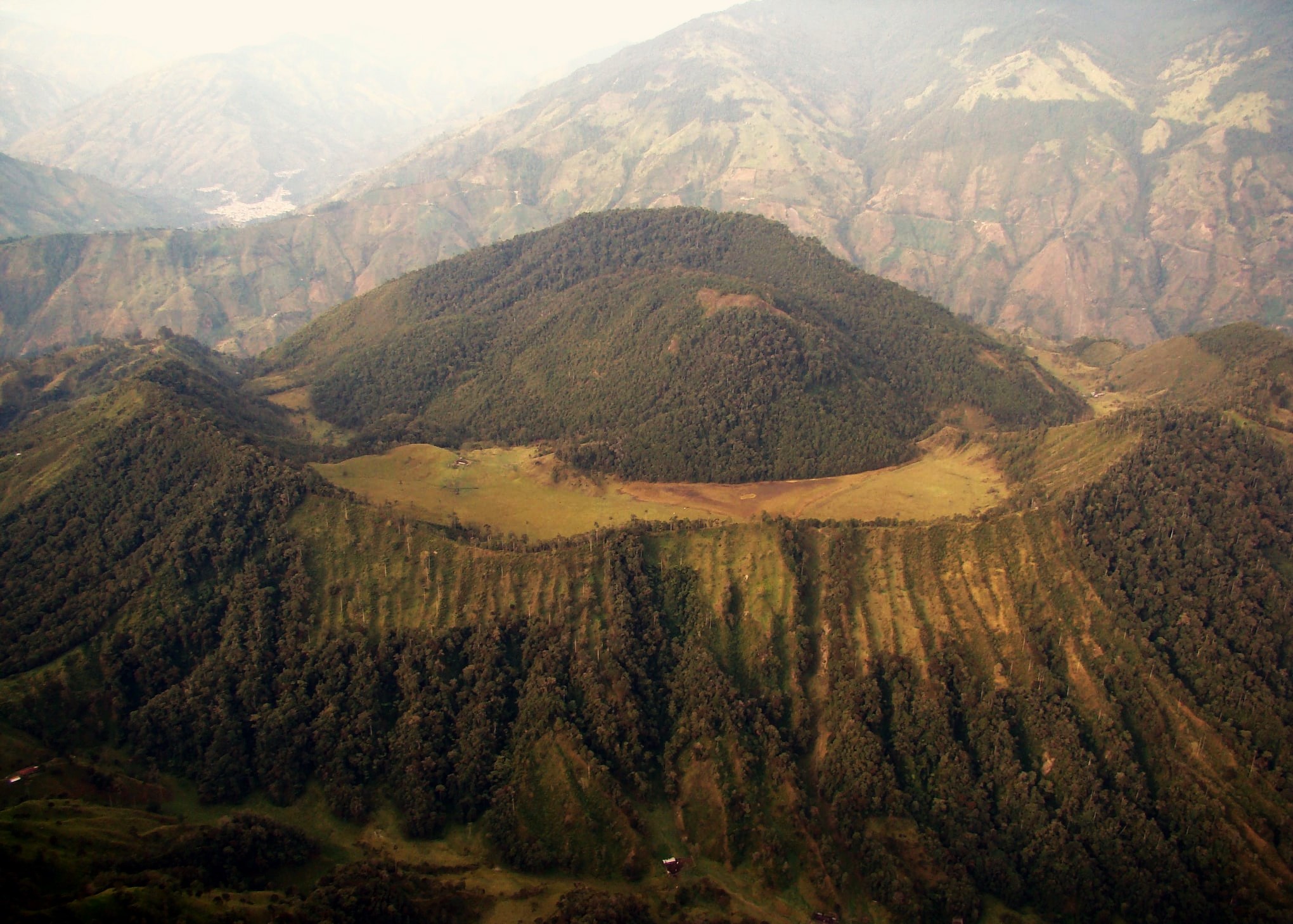
From the SGC we want to emphasize that after the increase in seismicity recorded on March 23, the volcano is in a state of low instability and, therefore, currently its probability of eruption continues to be low. This is demonstrated by the seismicity with low energy levels and by the stability it demonstrated in the other monitored parameters. The SGC carries out permanent monitoring of the volcano’s activity in real time, which allows us to detect changes and inform the corresponding authorities and communities in a timely manner, as we have done so far. We invite the community to always consult the official information offered by the SGC on the activity of this volcano that we have been monitoring since 1989.
The alert status for volcanic activity remains at: YELLOW ALERT: ACTIVE VOLCANO WITH CHANGES IN THE BEHAVIOR OF THE BASE LEVEL OF MONITORED PARAMETERS AND OTHER MANIFESTATIONS.
Source et photo : SGC
Hawaii , Kilauea :
Tuesday, April 9, 2024, 8:46 AM HST (Tuesday, April 9, 2024, 18:46 UTC)
19°25’16 » N 155°17’13 » W,
Summit Elevation 4091 ft (1247 m)
Current Volcano Alert Level: ADVISORY
Current Aviation Color Code: YELLOW
Activity Summary:
Kīlauea volcano is not erupting. Low-level seismicity continues beneath the summit and Southwest Rift Zone, while rates of ground deformation remain low.
Summit Observations:
Low levels of seismicity continue beneath Kīlauea’s summit. During the past week, the rate of earthquakes here were slightly elevated, but daily earthquake counts remain well below those detected during the January–February intrusion or prior to recent summit eruptions. At this time, earthquake depths beneath the summit are primarily 0.3–1.6 miles (0.5–2.5 kilometers) below the surface, and magnitudes are typically below M2.0.
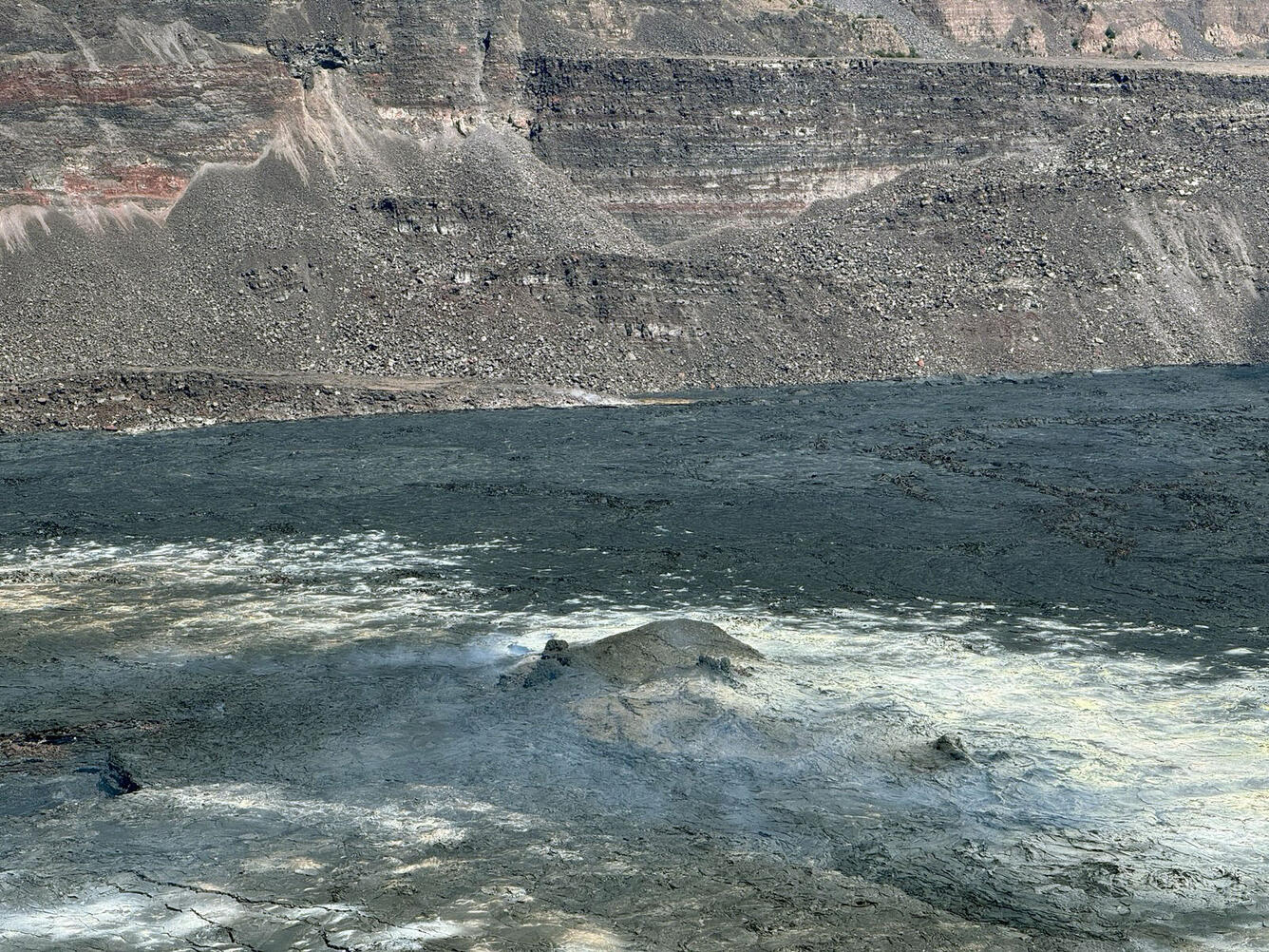
A close-up of the central portion of the floor of Halema‘uma‘u, at the summit of Kīlauea. The small mound is the remaining portion of the island (or raft) of material formed in the early stages of the first crater-filling eruption in December 2020.
Ground deformation continues at low rates across Kīlauea, with tiltmeters near Uēkahuna and Sand Hill—respectively northwest and southwest of the summit caldera—showing only small changes over the past week.
Sulfur dioxide (SO2) gas emissions have remained at low, noneruptive levels since October 2023. An SO2 emission rate of approximately 60 tonnes per day was recorded on March 27.
Rift Zone Observations:
Low levels of seismicity continue beneath Kīlauea’s Southwest Rift Zone. During the past week, daily earthquake counts remained well below those detected during the January–February intrusion. No unusual activity has been noted along the East Rift Zone. We continue to closely monitor both rift zones.
Measurements from continuous gas monitoring stations downwind of Puʻuʻōʻō in the middle East Rift Zone—the site of 1983–2018 eruptive activity—remain below detection limits for SO2, indicating that SO2 emissions Puʻuʻōʻō are negligible.
Source : HVO
Photo : USGS/ M. Patrick