October 09 , 2018.
La Réunion , Piton de la Fournaise :
Activity Bulletin from Monday, October 8, 2018 at 16:00 (local time).
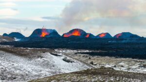
The eruption started on September 15th at 4:25 am local time continues. The intensity of the volcanic tremor (indicator of the eruptive intensity at the surface), after having increased markedly since October 3 at 22h local time (18h UTC) – due to a gradual closure of the entire feeding system, going from the dike (« feeding duct » of the eruption) to the eruptive cone, favoring a phenomenon of « resonance » more important) – has been gradually decreasing for three days (Figure 1).
Piston gases (« gas flushes » or « tremor puffs ») at the eruptive site are always recorded by the OVPF seismometers.

Figure 1: Evolution of RSAM (indicator of volcanic tremor and intensity of eruption) between 04:00 (00h UTC) September 15 and 16:00 (12:00 UTC) October 8 on FOR seismic station, located near the crater Chateau Fort (2000 m altitude on the southeast flank of the terminal cone). (© OVPF / IPGP)
– No volcano-tectonic earthquake was recorded during the day of 7 October or during the current day.
– An inflation (swelling) of the building, witnessing the influence of a source of pressure at the foot of the volcano, is still perceptible. This inflation is accompanied by an increase in the concentrations of CO2 in the soil in the area of the Volcano Cottage.
– The OVPF NOVAC network stations located around the Enclos still record SO2 flows. Even though their concentrations are 5 times lower than at the beginning of eruption, these flows confirm that there is still magma present at low pressure.
– Observations made today from the Piton de Bert and from the air by OVPF teams have made it possible to locate the flow front. Since September 30, the northern front has progressed 1.8 km and was this morning (8:00 am local time) 500m of the great slopes, the southern and central fronts have not moved. The north front was this morning less than 120 m from the southern wall of Enclos Fouqué. Detailed mapping was also possible by the OI2 service (Clermont Auvergne University, Figure 2).
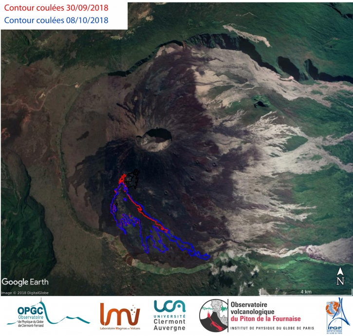
Figure 2: Contour mapping of the lava flows between 30/09/2018 (in red) and 08/10/2018 (in blue) deduced from InSAR coherence images. (© LMV / OPGC-OVPF / IPGP)
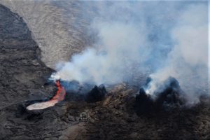
The surface activity at the level of the eruptive vent is always very limited.
No projection was visible between 10 and 12:30 (local time) but only emissions of gas and steam, sometimes accompanied by detonations. A lava lake is always present inside the cone (Figure 3).
Nevertheless, the activity continues in lava tunnels, with degassing particularly visible along their path, from the eruptive vent to the casting front (Figures 3 and 4). This morning (between 10am and 12:30 local time), a resurgence fed an active channel on all the last third of the northern branch thus favoring its progression towards the East.
– The surface flow rates could not be estimated today because of lava flows that are too weak at the surface.
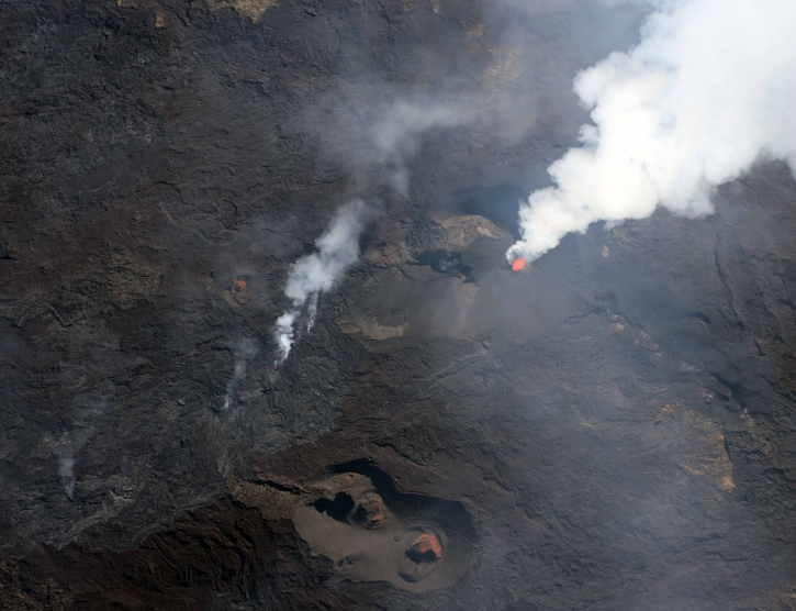
Figure 3: Shooting of the eruptive site on 08/10/2018 around 08h00 local time. (© OVPF / IPGP)
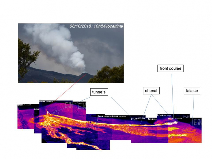
Figure 4: Thermal imaging of the eruptive site and the lava field taken from Piton Bert on 08/10/2018 around 10h50 local time. (© OVPF / IPGP)
Balance sheet:
Since October 3rd, the OVPF has been recording signals of two trends occurring at different levels:
1) at the level of the eruptive vent: records of « piston gas »; and weak surface activity, most of the activity taking place in lava tunnels with a resurgence this morning feeding an active channel on the last third of the north face of the flow;
2) at the level of the superficial reservoir: pressurization of a localized source under the summit craters at a depth of 1-1.5 km (detected by the inflation of the building) witnessing a refilling of the superficial reservoir by deeper magma (increased CO2 concentrations in the soil outside the Enclos).
Given these two observables, no assumption is excluded as to the continuation of this eruption in the coming days (shutdown, re-intensification of activity on the same site, opening of new cracks, especially further downstream).
Source : OVPF , www.ipgp.fr/fr/ovpf/bulletin-dactivite-lundi-8-octobre-2018-a-16h00-heure-locale
Andaman and Nicobar , Barren Island :
India’s Only Active Volcano Erupts Again, Experts Link It To Indonesian Earthquake
India’s only active volcano Barren Island has begun spewing lava and ash again, Times of India has reported. Geologists believe that fresh volcanic activity is linked to the recent earthquake in Indonesia.
On 25 September, Indonesian Island of Sulawesi was hit by an earthquake of magnitude 7.5. According to officials of Geological Survey of India (GSI), the volcanic eruption was first detected on 25 September.
“There have been many cases of volcanic eruptions which were preceded by earthquakes of mild intensity. They could be linked, and the source of the trigger may be the same, as the location of Sulawesi earthquake is not very far away,” Director PSS, GSI (North East), Tapan Pal told Times of India. Further, he added that the two events could also be two separate events.
The entire region tectonically active as the Indian plate is sub-ducting below the Burma plate and Indonesian Plate is sub-ducting below the Australian plate. Oceanic crusts melt and comes to the surface as a volcano due to subduction. The previous volcano recorded near Barren Island was during February 2016.
“The volcanic eruption was first evidenced on September 25 and the satellite images confirmed the spewing of lava or pyroclastic material and ash on the north flank of the island,” TOI reported, quoting the Geological Survey of India (GSI) officials as saying.
“Although, there have been many instances of volcanic eruptions which were preceded by mild intensity earthquakes. The GSI, say that it is just be a coincidence and the two may be separate and simultaneous events and the source may be different. “Only a detailed study will ascertain the cause of the eruption,” Tapan Pal, director, PSS, GSI, northeast region said.
The Indian National Centre for Ocean Information Services (INCOIS), Hyderabad, a government agency that monitors earthquakes and releases bulletins, have recorded magnitude between 4.3 and 4.9 in the Indonesian region of Southeast Asia in the days preceding the volcanic eruption from the Barren Island.
“The entire zone is tectonically quite active. As a matter of fact, Indian plate is subducting below Burma plate and the Indonesian plate is subducting under the Australian plate. The oceanic crust melt and migrates upwards until it erupts when the subduction is continuous,” Pal further explained, as for a possible cause of the eruption recorded in September end.
The last recorded volcanic eruption on Barren Island was in February 2016. The GSI official said the 2005 eruption occurred almost a year after the 2004 tsunami that was triggered by an earthquake in Indonesia.
As per an Indian Space Research Organsiation (ISRO) study, scientists have concluded the volcanic spewing that occurred in 2017 was a continuation of the eruption that took place in 2005. Scientists used satellite data to understand the changes in the volcanic region in terms of shape, area and path of lava flows between the years 2005 and 2017.
Source : swarajyamag.com, The Financial Express.
Photos : Vinay Dixit via Sherine France.
Costa Rica : Poas :
Irregular activity resulted in the closure of Poás Park, visitors were temporarily evacuated.
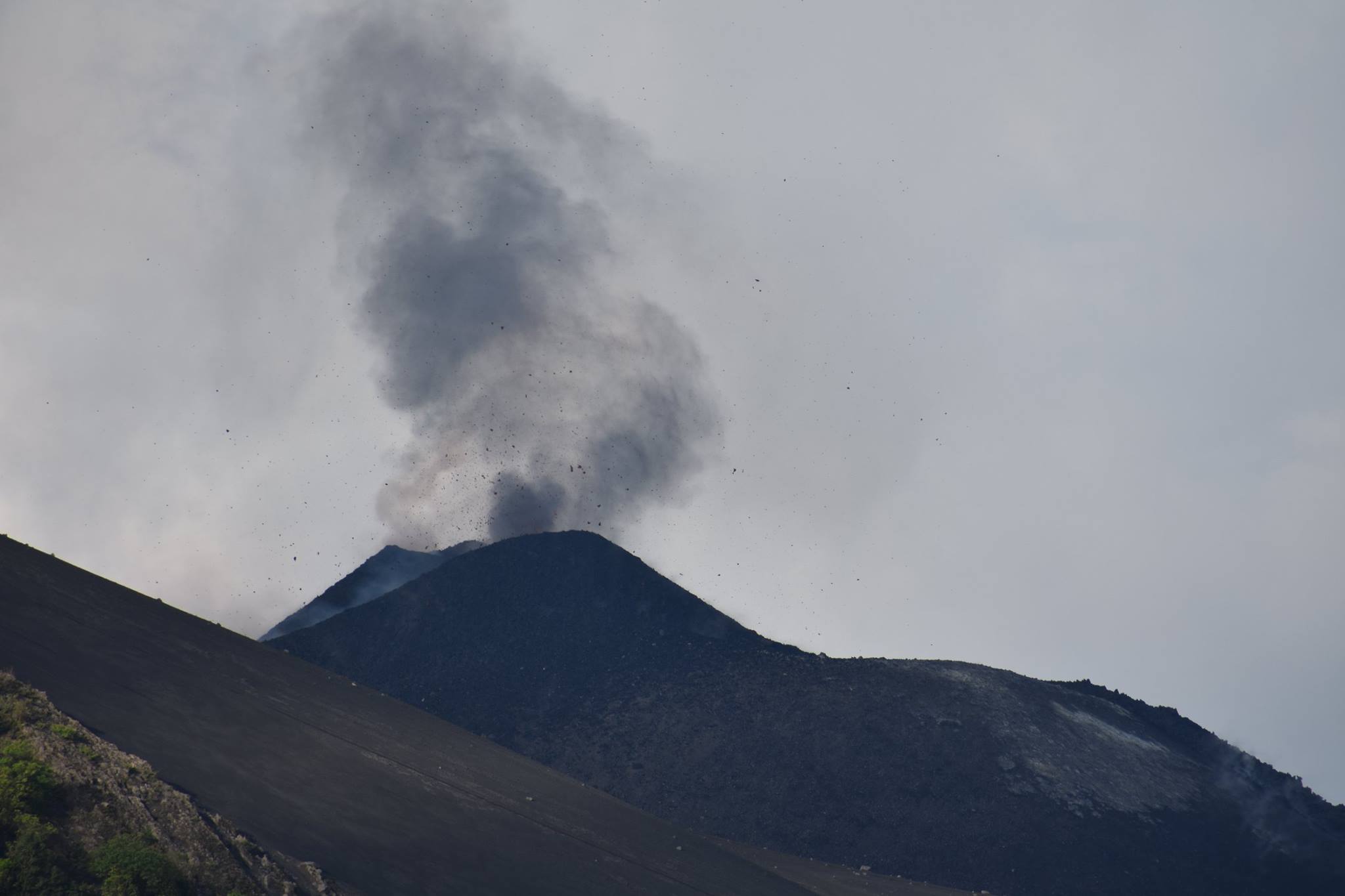
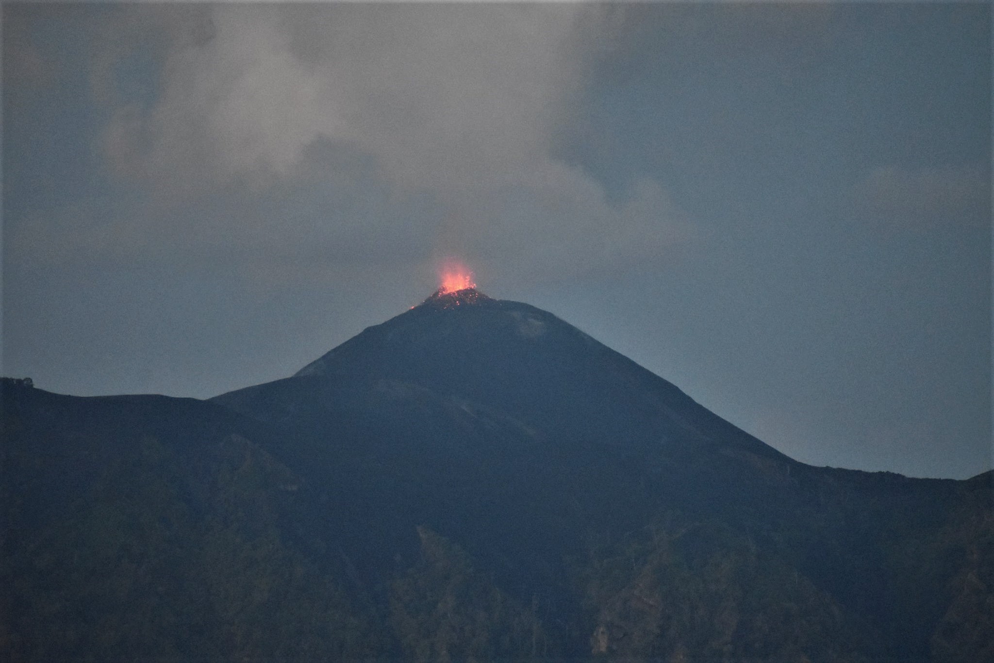
The administration of Poás Volcano National Park made the decision to close access to tourists for several hours Monday morning, due to increased activity in the crater of the volcano.
Gino Gonzalez, expert of Volcanes Sin Fronteras, told DIARIO EXTRA that the instruments placed on the point of view had detected irregularities and that the park rangers had warned, but from 10 o’clock. it was open again.
« There was an increase in the concentration of volcanic gases that was detected by the instruments in the surveillance zone and the rangers closed momentarily, » he said.
As a precaution, we evacuated the visitors who were in the area at the time and temporarily closed the park.
« We must continue to monitor the seismic signal and see, with the park rangers, if there is an increase in degassing, but there is a slight change in the activity of the volcano compared to a few days ago » said González.
In April 2017, the magmatic eruptions of Poas were probably one of the reasons for the degassing.
« This is part of the activity of a volcano that has recently erupted, we must continue to monitor the volcanic system, » concluded the volcanologist.
The Poás volcano will continue to receive tourists normally, while remaining under surveillance.
Source : .diarioextra.com
Photo : Natalia Paniagua / Volcanes Sin Fronteras.
Chile, Osorno :
During this period, 56 seismic events were recorded, of which 45 were classified as long period type (LP) events in relation to fluid dynamics within the volcano and / or glacial dynamics. The larger magnitude event had reduced displacement values (DRC) of 16.8 cm2. In addition, it has been classified 10 volcano_tectonic (VT) type events, associated with the fracturing of rigid materials. The larger energy event had a local magnitude (ML) equal to M 1.9 and was located 1.7 km north – northwest of the crater at a depth of 4.2 km.
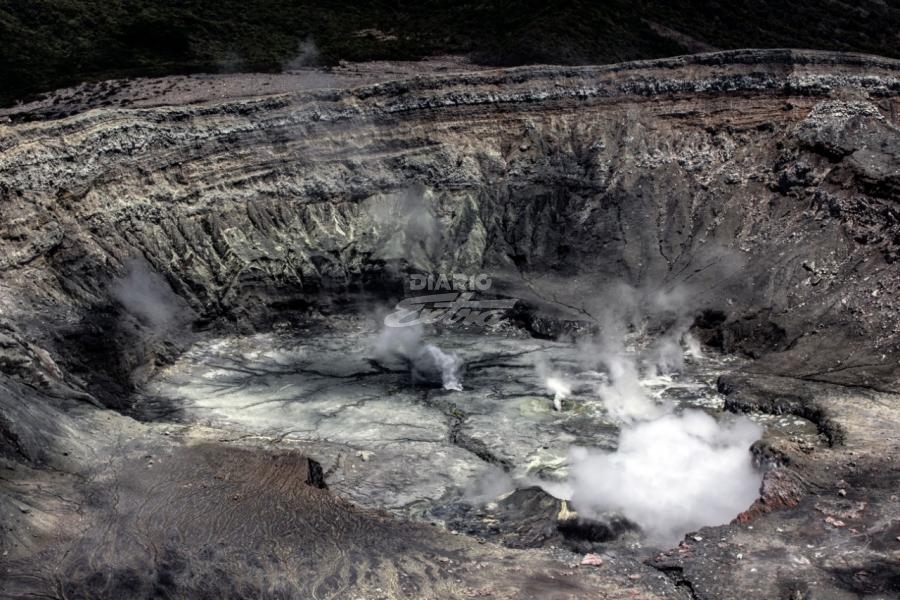
Surveillance camera images did not show any superficial activity when weather conditions allowed observation.
The indications of the electronic inclinometers did not reveal any changes in relation to changes in the internal dynamics of the volcano.

No emissions of sulfur dioxide (SO2) to the atmosphere in the volcano area have been reported, according to data published by the Ozone Monitoring Instrument (OMI) Sulfur Dioxide Group (http: / /so2.gsfc.nasa.gov/) and the National Satellite Environment and Information Data (NESDIS) (http: // satepsanoine nesdis.noaa.gov) ..
No thermal warnings have been reported in the volcano-associated area, according to data processed by Infrared, a means of observing volcanic activity (Mirova) (http://www.mirovaweb.it/) and MODVOLC (http : //modis.higp.hawaii.edu/).
Although the seismicity is maintained in similar values compared to the previous fortnight, we note the occurrence of processes which could according to their type cause the instability of the volcanic system, taking into account some episodes occurred sporadically during the previous months, with local magnitudes (ML) greater than M 3.0.
For the above, the volcanic alert is maintained at the level:
YELLOW LEVEL: Changes in the behavior of volcanic activity – Probable time for an eruption: WEEKS / MONTH.
Source : Sernageomin.
Photo : www.minube.com