August 27 , 2020 .
Italy / Sicily , Etna :
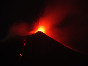
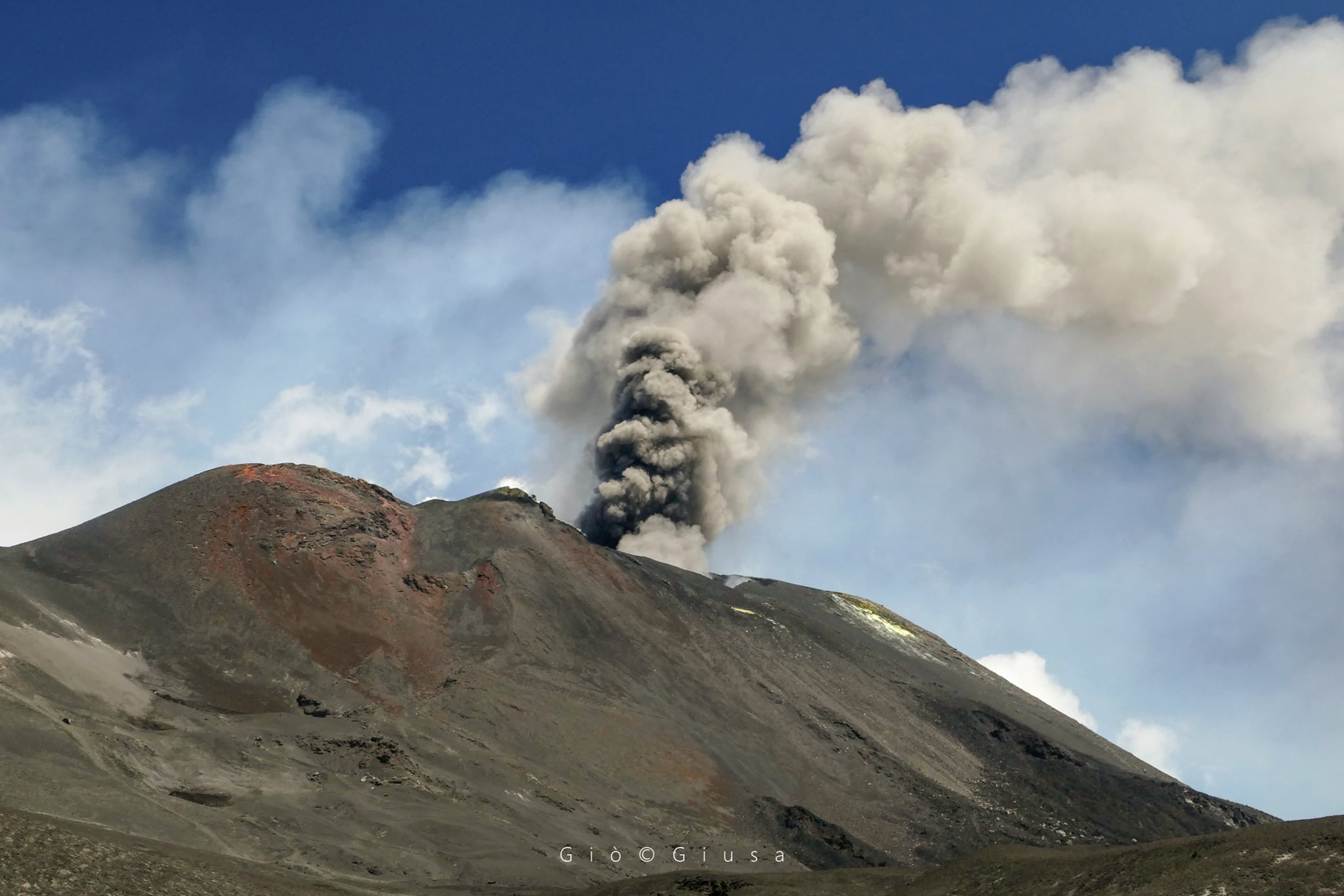
COMMUNICATION ETNA ACTIVITY [UPDATE n. 72], August 26, 2020.
The National Institute of Geophysics and Volcanology, Osservatorio Etneo, announces that during the night, the emission of ash continued from the New Southeast Crater, which caused a modest fall of ash to Catania. From the early hours of the morning, ash emissions gradually diminished. This phenomenon ceased from approximately 06:50 UTC.
As for the temporal trend of the mean amplitude of the volcanic tremor, it continues to present marked fluctuations which, on the whole, define a substantially stationary trend which is maintained mainly in the interval of the mean values. The location of the source of the tremor is located near the Southeast Crater / New Southeast Crater area, at an altitude of about 2900-3000 meters above sea level.
From the point of view of infrasound activity, no significant change is reported.
Soil deformation monitoring networks do not show significant variations.
Further updates will be communicated shortly.
Source : INGV.
Photo : Gio Giusa .
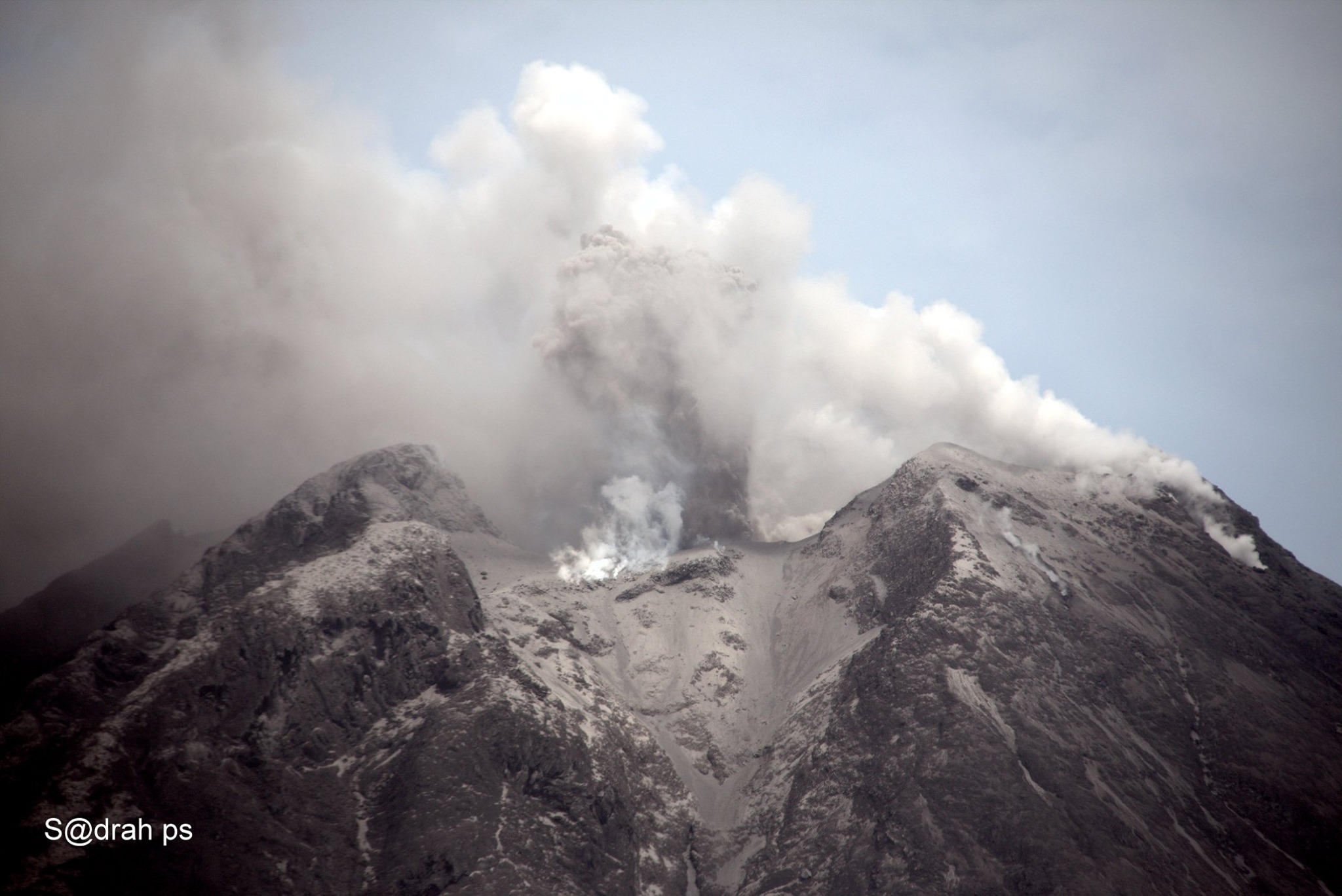
Indonesia , Sinabung :
The activity level has been at level III (SIAGA) since May 20, 2019 at 10:00 a.m. WIB. The Sinabung volcano (2460 m above sea level) has been erupting since 2013. The last eruption occurred on August 25, 2020, resulting in a column height of 800 meters above the summit.
The volcano is clearly visible until it is covered in fog. The crater emits white smoke with a moderate height, thick, about 300 meters above the summit. The weather is sunny to cloudy, the wind is weak, oriented to the South-West, West and North-West.
According to the seismographs of August 26, 2020, it was recorded:
12 emission earthquakes
2 low frequency earthquakes
3 local tectonic earthquakes
Continuous tremor of amplitude 0.5 to 3 mm, dominant value of 1 mm
Recommendation:
The community and visitors / tourists should not conduct activities in the villages that have been relocated, as well as within a radial radius of 3 km around the summit of Mount Sinabung, as well as within a sector radius of 5 km for the sector. South-East and 4 km for the East-North sector.
People who live near the rivers flowing down from Mount Sinabung should be aware of the dangers of lahars.
VOLCANO OBSERVATORY NOTICE FOR AVIATION – VONA.
Issued : August 25 ,2020
Volcano : Sinabung (261080)
Current Aviation Colour Code : ORANGE
Previous Aviation Colour Code : orange
Source : Sinabung Volcano Observatory
Notice Number : 2020SIN22
Volcano Location : N 03 deg 10 min 12 sec E 98 deg 23 min 31 sec
Area : North Sumatra, Indonesia
Summit Elevation : 7872 FT (2460 M)
Volcanic Activity Summary :
Eruption with volcanic ash cloud at 06:22 UTC (13:22 local). Eruption and ash emission is continuing.
Volcanic Cloud Height :
Best estimate of ash-cloud top is around 10432 FT (3260 M) above sea level, may be higher than what can be observed clearly. Source of height data: ground observer.
Other Volcanic Cloud Information :
Ash-cloud moving to west-nortthwest
Remarks :
Seismic activity is characterized by continuous volcanic tremor
Sources : PVMBG , Magma Indonésie .
Photo : Sadrah Peranginangin
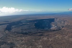
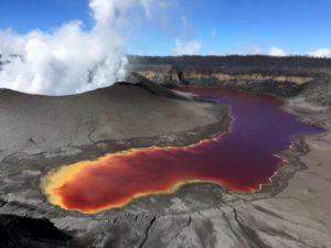
Hawaii , Mauna Loa :
19°28’30 » N 155°36’29 » W,
Summit Elevation 13681 ft (4170 m)
Current Volcano Alert Level: ADVISORY
Current Aviation Color Code: YELLOW
Activity Summary:
Mauna Loa Volcano is not erupting. Rates of deformation and seismicity have not changed significantly over the past week and remain above long-term background levels.
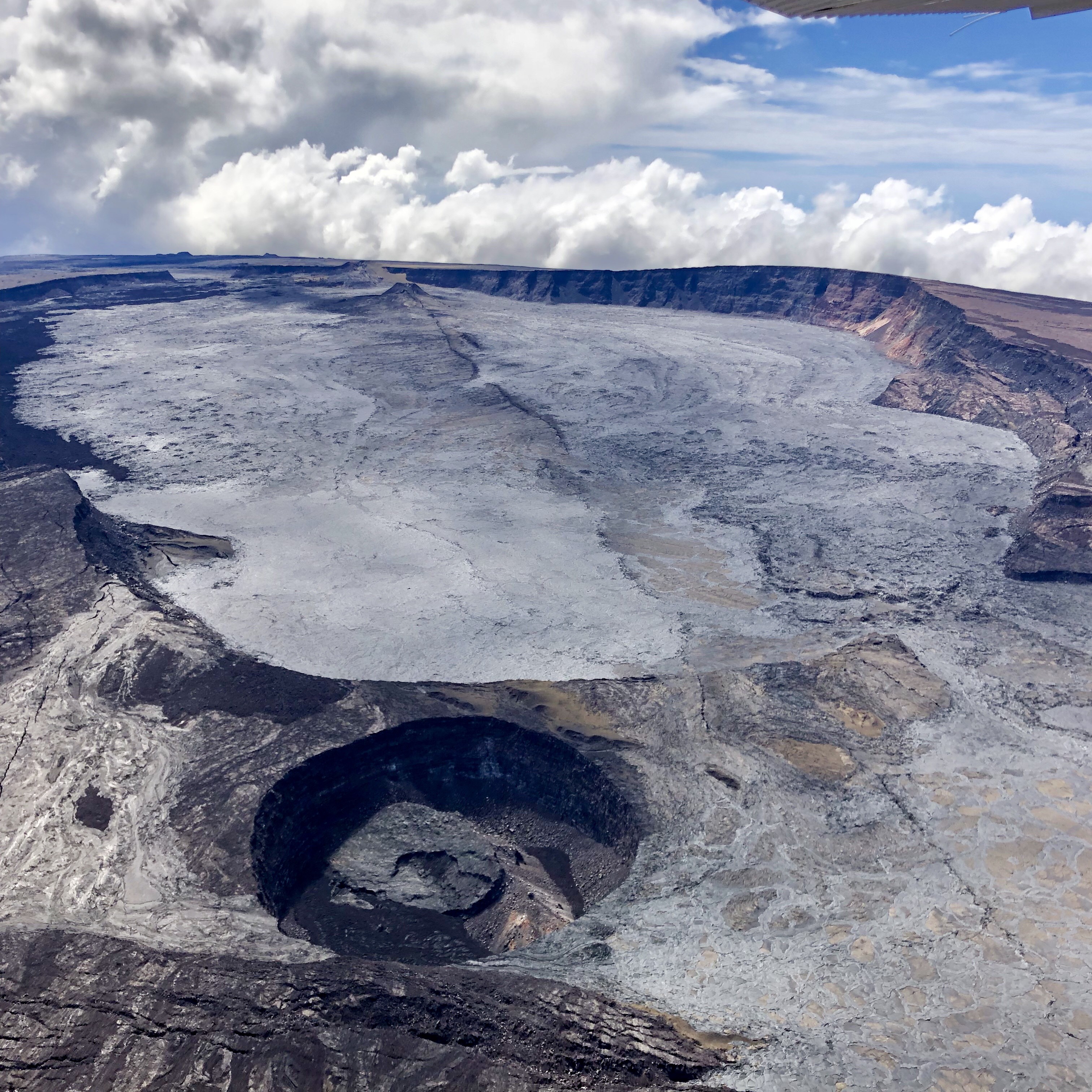
Observations:
Over the past week, HVO seismometers detected approximately 144 small-magnitude earthquakes (all below M2.5) below the volcano’s summit and upper-elevation flanks. Most of these earthquakes occurred at shallow depths of less than 8 kilometers, or approximately 5 miles, below ground level.
Global Positioning System (GPS) measurements show continued, slow inflation of the summit, consistent with magma supply to the volcano’s shallow storage system.
Gas concentrations at the summit and Sulphur Cone monitoring sites remain stable, both below 2 ppm SO2. Fumarole temperatures as measured at the summit are approximately 98 C, within the normal range; temperatures at Sulphur Cone are lower, but within the normal range for this site.
Webcam views have revealed no changes to the landscape over the past week.
Source et photo : HVO.
Japan , Sakurajima :
31.593°N, 130.657°E
Elevation 1117 m
JMA reported that very small eruptive events at Minamidake Crater (at Aira Caldera’s Sakurajima volcano) were recorded during 10-17 August. The daily sulfur dioxide emission rate was just over 1,000 tons/day on 13 August. During an overflight on 14 August observers noted that emissions were rising from multiple vents in the crater. The Alert Level remained at 3 (on a 5-level scale).
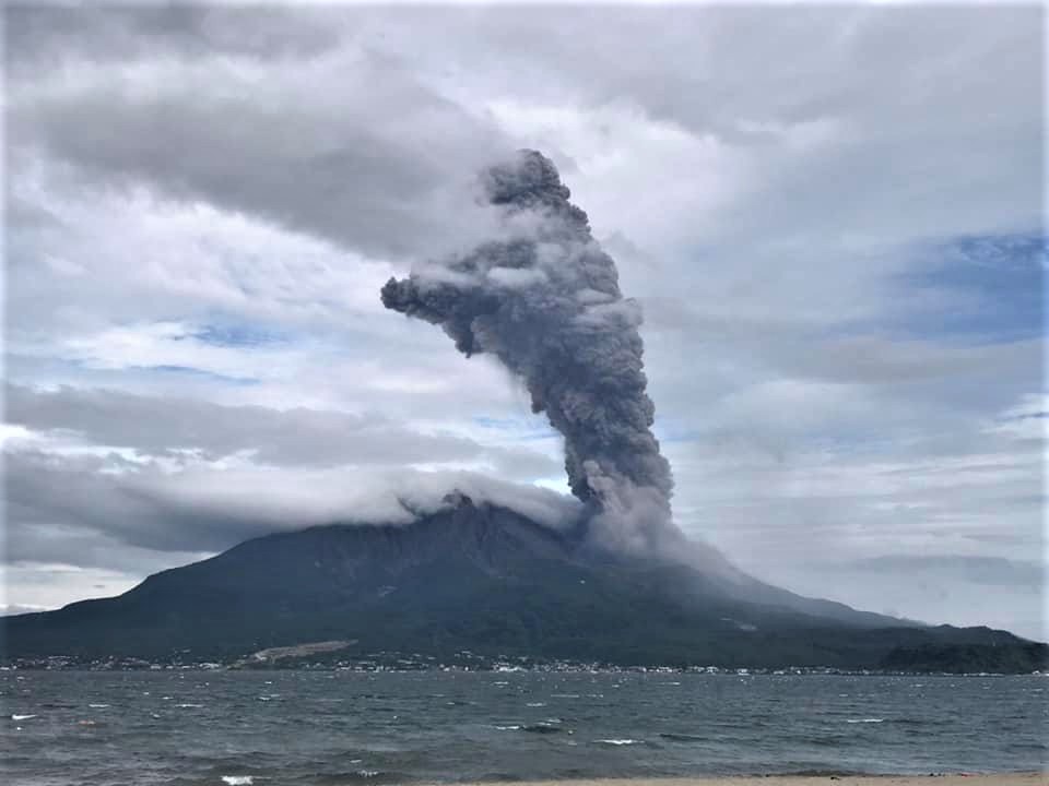
The Aira caldera in the northern half of Kagoshima Bay contains the post-caldera Sakurajima volcano, one of Japan’s most active. Eruption of the voluminous Ito pyroclastic flow accompanied formation of the 17 x 23 km caldera about 22,000 years ago. The smaller Wakamiko caldera was formed during the early Holocene in the NE corner of the Aira caldera, along with several post-caldera cones. The construction of Sakurajima began about 13,000 years ago on the southern rim of Aira caldera and built an island that was finally joined to the Osumi Peninsula during the major explosive and effusive eruption of 1914. Activity at the Kitadake summit cone ended about 4850 years ago, after which eruptions took place at Minamidake. Frequent historical eruptions, recorded since the 8th century, have deposited ash on Kagoshima, one of Kyushu’s largest cities, located across Kagoshima Bay only 8 km from the summit. The largest historical eruption took place during 1471-76.
Sources : GVP , JMA.
Photo : Koki Arima.
Ecuador , Reventador :
0.077°S, 77.656°W
Elevation 3562 m
IG reported that a high level of activity continued to be recorded at Reventador during 11-17 August. Gas, steam, and ash emissions observed sometimes multiple times a day with the webcam or reported by the Washington VAAC rose as high as 1 km above the summit crater and drifted NW and W. Cloudy weather sometimes prevented views of the volcano. Incandescent blocks rolled 500-700 m down mainly the NE and E flanks during 12-13 and 15-16 August. A lava flow traveled 200 m down the NE flank on 13 August. The flow lengthened to 300 m by 15 August and remained active, though did not advance, through 18 August. A small pyroclastic flow descended the NE flank during 15-16 August.
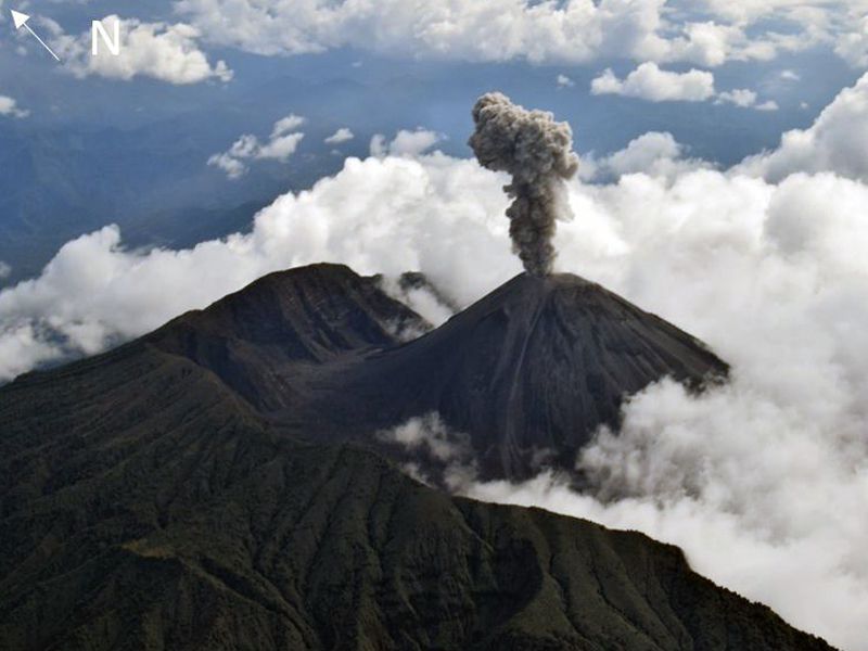
Emission column / ash:
Several gas and ash emissions were observed which rose 500 and 800 meters above the level of the crater, the direction was constant towards the southwest. The Washington VAAC reported 4 alerts of emissions observed by satellites, the direction of these varied from southwest to west, the heights remained at 1000 meters above crater level.
Observations:
Since the night and part of the morning today, the volcano was rather clear. At night, an incandescence was observed at the level of the crater due to the explosions recorded on the volcano and the rolling of boulders on its sides. The small lava flow (~ 350m) towards the North-East is maintained, always in the upper part.
The seismic statistics were carried out at the CASC station located in Dorado de Cascales, about 42 km from the Reventador volcano.
Source : GVP , IGEPN .
Photo : F Naranjo , GVP.