August 14 , 2020.
Indonesia , Sinabung :
Press release on the activity of G. Sinabung – North Sumatra / August 13, 2020
Aug 14, 2020
Geographically, Mount Sinabung is located at the position of coordinates 3 ° 10 ‘North and 98 ° 23.5’ East Longitude, with a maximum height of 2460 m Administratively, the G. Sinabung is included in the Karo district, province from North Sumatra and is observed visually and instrumentally from the Volcano Observation Post (PGA) in the village of Ndokum Siroga, Simpang Empat district, Karo regency, North Sumatra province.
The activity level of G. Sinabung has been level III (SIAGA) since May 20, 2019.

Surveillance data:
Visual:
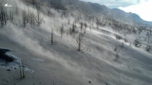
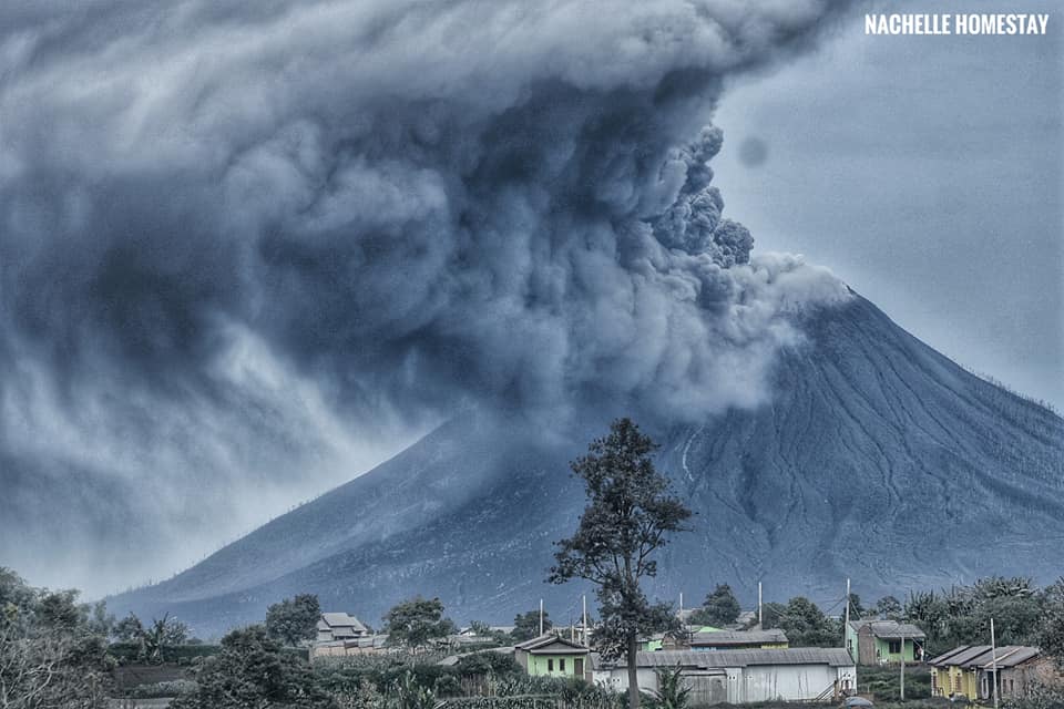
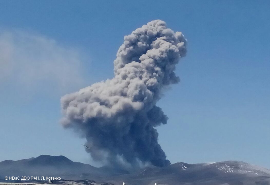
After two eruptions on August 8, 2020, two eruptions occurred on August 10, 2020, resulting in a column of gray-white eruption 200 to 5,000 m high above the summit of the peak. On August 13, 2020 until 9:41 p.m. WIB, 7 eruptions occurred, resulting in a column of gray eruption of moderate intensity, reaching a maximum of 2000 m above sea level above the summit of the peak. The eruption column moved east, southeast and south.
Seismicity:
The types of earthquakes recorded from August 8 to 12 were: 4 eruption earthquakes, 86 emission earthquakes, 2 Tornillo earthquakes, 15 low frequency earthquakes, 99 earthquakes deep volcanic earths, 3 local tectonic earthquakes, 7 shallow tectonic earthquakes, and a continuous tremor. The series of eruptions of August 13, 2020 were dominated by continuous tremors with a maximum amplitude of 0.5 to 15 mm (dominant value 3 mm).
Analysis:
Continuous tremor recordings show that the magma migration process always occurs from depth to the surface.
The series of eruptions of August 13, 2020 and the character of the eruptions indicate that there is a potential for an explosive eruption to produce hot eruption clouds.
Potential danger:
Given the nature and character of the current eruption of Mount Sinabung, the eruption coincides with the appearance of hot clouds, the dangerous threat is heavy ash rain around the summit and slopes of Mount Sinabung. Ash material can be carried further from the summit, depending on the direction and speed of the wind.
https://www.facebook.com/endrolewa/videos/1231081627232817/
Conclusion:
The volcanic activity of Mount Sinabung is still ongoing, but the potential danger from the distribution of eruption products and hot cloud slides is still within the recommended radius of the disaster prone area. The activity level of G. Sinabung is level III (SIAGA).
Recommendation:
At activity level III (SIAGA), the community and visitors / tourists should not perform activities in villages that have been relocated, as well as within a radial radius of 3 km around the summit of G. Sinabung , and a sector radius of 5 km for the South-East sector, and 4 km for the East-North sector.
Source : PVMBG.
Video : Endro Lewa.
Photos : Firdaus Surbakti , Nachelle Homestay Tour & Travel.
Russia / Kurile Islands , Ebeko :
VOLCANO OBSERVATORY NOTICE FOR AVIATION (VONA).
Issued: August 13 , 2020
Volcano: Ebeko (CAVW #290380)
Current aviation colour code: ORANGE
Previous aviation colour code: orange
Source: KVERT
Notice Number: 2020-171
Volcano Location: N 50 deg 41 min E 156 deg 0 min
Area: Northern Kuriles, Russia
Summit Elevation: 3791.68 ft (1156 m)
Volcanic Activity Summary:
A moderate eruptive activity of the volcano continues. According to visual data by volcanologists from Severo-Kurilsk, explosions sent ash up to 2.0 km a.s.l., an ash cloud is drifting to the south of the volcano.
This eruptive activity continues. Ash explosions up to 19,700 ft (6 km) a.s.l. could occur at any time. Ongoing activity could affect low-flying aircraft and airport of Severo-Kurilsk.
Volcanic cloud height:
6560 ft (2000 m) AMSL Time and method of ash plume/cloud height determination: 20200813/2235Z – Visual data
Other volcanic cloud information:
Distance of ash plume/cloud of the volcano: 6 mi (10 km)
Direction of drift of ash plume/cloud of the volcano: S
Time and method of ash plume/cloud determination: 20200813/2235Z – Visual data
Source : Kvert .
Photo : L. Kotenko, IVS FEB RAS , 2017.
Italy , Stromboli :
STROMBOLI PRESS RELEASE [UPDATE n. 3]
The National Institute of Geophysics and Volcanology, Osservatorio Etneo, reports that an explosive event occurred at 14:50:27 UTC (16:50:27 local time) in the south-central area of the crater terrace from Stromboli. The explosion, which generated a distinct seismic signal, emitted a dense plume of ash 150 m above the summit of the volcano, which dispersed to the southeast. The recordings of the thermal surveillance cameras show the presence of hot material in the plume. However, no fallout of pyroclastic material was observed on the Sciara del Fuoco; a phenomenon which rather occurred during other explosions during the day.
After the explosion at 2:50:37 PM, the volcano’s normal explosive activity continued.
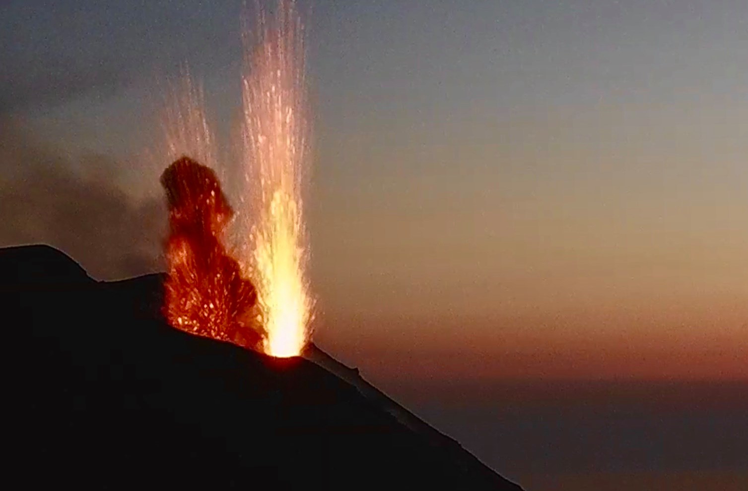
Seismically, the phenomenon was characterized by a short sequence of explosive events that started at 14:49:25 UTC and ended the following minute. It should be noted that the explosion visible on the images of the surveillance cameras was only one, however, as described above.
Currently the amplitude of the volcanic tremor, the frequency and the energy of the explosions show a stationary image, comparable to the period preceding the publication of the press release.
From the observation of the parameters relating to the deformations of the ground, no significant variation is detected.
In summary, the event is part of Stromboli’s normal explosive activity.
STROMBOLI PRESS RELEASE [UPDATE n. 4]
The National Institute of Geophysics and Volcanology, Osservatorio Etneo, announces that the monitoring networks recorded the return of parameters to normal activity at 19:26 (17:26 UTC).
Further updates will be communicated shortly.
Source : INGV.
Photo : Webcam
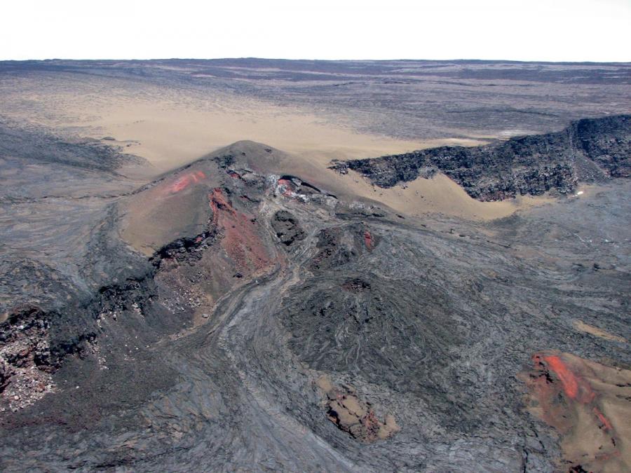
Hawaii , Mauna Loa :
19°28’30 » N 155°36’29 » W,
Summit Elevation 13681 ft (4170 m)
Current Volcano Alert Level: ADVISORY
Current Aviation Color Code: YELLOW
Activity Summary:
Mauna Loa Volcano is not erupting. Rates of deformation and seismicity have not changed significantly over the past week and remain above long-term background levels.
Observations:
Over the past week, HVO seismometers detected approximately 164 small-magnitude earthquakes (all below M2.5) below the volcano’s summit and upper-elevation flanks. Most of these earthquakes occurred at shallow depths of less than 8 kilometers, or approximately 5 miles, below ground level.
Global Positioning System (GPS) measurements show continued, slow inflation of the summit, consistent with magma supply to the volcano’s shallow storage system.
Gas concentrations at the summit and Sulphur Cone monitoring sites remain stable, both below 2 ppm SO2. Fumarole temperatures as measured at the summit are approximately 98 C, within the normal range; temperatures at Sulphur Cone are lower, but within the normal range for this site.
Webcam views have revealed no changes to the landscape over the past week.
Source et photo : HVO.
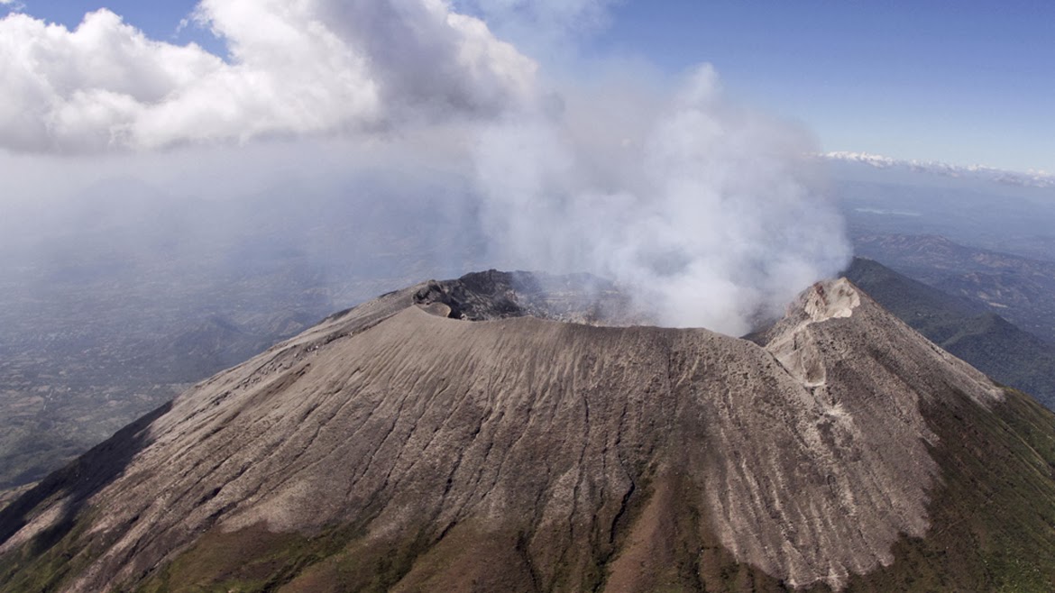
El Salvador , San Miguel (Chaparrastique) :
Location: San Miguel department
Altitude: 2130 meters above sea level
Type of volcano: Stratovolcano
Type of activity: Strombolian-Vulcanian
Last significant eruption: December 29, 2013
During the month of July, the San Miguel volcano presented a level of activity very similar to that of June, that is to say normal. The seismic vibration remained below the threshold of 150 RSAM units, oscillating between 44 and 62 RSAM units on average per day. No earthquake was perceived by the population living in the area of the volcano.
Sulfur dioxide (SO2) emissions remained fluctuating between 141 and 325 tonnes per day, i.e. below the threshold of 620 tonnes / d, indicating that there had been no increase supply of magma. The activity of the volcano is therefore at a normal level. However, it is not excluded that a magmatic ascent could occur and suddenly change the activity, as it has already been the case, therefore it is suggested to climbers and the general population to avoid visiting the area. from the crater.
Source : Marn .
Photo : Marn / Epa