August 08 , 2020.
Japan , Nishinoshima :
Volcanic ash from Japanese island reaches E. Taiwan
Impact on local environment limited due to 2,000-km distance from Nishinoshima
TAIPEI (Taiwan News) — Volcanic dust from an eruption on the Japanese island of Nishinoshima was responsible for a sudden turn for the worse in air quality on Taiwan’s sparsely populated east coast Thursday evening (Aug. 6), according to weather experts.
The counties of Yilan, Hualien, and Taitung are known for their fresh air and natural beauty, but late on Thursday the eastern sky turned gray and the air quality went from excellent to average, CNA reported. On the Facebook page WeatherRisk, Central Weather Bureau Director-General Cheng Ming-dean (鄭明典) said the change was not the result of simple environmental pollution but eruptions at the Nishinoshima volcano 2,000 km away.
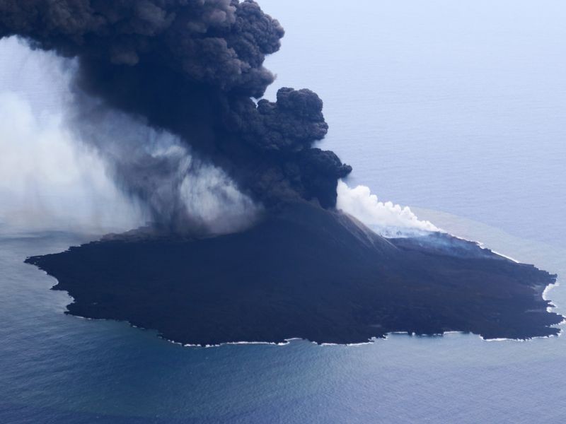
The islet in the Ogasawara archipelago, also known as Rosario Island, has been growing for 40 years due to volcanic activity.
Due to the distance of the eruption, the ash and dust have become less dense, and their impact will gradually diminish over the course of Friday (Aug. 7), weather experts said. The dust first drifted west and then turned north before being blown south along Taiwan’s east coast by shifting winds.
According to meteorological and reverse trajectory simulation data from the Central Meteorological Bureau, volcanic ash that was emitted from the Nishinoshima volcano in Japan began to affect air quality in the northern and eastern parts of Taiwan as high pressure from the Pacific has spread westward since last night. According to monitoring data, the concentration of fine airborne particles (PM2.5) is mainly between 20 and 40 micrograms per cubic meter, and the air quality is mainly of ordinary level.
Source : taiwannews.com. UDN.com
Read the article : https://www.taiwannews.com.tw/en/news/3982620?fbclid=IwAR3hrQW6BFClwPSe3LUzpahzAiwhinVfXn4k3aP6GIvncxbEGQrul0MJnLs
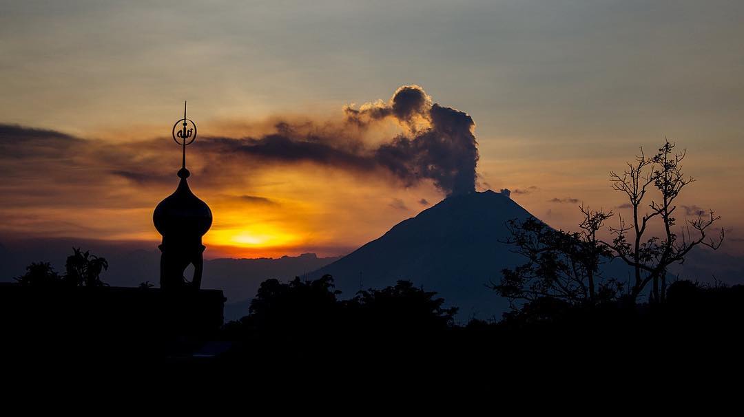
Indonesia , Merapi :
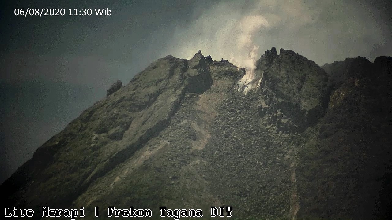
Mount Merapi activity report from July 31 to August 6, 2020.
OBSERVATION RESULTS
Visual
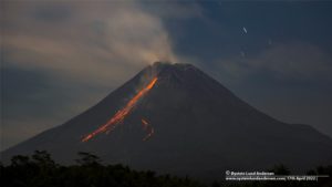
The weather around Mount Merapi is generally sunny in the morning and at night, while the afternoon to evening is foggy. The smoke is white, thin to thick with low pressure. A maximum smoke height of 200m is observed from the Mount Merapi observation post in Selo on August 5, 2020 at 06:30 WIB.
Morphological analysis of the crater area based on photos of the Southeast sector showed no change in the morphology of the dome. The volume of the lava dome based on measurements using aerial photos with drones on July 26, 2020 is 200,000 m3.
Seismicity:
This week, the seismicity of Mount Merapi recorded:
11 earthquakes of emissions (DG),
10 shallow volcanic earthquakes (VTB),
56 multiphase earthquakes (MP),
2 low frequency earthquake (LF),
36 avalanche earthquakes (RF),
16 tectonic earthquakes (TT).
The seismic intensity this week is relatively higher than last week.
Deformation:
The deformation of Mount Merapi which was monitored by EDM this week showed a shortening of the distance between the markers of about 2 cm.
Rain and lahars:
This week, there have been no reports of rain and lahars or additional flow in the rivers flowing down from Mount Merapi.
Conclusion
Based on the results of visual and instrumental observations, it is concluded that:
1. The lava dome is currently in stable condition.
2. The volcanic activity of Mount Merapi is still quite high and is within the “WASPADA” activity level.
3. Potential dangers today are hot clouds from the collapse of the lava dome and the eruption of volcanic material from explosive eruptions.
Chile , Villarica :
Yesterday at 3:22 p.m. local time, an explosion occurred on the Villarrica volcano, associated with a long-term earthquake (movement of fluids) with a reduced displacement of 12 cm2. The activity was accompanied by an infrasound signal of 10 pascal, 1 km from the crater.
Particulate matter from the column dispersed to the southeast, depositing a layer of ash on the snow.
For this reason, the Enemy indicated that it was maintaining its technical alert at the active Yellow level. According to the organization, this is due to the fact that « the volcano is above its baseline and the process is unstable, and can evolve even increasing or decreasing these levels, so a probable eruption could develop in a period of several weeks or months »
.

According to the information provided by OVDAS – SERNAGEOMIN, the Villarrica volcano maintains the technical alert level at the yellow level, which includes variations in the levels of parameters derived from monitoring that indicate that the volcano is above its threshold of base and the process is unstable, being able to progress by increasing or decreasing these levels, therefore a probable rash could develop within a period of several weeks or months.
Based on what is stated in the latest RAV, issued during this day, which includes the period between July 16 and July 31, 2020, it is reported that the volcanic monitoring parameters are at levels considered low for this volcano. However, constant surface activity, with visible passive degassing during the day, sporadic emissions of particles and the presence of nocturnal incandescence, accompanied by satellite thermal anomalies and the recording of acoustic signals associated with minor explosions , suggest that the system still has the capacity to spontaneously generate ballistic emissions around the crater.
It could also facilitate an untimely escalation in levels of volcanic activity. It should be noted that the behavior of the lava lake is fluctuating, and that it continues to be located near the surface, causing minor explosions that can affect the vicinity of the crater.
Sources :Onemi /Sernageomin .
Photos: AngaritaVPhotography , Sernageomin via Volcanologia en Chile.
Indonesia , Sinabung :
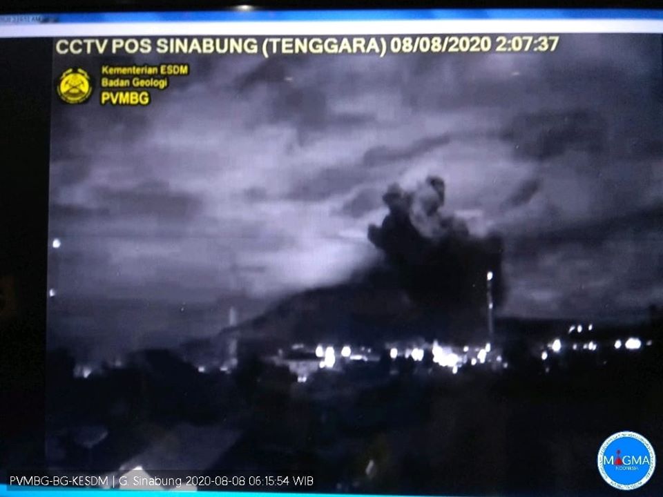
Press release Activity of G. Sinabung – North Sumatra, August 08, 2020
3 ° 10 ‘North latitude and 98 ° 23.5’ East longitude
The activity level of G. Sinabung has been level III (SIAGA) since May 20, 2019.
Surveillance data:
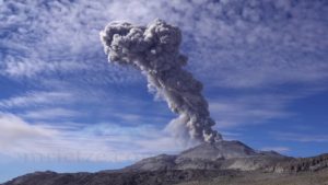
Visual: During the period July 1 to August 7, 2020. The volcano is clearly visible until it is covered with fog. The main crater shows faint to thick white smoke with a height of around 50-500 meters above the summit. On August 8, 2020 at 1:58 a.m., an eruption occurred, causing a column of gray / brown eruption, about 2000 m above sea level above the summit of the peak, of moderate to thick intensity. The eruption column dispersed to the east.
Seismicity: The number and types of earthquakes recorded from July 1 to August 7, 2020 at 12:00 a.m. were dominated by emission earthquakes, local tectonics, and distant tectonic earthquakes.
On August 7, 2020, it was recorded
15 emission earthquakes,
6 low frequency earthquakes,
21 deep volcanic earthquakes
2 distant tectonic earthquakes.
there has been an increase in volcanic earthquakes. August 8, 2020 at pkl. 01:58 WIB an eruption earthquake with a maximum amplitude of 120 mm and a duration of 1 hour 44 seconds was recorded.
Analysis:
The eruption that occurred was phreatic in nature, not preceded by a significant increase in volcanic earthquakes, indicating the lack of magma supply to the surface. The eruption that occurred on August 8, 2020 was more due to overpressure and surface activity.
The eruptions lasted only briefly, not followed by an increase in seismicity and visual changes leading to a larger series of eruptions.
Potential danger:
Given the nature and character of the eruptions from Mount Sinabung, currently the potential for explosive eruptions is still there, with the risk of hot cloud eruptions.
Currently, the potential danger comes in the form of heavy ash rains around the summit of Mount Sinabung. Ash material can be carried further from the summit, depending on the direction and speed of the wind.
Conclusion:
The volcanic activity of Mount Sinabung fluctuates, both visually and instrumentally. There was no sign of a change in the nature of the rash or of an increased potential for danger. The distribution of material for the August 8, 2020 eruption is still within the recommended radius of the disaster-prone area. G. Sinabung’s activity level is level III (SIAGA).
Recommendation:
At level III activity level (SIAGA) the community and visitors / tourists do not carry out activities in the villages that have been relocated, as well as within a radial radius of 3 km around the summit of G. Sinabung, and a sector radius of 5 km for the South-East sector, and 4 km for the East-North sector.
Source : PVMBG.
Photos : PVMBG , Auteur inconnu .
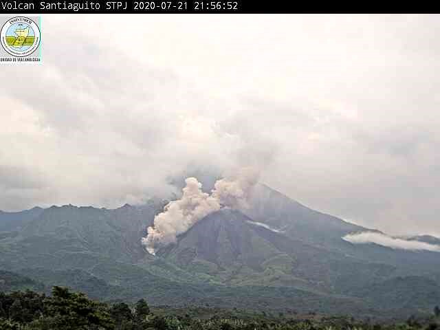
Guatemala , Santiaguito :
Special volcanological bulletin.
Type of activity: Pelean
Morphology: Complex of dacitic domes
Geographical location: 14 ° 44 ’33 ˝ Latitude N; 91 ° 34’13˝ Longitude W
Height: 2500msnm.
ACTIVITY UPDATE
The Santiaguito volcano maintains the same eruptive pattern of the past few weeks, where a constant activity of boulder avalanches and channeled ash is observed on the western flank of the Caliente dome, with sometimes also columns of ash that form a curtain that disperses in the region . On the eastern flank, avalanches are also observed but in lesser quantity.
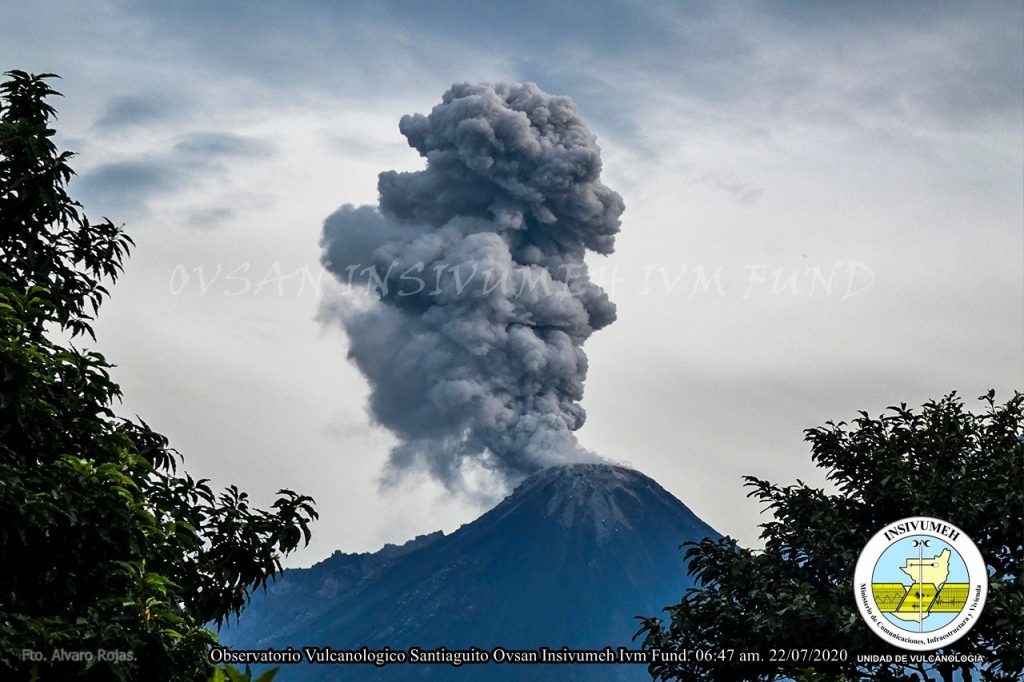
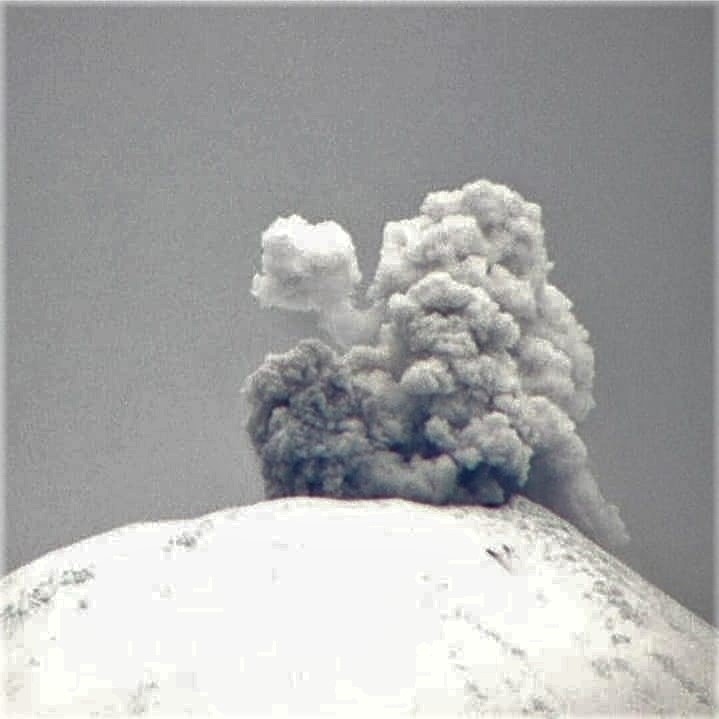
Figure n ° 1: Pyroclastic flow recorded by the INSIVUMEH surveillance camera on July 21 (top image). Degassing column generated by the Caliente dome
(image below) seen from OVSAN on July 22.
In the Caliente Dome crater, the explosions remain weak to moderate, some ash-laden reaching 3300 to 3600 meters (10,826 to 11,811 feet) which is dispersed in the wind direction for about 10 and 12 kilometers, on the communities in the Palajunoj region. Some explosions are accompanied by reaction turbine-type degassing sounds audible 5 kilometers from the volcanic building.
The activity described has been maintained over the past few weeks, however, an increase in explosions and boulder avalanches and even greater pyroclastic flows cannot be excluded.
Source : Insivumeh / Fredy Arnoldo Esquit Chiquitá le 7 août 2020 à 17:28 heure locale