August 01 , 2020.
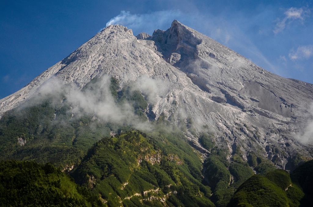
Italy / Sicily , Etna :
ETNA PRESS RELEASE [UPDATE n. 62]
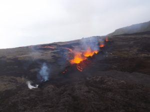
The National Institute of Geophysics and Volcanology, Osservatorio Etneo, reports that in recent hours there has been an increase in Strombolian activity in the New Southeast Crater clearly visible from surveillance images of INGV-OE. This activity forms a diluted volcanic cloud which disperses in a southwest direction and reached a height of about 4.5 km above sea level. Strombolian activity continues at the level of the Voragine crater which produces sporadic emissions of volcanic ash. INGV-OE personnel present in the summit area during this week also observed the presence of deep intracrater Strombolian activity at the Northeast Crater.
https://www.facebook.com/ingvvulcani/videos/620963508541901/
Between 8:30 am and 10:00 am UTC on July 28, there was a sudden decrease in the amplitude of the volcanic tremor. Immediately thereafter, a gradual increase in the amplitude value of the tremor began, which peaked on the late evening of July 30 while remaining within the average values. The location of the source of the tremor does not show significant variations, being confined to the area of the New Southeast Crater, at an altitude of 2900-3000 m above sea level. From the infrasound point of view, no significant activity was reported.
The deformations of the ground do not show significant variations observable from the GNSS and inclinometric networks.
Further updates will be communicated shortly.
Source : INGV
Japan , Nishinoshima :
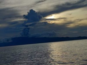
Nishinoshima, in the Ogasawara Islands in Tokyo, experienced its largest eruption since the eruption resumed in 2013. On July 30, it was possible to observe gray smoke emanating from the crater which reached a height of about 3000 meters , passing through thin clouds in the sky and flying south from Asuka’s plane. Until now, the rugged black lava had spread, but on that day the whole island was covered in brown volcanic ash several meters thick.

According to Setsuya Nakata, the director of the Volcano Research Promotion Center, who was aboard the head office machine, lava was actively flowing until early July, but « the magma momentum has diminished and the groundwater is entered the crater, The suddenly cooled magma breaks and erupts violently as volcanic ash. »
According to a Japanese Coast Guard investigation, Nishinoshima, located about 1,000 kilometers south of central Tokyo, erupted for the first time in 40 years. It covered the original island. It stopped in the summer of 2018, but at the end of last year the volcano resumed its eruption for the first time in a year and a half, and on July 4 it had the largest volcanic plume of 8300 meters from the history of observation. In the past six months, it has grown twice on the north side of the island. (Yu Fujinami)
Source : Asahi Shimbun.
Photo: naoko kawamura.
Kamchatka , Karymsky :
54.05 N, 159.44 E;
Elevation 4874 ft (1486 m)
Aviation Colour Code is ORANGE
A moderate gas-steam activity of the volcano continues. Ash explosions up to 16,400-23,000 ft (5-7 km) a.s.l. could occur at any time. Ongoing activity could affect low-flying aircraft.
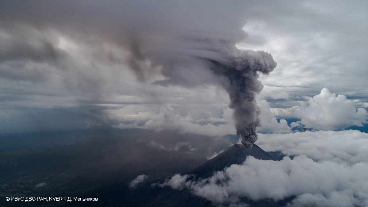
A moderate gas-steam, and sometimes the Strombolian and Vulcanian activity of the volcano continues. Satellite data shows a thermal anomaly over the volcano all week; explosions sent ash up to 3.0-3.5 km a.s.l. on 27-30 July, ash clouds drifted for 250 km to the south-west and south-east of the volcano.
Source : Kvert.
Photo : D. Melnikov, IVS FEB RAS, KVERT
Indonesia , Merapi :
Activity report of the Merapi volcano from July 24 to 30, 2020
OBSERVATION RESULTS
Visual
The weather around Mount Merapi is generally sunny in the morning and night, while the day until evening is foggy. There is white smoke, thin to thick with low pressure. The maximum smoke height of 200m was observed from the Mount Merapi observation post in Babadan on July 25, 2020 at 5:40 a.m. WIB.
Morphological analysis of the crater area from photographs of the southeast sector did not show any change in the morphology of the dome. The volume of the lava dome based on measurements using aerial photography with drones on July 26, 2020, estimated at 200,000 m3. remains relatively unchanged from the measurement data of July 11, 2020.

Seismicity:
During this week, the seismicity of Mount Merapi recorded:
16 emission earthquakes (DG),
2 deep volcanic earthquakes (VTA),
44 Multiple Phase (MP) earthquakes,
3 low frequency earthquakes (LF),
37 avalanche earthquakes (RF),
19 tectonic earthquakes (TT).
The seismic intensity this week is relatively lower than last week
.
Deformation:
Information from G. Merapi monitored using EDM and GPS this week showed no significant changes.
Rain and lahars:
This week there have been no reports of rain and lahars, nor additional flows in the rivers flowing down from Mount Merapi.
Conclusion:
Based on the results of visual and instrumental observations, it was concluded that:
1. The lava dome is currently in stable condition.
2. The volcanic activity of Mount Merapi is still quite high and determined by the level of “WASPADA” activity.
3. The hazard potential today is in the form of a hot cloud from the collapse of the lava dome and explosions of volcanic material from explosive eruptions.
Source : BPPTKG.
Photos : Frekom , Azimuth Adventure Travel .
United – States , Volcanoes of California :
CALIFORNIA VOLCANO OBSERVATORY WEEKLY UPDATE , U.S. Geological Survey
Tuesday, July 28, 2020, 9:50 AM PDT (Tuesday, July 28, 2020, 16:50 UTC)
Current Volcano Alert Level: all NORMAL
Current Aviation Color Code: all GREEN
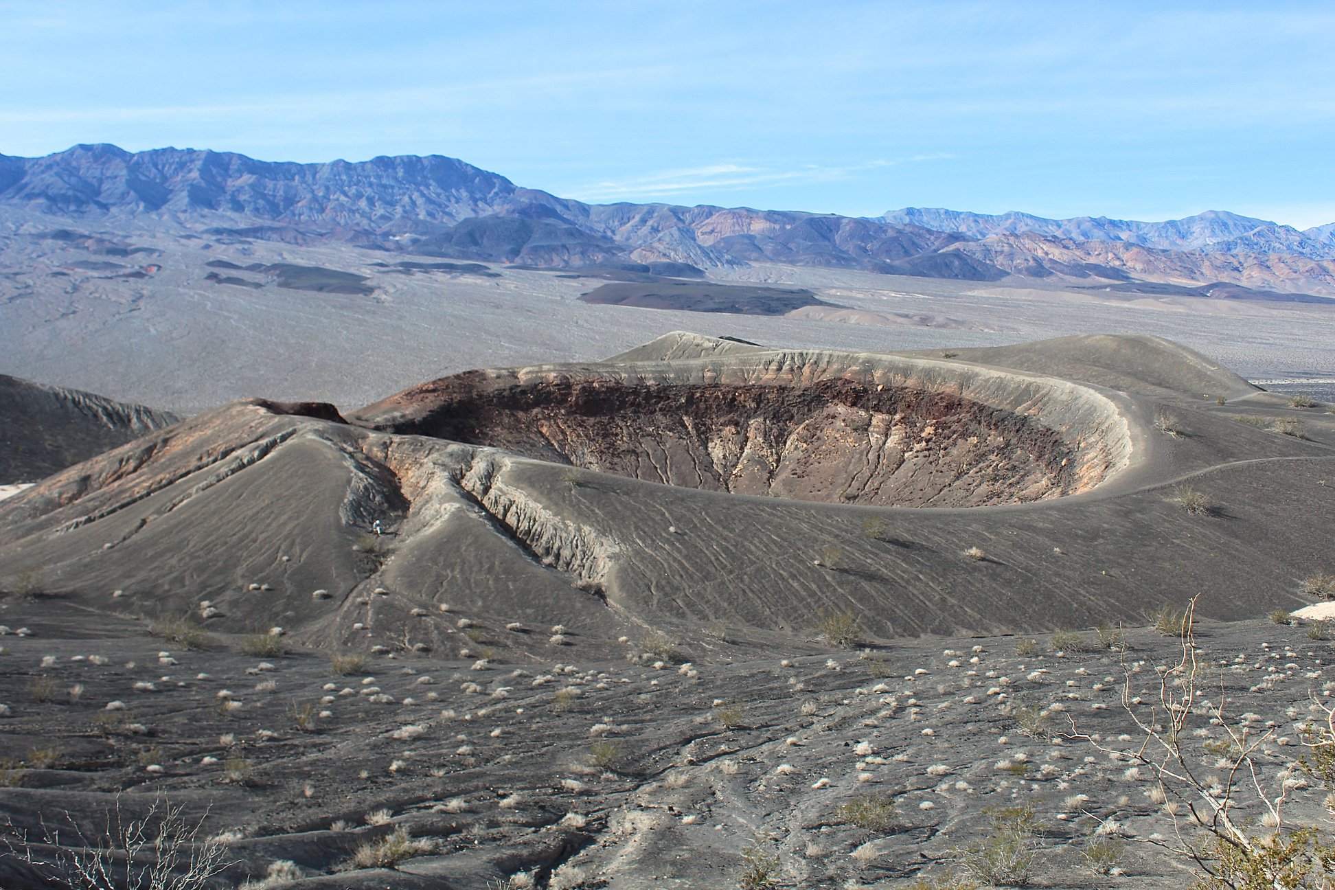
Activity Update: All volcanoes monitored by CalVO using telemetered, real-time sensor networks exhibit normal levels of background seismicity and deformation. Volcanoes monitored include Mount Shasta, Medicine Lake Volcano, Clear Lake Volcanic Field, Lassen Volcanic Center, Long Valley Volcanic Region, Coso Volcanic Field, Ubehebe Craters, and Salton Buttes.
Observations for July 20, 2020 (0000h PDT) through July 26, 2020 (2359h PDT):
Clear Lake Volcanic Field: One earthquake at or above M1.0 was detected, measuring M2.2. As is typical, moderate levels of seismicity were recorded at the Geysers geothermal steam field south of the Clear Lake Volcanic Field; 44 earthquakes at or above M1.0 were detected, with the largest event measuring M2.5.
Lassen Volcanic Center: No earthquakes at or above M1.0 were detected.
Long Valley Volcanic Region: In the Long Valley Caldera, 126 earthquakes of M1.0 or greater were detected, with the largest event measuring M2.7. Under Mammoth Mountain, 4 earthquakes of M1.0 or greater were detected, with the largest event measuring M2.2. No earthquakes at or above M1.0 were detected in the Mono-Inyo Craters. As is typical, moderate levels of seismicity were observed south of the caldera in the Sierra Nevada range; 10 earthquakes at or above M1.0 were detected, with the largest event measuring M2.3.
Mount Shasta: No earthquakes at or above M1.0 were detected.
Medicine Lake: No earthquakes at or above M1.0 were detected.
Salton Buttes: 1 earthquake at or above M1.0 was detected, measuring M1.3.
Coso Volcanic Field: 7 earthquakes at or above M1.0 were detected, with the largest event measuring M1.8.
Ubehebe Craters: No earthquakes at or above M1.0 were detected.
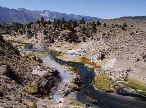
Relative to previous weeks, an increase in seismicity at Long Valley occurred as three distinct swarms between July 22-24 with sporadic activity continuing through the end of this reporting period. The seismicity was centered about 1 km north of the Mammoth airport, with most events at depths of 6 km. Nearly 400 earthquakes have been located during this sequence of activity, most with magnitudes less than M1.0. The location of this swarm is near the northern end of the Hilton Creek Fault and the character of these events suggests that they are happening due to slip on a well defined fault. There are abundant hydrothermal fluids in this part of the caldera, and changes in fluid pressure at depth could possibly be the cause of the slip and seismicity. At the present time, the rate of seismicity appears to be decreasing; however, similar activity in 2014 occurred in the same region with thousands of events recorded over a period of several months.
Source : Calvo / USGS .
Photos : Judy Fierstein, USGS, 2018 , Chris Farrar / wikipedia (long valley caldeira) .