26 Aout 2020.
Italy / Sicily , Etna :
Weekly bulletin from August 17, 2020 to August 23, 2020 (issue date August 25, 2020)
SUMMARY OF THE STATE OF ACTIVITY
In the light of the surveillance data, it is highlighted:
1) VOLCANOLOGICAL OBSERVATIONS: Explosive activity at the New Southeast Crater, the Northeast Crater and the Voragine Crater with formation of eruptive clouds. Ordinary degassing activity in all summit craters.
2) SEISMOLOGY: Low seismic activity of fracturing; stationarity of the parameters of the volcanic tremor mainly on the average values.
3) INFRASOUND: Modest infrasound activity.
4) DEFORMATIONS: The Etna soil deformation monitoring networks have not shown any significant changes over the past week.
5) GEOCHEMISTRY: The flow of SO2 occurs at a medium-low level
the flow of HCl is at a medium-low level
The flow of CO2 emitted by the soil is at an average level.
The partial pressure of dissolved CO2 in groundwater is at average values.
There are no new measures relating to the C / S ratio (last measure dated 17/07/2020)
There is no update of the helium isotope ratio measurements (last measurement dated 07/27/2020)
6) SATELLITE OBSERVATIONS: The thermal activity in the summit area is at a medium-low level.
VOLCANOLOGICAL OBSERVATIONS.
The monitoring of the volcanic activity of Etna, during the week in question, was carried out by analyzing the images provided by the surveillance cameras of the INGV, Etneo Observatory (INGV-OE), and through the observations made by INGV-OE staff.
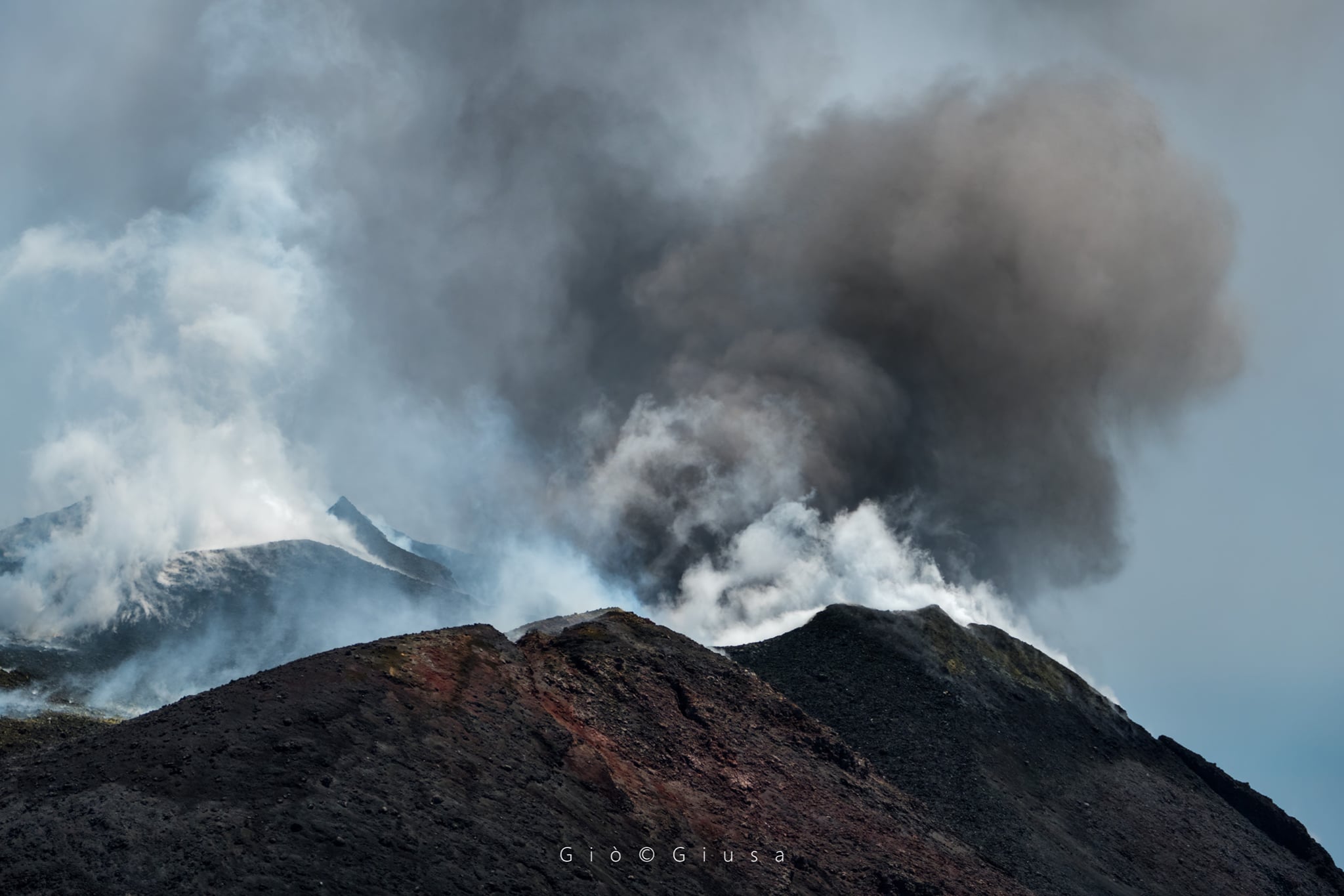
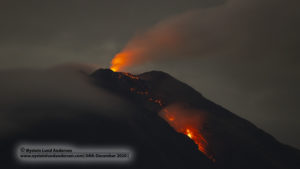
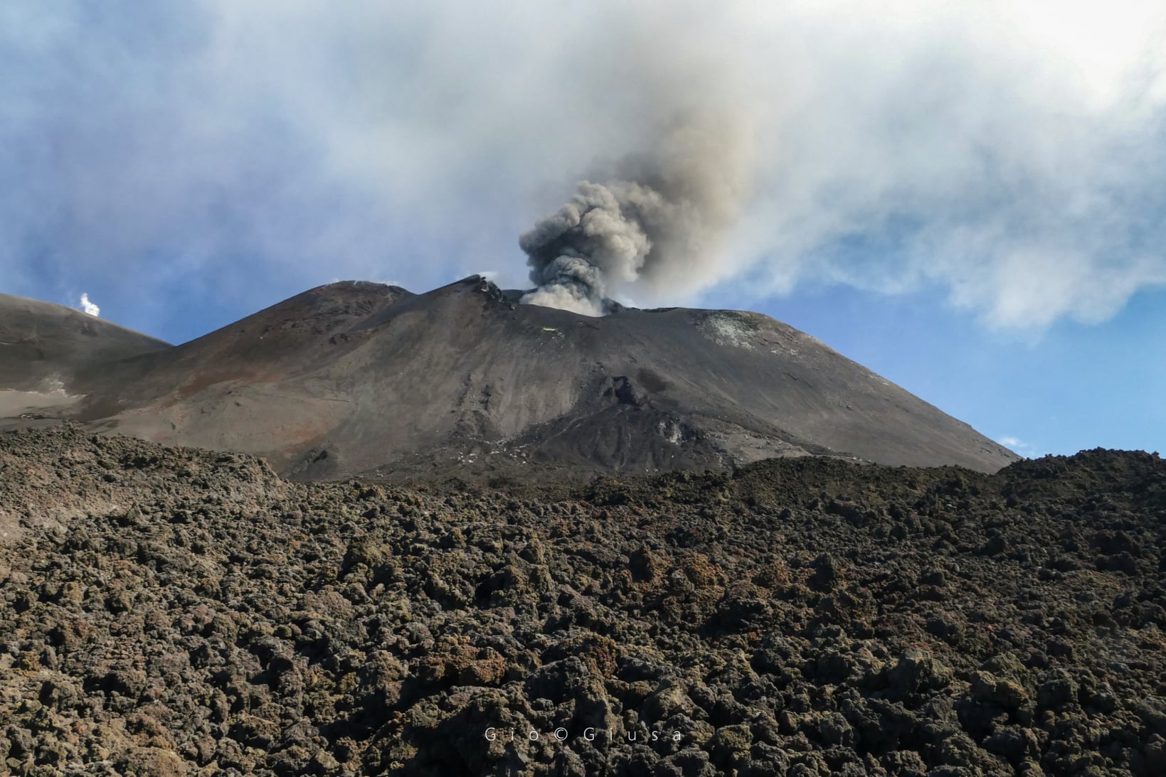
During the period considered, the activity of the summit craters of Etna was mainly characterized by Strombolian activity and discontinuous ash emissions at the New Southeast Crater (NSEC), by Strombolian activity at the Northeast crater ( NE), sporadic and light ash emissions at the Voragine crater (VOR), degassing activity at the Bocca Nuova (BN) crater.
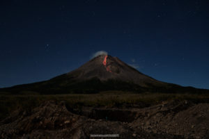
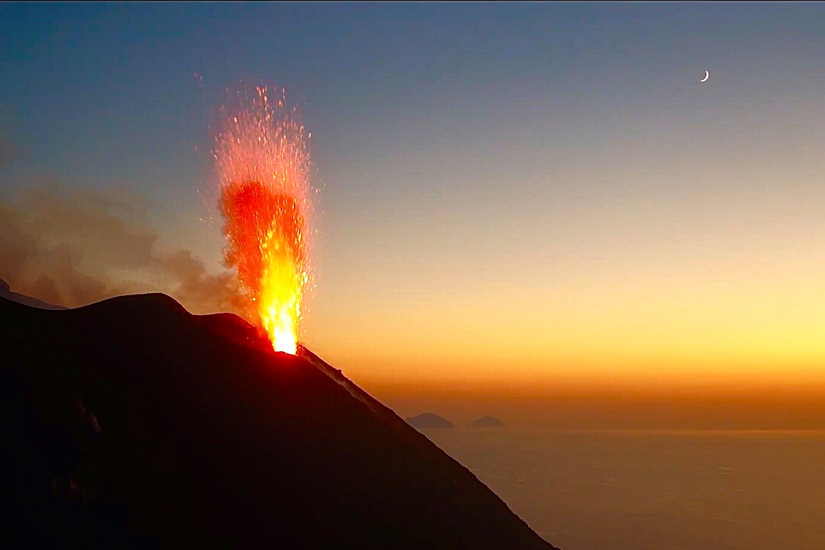
Strombolian activity « at the saddle cone » of the New Southeast Crater continued throughout the week. This activity was very variable and, during the most intense phases, the images of the surveillance cameras of the INGV-OE showed launches of eruptive products above the edge of the crater.
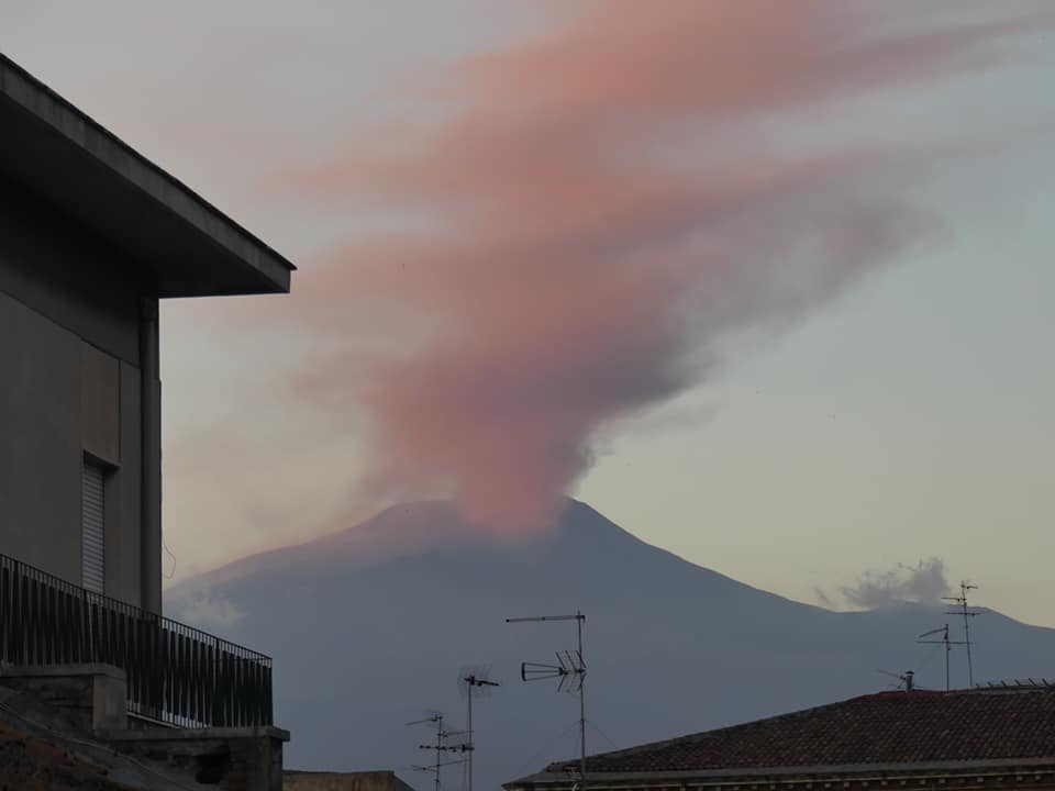
The activity was also characterized by discontinuous emissions of volcanic ash with the formation of generally dilute eruptive clouds that rapidly dispersed into the atmosphere. Between the afternoon of August 20 and the early hours of the morning of August 21, the emission of ash increased both in intensity and frequency, forming, as shown by surveillance cameras INGV-OE, a cloud volcanic 4.5 km high above sea level which dispersed to the South-South-East. INGV-OE staff detected the presence of a thin deposit of volcanic ash in Trecastagni, Viagrande and Catania. An increase in explosive activity also occurred on the morning of August 22. The volcanic cloud formed during this activity was about 4 km high and dispersed to the south.
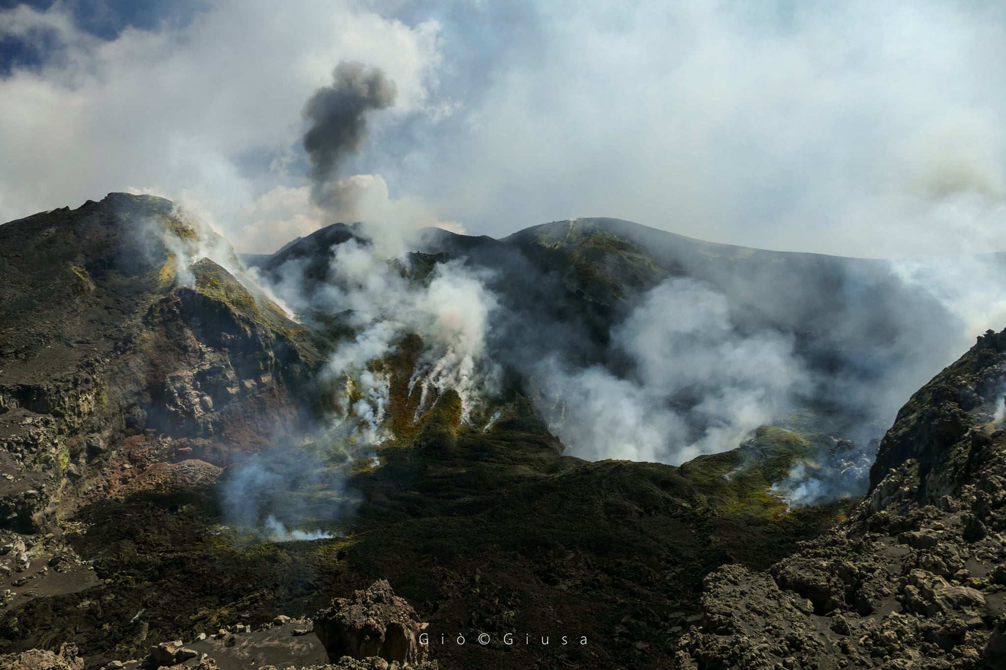
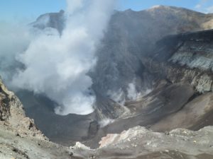
As observed by INGV-OE personnel present in the summit area on August 21, Strombolian activity continues at the Northeast Crater, with product launches that remain confined under the rim of the crater. The Voragine crater is characterized by degassing activity, as observed during inspections on August 17 and 21 by INGV-OE personnel, and by light and sporadic emissions of volcanic ash which rapidly disperse into the atmosphere. Rather, the Bocca Nuova was characterized by degassing activities.
Volcanic tremor:
The temporal evolution of the average amplitude of the volcanic tremor showed large fluctuations, mainly at an average level, throughout the week and, in a subordinate way, these oscillations reached a high level. The source of the tremor was constantly located in the area of the New Southeast Crater, at a depth of about 2900-3000 meters above mean sea level.
ETNA COMMUNICATION [UPDATE n. 71], 25 August 2020.
The National Institute of Geophysics and Volcanology, Osservatorio Etneo, announces that from around 3:30 p.m. GMT there has been a gradual increase in ash emissions at the New Southeast Crater which has formed a volcanic cloud of about 4.5 km above sea level, scattered to the south-east. The explosive activity is very variable in time and intensity. There was a modest fall of ash between the towns of Viagrande and Trecastagni.
As for the temporal trend of the mean amplitude of the volcanic tremor, it continues to present marked fluctuations which globally define a substantially stationary trend which is maintained mainly in the range of mean values. The location of the source of the tremor is located near the New Southeast Crater area, at a depth of about 2900-3000 meters above mean sea level. Regarding infrasound activity, In the last 12 hours, events have mainly taken place in the New Southeast Crater area
Soil deformation monitoring networks have not shown any significant changes over the past few hours.
Further updates will be communicated shortly.
Source : INGV.
Photos : Gio Giusa , Alessio Francesca Mangano .
Italy , Stromboli :
Weekly bulletin from August 17, 2020 to August 23, 2020 (issue date August 25, 2020)
SUMMARY OF THE STATE OF ACTIVITY
In the light of the surveillance data, it is highlighted:
1) VOLCANOLOGICAL OBSERVATIONS: Normal explosive volcanic activity of Strombolian type on a medium-low to medium level (9-15 events / h), and with an intensity from low to high in the area of the North crater and from medium to high in the Center -South zone.
2) SEISMOLOGY: The seismological parameters do not show significant variations.
4) DEFORMATIONS: The island soil deformation monitoring networks did not show significant variations over the period studied.
5) GEOCHEMISTRY: the flow of SO2 is at a medium-low level
There are no updates on the soil CO2 flux data.
There is no update for the CO2 / SO2 report (last measurement on 07/19/2020).
The isotopic values of Helium (last update 15/07/2020) are average values.
6) SATELLITE OBSERVATIONS: The thermal activity in the summit area is at a medium-low level.
VOLCANOLOGICAL OBSERVATIONS:
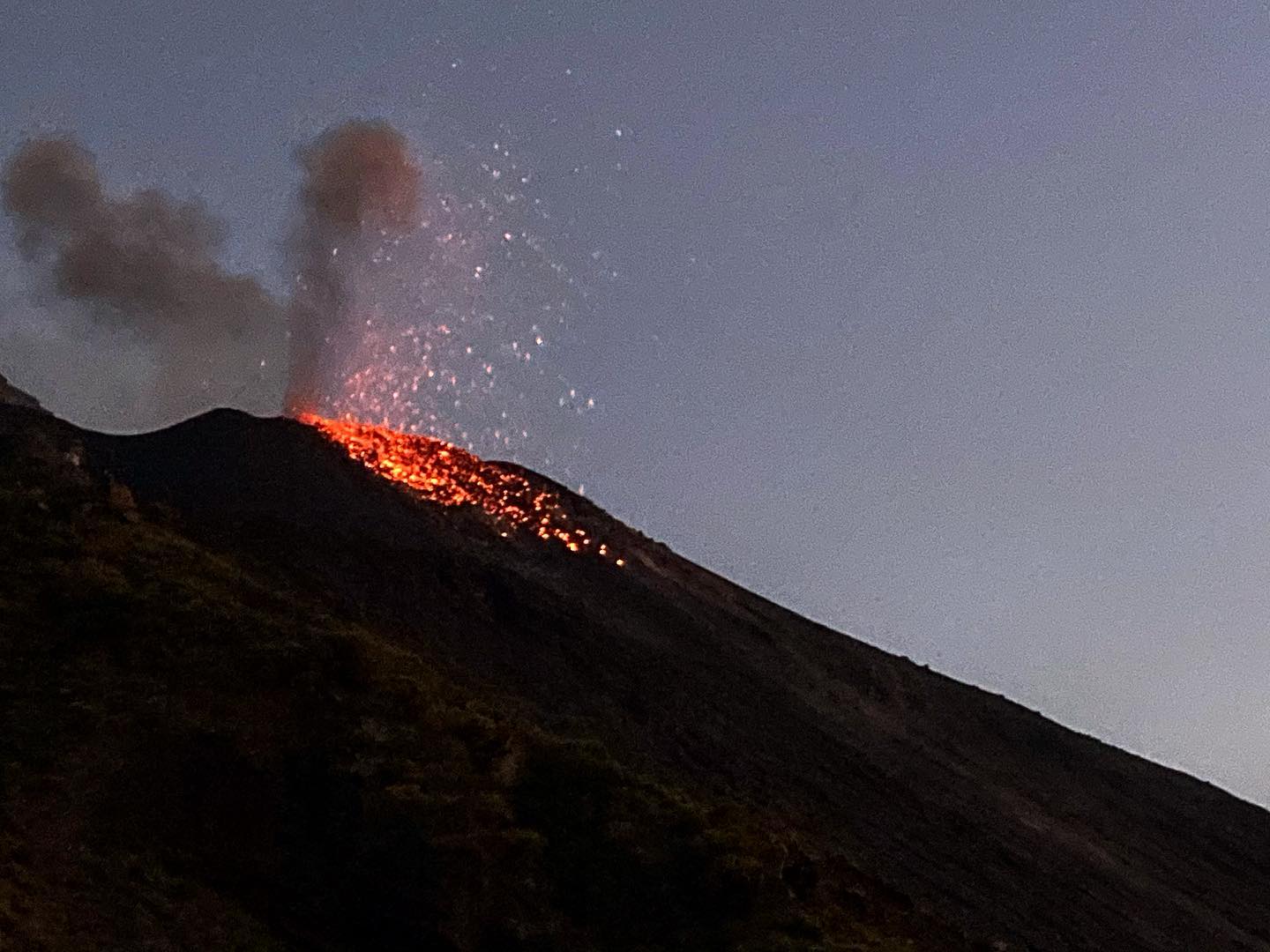
In the period under observation, the eruptive activity of Stromboli was characterized by the analysis of the images recorded by the surveillance cameras of the INGV-OE located at an altitude of 190 m, from Punta dei Corvi and an altitude of 400 m and by means of an inspection carried out on August 22 by INGV-OE staff. The Pizzo camera was damaged during the event of July 19, 2020 and the station is being restored in the INGV-OE laboratories.
The description of the activity and the determination of the vents that fuel the explosive activity in the individual areas of the North and Center-South craters could present uncertainties due to the framing of the cameras at an altitude of 400 m and an altitude of 190 m which do not make it possible to determine the emission points, in particular in the Center-South zone.
Referring to the observations made by INGV-OE staff during the inspection on August 22, the morpho-structural arrangement of the crater terrace consists of three eruptive vents located in the North crater area and at least three eruptive vents located in the South Center crater area. All the vents are placed inside the depression which occupies the terrace of the crater.
The area of the North crater produced explosions of low to high intensity, with the emission of mainly coarse materials (lapilli and bombs). Upon inspection, it was observed
that N1 has at least two vents, both located on the edge of the crater terrace leading to Sciara del Fuoco; the coarse material emitted by N1 also reaches heights above 200 m. The N2 vent consists of a cone with a large crater and showed low intensity explosive activity, with the emission of fine materials (ash) sometimes mixed with coarse materials. The average frequency of the explosions varied from 3 to 7 events / h. The coarse material emitted fell mainly in the terrace of the crater and in the upper sector of the Sciara del Fuoco, frequently rolling along the steep slope. In the area of the central-south crater, explosions of mainly fine materials were observed, sometimes mixed with coarser materials, with medium-high intensity (the products emitted often exceeded 250 m in height). In particular, during the inspection on August 22, it was possible to observe that S2 has two openings which mainly produce ash. S1 mouth, in contrast, showed no activity, while C had two mouths characterized by low emissions. The frequency of the explosions ranged from less than 1 to 11 events / h.
Source : INGV.
Photos : Webcam via Stromboli Adventures , Webcam.
Iceland , Reykjanes Peninsula :
Over 1300 earthquakes were detected by the IMO¿s SIL seismic network this week and around 1030 of them have been manually located. This is rather less activity than last week when around 1660 earthquakes were located. The biggest difference is a little less activity in the North and in Reykjanes peninsula. The activity in the North continues however, and around 790 earthquakes were located there this week.
The activity in Reykjanes also continues and around 300 earthquakes were located there this week. One of those earthquakes was felt in the Reykjavík area on 21. August, a M2.8 at 01:37 around 7 km SSE of Helgafell. A swarm of around 85 earthquakes occurred on 21. August around 30 km WNW of Kópasker. The largest earthquake of the sequence was M3.2 at 11:50. This was also the largest earthquake of the week. No reports the earthquake was felt in the surrounding area. One earthquake was detected in Grímsvötn this week and one by Hekla. Due to computer malfunction earthquake review has not been completed for the period 21 August at 23:30 to 22 August at 13:30.
Source : Vedur is
Photo : thorbjorn , Ómar Ragnarsson.
Colombia , Nevado del Ruiz :
Weekly activity bulletin of the Nevado del Ruiz volcano
The activity level continues at Yellow Activity Level or (III): changes in the behavior of volcanic activity.
Regarding the monitoring of the activity of the Nevado del Ruiz volcano, the COLOMBIAN GEOLOGICAL SERVICE reports that:
The seismicity generated by the fracturing of rocks (volcano-tectonics, VT) showed a significant increase in the number of earthquakes and the seismic energy released, compared to the previous week. This type of seismicity was located mainly in the South-South-East, South-West and North-East sectors of the volcano and, to a lesser extent, in the Arenas crater. The depth of the earthquakes varied between 0.3 and 5.6 km. An increase in VT-type seismicity stands out, recorded since dawn today in the south-eastern sector, about 2.2 km from the Arenas crater. The maximum magnitude recorded in the week corresponds to two earthquakes recorded during the aforementioned increase, occurring at 6:12 am and 7:57 am (local time), with a magnitude of 2.8 ML (local magnitude), at depths of 3.4 and 3.3 km respectively. These earthquakes were reported to be felt by the inhabitants of the volcanic area.
Seismicity related to fluid dynamics inside volcanic conduits maintained similar levels in the number of events and in the seismic energy released, compared to the previous week. This seismic activity was characterized by the appearance of continuous volcanic tremors, tremor pulses, earthquakes of long and very long period type, which presented variable energy levels and spectral content. This seismicity was localized around the Arenas crater.
Source : SGC.