August 04 , 2020.
Peru , Sabancaya :
Analysis period: July 20 to 26, 2020, Arequipa, July 27, 2020.
Alert level: ORANGE
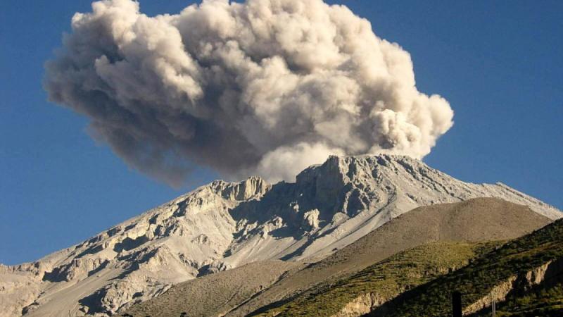
The Geophysical Institute of Peru (IGP) reports that the eruptive activity of the Sabancaya volcano remains at moderate levels; that is to say with the continuous recording of explosions with columns up to 2.4 km high above the summit of the volcano and consequent emissions of ash and gas. Therefore, for the following days, no significant change is expected in the eruptive activity.
The IGP recorded and analyzed the occurrence of around 400 earthquakes of volcanic origin, associated with the circulation of magmatic fluids (magma, gas, etc.) within the Sabancaya volcano (Arequipa region). In addition, an average of 13 low to medium intensity explosions was recorded daily.
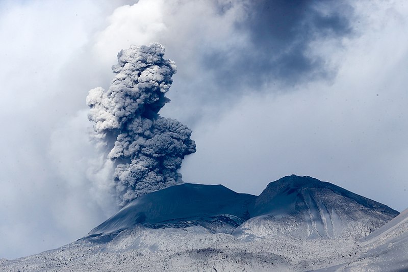
The monitoring of the deformation of the volcanic structure, using GNSS data (processed with fast orbits), does not present any significant anomalies; however, a slight inflation was recorded in the northern sector (Hualca Hualca volcano) and on the south-eastern flank of the Sabancaya volcano. Visual surveillance identified columns of gas and ash up to 2.6 km high above the summit of the volcano, which were scattered to the South, Southeast, Southwest and South. West of Sabancaya. Satellite monitoring has identified the presence of 5 thermal anomalies with values between 1 MW and 4 MW, associated with the presence of a lava body on the surface of the volcano crater.
RECOMMENDATIONS
• Maintain the volcanic alert level in orange.
• Do not approach within a radius of less than 12 km from the crater. If ash falls, cover your nose and mouth with wet rags or masks. Keep doors and windows of houses closed.
• Implement prevention and mitigation actions in the face of an increase in volcanic activity.
Source : IGP.
Photo : Galeria del Ministerio de Defensa del Perú
Peru , Ubinas :
Analysis period: July 20 to 26, 2020, Arequipa, July 27, 2020.
Alert level: ORANGE
The Peruvian Geophysical Institute (IGP) reports that the Ubinas volcano (Moquegua region) continues to record during the analysis period a slight increase in its seismic activity; therefore, it is suggested to the authorities and the population to keep an eye on the bulletins published by the IGP.
During the analysis period, the occurrence of 20 earthquakes with a magnitude less than M1.5 was identified, events associated with rock breaking processes that occur inside the volcano. On average, the occurrence of 3 earthquakes per day was recorded. Similarly, 6 seismic signals were recorded, associated with the movements of volcanic fluids (water vapor and gas. Among these, 2 « Tornillos » type events were identified, earthquakes linked to the increase of the internal pressure of the volcano There was no seismic activity linked to the rise of the magma.
Surveillance cameras recorded columns of gas and water vapor reaching heights of up to 700 m above the summit of the volcano. These emissions were dispersed towards the south-eastern sector of the volcano.
Monitoring of the deformation of the volcanic structure, using GNSS instruments, and satellite monitoring through the SENTINEL, IMO-NASA (SO2 gas) and MIROVA (thermal anomalies) systems did not record any anomalies at the during the analysis period.
RECOMMENDATIONS:
• Stay informed at all times of volcanic activity in the Ubinas thanks to the bulletins published by the IGP: (http://www.igp.gob.pe/servicios/centro-vulcanologico-nacional/).
• Do not approach within a radius of less than 3 km from the crater of the volcano.
• Do not neglect preventive actions in the event of a possible increase in volcanic activity.
Source et photo : IGP.
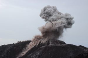
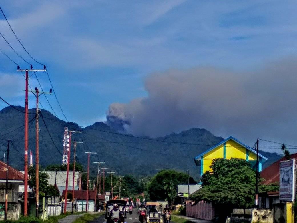
Indonesia , Dukono :
Level of activity at level II (WASPADA). The Dukono (1229 m above sea level) is experiencing a continuous eruption. The last eruption occurred on August 3, 2020, resulting in an eruption column height of 500 m. The color of the gray column was observed white / gray.
The volcanoe is clearly visible until it is covered in fog. Smoke from the crater is observed white / gray with strong intensity, rising about 200-500 meters above the summit. The weather is sunny / rainy, winds are light to moderate to the northeast and east.
According to the seismographs of August 3, 2020, it was recorded:
1 emission earthquake / eruption
Continuous tremor, amplitude 0.5-6 mm (dominant value 2 mm).
Recommendation:
The community around G. Dukono and visitors / tourists should not move, climb and approach the Malupang Warirang crater within a radius of 2 km.
Since volcanic ash eruptions occur periodically and the ash dispersion follows the direction and speed of the wind, as the ash is not fixed, it is recommended that the community around G. Ducono always wear a mask. / Nose cover for the mouth to be used when needed to avoid the threat of danger of volcanic ash in the respiratory system.
VOLCANO OBSERVATORY NOTICE FOR AVIATION – VONA.
Issued : August 04 , 2020
Volcano : Dukono (268010)
Current Aviation Colour Code : ORANGE
Previous Aviation Colour Code : orange
Source : Dukono Volcano Observatory
Notice Number : 2020DUK67
Volcano Location : N 01 deg 41 min 35 sec E 127 deg 53 min 38 sec
Area : North Maluku, Indonesia
Summit Elevation : 3933 FT (1229 M)
Volcanic Activity Summary :
Eruption with volcanic ash cloud at 23h02 UTC (08h02 local).
Volcanic Cloud Height :
Best estimate of ash-cloud top is around 5213 FT (1629 M) above sea level, may be higher than what can be observed clearly. Source of height data: ground observer.
Other Volcanic Cloud Information :
Ash-cloud moving to east.
Remarks :
Eruption and ash emission is continuing.
Source : Magma Indonésie , PVMBG.
Photos : Alex Djangu Trekker , Martin Rietze .
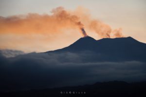
Italy , Campi Flegrei :
Weekly bulletin from July 21, 2020 to July 27, 2020
(Updated July 28, 2020 at 12:00 p.m. local time)
1. SUMMARY OF THE STATE OF THE ACTIVITY
In the light of surveillance data, it is highlighted:
1) SEISMOLOGY: During the last week, 19 low energy earthquakes were recorded in the Campi Flegrei region (Mdmax = 0.2).
2) DEFORMATIONS: The average value of the lifting speed in the maximum deformation zone, from January 2020, is approximately 6 mm / month. The ascent recorded at the RITE GPS station has been around 63 cm since January 2011.
3) GEOCHEMISTRY: Soil CO2 fluxes measured last week did not show significant changes after the drop in values recorded in early May, probably
linked to local variations of the emission site measured by the station. The temperature of the main fumarole of Pisciarelli showed an average value of about 115 ° C.
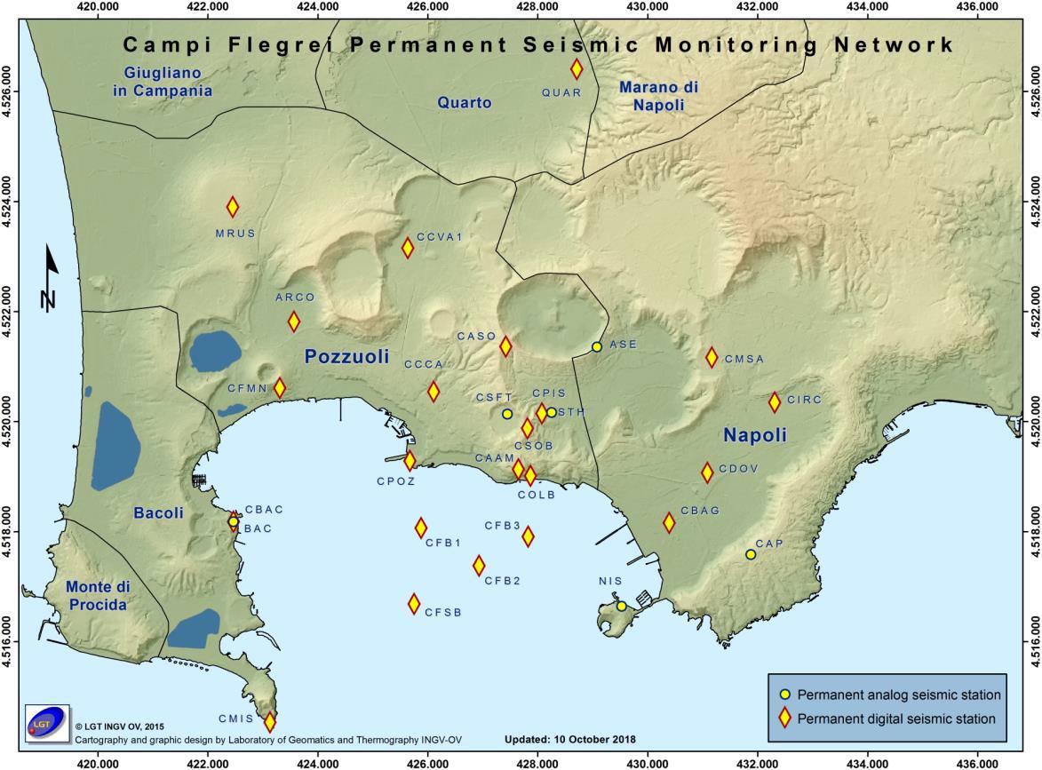
Seismicity:
During the last 7 days in the Campi Flegrei region, 19 low energy earthquakes were recorded with -1.1 ≤ Md ≤ 0.2.
It was possible to determine the hypocenter parameters of 5 of the recorded events,
Geochemistry:
The values of the flux of CO2 from the soil continuously recorded by the FLXOV8 station in the Pisciarelli area (north-eastern outer side of the Solfatara), highlight the persistence of the multi-year trends already identified previously (see monthly reports). Soil CO2 fluxes measured last week did not show any significant changes after the drop in values recorded in early May, probably linked to local variations in the emission site measured by the station.
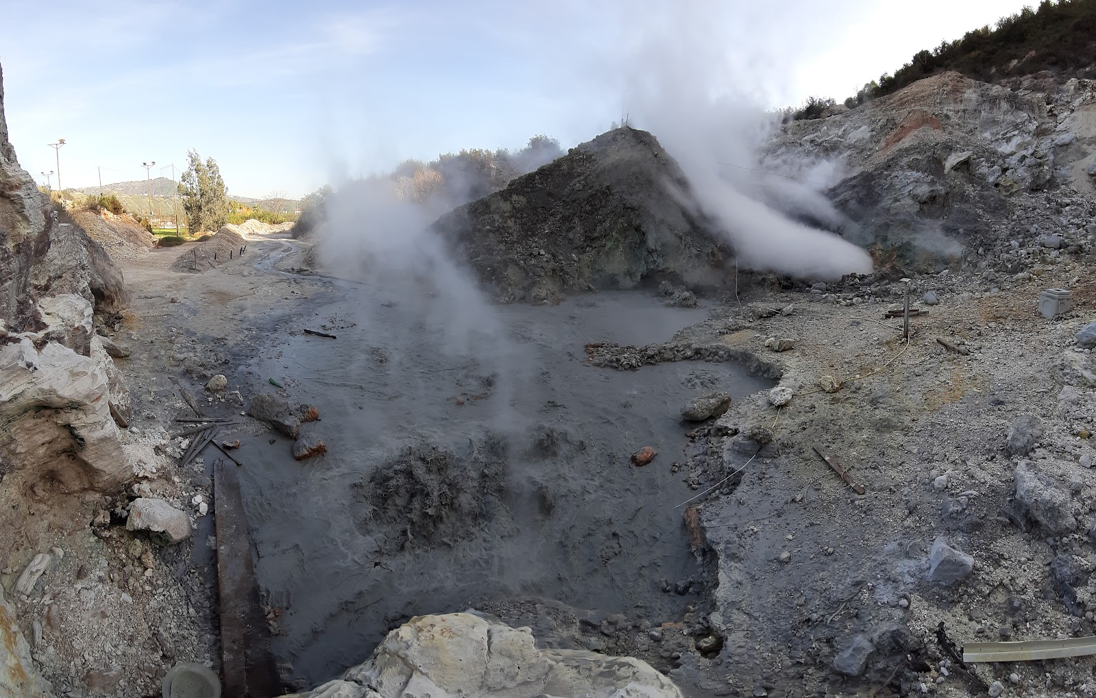
During the last week, the temperature of the main Pisciarelli fumarole recorded continuously showed an average value of ~ 115 ° C, in line with the values recorded in previous periods.
It should be noted that this fumarole being a constantly evolving natural system, with macroscopic variations of the emission site, the temperature recorded continuously may not always coincide with the maximum emission temperature.
Source : INGV.
Read the full article : http://www.ov.ingv.it/ov/bollettini-campi-flegrei/Bollettino_Flegrei_2020_07_28.pdf
Photos : INGV , Pisciarelli , Tullio Ricci, dicembre 2019
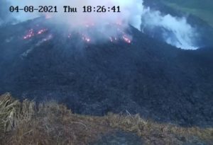
Mexico , Popocatepetl :
August 03, 11:00 a.m. (August 03, 4:00 p.m. GMT)
Over the past 24 hours, the Popocatépetl volcano monitoring system has identified 16 exhalations accompanied by volcanic gases and sometimes small amounts of ash. In addition, 1292 minutes of tremor were recorded, generating a constant emission of volcanic gases. It was also recorded yesterday at 1:57 p.m., a moderate explosion. Due to weather conditions, it was not possible to determine the height of the column.
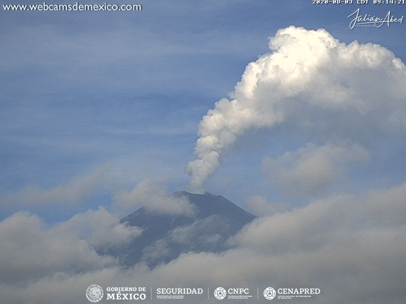
During the night, there was partial visibility of the volcano, however, an incandescence could be observed above the crater.
Today morning and at the time of this report, it was possible to observe a constant emission of gas, and small quantities of ash which disperse towards the North-West.
CENAPRED urges NOT TO APPROACH the volcano and especially the crater, because of the danger involved by the fall of ballistic fragments and, in the event of heavy rains, to move away from the bottom of the ravines because of the danger of mudslides and debris.
The Popocatépetl volcanic alert signal light is in YELLOW PHASE 2.
Source et photo : Cenapred.