May 04 , 2023.
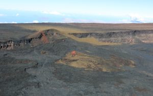
Philippines , Kanlaon :
This is a notice of increased volcanic SO2 gas flux at Kanlaon Volcano.
Volcanic sulfur dioxide (SO2) gas emission from the summit crater of Kanlaon based on campaign Flyspec measurements yesterday, 30 April 2023, averaged 1,099 tonnes/day, the highest value recorded this year. This is almost an order of magnitude higher than the average of 124 tonnes/day recorded since March 2023. In addition to this, real-time and continuous volcanic gas monitoring of thermal springs on the northern slopes detected for the first time volcanic SO2 concentrations beginning April 2023. The Kanlaon Volcano network recorded one hundred and forty-one (141) volcanic earthquakes between 1 April and 30 April 2023, for an average of five (5) per day. These earthquakes occurred at shallow depths to depths of 10 kilometers across the northern to western portions of the edifice. Ground deformation data from continuous GPS and electronic tilt measurements have been recording short-term inflation of the lower and middle slopes since March 2023 indicating slow pressurization within the volcano. These parameters could indicate increased hydrothermal activity occurring beneath the edifice, possibly driven by degassing of even deeper magma, with increased possibilities of phreatic or steam-driven explosions occurring at the summit crater.
The public is reminded that Alert Level 1 prevails over Kanlaon. The public and local government units are strongly advised to be vigilant and refrain from entering the four (4) kilometer Permanent Danger Zone (PDZ) due to increased chances of sudden and hazardous phreatic eruptions occurring without warning. Civil aviation authorities must also advise pilots to avoid flying close to the volcano’s summit as ejecta from any sudden phreatic eruption can be hazardous to aircraft. DOST-PHIVOLCS is closely monitoring Kanlaon Volcano’s activity and any new development will be relayed to all concerned.

PHIVOLCS issued a special notice for Kanlaon at 07h00 on 1 May, noting increased sulfur dioxide emissions. Real-time, continuous volcanic gas monitoring of thermal springs on the N flank detected sulfur dioxide for the first time beginning in April. On 30 April a Flyspec instrument measured an average of 1,099 tonnes per day of sulfur dioxide emissions at the summit crater, a value which was significantly higher than the average of 124 tonnes per day measured since March. During the month of April, the seismic network recorded 141 volcanic earthquakes, an average of five per day, at shallow depths less than 10 km in the N and W parts of the volcano. Ground deformation data from continuous GPS and electronic tilt data indicated short-term inflation of the lower and mid-flanks of the volcano since March. The Alert Level remained at 1 (on a scale of 0-5) and PHIVOLCS reminded the public to remain outside of the 4-km-radius Permanent Danger Zone.
Sources : Philippine Institute of Volcanology and Seismology (PHIVOLCS) , GVP
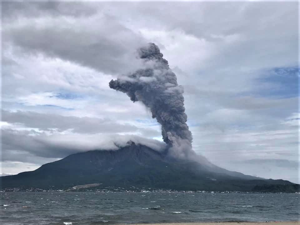
Photos: Bongbong Woo Tadifa , Phivolcs.
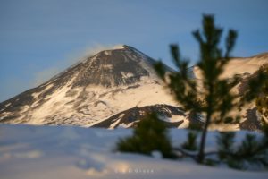
Vanuatu , Ambae :
On 27 April the Vanuatu Meteorology and Geo-Hazards Department (VMGD) reported that the cone in Ambae’s Lake Voui continued to produce emissions consisting of steam, volcanic gases, and ash. Volcanic earthquakes were recorded by the seismic network. Activity intensified during 5-7 April and was characterized by higher steam, gas, and ash plumes and nighttime incandescence from the growing cone.

Lava flows from the vent traveled N into a small water lake, filling it in. The Alert Level remained at 2 (on a scale of 0-5) and the public was warned to stay outside of the Danger Zone, defined as a 2-km radius around the active vents in Lake Voui, and away from drainages during heavy rains.
Sources : Département de la météorologie et des géorisques de Vanuatu (VMGD), Wellington Volcanic Ash Advisory Center (VAAC) , GVP
Photo : Volcan Ambae.
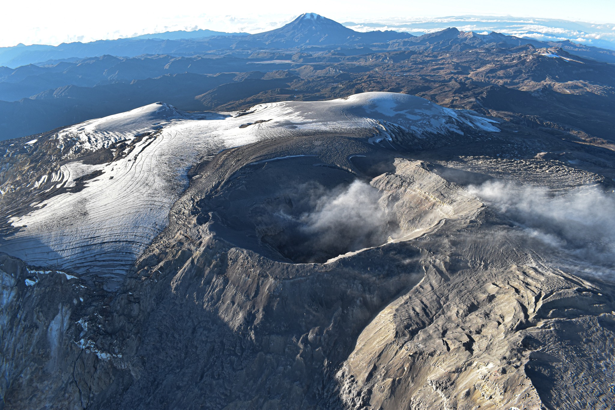
Colombia , Nevado del Ruiz :
Manizales, 03 May 2023 09:50
Regarding the monitoring of the activity of the NEVADO DEL RUIZ VOLCANO, the MINISTRY OF MINES AND ENERGY through the COLOMBIAN GEOLOGICAL SERVICE (SGC) informs that:
Yesterday May 2 and until today, the predominance of seismic activity related to the movement of fluids inside the volcanic conduits continues, which presents a similar behavior in terms of the number of earthquakes and a slight increase in seismic energy compared to the previous day (May 1). Some seismic signals associated with this type of seismicity have been associated with confirmed pulsating ash emissions through web cameras used for volcanic monitoring.
On May 2, the seismic activity associated with the fracturing of the rock inside the volcanic edifice showed a decrease in the number of earthquakes recorded and the seismic energy released, compared to the previous day. The seismicity was located mainly in the southeast and southwest sector of the volcano, at distances between 2 and 3 km from the Arenas crater, respectively.
The depths of the earthquakes ranged from 2 to 4 km. The maximum magnitude was 1.2, corresponding to the earthquake recorded at 12:01 a.m., located about 2 km southeast of the Arenas crater, and 4 km deep.
The degassing of sulfur dioxide in the atmosphere and the emission of water vapor from the crater continues. The maximum height of the column of gas and / or ash observed yesterday was 3000 m (in dispersion) measured from the summit of the volcano. Regarding the direction of dispersion of the column, it was variable between the North-West and the South-West of the volcano. Thermal anomalies are also still observed at the bottom of the crater; yesterday and up to 8:00 a.m. today, multiple reports were obtained from satellite monitoring platforms.
The level of activity of the volcano remains at the ORANGE LEVEL of activity or (II): PROBABLE ERUPTION IN TERM OF DAYS OR WEEKS
Source et photo : GVP.
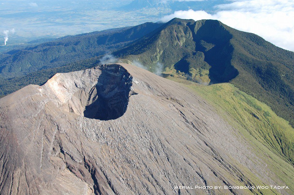
Japan , Sakurajima :
JMA reported ongoing eruptive activity at Minamidake Crater (at Aira Caldera’s Sakurajima volcano) during 24 April-2 May, with crater incandescence visible nightly. Very small eruptive events occasionally occurred during the week. On 28 April sulfur dioxide emissions were somewhat high at 1,800 tons per day. An explosion at 04h22 on 2 May ejected large blocks 500-700 m from the crater and generated an ash plume that rose 1.8 km above the crater rim and drifted SW. The Alert Level remained at 3 (on a 5-level scale), and residents were warned to stay 2 km away from both craters.
The Aira caldera in the northern half of Kagoshima Bay contains the post-caldera Sakurajima volcano, one of Japan’s most active. Eruption of the voluminous Ito pyroclastic flow accompanied formation of the 17 x 23 km caldera about 22,000 years ago. The smaller Wakamiko caldera was formed during the early Holocene in the NE corner of the Aira caldera, along with several post-caldera cones. The construction of Sakurajima began about 13,000 years ago on the southern rim of Aira caldera and built an island that was finally joined to the Osumi Peninsula during the major explosive and effusive eruption of 1914. Activity at the Kitadake summit cone ended about 4850 years ago, after which eruptions took place at Minamidake. Frequent historical eruptions, recorded since the 8th century, have deposited ash on Kagoshima, one of Kyushu’s largest cities, located across Kagoshima Bay only 8 km from the summit. The largest historical eruption took place during 1471-76.
Source : GVP , Agence météorologique japonaise (JMA)
Photo : Koki Arima.
Peru , Sabancaya :
Analysis period: from April 24, 2023 to May 01, 2023, Arequipa, May 02, 2023.
Alert level: ORANGE
The Geophysical Institute of Peru (IGP) reports that the eruptive activity of the Sabancaya volcano remains at moderate levels, that is to say with the recording of an average of 27 daily explosions, with columns of ash and of gas up to 2.1 km altitude above the summit of the volcano and their subsequent dispersion. Therefore, for the following days, no significant change is expected in eruptive activity.
The IGP recorded and analyzed the occurrence of 288 earthquakes of volcanic origin, associated with the circulation of magmatic fluids inside the Sabancaya volcano. An average of 27 explosions was recorded daily, in addition to recording Volcano-Tectonic (VT) type events associated with rock fracturing inside the Sabancaya volcano.
Monitoring the deformation of the volcanic structure using GNSS techniques (processed with fast orbits) does not show any significant anomalies. Visual surveillance identified columns of gas and ash up to 2.1 km above the summit of the volcano, which were dispersed towards the western, southwest and northwest sectors of Sabancaya . Satellite recordings have identified the presence of 7 thermal anomalies, with a maximum value of 15 MW, associated with the presence of a lava body on the surface of the crater of the volcano.
RECOMMENDATIONS
• Keep the volcanic alert level orange.
• Do not approach within a radius of less than 12 km from the crater.
Source : Cenvul
Photo : Ingemmet.