November 06 , 2022.
Ecuador , Reventador :
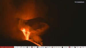
DAILY REPORT OF THE STATE OF THE REVENTADOR VOLCANO, Saturday November 05, 2022.
Information Geophysical Institute – EPN.
Surface Activity Level: Moderate, Surface Trend: No change
Internal activity level: Moderate, Internal trend: No change.
Seismicity: From November 04, 2022, 11:00 a.m. to November 05, 2022, 11:00 a.m.:
The seismic statistics were carried out at the REVS seismic station, which did not present any interruptions in the transmission of data.
Explosion (EXP): 27
Long Periods (LP): 55
Emission Tremors (TREMI): 11.
Rains / Lahars:
No rain was reported in the area in the past 24 hours.
Emission / ash column:
Three broadcast releases were recorded by the Washington VAAC, with heights of 688 meters above crater level in a NE direction. Emissions less than 1000 meters above summit level were also observed in a northeasterly direction.
Other Monitoring Parameters:
FIRMS registers 3 thermal alerts while MIROVA registers 2 moderate thermal alerts in the last 24 hours.
Observation:
At night, an incandescence was observed at the summit, while an emission was seen in the early morning.
Alert level: Orange.
Source : IGEPN.
Photos : Henry Vasconez
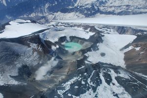
Colombia : Nevado del Ruiz ,
Bulletin of activity level of the Nevado del Ruiz volcano.
The activity level continues at the Yellow Activity Level or (III): changes in the behavior of volcanic activity.
Regarding the monitoring of the activity of the Nevado del Ruiz volcano, the COLOMBIAN GEOLOGICAL SERVICE reports that:
Seismic activity related to fluid dynamics inside volcanic conduits decreased in the number of earthquakes recorded and in the seismic energy released, compared to the previous week. Thanks to the images captured by the cameras installed in the volcano area, the gas and ash emissions associated with some of these seismic signals have been confirmed.
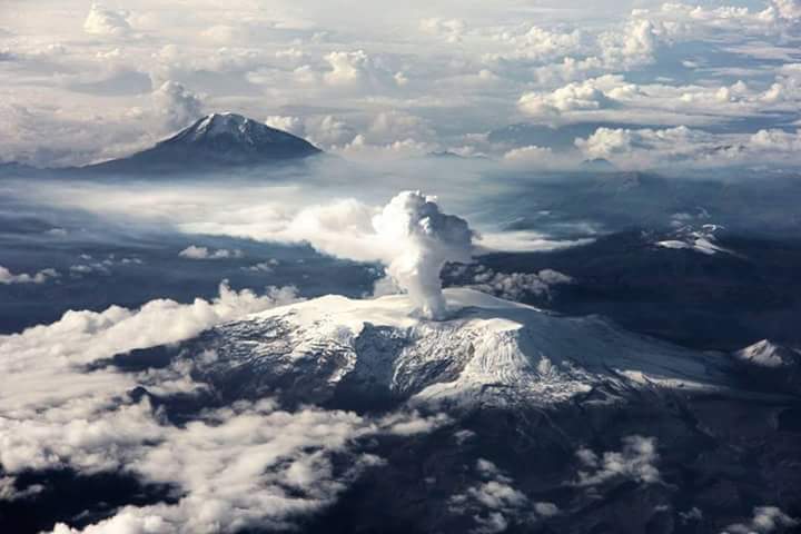
Seismic activity associated with rock fracturing decreased in the number of earthquakes recorded and increased in seismic energy released compared to the previous week. The earthquakes were located mainly in the Arenas crater, to the northeast and southwest of the crater and, in a scattered manner, in the eastern, southeast and northwest sectors of the volcano. The depth of the earthquakes ranged from about 0.2 to 7.0 km. The maximum magnitude observed during the week was 1.8 ML (Local Magnitude) corresponding to the earthquake recorded on October 28 at 05:18 (local time), located in the crater at a depth of 1.8 km.
During the week, seismicity related to the process of ascent, emplacement-growth and evolution of a lava dome at the bottom of Arenas crater continued to a lesser extent.
Deformation of the volcanic surface continues to show minor changes.
Source et photo : SGC
Hawaii , Mauna Loa :
19°28’30 » N 155°36’29 » W,
Summit Elevation 13681 ft (4170 m)
Current Volcano Alert Level: ADVISORY
Current Aviation Color Code: YELLOW
Activity Summary:
Mauna Loa is not erupting and there are no signs of an imminent eruption at this time. Monitoring data show no significant changes within the past 24 hours. Mauna Loa continues to be in a state of heightened unrest as indicated by increased earthquake activity and inflation of the summit. The current unrest is most likely being driven by renewed input of magma 2–5 miles (3–8 km) beneath Mauna Loa’s summit.
Observations:
During the past 24 hours, HVO detected 43 small-magnitude (below M3.0) earthquakes 2–3 miles (2–5 km) below Mokuʻāweoweo caldera and 4–5 miles (6–8 km) beneath the upper-elevation northwest flank of Mauna Loa. Both of these regions have historically been seismically active during periods of unrest on Mauna Loa. A M3.7 earthquake occurred northwest of the summit yesterday at 9:43 p.m.

The 1949 eruption of Mauna Loa began, and remained, within the summit region. However, the 1949 eruption did generate several small lava flows that traveled a few miles south, southeast, and southwest. The 1949 eruption lasted for approximately 144 days, and generated the cone pictured here, extending from above the southwest caldera wall to the caldera floor. Brown-colored cinders, deposited during the lava fountaining, built the cone, and can be seen blanketing the region surrounding the cone.
Global Positioning System (GPS) instruments at the summit and on the flanks of Mauna Loa continue to measure inflation at rates elevated since mid-September. However, tiltmeters at the summit are not showing significant surface deformation over the past week.
Concentrations of sulfur dioxide (SO2), hydrogen sulfide (H2S), and carbon dioxide (CO2), as well as fumarole temperatures, remain stable at the summit and at Sulphur Cone on the upper Southwest Rift Zone. Webcam and thermal camera views have shown no changes to the volcanic landscape on Mauna Loa over the past week.
Source : HVO
Photo : USGS / K. Mulliken.
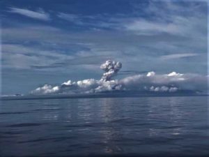
Alaska , Pavlof :
55°25’2″ N 161°53’37 » W,
Summit Elevation 8261 ft (2518 m)
Current Volcano Alert Level: WATCH
Current Aviation Color Code: ORANGE
Low-level eruptive activity continues from a vent on the east flank of Pavlof Volcano, just below the summit. Seismic tremor and small explosions were detected in geophysical data over the past day. Web camera and satellite views of the vent region were mostly obscured by clouds throughout the day, but a partly cloudy overnight satellite image showed elevated surface temperatures in the active vent.
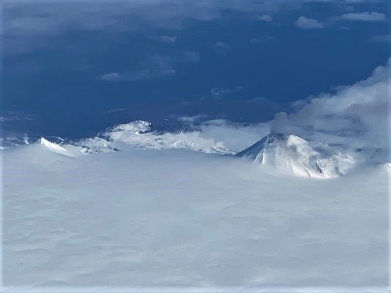
Small explosions associated with the current eruption could happen at any time and may be accompanied by small ash plumes within the immediate vicinity of the volcano. The level of unrest at Pavlof Volcano can change quickly and the progression to more significant eruptive activity can occur with little or no warning.
Pavlof Volcano is monitored by local seismic and infrasound sensors, satellite data, web cameras, and regional infrasound and lightning networks.
Source : AVO.
Photo : Ferguson-Gould, Tara / Alaska Volcano Observatory / University of Alaska Fairbanks, Geophysical Institute.
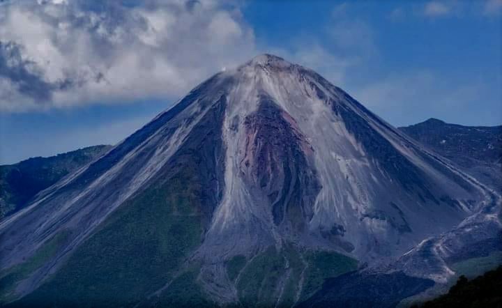
Guatemala , Santiaguito :
LAHAR IN THE CABELLO DE ÁNGEL RIVER, TRIBUTARY OF THE NIMÁ I RIVER
Heavy rainfall on the Santa María-Santiaguito volcanic complex is currently generating the descent of lahars into the Cabello de Ángel river, a tributary of the Nimá I and Samalá rivers, to the south-southwest of the volcano.
This lahar is weak to moderate in character, carrying a pasty mixture of water, boulders up to 1 meter in diameter, and finer sediments, as well as tree trunks and branches.
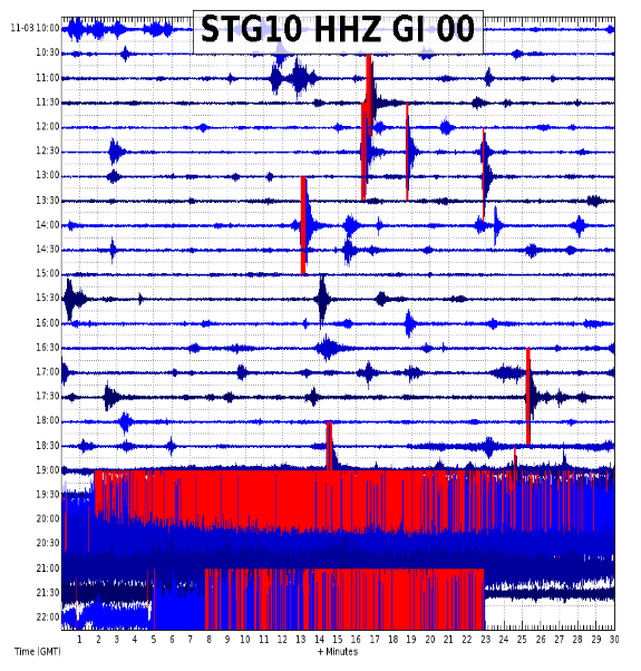
The lahar on its way produces vibrations in the ground which are recorded in the seismic stations close to the bed of the river, in this case the STG10. The lahar may increase its intensity in the next few minutes and, if these rainy conditions persist in the region, the possibility of lahars descending in one of the channels that descend from the volcanic complex is not excluded.
INSIVUMEH maintains visual and instrumental monitoring of volcanic activity through its field observers, seismic stations and web cameras.
Source : Insivumeh .