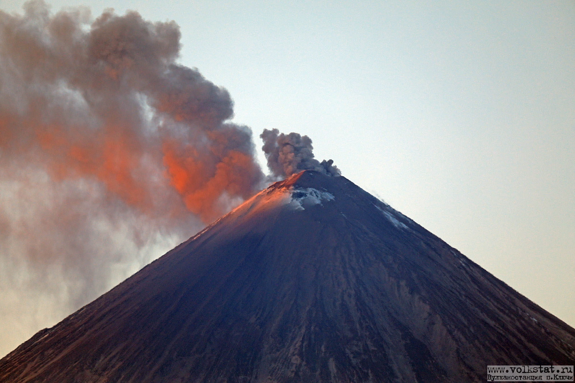
November 21, 2022. EN. Kamchatka : Klyuchevskoy , El Salvador : San Miguel (Chaparrastique) , Alaska : Takawangha , Indonesia : Semeru , Ecuador : Reventador .

November 21 ,  2022.


Kamchatka , Klyuchevskoy :

VOLCANO OBSERVATORY NOTICE FOR AVIATION (VONA)

Issued: November 20 , 2022
Volcano: Klyuchevskoy (CAVW #300260)
Current aviation colour code: YELLOW
Previous aviation colour code: green
Source: KVERT
Notice Number: 2022-178
Volcano Location: N 56 deg 3 min E 160 deg 38 min
Area: Kamchatka, Russia
Summit Elevation: 4750 m (15580 ft)

Volcanic Activity Summary:
According to the video data by KVERT, the Strombolian type of an explosive eruption of Klyuchevskoy volcano began to observing from 11:30 UTC on 17 November, 2022, and such activity continues. The appearance of a new thermal anomaly over the volcano was noted on 13 November, and the temperature of the thermal anomaly began increasing from 17 November, and this continues. The strong gas-steam plume is extending to the southeast of the volcano at now.

KVERT continues to monitor the Klyuchevskoy volcano.
A moderate explosive eruption of the volcano continues. Ash explosions up to 5-6 km (16,400-19,700 ft) a.s.l. could occur at any time. Ongoing activity could affect low-flying aircraft.

Volcanic cloud height: NO ASH CLOUD PRODUSED
Other volcanic cloud information: NO ASH CLOUD PRODUSED

Source : Kvert.

Photo : Volkstat ru.


El Salvador , San Miguel ( Chaparrastique) :

Special Report No. 5
WARNING. As intermittent explosions and outgassing continue in the San Miguel Volcano, it is called upon to be vigilant and not to carry out activities in the vicinity of its central crater.

Date and time of broadcast: November 20, 2022, 11:00:00.
The San Miguel volcano continues to record intermittent explosions, gas and water vapor emanations, with the probability of generating interruptions in the activities carried out near its crater.

According to the follow-up of the seismicity, the gas concentration and the characteristics of the ash collected, this activity will continue during the following days. Therefore, it is called to PAY ATTENTION mainly to residents of the municipalities of San Jorge, Chinameca, San Rafael Oriente and sectors near the volcano in the municipality of San Miguel.

Since Tuesday, November 15, the San Miguel volcano, through its central crater, has exhibited intermittent explosions, accompanied by gas, ash and abundant water vapor. The total number of explosions recorded is 62 to date, with a daily average of 10. The average height reached by the explosions was around 500 meters. However, the highest explosions, around 1100 meters, occurred on Friday the 18th at 1:36 p.m.; and Saturday 19 at 12:06 p.m.

Seismicity:
Variations in seismicity recorded by the Volcanic Station of San Miguel (VSM) indicate that currently the count of daily earthquakes retains its typical behavior; no intensification is observed in its internal processes.

Figure 1. Seismic recording of the VSM station.

Due to its historical records, the San Miguel volcano is characterized by this type of activity, classified as Strombolian and characterized by explosions, generally not very violent, accompanied by hot mixtures of gas, ash and rock fragments.

Source et photos : Marn


Alaska , Takawangha :

51°52’1″ N 178°1’37 » W,
Summit Elevation 4754 ft (1449 m)
Current Volcano Alert Level: ADVISORY
Current Aviation Color Code: YELLOW

Panorama of Takawangha volcano, Tanaga Island, as seen from the west.

The ongoing earthquake swarm near Takawangha volcano waxed and waned in intensity over the past day. The earthquakes are generally shallow, having preliminary depths of about 2 to 4 miles (3 to 6 km) below sea level. This activity may be due to the movement of magma beneath the volcano. No eruptive activity has been detected in satellite views or other monitoring data.

Source : AVO.

Photo : Coombs, M. L.


Indonesia , Semeru :

Mount Semeru erupted on Monday, November 21, 2022 at 06:08 WIB with the height of the ash column observed at ± 400 m above the summit (± 4076 m above sea level). The ash column was observed to be white / gray with moderate intensity, oriented northeast. This eruption was recorded on a seismograph with a maximum amplitude of 22 mm and a duration of 64 seconds.

VOLCANO OBSERVATORY NOTICE FOR AVIATION – VONA

Issued : November 20 , 2022
Volcano : Semeru (263300)
Current Aviation Colour Code : ORANGE
Previous Aviation Colour Code : orange
Source : Semeru Volcano Observatory
Notice Number : 2022SMR697
Volcano Location : S 08 deg 06 min 29 sec E 112 deg 55 min 12 sec
Area : East java, Indonesia
Summit Elevation : 11763 FT (3676 M)

Volcanic Activity Summary :
Eruption with volcanic ash cloud at 23h08 UTC (06h08 local).

Volcanic Cloud Height :
Best estimate of ash-cloud top is around 13043 FT (4076 M) above sea level or 1280 FT (400 M) above summit. May be higher than what can be observed clearly. Source of height data: ground observer.

Other Volcanic Cloud Information :
Ash cloud moving to east. Volcanic ash is observed to be white to gray. The intensity of volcanic ash is observed to be medium.

Remarks :
Eruption recorded on seismogram with maximum amplitude 22 mm and maximum duration 64 second. –

SEISMICITY OBSERVATION
18 earthquakes of eruptions / explosions with an amplitude of 10 to 22 mm and a duration of 41 to 118 seconds.
1 distant tectonic earthquake with an amplitude of 30 mm, S-P 17 seconds and a duration of 88 seconds.

Source et photo : Magma Indonésie.


Ecuador , Reventador :

DAILY REPORT OF THE STATE OF THE REVENTADOR VOLCANO, Sunday November 20, 2022.
Information Geophysical Institute – EPN.

Surface Activity Level: Moderate, Surface Trend: No change
Internal activity level: Moderate, Internal trend: No change.

Lava flow on the northeast flank. Rebecca thermal camera. 11/19/2022 Time: 11:08 p.m. UT.

Seismicity: From November 19, 2022, 11:00 a.m. to November 20, 2022, 11:00 a.m.:

The reference seismic station has been transmitting data normally for the past 24 hours. The level of recorded seismic activity remains moderate.

Explosion (EXP): 36
Long Periods (LP): 52
Emission Tremors (TREMI): 9.

Rains / Lahars:
Yesterday afternoon there were rains in the area which did not generate lahars.

Emission / Ash Column:
Most of the time the volcano remained cloudy. Washington VAAC reported 4 emissions from 988 meters snc in a northwesterly direction.


Other Monitoring Parameters:
Neither FIRMS nor MIROVA have recorded thermal alerts in the last 24 hours.

Gas:
The MOUNTS system reported 2032.5 tons of SO2, measured on 11/19/2022 at 12:56 TL

Observation:
Using the thermal camera, a lava flow is observed descending the northeast flank. For the moment, the volcano remains cloudy.

Alert level: Orange.

Source : IGEPN.

Photos : IGEPN


21 Novembre 2022. FR. Kamchatka : Klyuchevskoy , El Salvador : San Miguel ( Chaparrastique) , Alaska : Takawangha , Indonésie : Semeru , Equateur : Reventador .

21 Novembre 2022.


Kamchatka , Klyuchevskoy :

AVIS D’OBSERVATION DU VOLCAN POUR L’AVIATION (VONA)

Publié : 20 novembre 2022
Volcan : Klyuchevskoy (CAVW #300260)
Code couleur aviation actuel : JAUNE
Code couleur aviation précédent : vert
Source : KVERT
Numéro d’avis : 2022-178
Emplacement du volcan : N 56 degrés 3 min E 160 degrés 38 min
Région : Kamtchatka, Russie
Altitude du sommet : 4 750 m (15 580 pi)

Résumé de l’activité volcanique :
Selon les données vidéo du KVERT, une éruption explosive de type strombolienne du volcan Klyuchevskoy a commencé à être observé à partir de 11h30 UTC le 17 novembre 2022, et cette activité se poursuit. L’apparition d’une nouvelle anomalie thermique sur le volcan a été notée le 13 novembre, et la température de l’anomalie thermique a commencé à augmenter à partir du 17 novembre, et cela continue. Le fort panache de gaz et de vapeur s’étend actuellement au Sud-Est du volcan.

Le KVERT continue de surveiller le volcan Klyuchevskoy.
Une éruption explosive modérée du volcan se poursuit. Des explosions de cendres jusqu’à 5-6 km (16 400-19 700 pieds) d’altitude pourraient survenir à tout moment. L’activité en cours pourrait affecter les aéronefs volant à basse altitude.

Hauteur des nuages ​​volcaniques : AUCUN NUAGE DE CENDRES PRODUIT
Autres informations sur les nuages ​​volcaniques : AUCUN NUAGE DE CENDRES PRODUIT

Source : Kvert.

Photo : Volkstat ru.


El Salvador , San Miguel ( Chaparrastique) :

Rapport spécial n° 5
ATTENTION. Alors que les explosions intermittentes et le dégazage se poursuivent dans le volcan San Miguel, il est appelé à être vigilant et à ne pas mener d’activités dans les environs de son cratère central.

Date et heure de diffusion : 20 Novembre 2022 ,11:00:00 .
Le volcan San Miguel continue d’enregistrer des explosions intermittentes, des émanations de gaz et de vapeur d’eau, avec la probabilité de générer des interruptions dans les activités menées à proximité de son cratère.

Selon le suivi de la sismicité, de la concentration en gaz et des caractéristiques des cendres collectées, cette activité se poursuivra au cours des jours suivants. Par conséquent, il est appelé à FAIRE ATTENTION principalement aux résidents des municipalités de San Jorge, Chinameca, San Rafael Oriente et des secteurs proches du volcan dans la municipalité de San Miguel.

Depuis le mardi 15 novembre, le volcan San Miguel, à travers son cratère central, présente des explosions intermittentes, accompagnées de gaz, de cendres et de vapeur d’eau abondante. Le nombre total d’explosions enregistrées est de 62 à ce jour, avec une moyenne quotidienne de 10. La hauteur moyenne atteinte par les explosions a été d’environ 500 mètres. Cependant, les explosions les plus élevées, environ 1100 mètres, ont eu lieu le vendredi 18 à 13h36; et samedi 19 à 12h06. 

Sismicité :
Les variations de la sismicité enregistrées par la station volcanique de San Miguel (VSM) indiquent qu’actuellement, le décompte des tremblements de terre quotidiens conserve son comportement typique ; aucune intensification n’est observée dans ses processus internes.

Figure 1. Enregistrement sismique de la station VSM.

En raison de ses archives historiques, le volcan San Miguel se caractérise par ce type d’activité, classée comme strombolienne et caractérisée par des explosions, généralement peu violentes, accompagnées de mélanges chauds de gaz, de cendres et de fragments de roche.

Source et photos : Marn


Alaska , Takawangha :

51°52’1″ N 178°1’37 » O,
Altitude du sommet : 4754 pieds (1449 m)
Niveau d’alerte volcanique actuel : AVIS
Code couleur actuel de l’aviation : JAUNE

Vue panoramique du volcan Takawangha, île de Tanaga, vue de l’Ouest.

L’essaim de tremblements de terre en cours près du volcan Takawangha a augmenté et diminué en intensité au cours de la dernière journée. Les tremblements de terre sont généralement peu profonds, avec des profondeurs préliminaires d’environ 2 à 4 miles (3 à 6 km) sous le niveau de la mer. Cette activité peut être due au mouvement du magma sous le volcan. Aucune activité éruptive n’a été détectée dans les vues satellites ou d’autres données de surveillance.

Source : AVO.

Photo : Coombs, M. L.


Indonésie , Semeru :

Le mont Semeru a présenté une éruption le lundi 21 novembre 2022 à 06h08 WIB avec la hauteur de la colonne de cendres observée à ± 400 m au-dessus du sommet (± 4076 m au-dessus du niveau de la mer). La colonne de cendres a été observée comme étant blanche / grise avec une intensité modérée , orientée au Nord-Est. Cette éruption a été enregistrée sur un sismographe avec une amplitude maximale de 22 mm et une durée de 64 secondes.

AVIS D’OBSERVATION DU VOLCAN POUR L’AVIATION – VONA

Émis : 20 novembre 2022
Volcan : Semeru (263300)
Code Couleur Aviation Actuel : ORANGE
Code Couleur Aviation précédent : orange
Source : Observatoire du volcan Semeru
Numéro d’avis : 2022SMR697
Emplacement du volcan : S 08 deg 06 min 29 sec E 112 deg 55 min 12 sec
Région : Java oriental, Indonésie
Altitude du sommet : 11763 FT (3676 M).

Résumé de l’activité volcanique :
Eruption avec nuage de cendres volcaniques à 23h08 UTC (06h08 locale).

Hauteur des nuages volcaniques :
La meilleure estimation du sommet du nuage de cendres est d’environ 13043 FT (4076 M) au-dessus du niveau de la mer ou 1280 FT (400 M) au-dessus du sommet. Peut-être plus élevé que ce qui peut être observé clairement. Source des données de hauteur : observateur au sol.

Autres informations sur les nuages volcaniques :
Nuage de cendres se déplaçant vers l’Est. On observe que les cendres volcaniques sont blanches / grises. On observe que l’intensité des cendres volcaniques est moyenne.

Remarques :
Eruption enregistrée sur sismogramme avec une amplitude maximale de 22 mm et une durée maximale de 64 secondes. 

OBSERVATION DE LA SISMICITE
18 séismes d’éruptions / explosions d’une amplitude de 10 à 22 mm et d’une durée de 41 à 118 secondes.
1 tremblement de terre tectonique lointain d’une amplitude de 30 mm, S-P 17 secondes et d’une durée de 88 secondes.

Source et photo : Magma Indonésie.


Equateur , Reventador :

RAPPORT QUOTIDIEN DE L’ETAT DU VOLCAN REVENTADOR , Dimanche 20 Novembre 2022.
Information Geophysical Institute – EPN.

Niveau d’activité Superficiel: Modéré , Tendance de surface : Pas de changement
Niveau d’activité interne: Modéré , Tendance interne : Pas de changement .

Coulée de lave sur le flanc Nord-Est. Caméra thermique Rebecca. 19/11/2022 Heure : 23h08 TU.

Sismicité : Du 19 Novembre 2022 , 11:00h au 20 Novembre 2022 , 11:00h : 

La station sismique de référence a transmis des données normalement au cours des dernières 24 heures. Le niveau d’activité sismique enregistrée reste modéré.

Explosion (EXP) : 36
Longues périodes (LP) : 52
Tremors d’émissions (TREMI ) : 9.

Pluies / Lahars :
Hier après-midi il y a eu des pluies dans le secteur qui n’ont pas généré de lahars.

Colonne d’émission / cendres :
La plupart du temps, le volcan est resté nuageux. Le VAAC de Washington a signalé 4 émissions à partir de 988 mètres snc dans une direction Nord-Ouest.


Autres paramètres de surveillance :
Ni FIRMS ni MIROVA n’ont enregistré d’alertes thermiques au cours des dernières 24 heures.

Gaz:
Le système MOUNTS a rapporté 2032,5 tonnes de SO2, mesuré le 19/11/2022 à 12h56 TL

Observation:
A l’aide de la caméra thermique, une coulée de lave est observée descendant le flanc Nord-Est. Pour le moment, le volcan reste nuageux.

Niveau d’alerte: Orange.

Source : IGEPN.

Photos : IGEPN