March 15 , 2024.
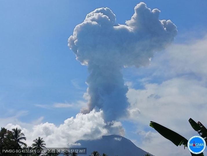
Indonesia , Ibu :
An eruption of Mount Ibu occurred on Friday March 15, 2024 at 00:13 WIT with the height of the ash column observed at ±800 m above the summit (±2,125 m above sea level). The ash column was gray in color with a thick intensity, oriented towards the Northeast. This eruption was recorded on a seismograph with a maximum amplitude of 26 mm and a duration of 174 seconds.
SEISMICITY OBSERVATIONS
6 eruption/explosion earthquakes with an amplitude of 15 to 28 mm and a seismic duration of 23 to 59 seconds.
121 emission earthquakes with an amplitude of 2 to 14 mm and earthquake duration of 15 to 50 seconds.
3 Tremor Harmonic with an amplitude of 3 to 6 mm and an earthquake duration of 52 to 325 seconds.
167 shallow volcanic earthquakes with an amplitude of 2 to 14 mm and a duration of 4 to 14 seconds.
6 deep volcanic earthquakes with an amplitude of 3 to 23 mm, and an earthquake duration of 5 to 10 seconds.
6 distant tectonic earthquakes with an amplitude of 3 to 23 mm, the duration of the earthquake was 29 to 113 seconds.
Recommendation
1. Communities around Mount Ibu and visitors/tourists should not practice activities within a radius of 2.0 km and a sectoral extension of 3.5 km towards the crater opening in the northern part of the active crater from Mount Ibu.
2. In the event of falling ash, people who carry out activities outside the home are advised to wear nasal, oral (mask) and eye (glasses) protection.
Source : Magma Indonésie .
Photo : PVMBG ( archive).
Chile , Tupungatito :
Seismology
The seismological activity of the period was characterized by the recording of:
107 seismic events of type VT, associated with the fracturing of rocks (Volcano-Tectonics). The most energetic earthquake had a local magnitude (ML) value of 2.6, located 9.1 km north-northwest of the volcanic edifice, at a depth of 6.6 km from the crater. .
67 LP type seismic events, associated with fluid dynamics inside the volcanic system (Long Period). The size of the largest earthquake evaluated from the Reduced Displacement (RD) parameter was equal to 9 cm2.
Fluid geochemistry
No anomalies have been reported in the emissions of sulfur dioxide (SO2) into the atmosphere in the area near the volcano, according to data published by the Tropopheric Monitoring Instrument (TROPOMI) and the Ozone Monitoring Instrument (OMI) Sulfur Dioxide Group.
Satellite thermal anomalies
During the period, no thermal alerts were recorded in the area associated with the volcano, according to the analytical processing of Sentinel 2-L2A satellite images, in combination of false color bands.
Surveillance cameras
The images provided by the fixed camera, installed near the volcano, did not record degassing columns or variations linked to surface activity.
Activity remained at levels considered low, suggesting stability of the volcanic system. The technical volcanic alert is maintained in:
GREEN TECHNICAL ALERT: Active volcano with stable behavior – There is no immediate risk.
Source et photo : Sernageomin
Colombia , Nevado del Ruiz :
Weekly bulletin on the activity of the Nevado del Ruiz volcano
Regarding the monitoring of the activity of the NEVADO DEL RUIZ VOLCANO, the MINISTRY OF MINES AND ENERGY, through the COLOMBIAN GEOLOGICAL SERVICE (SGC), reports that:
In the week of March 5-11, 2024, the volcano continued with unstable behavior. Compared to the previous week, the main variations in the parameters monitored were:
– Seismic activity associated with the fracturing of rocks within the volcanic edifice has increased in the number of earthquakes recorded and the seismic energy released. The earthquakes were located in the Arenas crater and on the northwest, south-southwest and northeast flanks of the volcano, mainly at distances less than 6 km from the crater. On the northwest flank, certain earthquakes were located at distances between 10 and 13 km from the crater. The depths of the events varied between less than 1 and 10 km from the volcano summit. The highest magnitude of the week was 1.8, corresponding to the March 7 earthquake at 11:08 a.m. mr. and located approximately 4 km south-southwest of the crater and 4 km deep. Low energy seismicity was also recorded linked to the activity of the lava dome (protrusion or mound) located at the bottom of the crater.

– Seismicity linked to fluid dynamics inside volcanic conduits has decreased in the number of earthquakes recorded and in the seismic energy released. Most seismic signals were associated with pulsatile emissions of ash and gas into the atmosphere. Energy levels were low to moderate. Several ash emissions have been confirmed by the cameras used to monitor the volcano, as well as some changes in the temperature of the emitted material associated with some of these seismic signals.
– The emission of water vapor and gas into the atmosphere continued at the volcano. Sulfur dioxide (SO2) outgassing rates were variable and increased. The maximum height of the gas or ash column was 1,100 m vertically and 2,000 m dispersed. These values were measured at the summit of the volcano on March 9 during the emission of ash recorded at 5:40 a.m. The direction of dispersion of the column was variable towards all the flanks of the volcano.
– When monitoring surface activity from satellite monitoring platforms, several thermal anomalies were detected at the bottom of Arenas Crater with low to moderate energy levels.
Source et photo : SGC
Ecuador / Galapagos Islands , Fernandina :
DAILY REPORT ON THE ACTIVITY OF THE FERNANDINA VOLCANO. Quito, Thursday March 14, 2024.
From March 13, 2024 11:00:00 to March 14, 2024 11:00:00
Activity level:
Surface: Moderate; Surface trend: No changes
Internal: Moderate; Internal trend: No changes
Emissions/ash column:
No ash emissions have been recorded over the past 24 hours.
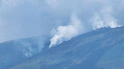
Degassing in the area of the main fissure on the edge of La Cumbre (Fernandina). Photo: Galapagos National Park. 03/13/2024
Gas:
The Mounts satellite system detected 576 tons of sulfur dioxide (SO2) at 1:57 p.m. TL on 03/13/2024.
Other monitoring parameters:
The WorldView satellite system recorded 129 thermal anomalies over the past 12 hours. On the other hand, the MIROVA-MODIS satellite system recorded 1 very high thermal anomaly and 1 high thermal anomaly, and the MIROVA-VIIRS satellite system recorded 1 very high, 4 high and 1 moderate thermal anomaly in the last 24 hours .
Observation:
Thanks to the GOES-16 satellite system, a constant thermal anomaly is observed on the volcano. Eruptive activity continues to gradually decrease. It is important to indicate that
Fernandina Island does not have any human settlements, so there is no risk to the population.
Source : IGEPN
Photo : Parc national des Galapagos.
Mexico , Popocatepetl :
March 14, 11:00 a.m. (March 14, 5:00 p.m. GMT). Activity from the last 24 hours
96 exhalations were detected, accompanied by water vapor, volcanic gases and slight amounts of ash. Additionally, 966 minutes (16.1 h) of high frequency, low to very low amplitude tremors were identified.
Yesterday, at 5:15 p.m. (local time), the National Center for Communication and Operation of Civil Protection (Cenacom) reported light ash falls in the center and south of the state of Tlaxcala; Likewise, today at 07:10 a.m. (local time), light ash fall was reported in San Nicolás de los Ranchos, Nealtican, Atzompa, Tecuanipa, Huejotzingo, Chiautzingo, Juan C. Bonilla, Xoxtla, Coronango, Puebla Capital, San Pedro. Cholula, San Andrés Cholula, San Juan Cuautlancingo and Amozoc de Mota in the state of Puebla.
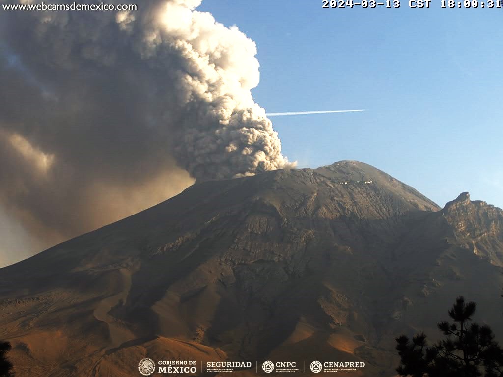
During the morning and at the time of this report, a continuous emission of water vapor and volcanic gases is observed, with dispersion towards the North-East (NE).
The Popocatépetl volcanic warning fire is in yellow phase 2.
The scenarios planned for this phase are:
A few small to moderate explosions
Appearance of tremors of variable amplitude
Light to moderate ash rain in surrounding towns and some more distant towns
Source et photo : Cenapred.