July 01 , 2019.
Papua New Guinea , Ulawun / Manam :
Papua New Guinea: Volcanoes Eruptions Information bulletin.
The situation
Ulawun Volcano eruption:
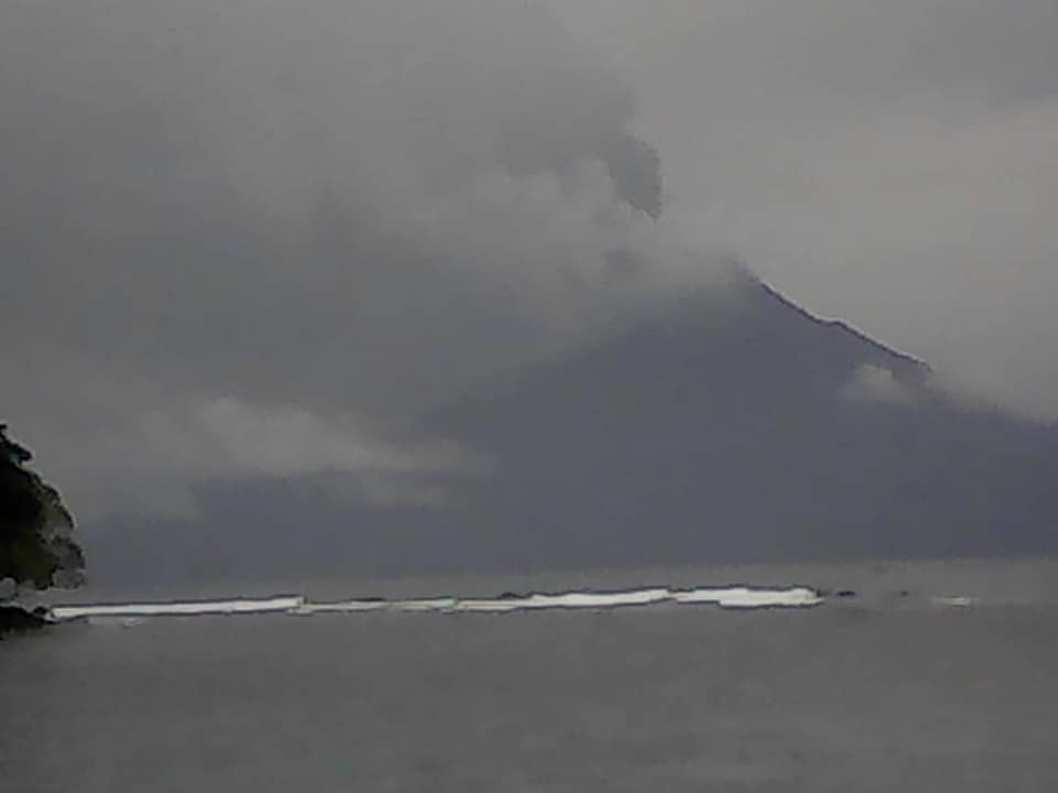
On 26 June 2019 at approximately 04:00 hours local time, the Ulawun volcano, about 130 km (81 miles) southwest of the township of Rabaul, East New Britain, has been observed continuously emitting ash plumes.
Darwin Volcanic Ash Advisory Centre (VACC) has increased the aviation colour code to RED at 06:33 hours local time on 26 June 2019. On 27 June 2019, the Darwin VACC stated that current satellite imagery indicated that the ash from the volcano had dissipated and there were no ongoing or new eruptions.
People living in the surrounding area of Ulawun Volcano were reported to have voluntarily evacuated the surrounding area on Wednesday, 26 June 2019. No damage or casualties have been reported. Approximately 10,620 people have sheltered at least ten care centre sites, according to local-level government authorities in Bialla, West New Britain as reported in UN Flash Update No.2. Another 427 people are in a single care centre in East New Britain. As of date, no casualties have been reported.
Due to the possible ashfall which has been observed across Kimbe township, the authorities in West New Britain have declared a provincial state of emergency and have activated their emergency response plan for Mount Ulawun, including the establishment of a forward base in Bialla. All communities within a 20 kilometres radius of the volcano were instructed to relocate to designated safe zones.
Manam Volcano eruptions:
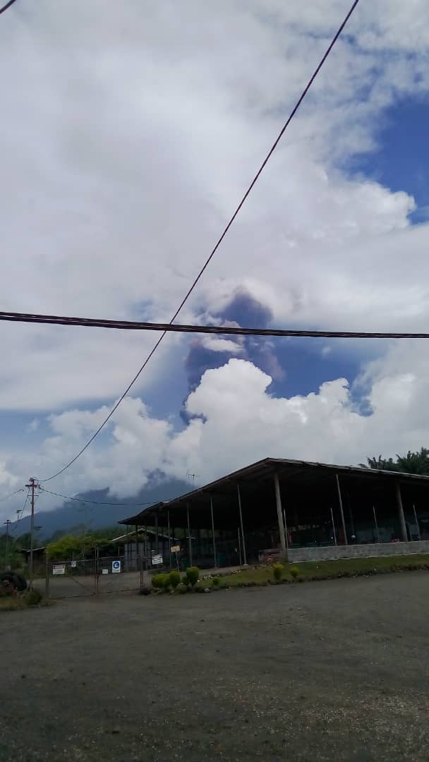
Based on the report from Rabaul Volcanological Observatory, on 28 June 2019 from around 07:00 hours (Papua New Guinean time), a volcanic activity was reported on a basaltic-andesitic stratovolcano1 , Manam Volcano (locally known as Manam Motu), in, Madang province, on the northeast coast of the mainland Papua New Guinea.
On 29 June 2019, as at 07:45 hours, local time, the volcano continues to erupt and emitting volcanic ash up to 4,572 meters (15,000 feets) and dispersing superheated pyroclastic flows to the west and northeast slopes of the volcano. Manam Volcano is a basaltic-andesitic stratovolcano On 28 June 2019, Volcanic Ash Advisory Center (VAAC) Darwin warned about a volcanic activity and ash plume that rose up to estimated 50,000 ft (15,200 meters) altitude or flight level 500.
The status at this point was 4 out of 5. According to PNG Disaster Management Team (DMT) Secretariat Update No. 1, approximately 755 households (3,775 people) have moved to three care centres. The largest is Baliau with 447 households (2,235 people), followed by Kuluguma with 182 households (910 people), while 76 households (380 people) are staying in Boda and 50 households (250 people) are staying in Iassa. Madang disaster authorities identified immediate needs for food and water. The PNG National Disaster Centre is coordinating with provincial authorities to deliver prepositioned relief supplies to Bogia and Manam island.
Source: Report from International Federation of Red Cross And Red Crescent Societies
Photos : Quentin Talingapua , EMTV
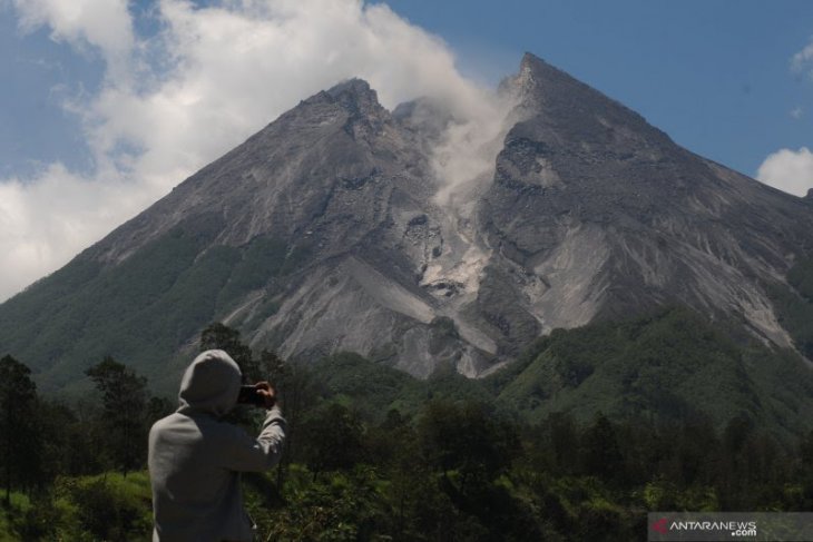
Indonesia , Merapi :
Mount Merapi spews lava avalanche as far as 850 meters in distance.
Yogyakarta (ANTARA) – Mount Merapi which located at the border area of Yogyakarta Special Region and Central Java spewed one lava avalanche on Sunday up to 850 meters in distance, according to the Geological Disaster Technology Research and Development Center (BPPTKG).
Lava avalanche monitored by surveillance cameras during the observation period from 12:00 to 6:00 a.m Western Indonesian Time (WIB) was flowing upstream of Gendol River, the Head of BPPTKG Hanik Humaida stated.
During the observation time, there were also two volcanic earthquakes monitored with amplitude ranging between 4 to 27 millimeters and lasting between 41.8 to 85 seconds.
In addition to this, visual observation result showed weak-pressured white crater smoke rose 20 meters above the crater’s peak.
The wind blew weakly to the direction of southwest and west, while the air temperature was recorded at 13 to 16.9 degrees Celsius; air humidity 45 to 95 percent; and air pressure 568 to 708.7 mmHg.
The BPPTKG maintained the status of Mount Merapi at level 2 or alert, and has temporarily advised against conducting climbing activities apart for disaster mitigation-related investigation and research.
The center has urged residents to not conduct any activities within a three-kilometers radius from the volcano’s peak, and called on residents living in the vicinity of Gendol River to intensify vigilance over the extent to which the hot clouds from Merapi will dissipate.
Source : ANTARA news.
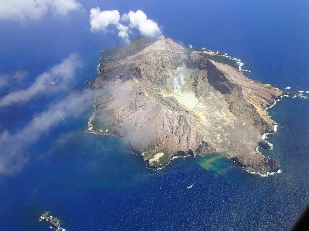
New Zealand , White Island :
Whakaari/White Island Volcanic Alert Level lowered to 1.Published: Mon Jul 1 2019 11:50 AM
Volcanic Alert BulletinWI–2019/06
Volcanic Alert Level is lowered to 1
Aviation Colour Code remains at Yellow
Whakaari/White Island shows lower level of gas emissions and the Volcanic Alert Level is lowered to 1.
Two additional gas flights were performed since our last update and these showed lower gas emissions than recorded on Wednesday 26 June. Further modelling of monitoring data and new data collected on the island also suggest a lower level of activity than last reported. As a result, the Volcanic Alert Level has been lowered to 1 (from 2).
The two additional gas flights detected 880 tons/day of sulphur dioxide on Friday 28 June and 693 tons/day on Saturday 29 June, much lower values than the measurement made on Wednesday 26 June. Further gas measurements will be undertaken again as soon as conditions allow.
New measurements made on the island show no change in fumarole temperature. Modelling of ground deformation monitoring data also suggest that the small signal recorded on Whakaari/White Island is likely to be related to the nearby ongoing swarm of tectonic earthquakes, and not an increase in volcanic activity.
Nearby earthquake swarms are continuing, although at lower levels than we reported in previous bulletins.
The lower gas flux measured, new observations and modelling of monitoring data suggest that Whakaari/White Island is back to minor volcanic unrest. As such we have changed the Volcanic Alert Level down to 1. There is no change in the Aviation Colour Code: Yellow.
Volcano Alert Level 1 is mostly associated with volcanic unrest hazards.
GNS Science and the National Geohazards Monitoring Centre continues to closely monitor Whakaari/White Island for further signs of activity.
Source : Geonet /Agnes Mazot , Duty Volcanologist
Photo : Auteur Inconnu.
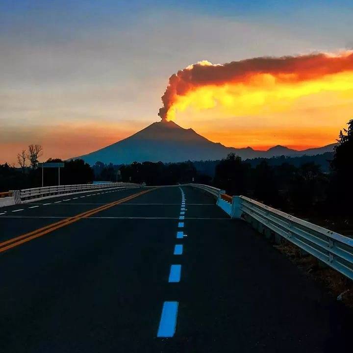
Mexico , Popocatepetl :
June 30, 11:00 am (June 30, 16:00 GMT)
In the past 24 hours, 169 exhalations have been identified using the Popocatépetl volcano monitoring systems, accompanied by water vapor, gas and light amounts of ash. There were 5 explosions, including two yesterday at 13:36 and 15:09, but due to weather conditions, the visibility did not allow to determine the height and direction, and three explosions recorded today at 00h52, 04h40 and 09h18 , with a moderate ash content. The explosion at 00:52 reached a column height of 1.5 km and dispersed in a south-easterly direction, projecting incandescent fragments on the slopes up to 1 km. The 04h40 explosion reached an approximate height of 1 km, dispersed in a south-easterly direction and projected glowing fragments over a short distance. The latest explosion was recorded today at 9:18 am, had a height of about 1.5 km and was initially dispersed to the southeast. In addition, a volcano-tectonic earthquake was recorded yesterday at 10:43 am, with a preliminary magnitude of 2.0 and 89 minutes of tremor.
At the time of writing, there was no visibility. However, any event will be scattered to the East-Southeast.
The monitoring system of the Popocatepetl volcano operates 24 hours a day. CENAPRED closely monitors any event. Any changes to the monitoring parameters will be reported promptly.
CENAPRED urges NOT to approach the volcano and especially the crater, because of the risk of falling ballistic fragments and, in case of heavy rains, to move away from the bottom of the ravines because of the risk of mudslide and debris.
The Popocatepetl warning light is located at YELLOW PHASE 2.
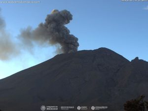
New explosion on Popocatépetl; It’s the fifth in 32 hours.
Despite the cloudiness present, it was possible to see the column of ashes.
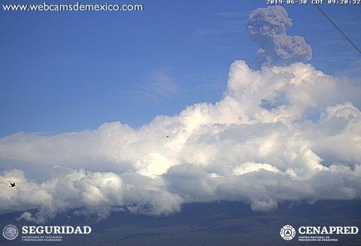
The National Coordination of Civil Protection (CNPC) announced that a new explosion had been recorded on the volcano Popocatépetl, but due to the extent of cloud cover, it was not fully observed.
Among the clouds, according to the image shared on the social networks, one notices the column of ashes, product of the volcanic event. The explosion was recorded at 0918 and the emission column is about 1.5 km above the crater.
No changes are expected in the short term unless otherwise indicated by the National Center for Disaster Reduction (Cenapred). The volcanic warning light remains yellow phase 2.
Sources : Cenapred , Paralelo19.mx
Photos : Marco Antonio Nuñez , Webcamdemexico.