May 02 , 2023.
United States , Yellowstone :
44°25’48 » N 110°40’12 » W,
Summit Elevation 9203 ft (2805 m)
Current Volcano Alert Level: NORMAL
Current Aviation Color Code: GREEN
Recent Work and News
No eruptions of Steamboat Geyser were detected during the month of April, and the total number of eruptions for the year remains at two. It is difficult to assess the geyser’s activity because the Norris temperature monitoring network and seismic station YNM were down throughout the month, but the streamgage on Tantalus Creek, through which all water from Norris Geyser Basin drains, did not record obvious spikes that would be associated with Steamboat Geyser eruptions.
With the arrival of spring, field work by Yellowstone Volcano Observatory scientists is ramping up! May operations will include repairing the Norris temperature monitoring network, as well as installing semi-permanent GPS stations around Yellowstone National Park. These stations are intended to densify the continuous GPS network during the summer and are installed every spring and removed in the fall.
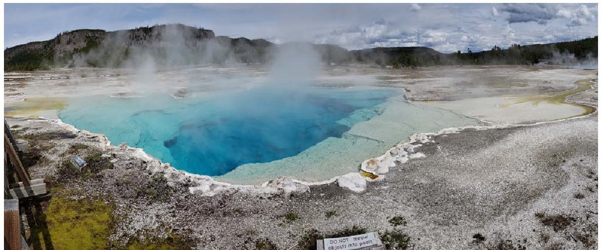
Sapphire Pool, an alkaline spring (pH ~7.5) in the Biscuit Basin area of the Upper Geyser Basin in Yellowstone National Park. The vent is hot (~80°C), with precipitation of white silica, but as the water cools in the outlet channel, the temperature drops below the upper temperature threshold for photosynthesis (~72°C ), as indicated by the sudden appearance of yellow-green from photosynthetic pigments produced by phototrophic bacteria.
Seismicity
During April 2023, the University of Utah Seismograph Stations, responsible for the operation and analysis of the Yellowstone Seismic Network, located 168 earthquakes in the Yellowstone National Park region. The largest event of the month was a minor earthquake of magnitude 2.5 located about 6 miles west-southwest of West Thumb in Yellowstone National Park on April 15 at 9:53 AM MDT.
April seismicity in Yellowstone was marked by two swarms:
1. A swarm of 50 earthquakes, under the eastern arm of Shoshone Lake about 6 miles west-southwest of West Thumb, in Yellowstone National Park, occurred April 15–19. The largest swarm earthquake, a magnitude 2.5, was the largest earthquake in April (described above).
2. A swarm of 33 earthquakes, approximately 3 miles northwest of West Thumb, in Yellowstone National Park, occurred April 24–26. The largest earthquake in the sequence, a magnitude 2.0, occurred April 24 at 7:04 PM MDT.
Earthquake sequences like these are common and account for roughly 50% of the total seismicity in the Yellowstone region.
Yellowstone earthquake activity is currently at background levels.
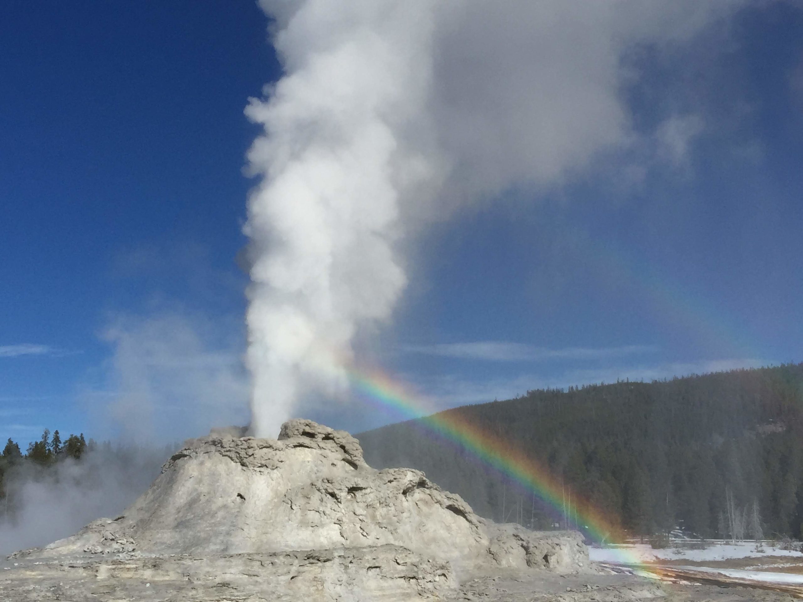
View of the erupting Castle Geyser near Old Faithful taken from the boardwalk on November 5, 2019.
Ground Deformation
Continuous GPS stations in and around Yellowstone National Park continued to record gradual subsidence at a rate of several centimeters (1–2 inches) per year, which has been ongoing since 2015. Since October, about 3 centimeters (1.2 inches) of subsidence has occurred in the caldera, and 2 centimeters (0.8 inch) of subsidence has occurred in the area of Norris Geyser Basin.
Source : YVO.
Photos : Jeff Havig, University of Minnesota , Shaul Hurwitz / USGS ,
Guadeloupe , La Soufrière :
Volcanic activity statement.
Sequence of earthquakes in the La Soufrière area of Guadeloupe – Basse Terre
The sequence of volcanic earthquakes which began on Friday April 21, 2023 at 9:50 p.m. local (Saturday April 22, 2023 at 01:50 UT) in the area of the La Soufrière volcano ended on Saturday April 29, 2023 at 7:30 p.m. local (Saturday April 29, 2023 11:30 p.m. GMT).
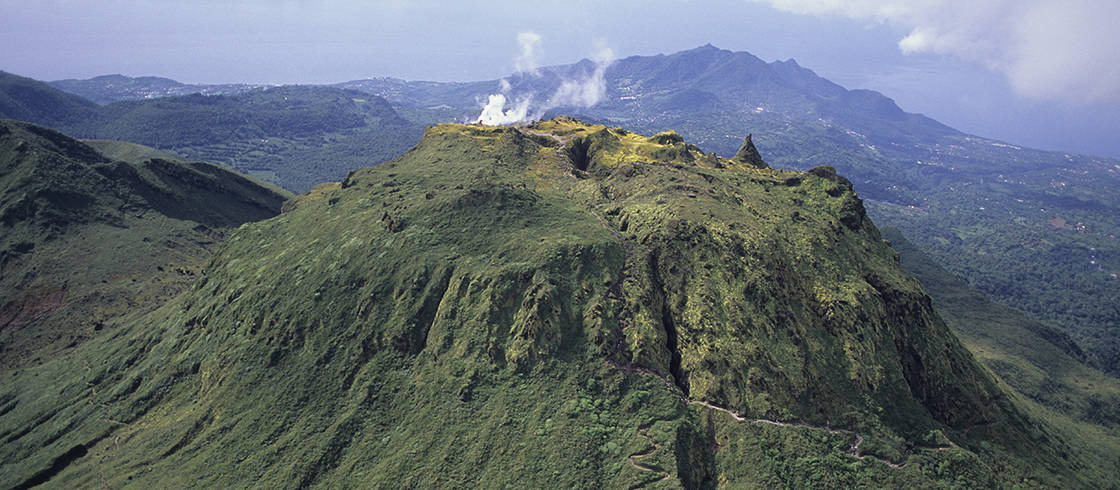
During this sequence, the OVSG-IPGP networks recorded 1193 earthquakes of very low magnitude (M < 1).
No earthquake was reported felt. The events are located at a depth of < 2.5 km below the summit of the dome of La Soufrière
The alert level remains: yellow, vigilance.
Source : Direction de l’OVSG-IPGP
Photo : P Giraud / ctig
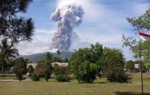
Indonesia , Ili Lewotolok :
An eruption of G. Ili Lewotolok occurred on Tuesday, May 02, 2023 at 05:28 WITA. The height of the eruptive column was observed at ± 500 m above the summit (± 1923 m above sea level). The ash column was white to gray with moderate intensity, oriented to the west and northwest. The eruption was recorded on a seismograph with a maximum amplitude of 20.5 mm and a duration of 46 seconds.
VOLCANO OBSERVATORY NOTICE FOR AVIATION – VONA
Issued : May 01 , 2023
Volcano : Ili Lewotolok (264230)
Current Aviation Colour Code : ORANGE
Previous Aviation Colour Code : orange
Source : Ili Lewotolok Volcano Observatory
Notice Number : 2023LEW017
Volcano Location : S 08 deg 16 min 19 sec E 123 deg 30 min 18 sec
Area : East Nusa Tenggara, Indonesia
Summit Elevation : 4554 FT (1423 M)
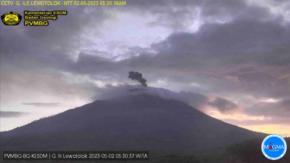
Volcanic Activity Summary :
Eruption with volcanic ash cloud at 21h28 UTC (05h28 local).
Volcanic Cloud Height :
Best estimate of ash-cloud top is around 6154 FT (1923 M) above sea level or 1600 FT (500 M) above summit. May be higher than what can be observed clearly. Source of height data: ground observer.
Other Volcanic Cloud Information :
Ash cloud moving from west to northwest. Volcanic ash is observed to be white to gray. The intensity of volcanic ash is observed to be medium.
Remarks :
Eruption recorded on seismogram with maximum amplitude 20.5 mm and maximum duration 46 second.
Source et photo : Magma Indonésie .
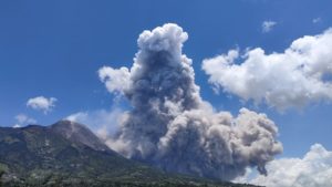
Colombia , Nevado del Ruiz :
Manizales, May 1, 2023 9:20 a.m.
Regarding the monitoring of the activity of the NEVADO DEL RUIZ VOLCANO, the MINISTRY OF MINES AND ENERGY through the COLOMBIAN GEOLOGICAL SERVICE (SGC) informs that:
Yesterday April 30 and until today, the seismic activity related to the movement of fluids inside the volcanic conduits continues to predominate, which maintains, in general, a similar behavior in terms of the number of earthquakes and of seismic energy compared to the previous day (April 29). Some such seismic signals this morning have been associated with pulsating ash emissions, confirmed by web cameras used for volcanic monitoring, highlighting the one recorded at 07:38, which reached a height of 600 m measured from the volcano summit and had a west-northwest dispersal direction.
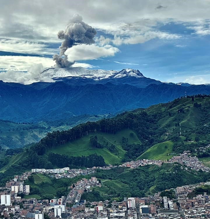
The seismic activity associated with the fracturing of the rock inside the volcanic edifice presented, on April 30, a similar behavior in the number of earthquakes recorded and a slight increase in the seismic energy released, by compared to the day before. The seismicity was localized around the Arenas crater, within a radius of less than 4.0 km, measured from there. The maximum magnitude recorded yesterday was 2.0 corresponding to the 03:06 earthquake. located 0.7 km northeast of the Arenas crater, 3.0 km deep, which was reported, opportunely, in yesterday’s extraordinary bulletin.
Compared to the maximum height of the column of gas and / or ash observed, it reached yesterday 1600 m measured from the summit of the volcano and presented a direction of dispersion mainly to the North-West and South-West of it. . Thermal anomalies continue at the bottom of the crater, which could be observed from satellite monitoring platforms, as well as the degassing of sulfur dioxide in the atmosphere and the release of water vapor from the volcano.
The level of activity of the volcano remains at the ORANGE LEVEL of activity or (II): PROBABLE ERUPTION IN TERM OF DAYS OR WEEKS.
Source : SGC.
Photo : Alex Jimenez Matiz
Ecuador , Cotopaxi :
DAILY REPORT OF THE STATE OF COTOPAXI VOLCANO, Monday May 01, 2023.
Information Geophysical Institute – EPN.
Surface Activity Level: Moderate, Surface Trend: Unchanged.
Internal activity level: Moderate, Internal trend: No change.
Seismicity: From April 30, 2023, 11:00 a.m. to May 01, 2023, 11:00 a.m.:
The seismic monitoring network of the Cotopaxi volcano has been operational for 24 hours.
Volcano-tectonics ( VT): 7
Tremor (TRE) 1
Long Period (LP): 11
Observation:
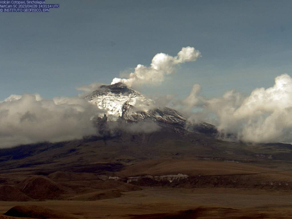
In the afternoon of yesterday slight gas emissions were observed at the level of the crater. During the night and early in the morning, the volcano remained cloudy.
Rains / Lahars:
According to the tambo camera, rains were observed in the volcano area. Since 01:30 TL, the BNAS seismic station has recorded high frequency seismic signals corresponding to the descent of very small mudslides (secondary lahars) limited to the interior of the Cotopaxi National Park.
Emission / Ash Column:
In the afternoon of yesterday slight gas emissions without ash content were observed at the level of the summit. Additionally, the Washington VAAC has not reported any ash emission alerts in the past 24 hours.
Niveau d’alerte: Jaune.
Source et photo : IGEPN