March 11 , 2023.
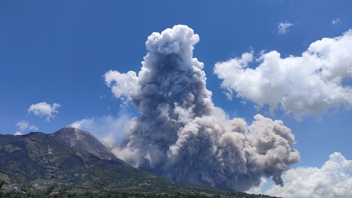
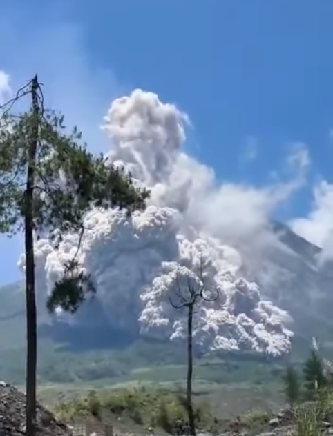
Indonesia , Merapi :
VOLCANO OBSERVATORY NOTICE FOR AVIATION – VONA
Issued : March 11 , 2023
Volcano : Merapi (263250)
Current Aviation Colour Code : ORANGE
Previous Aviation Colour Code : orange
Source : Merapi Volcano Observatory
Notice Number : 2023MER002
Volcano Location : S 07 deg 32 min 31 sec E 110 deg 26 min 31 sec
Area : Special Region of Yogyakarta, Indonesia
Summit Elevation : 9498 FT (2968 M)
Volcanic Activity Summary :
Eruption with volcanic ash cloud at 06h06 UTC (13h06 local).
Volcanic Cloud Height :
Best estimate of ash-cloud top is around 19098 FT (5968 M) above sea level or 9600 FT (3000 M) above summit. May be higher than what can be observed clearly. Source of height data: ground observer.
Other Volcanic Cloud Information :
Ash cloud moving from west to northwest. Volcanic ash is observed to be white to gray. The intensity of volcanic ash is observed from medium to thick.
Remarks :
Eruption recorded on seismogram with maximum amplitude 70 mm and maximum duration 202 second. Ash fall generated by pyroclastic density currents
Report on the activity of Mount Merapi from March 03, 2023 to March 09, 2023, Published on March 10, 2023
RESULTS OF OBSERVATIONS
Visual
The weather around Mount Merapi is usually sunny in the morning and afternoon, while the evening is foggy. White smoke, thin to medium thickness, low pressure and 475 m high was observed from the observation post of Mount Merapi in Badaban on March 9, 2023 at 05:40 WIB.
This week there were 19 southwestward lava avalanches (the main ones to Kali Bebeng then Kali Boyong and Kali Sat/Putih) with a maximum slip distance of 1700m. The sound of avalanches was heard from Pos Babadan 6 times with low to medium intensity
On the Central dome and the South-West dome no significant change was observed. Based on aerial photos from January 13, 2023, the volume of the Southwest dome was measured at 1,598,700 m3 and the central dome at 2,267,400 m3.

Seismicity
This week, the seismicity of Mount Merapi showed:
553 deep volcanic earthquakes (VTA),
296 avalanche earthquakes (RF),
11 shallow volcanic earthquakes (VTB),
12 tectonic earthquakes (TT).
40 multi-phase (MP) earthquakes
The intensity of this week’s seismicity is still quite high.
Deformation
The deformation of Mount Merapi that was monitored using EDM and GPS this week shows no significant changes.
Rain and lahars:
This week, there was rain with a rain intensity of 57 mm/h for 46 minutes in Pos Kaliurang on March 4, 2023. No increase in the flow of rivers descending from Mount Merapi was reported.
Conclusion
Based on the results of visual and instrumental observations, it is concluded that:
-The volcanic activity of Mount Merapi is still quite high in the form of effusive eruption activity. The state of the activity is defined at the « SIAGA » level.
Sources : PVMBG, BPPTKG.
Photos : Magma Indonesia , redmi note / ndaru_tngm ,
Russia / Kuril Islands , Ebeko :
VOLCANO OBSERVATORY NOTICE FOR AVIATION (VONA)
Issued: March 10 , 2023
Volcano: Ebeko (CAVW #290380)
Current aviation colour code: ORANGE
Previous aviation colour code: orange
Source: KVERT
Notice Number: 2023-32
Volcano Location: N 50 deg 41 min E 156 deg 0 min
Area: Northern Kuriles, Russia
Summit Elevation: 1156 m (3791.68 ft)
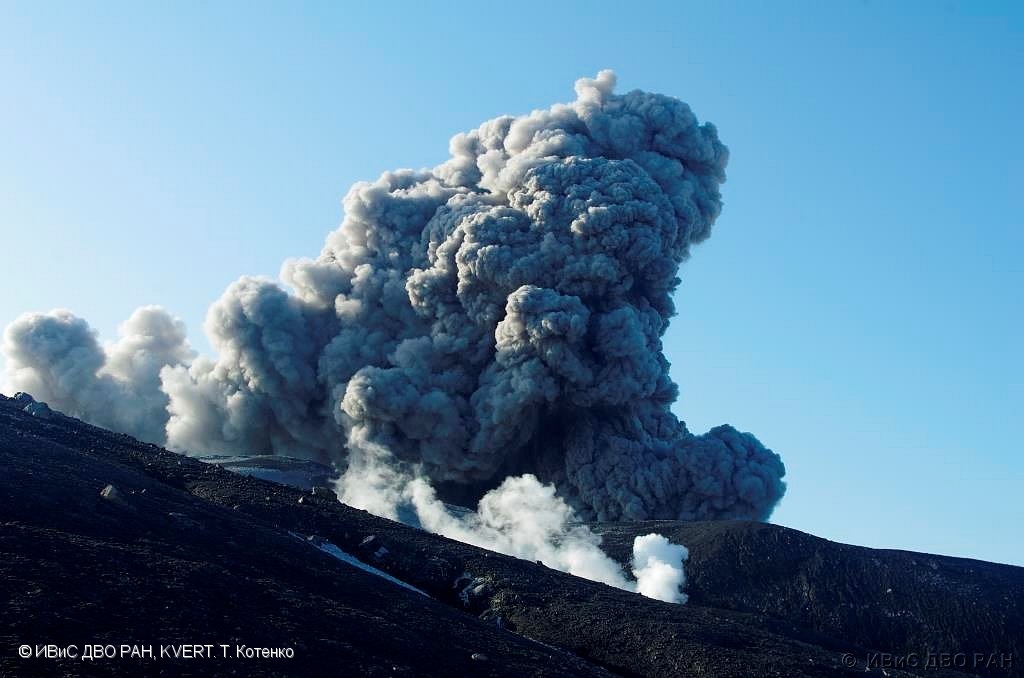
Volcanic Activity Summary:
A moderate explosive activity of the volcano continues. According to visual data by volcanologists from Severo-Kurilsk, an explosion sent ash up to 2.5 km a.s.l., an ash cloud is drifting to the north-east of the volcano.
A moderate eruptive activity of the volcano continues. Ash explosions up to 6 km (19,700 ft) a.s.l. could occur at any time. Ongoing activity could affect low-flying aircraft and airport of Severo-Kurilsk.
Volcanic cloud height:
2500 m (8200 ft) AMSL Time and method of ash plume/cloud height determination: 20230310/0522Z – Visual data
Other volcanic cloud information:
Distance of ash plume/cloud of the volcano: 5 km (3 mi)
Direction of drift of ash plume/cloud of the volcano: NE
Time and method of ash plume/cloud determination: 20230310/0522Z – Visual data
Source : Kvert
Photo : t totenko , ivs feb ras , kvert
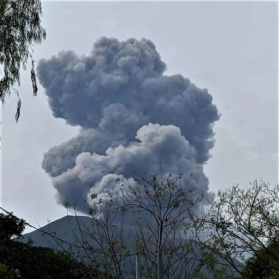
El Salvador , San Miguel ( Chaparrastique) :
The San Miguel volcano increases its activity
From 10:52 p.m. on Tuesday March 7, there was an increase in the degassing of the Chaparrastic volcano, in San Miguel, constantly in the early morning and early hours of this March 8.
The gas emission is continuous, the seismicity recordings show an increase in activity, so it is more likely to observe these periods of degassing and expulsion of ashes.
The San Miguel volcano is the most active in the country and could continue to show sudden increases in activity.
Faced with this situation, the General Directorate of Civil Protection published an Opinion this morning and issued the following recommendations:
Do not carry out tourist activities on the volcano, because the increase in this activity can be sudden.
Consult the official information and follow the indications of the authorities of the national civil protection system, which constantly monitors the activity of the volcano.
Maintain the security perimeter of a radius of 2 kilometers from the central crater of the volcano.
Be vigilant against any indicator of gas emanation and, if necessary, wear a mask to prevent respiratory illnesses, mainly for residents of the municipalities of San Jorge, Chinameca, San Rafael Oriente and areas near the volcano in the municipality of San Miguel.
It is recommended that the Departmental Civil Protection Commission of San Miguel and the municipal commissions of San Miguel, San Jorge, Chinameca and San Rafael Oriente activate their plans, in order to maintain local surveillance actions and attention to the population in case of need. .
Caution in agricultural and commercial activities near the crater. Likewise, take the measures they deem appropriate for the protection of crops and livestock.
Residents of the municipalities of San Miguel, Chinameca, San Jorge, and San Rafael Oriente should always be alert to any changes in volcano activity.
Source : Marn.
Photo : Rodolfo Salvatierra
Italy , Stromboli :
Statement on Stromboli activity, March 10, 2023, 13:39 (12:39 UTC).
The National Institute of Geophysics and Volcanology, Osservatorio Etneo, communicates that from the analysis of the images of the surveillance cameras, it has been observed that the lava flow described in the press release of 09/03 (17 :29 UTC) stalled during the early morning hours and the flow is gradually cooling.
From a seismic point of view, over the last 24 hours, the average amplitude of the volcanic tremor has remained mainly within the range of average values. There are no significant variations in the rate of occurrence and in the amplitude of the explosion tremors.
Data from the geodetic monitoring networks of the island of Stromboli show no significant variation in the last 24 hours.
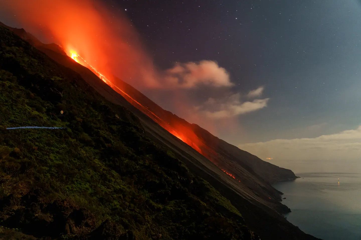
Statement on Stromboli activity, March 11, 2023, 04:41 (03:41 UTC).
The National Institute of Geophysics and Volcanology, Osservatorio Etneo, communicates that from the analysis of the images acquired by the surveillance cameras, it can be observed that the lava overflows from the northern zone of the crater. Due to weather conditions, it is not possible to define exactly the beginning of the effusive phenomenon, but from the data, thermal anomalies are observed in the upper sector of the Sciara del fuoco from 01:15 UTC with an increase at from 01:29 UTC.
From a seismic point of view, over the last 24 hours, the average amplitude of the volcanic tremor has remained mainly within the range of average values. There are no significant variations in the rate of occurrence and in the amplitude of the explosion tremors.
Data from geodetic monitoring networks on the island of Stromboli do not show any significant variations associated with the event.
Further updates will be communicated soon.
Source : INGV.
Photo : Stromboli stati d’animo.
Ecuador , Sangay :
DAILY REPORT OF THE STATE OF SANGAY VOLCANO, Friday March 10, 2023.
Information Geophysical Institute – EPN.
Surface Activity Level: High, Surface Trend: Unchanged
Internal activity level: High, Internal trend: No change
Seismicity: From March 09, 2023, 11:00 a.m. to March 10, 2023, 11:00 a.m.:
The reference station for seismic statistics operated normally. The level of seismic activity remains high.
Explosion (EXP) 120
Emission Tremors (TREMI ) 20

Rains / Lahars:
Several episodes of rain were recorded in the area yesterday afternoon, but no signal associated with mudslides and debris was generated. **In case of heavy rains, secondary lahars may be generated in the Volcán River, Upano and other tributaries**
Emission / Ash Column:
No emissions were seen on surveillance cameras, nor are there any reports from W-VAAC.
Other Monitoring Parameters:
No thermal alert for the Sangay volcano has been recorded on the satellite pages in the past 24 hours.
Observation:
At night, the volcano brightened occasionally and incandescence was observed in the crater accompanied by the descent of incandescent material into the ravine on the southeast flank. The rest of the time, the climatic conditions in the area prevented direct observations of surface activity.
Alert level: Orange.
Source : IGEPN
Photo : Lucas Scott / volcan Sangay