March 30, 2023. EN. Italy : Stromboli , Colombia : Nevado del Ruiz , Italy : Vulcano , Colombia : Chiles / Cerro Negro , Indonesia : Semeru , Chile : Planchon – Peteroa .

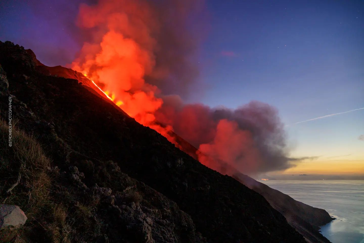
March 30 , 2023.


Italy , Stromboli :

WEEKLY BULLETIN, from March 20, 2023 to March 26, 2023. (issue date March 28, 2023).

ACTIVITY STATUS SUMMARY

In the light of the monitoring data, it is highlighted:
1) VOLCANOLOGICAL OBSERVATIONS: During this period, normal Strombolian activity was observed with spatter activity from the northern area of the crater, interrupted by a lava overflow that occurred between March 23 and 26 from the North zone and by a major explosive event that occurred on March 25 from the Center-South zone. The total hourly frequency of explosions fluctuated between medium (11 events/h) and medium-high (18 events/h); the intensity was mainly medium-low in both the North crater area and the Center-South crater area.
2) SEISMOLOGY: The seismological parameters monitored do not show any significant variations, with the exception of the explosive sequence recorded on 03/25/2023.
3) SOIL DEFORMATIONS: The island’s soil deformation monitoring networks did not show any significant variation to communicate for the period considered, apart from a small impulsive variation on the TDF inclinometers, coupled with the explosion of more great intensity of March 25.
4) GEOCHEMISTRY: the flow of SO2 is at an average level.
The CO2 streams show average degassing values.
The C/S values are at average values.
Isotope ratio of dissolved helium in heat sinks: There are no updates.
5) SATELLITE OBSERVATIONS: Thermal activity observed by satellite was generally moderate to high.

VOLCANOLOGICAL OBSERVATIONS
During the observation period, the eruptive activity of Stromboli was characterized by the analysis of the images recorded by the surveillance cameras of the INGV-OE at an altitude of 190 m (SCT-SCV) and of the Pizzo sopra la Fossa (SPT), while the Punta dei Corvi infrared camera (SPCT) was operational until 8:32 p.m. on March 21. The explosive activity was mainly produced by 3 (three) eruptive vents located in the North zone of the crater and by 4 (four) vents located in the Center-South zone.
Between March 21 and 26, due to unfavorable weather conditions, the visibility of the crater area was insufficient for a correct description of the eruptive activity.

Observations of explosive activity captured by surveillance cameras.
In the northern zone of the crater (N), characterized by two vents located in the N1 sector and by one in the N2 sector, an explosive activity of intensity varying from low (the products reached a height of less than 80 m) to medium – high (sometimes the products exceeded 150 m in height) emitting coarse materials (bombs and lapilli). In addition, splashing activity in the N1 sector was also observed, intense over long periods on March 24 and 25. The average frequency of explosions varied from 6 to 12 events/h.
In the Center-South zone (CS), sector S2, characterized by three active vents, showed explosive activity of medium-low intensity (less than 150 m in height) with emission of coarse materials. Sector C occasionally showed low-intensity explosive activity and intense throwing activity on March 22. Sector S1 showed no activity. The average hourly frequency in the Center-South zone varied between 5 and 7 events/h.

March 23 lava overflow.
On March 23, a lava overflow began from the N1 sector of the North Crater area. Below is the description of the event in UTC time.
Preceded by intense spattering activity, around 9:42 p.m., a lava flow began to flow from one of the two mouths of sector N1 following an overflow from the crater. After about an hour, the lava flow, which appeared to be well fed, entered the ravine created on October 9, 2022 and began to flow along the Sciara del Fuoco. Between 01:00 a.m. and 03:00 a.m. on March 26, the feed rate of the lava flow suddenly increased, producing landslides caused by the rupture of the lava front. From the early afternoon hours of the same day, the lava flow appeared to be starved and was gradually cooling. Overall, this effusive event lasted much longer than its predecessors in recent months. Due to the interruption of the images of the infrared camera of Punta dei Corvi (SPTC), it was not possible to verify if and when the volcanic products reached the coast.

March 25 event.
On March 25, a major event affected the area of the Center-South crater. Below is the description of the event in UTC time.
At 2:48:51 p.m., an explosive sequence began from one of the vents located in the southern part of sector S2; after a few seconds, other mouths are involved in the sequence. The emitted material was mainly mixed with fine and coarse material and exceeded the height of 300 m above the crater terrace; the main axis of dispersal was in the South-South-East direction.
From 14:49:31 some modest explosions of coarse material were produced by sector C. At 2:51:09 p.m., the explosion of coarse material began, followed by fine material, which ended the explosive sequence. The total duration of the event was approximately 3 minutes.

Source : INGV.

Photos : Stromboli stati d’animo.


Colombia , Nevado del Ruiz :

Manizales, March 29, 2023, 5:15 p.m.

Regarding the monitoring of the activity of the NEVADO DE RUIZ VOLCANO, the MINISTRY OF MINES AND ENERGY through the COLOMBIAN GEOLOGICAL SERVICE (SGC) informs that:

Since March 24, there has been a significant increase in seismic activity associated with rock fracturing in the volcanic edifice. This activity is located mainly 4.0 km southwest of the Arenas crater between 2.0 and 4.0 km deep. The recording of 6500 events stands out for March 28, it is the highest daily rate of earthquakes since 2010. The maximum magnitude to date is 2.7 ML (Local Magnitude), corresponding to the earthquake recorded today today at 6:01 a.m. It is also important to highlight the persistence of low to moderate energy thermal anomalies in the crater and the morphological changes in the lava dome.


Although this state of volcanic activity has been maintained for twelve years, it is important not to get used to this behavior and to be attentive to official information published by the Colombian Geological Service. The authorities of the departments of Caldas, Tolima, Risaralda, Quindío and Cundinamarca are invited to take extreme measures focused on knowledge processes and risk reduction, as well as disaster management as measures to prepare for the future activity of the Nevado del Ruiz volcano.

The activity level of the volcano remains at: YELLOW LEVEL (III): CHANGES IN THE BEHAVIOR OF VOLCANIC ACTIVITY

The COLOMBIAN GEOLOGICAL SERVICE will continue to monitor the evolution of the volcanic phenomenon and will inform in a timely manner of any changes that may occur.

Source: SGC.

Photo : SGC


Italy , Vulcano :

WEEKLY BULLETIN, from March 20, 2023 to March 26, 2023. (issue date March 28, 2023).

ACTIVITY STATUS SUMMARY

In the light of the monitoring data, it is highlighted:

1) Temperature of the crater fumaroles: The temperatures recorded on the edge of the crater are stable at high values.
2) CO2 fluxes in the crater area: stable CO2 fluxes on medium-high degassing values (7000 g/m2/day).
3) SO2 flux in the crater area: : decreasing towards an average level
4) Geochemistry of fumarolic gases: The chemical composition of fumarolic gases indicates constant values on the average levels of the concentration of magmatic species. The helium isotope ratio shows slightly decreasing values.
5) CO2 fluxes at the base of the La Fossa cone and in the Vulcano Porto area: In the Camping Sicilia and Rimessa sites, the CO2 fluxes show stable values but always above background levels; at the P4max site, the flows oscillate at medium-high levels, while at the Faraglione site, after a brief increase phase, the recorded values have returned to values close to the bottom.

6) Geochemistry of the thermal aquifers: The temperature in the Camping Sicilia well is at high values, while the conductivity is stable; in the Bambara well, no significant change in the monitored parameters was observed.
7) Local seismicity: The frequency of occurrence of local events was low, with values comparable to those of the previous week.
8) Regional seismicity: No earthquakes with a local magnitude equal to or greater than 1.0 were recorded.
9) Deformations – GNSS: The network of permanent GNSS stations has not recorded any significant variations.
10) Deformations – Inclinometry: The inclinometric network did not record any significant variations.
11) Gravimetry: No significant change was recorded.
12) Other Comments: Mobile GNSS.
The time series acquired so far by the mobile GNSS network do not show significant variations around the Porto di Levante area.

CRATER FUMEROLES TEMPERATURE .
The fumarolic field presented homogeneous emission temperatures along the summit fracture line, confirming a thermal anomaly maintained by a stable vapor flow. The emission temperature showed an hourly maximum of 361°C (T3) during the last 7 days. The hourly temperature range recorded on board is 308 to 361°C.

Source : INGV.

Photo : Filippo Parisi


Colombia , Chiles / Cerro Negro :

Weekly activity bulletin of the volcanic complex of Chiles and Cerro Negro (CVCCN)

Regarding the monitoring of the activity of the VOLCANOES CHILES AND CERRO NEGRO, the MINISTRY OF MINES AND ENERGY through the COLOMBIAN GEOLOGICAL SERVICE (SGC) informs that:

During the week of March 21 to 27, 2023 and compared to what had been reported the previous week, the seismic activity in the region of the Chiles and Cerro Negro volcanoes gradually decreased both in occurrence and in energy released, passing from 17717 to 12036 earthquakes.
It is recalled that seismicity continues with high and fluctuating levels, with a tendency to decrease and maintain the predominance of earthquakes associated with the fracture of the rock, although the recording of earthquakes related to the movement of fluids within the volcanic system is also maintained. This activity is always accompanied by a deformation of the surface of the CVCCN.

On March 25, there was a report of two felt earthquakes, with a magnitude of 2.9, recorded at 1:36 a.m. and 3:14 a.m. From the point of view of recording per day, for this week the daily occurrence of earthquakes was between 1032 and 2695 events.

The activity level of the volcano remains at YELLOW LEVEL (III): CHANGES IN THE BEHAVIOR OF VOLCANIC ACTIVITY

The COLOMBIAN GEOLOGICAL SERVICE and the GEOPHYSICAL INSTITUTE OF THE NATIONAL POLYTECHNICAL SCHOOL of ECUADOR will continue to monitor the evolution of the volcanic phenomenon and will inform in a timely manner of any changes that may occur.

Source et photo : SGC.


Indonesia , Semeru :

VOLCANO OBSERVATORY NOTICE FOR AVIATION – VONA

Issued : March 29 , 2023
Volcano : Semeru (263300)
Current Aviation Colour Code : ORANGE
Previous Aviation Colour Code : orange
Source : Semeru Volcano Observatory
Notice Number : 2023SMR109
Volcano Location : S 08 deg 06 min 29 sec E 112 deg 55 min 12 sec
Area : East java, Indonesia
Summit Elevation : 11763 FT (3676 M)

Volcanic Activity Summary :
Eruption with volcanic ash cloud at 00h14 UTC (07h14 local).

Volcanic Cloud Height :
Best estimate of ash-cloud top is around 13363 FT (4176 M) above sea level or 1600 FT (500 M) above summit. May be higher than what can be observed clearly. Source of height data: ground observer.

Other Volcanic Cloud Information :
Ash cloud moving from north to northeast. Volcanic ash is observed to be gray. The intensity of volcanic ash is observed to be thick.

Remarks :
Eruption recorded on seismogram with maximum amplitude 22 mm and maximum duration 110 second.

Source : Magma Indonésie.

Photo : Andi Volcanist.


Chile , Planchon – Peteroa :

Special Report on Volcanic Activity (REAV), Del Maule region, Planchon Peteroa volcanic complex, March 29, 2023, 2:20 p.m. local time (mainland Chile).

The National Service of Geology and Mines of Chile (Sernageomin) publishes the following PRELIMINARY information, obtained through the monitoring equipment of the National Volcanic Monitoring Network (RNVV), processed and analyzed at the Volcanological Observatory of the Southern Andes ( Ovdas):

On Wednesday March 29, 2023, at 1:59 p.m. local time (4:59 p.m. UTC), the monitoring stations installed near the Planchon Peteroa volcanic complex recorded an earthquake associated with rock fracturing (volcano-tectonic type VT) in the volcanic system.

The characteristics of earthquakes after their analysis are as follows:

ORIGINAL TIME: 1:59 p.m. local time (4:59 p.m. UTC)
LATITUDE: 35.203°S
LONGITUDE: 70.543°E
DEPTH: 2.4 km
LOCAL MAGNITUDE: 3.0 (ML)

COMMENTS:

No superficial activity was observed following the occurrence of this event.

The volcanic technical alert remains at the Green level.

Source et photo : Sernageomin


30 Mars 2023. FR. Italie : Stromboli , Colombie : Nevado del Ruiz , Italie : Vulcano , Colombie : Chiles / Cerro Negro , Indonésie : Semeru , Chili : Planchon – Peteroa .

30 Mars 2023.


Italie , Stromboli :

BULLETIN HEBDOMADAIRE , du 20 Mars 2023 au 26 Mars 2023 . (date d’émission 28 Mars 2023) .

RÉSUMÉ DE L’ÉTAT DE L’ACTIVITÉ

A la lumière des données de suivi, il est mis en évidence :
1) OBSERVATIONS VOLCANOLOGIQUES : Au cours de cette période, une activité strombolienne normale a été observée avec une activité d’éclaboussures de la zone Nord du cratère, interrompue par un débordement de lave qui s’est produit entre les 23 et 26 mars depuis la zone Nord et par un événement explosif majeur survenu le 25 mars depuis la zone Centre-Sud. La fréquence horaire totale des explosions a fluctué entre des valeurs moyennes (11 événements/h) et moyennes-élevées (18 événements/h) ; l’intensité était principalement moyenne-faible à la fois dans la zone du cratère Nord et dans la zone du cratère Centre-Sud.
2) SISMOLOGIE : Les paramètres sismologiques suivis ne présentent pas de variations significatives, à l’exception de la séquence explosive enregistrée le 25/03/2023.
3) DÉFORMATIONS DU SOL : Les réseaux de suivi des déformations des sols de l’île n’ont pas montré de variation significative à communiquer pour la période considérée, hormis une faible variation impulsive sur les inclinomètres TDF, couplée à l’explosion de plus grande intensité du 25 mars .
4) GEOCHIMIE : le flux de SO2 est à un niveau moyen.
Les flux de CO2 présentent des valeurs moyennes de dégazage.
Les valeurs C/S se situent à des valeurs moyennes.
Rapport isotopique de l’hélium dissous dans les puits thermiques : Il n’y a pas de mises à jour.
5) OBSERVATIONS SATELLITAIRES : L’activité thermique observée par satellite a généralement été modérée à élevée.

OBSERVATIONS VOLCANOLOGIQUES
Au cours de la période d’observation, l’activité éruptive du Stromboli a été caractérisée par l’analyse des images enregistrées par les caméras de surveillance de l’INGV-OE à une altitude de 190 m (SCT-SCV) et du Pizzo sopra la Fossa (SPT), tandis que la caméra infrarouge Punta dei Corvi (SPCT) était opérationnelle jusqu’à 20h32 le 21 mars. L’activité explosive a été principalement produite par 3 (trois) évents éruptifs situés dans la zone Nord du cratère et par 4 (quatre) évents situés dans la zone Centre-Sud  .
Entre le 21 et le 26 mars, en raison de conditions météorologiques défavorables, la visibilité de la zone du cratère était insuffisante pour une description correcte de l’activité éruptive.

Observations d’activité explosive captées par des caméras de surveillance.
Dans la zone Nord du cratère (N), caractérisée par deux évents situés dans le secteur N1 et par un dans le secteur N2, une activité explosive d’intensité variant de faible (les produits ont atteint une hauteur inférieure à 80 m) à moyenne-élevée (parfois les produits dépassaient 150 m de hauteur) émettant des matériaux grossiers (bombes et lapilli). Par ailleurs, une activité d’éclaboussures du secteur N1 a été observée également , intense sur de longues périodes les 24 et 25 mars. La fréquence moyenne des explosions variait de 6 à 12 événements/h.
Dans la zone Centre-Sud (CS), le secteur S2, caractérisé par trois évents actifs, a montré une activité explosive d’intensité moyenne-faible (moins de 150 m de hauteur) avec émission de matériaux grossiers. Le secteur C a occasionnellement montré une activité explosive de faible intensité et une intense activité de projection le 22 mars. Le secteur S1 n’a montré aucune activité. La fréquence horaire moyenne dans la zone Centre-Sud a varié entre 5 et 7 événements/h.

Débordement de lave du 23 mars.
Le 23 mars, un débordement de lave a commencé à partir du secteur N1 de la zone du cratère Nord. Vous trouverez ci-dessous la description de l’événement en heure UTC.
Précédée d’une intense activité d’éclaboussures, vers 21h42, une coulée de lave a commencé à s’écouler de l’une des deux bouches du secteur N1 suite à un débordement du cratère. Après environ une heure, la coulée de lave, qui semblait bien alimentée, est entrée dans le ravin créé le 9 octobre 2022 et a commencé à couler le long de la Sciara del Fuoco . Entre 01h00 et 03h00 le 26 mars, le débit d’alimentation du flux de lave a soudainement augmenté, produisant des glissements de terrain causés par la rupture du front de lave. À partir des premières heures de l’après-midi du même jour, la coulée de lave semblait être sous-alimentée et se refroidissait progressivement  . Dans l’ensemble, cet événement effusif a duré beaucoup plus longtemps que ses prédécesseurs ces derniers mois. En raison de l’interruption des images de la caméra infrarouge de Punta dei Corvi (SPTC), il n’a pas été possible de vérifier si et quand les produits volcaniques ont atteint la côte.

Evénement du 25 mars.
Le 25 mars, un événement majeur a affecté la zone du cratère Centre-Sud. Vous trouverez ci-dessous la description de l’événement en heure UTC.
A 14 h 48 min 51 s, une séquence explosive débute à partir d’une des bouches situées dans la partie Sud du secteur S2  ; après quelques secondes, d’autres bouches sont impliquées dans la séquence  . Les matériaux émis était principalement mélangé à des matériaux fins et grossiers et dépassaient la hauteur de 300 m au-dessus de la terrasse du cratère ; l’axe principal de dispersion était dans la direction Sud-Sud-Est.
A partir de 14:49:31 quelques modestes explosions de matériaux grossiers ont été produites par le secteur C . À 14 h 51 min 09 s, l’explosion de matériaux grossiers a commencé, suivie de matériaux fins, ce qui a mis fin à la séquence explosive . La durée totale de l’événement était d’environ 3 minutes.

Source : INGV.

Photos : Stromboli stati d’animo.


Colombie , Nevado del Ruiz :

Manizales, 29 mars 2023, 17h15

Concernant le suivi de l’activité du VOLCAN NEVADO DE RUIZ, le MINISTÈRE DES MINES ET DE L’ÉNERGIE à travers le SERVICE GÉOLOGIQUE COLOMBIEN (SGC) informe que :

Depuis le 24 mars, il y a eu une augmentation significative de l’activité sismique associée à la fracturation de la roche dans l’édifice volcanique. Cette activité est située principalement à 4,0 km au Sud-Ouest du cratère Arenas entre 2,0 et 4,0 km de profondeur. L’enregistrement de 6500 événements se démarque pour le 28 mars, c’est le taux quotidien de séismes le plus élevé depuis 2010. La magnitude maximale à ce jour est de 2,7 ML (Local Magnitude), correspondant au séisme enregistré aujourd’hui à 06h01 . Il est également important de souligner la persistance d’anomalies thermiques d’énergie faible à modérée dans le cratère et les changements morphologiques dans le dôme de lave.


Bien que cet état d’activité volcanique soit maintenu depuis douze ans, il est important de ne pas s’habituer à ce comportement et d’être attentif aux informations officielles publiées par le Service géologique colombien. Les autorités des départements de Caldas, Tolima, Risaralda, Quindío et Cundinamarca sont invitées à prendre des mesures extrêmes axées sur les processus de connaissance et la réduction des risques, ainsi que la gestion des catastrophes comme mesures pour se préparer à l’activité future du volcan Nevado del Ruiz.

Le niveau d’activité du volcan reste à : NIVEAU JAUNE (III) : CHANGEMENTS DANS LE COMPORTEMENT DE L’ACTIVITÉ VOLCANIQUE

Le SERVICE GÉOLOGIQUE COLOMBIEN  continuera à suivre l’évolution du phénomène volcanique et informera en temps opportun de tout changement qui pourrait survenir.

Source: SGC.

Photo : SGC


Italie , Vulcano :

BULLETIN HEBDOMADAIRE , du 20 Mars 2023 au 26 Mars 2023 . (date d’émission 28 Mars 2023) .

RÉSUMÉ DE L’ÉTAT DE L’ACTIVITÉ

A la lumière des données de suivi, il est mis en évidence :

1) Température des fumerolles du cratère : Les températures enregistrées sur le bord du cratère sont stables sur des valeurs élevées.
2) Flux de CO2 dans la zone du cratère : flux de CO2 stables sur des valeurs de dégazage moyennes-élevées (7000 g/m2/jour).
3) Flux de SO2 dans la zone du cratère : : décroissant vers un niveau moyen
4) Géochimie des gaz fumeroliens : La composition chimique des gaz fumeroliens indique des valeurs constantes sur les niveaux moyens de la concentration des espèces magmatiques. Le rapport isotopique de l’hélium montre des valeurs légèrement décroissantes.
5) Flux de CO2 à la base du cône de La Fossa et dans la zone de Vulcano Porto : Dans les sites Camping Sicilia et Rimessa, les flux de CO2 présentent des valeurs stables mais toujours supérieures aux niveaux de fond ; sur le site P4max les débits oscillent sur des niveaux moyens-élevés, tandis qu’au site de Faraglione, après une brève phase d’augmentation, les valeurs enregistrées sont revenues à des valeurs proches du fond.

6) Géochimie des aquifères thermiques : La température dans le puits Camping Sicilia se situe à des valeurs élevées, tandis que la conductivité est stable ; dans le puits Bambara, aucun changement significatif dans les paramètres surveillés n’a été observé.
7) Sismicité locale : La fréquence d’occurrence des événements locaux a été faible, avec des valeurs comparables à celles de la semaine précédente.
8) Sismicité régionale : Aucun tremblement de terre d’une magnitude locale égale ou supérieure à 1,0 n’a été enregistré.
9) Déformations – GNSS : Le réseau de stations GNSS permanentes n’a pas enregistré de variations significatives.
10) Déformations – Inclinométrie : Le réseau inclinométrique n’a pas enregistré de variations significatives.
11) Gravimétrie : Aucun changement significatif n’a été enregistré.
12) Autres commentaires : GNSS mobile.
Les séries temporelles acquises jusqu’à présent par le réseau GNSS mobile ne montrent pas de variations significatives autour de la zone de Porto di Levante.

TEMPÉRATURE DES FUMEROLES DU CRATERE .
Le champ fumerolien a présenté des températures d’émission homogènes tout au long de la ligne de fracture sommitale, confirmant une anomalie thermique entretenue par un flux de vapeur stable. La température d’émission a présenté un maximum horaire de 361 °C (T3) au cours des 7 derniers jours. L’amplitude horaire de température relevée au bord est de 308 à 361°C.

Source : INGV.

Photo : Filippo Parisi


Colombie , Chiles / Cerro Negro :

Bulletin d’activité hebdomadaire du complexe volcanique de Chiles et Cerro Negro (CVCCN)

Concernant le suivi de l’activité des VOLCANS CHILES ET CERRO NEGRO, le MINISTÈRE DES MINES ET DE L’ÉNERGIE à travers le SERVICE GÉOLOGIQUE COLOMBIEN (SGC) informe que :

Au cours de la semaine du 21 au 27 mars 2023 et par rapport à ce qui avait été signalé la semaine précédente, l’activité sismique dans la région des volcans Chiles et Cerro Negro a progressivement diminué tant en occurrence qu’en énergie libérée, passant de 17717 à 12036 tremblements de terre.
Il est rappelé que la sismicité se poursuit avec des niveaux élevés et fluctuants, avec une tendance à diminuer et à maintenir la prédominance des tremblements de terre associés à la fracture de la roche, bien que l’enregistrement de tremblements de terre liés au mouvement des fluides au sein du système volcanique soit également maintenu. Cette activité s’accompagne toujours d’une déformation de la surface du CVCCN.

Le 25 mars, il y a eu un rapport de deux tremblements de terre ressentis, d’une magnitude de 2,9, enregistrés à 1h36 du matin. et 3h14 Du point de vue de l’enregistrement par jour, pour cette semaine l’occurrence quotidienne des tremblements de terre était comprise entre 1032 et 2695 événements.

Le niveau d’activité du volcan reste au NIVEAU JAUNE (III) : CHANGEMENTS DANS LE COMPORTEMENT DE L’ACTIVITÉ VOLCANIQUE

Le SERVICE GÉOLOGIQUE COLOMBIEN et l’INSTITUT GÉOPHYSIQUE DE L’ÉCOLE NATIONALE POLYTECHNIQUE d’ÉQUATEUR continueront à suivre l’évolution du phénomène volcanique et informeront en temps opportun de tout changement qui pourrait survenir.

Source et photo : SGC.


Indonésie , Semeru :

AVIS D’OBSERVATION DU VOLCAN POUR L’AVIATION – VONA

Émis : 29 mars 2023
Volcan : Semeru (263300)
Code Couleur Aviation Actuel : ORANGE
Code Couleur Aviation précédent : orange
Source : Observatoire du volcan Semeru
Numéro d’avis : 2023SMR109
Emplacement du volcan : S 08 deg 06 min 29 sec E 112 deg 55 min 12 sec
Région : Java oriental, Indonésie
Altitude du sommet : 11763 FT (3676 M)

Résumé de l’activité volcanique :
Eruption avec nuage de cendres volcaniques à 00h14 UTC (07h14 locale).

Hauteur des nuages volcaniques :
La meilleure estimation du sommet du nuage de cendres est d’environ 13363 FT (4176 M) au-dessus du niveau de la mer ou 1600 FT (500 M) au-dessus du sommet. Peut être plus élevé que ce qui peut être observé clairement. Source des données de hauteur : observateur au sol.

Autres informations sur les nuages volcaniques :
Nuage de cendres se déplaçant du Nord au Nord-Est. On observe que la cendre volcanique est grise. On observe que l’intensité des cendres volcaniques est épaisse.

Remarques :
Eruption enregistrée sur sismogramme avec une amplitude maximale de 22 mm et une durée maximale de 110 secondes.

Source : Magma Indonésie.

Photo : Andi Volcanist.


Chili , Planchon – Peteroa :

Rapport spécial sur l’activité volcanique (REAV), région Del Maule, complexe volcanique Planchon Peteroa , 29 Mars 2023, 14 h 20, heure locale (Chili continental).

Le Service National de Géologie et des Mines du Chili (Sernageomin) publie les informations PRÉLIMINAIRES suivantes, obtenues grâce à l’équipement de surveillance du Réseau National de Surveillance Volcanique (RNVV), traitées et analysées à l’Observatoire Volcanologique des Andes du Sud (Ovdas):

Le Mercredi 29 Mars 2023, à 13h59 heure locale (16h59 UTC ), les stations de surveillance installées à proximité du complexe volcanique Planchon Peteroa ont enregistré un séisme associé à la fracturation des roches (type volcano-tectonique VT) dans le système volcanique.

Les caractéristiques des séismes après leur analyse sont les suivantes:

HEURE D’ORIGINE : 13h59 heure locale (16h59 UTC)
LATITUDE : 35.203° S
LONGITUDE : 70.543° E
PROFONDEUR : 2,4 km
MAGNITUDE LOCALE : 3,0 (ML)

OBSERVATIONS :

Il n’a pas été observé d’activité superficielle suite à la survenue de cet évènement .

L’alerte technique volcanique reste au niveau  Vert .

Source et photo : Sernageomin