March 30 , 2023.
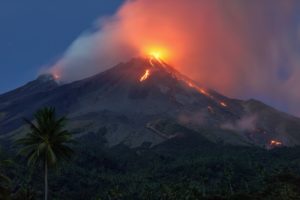
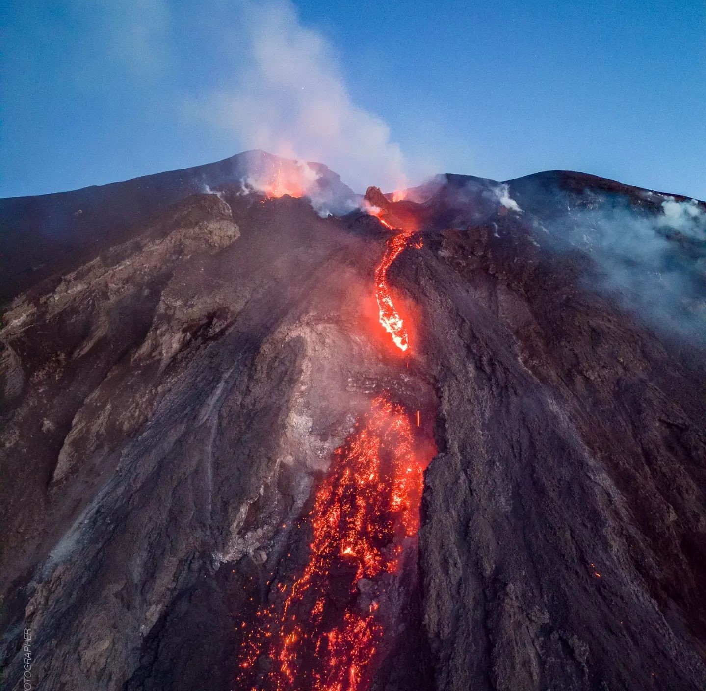
Italy , Stromboli :
WEEKLY BULLETIN, from March 20, 2023 to March 26, 2023. (issue date March 28, 2023).
ACTIVITY STATUS SUMMARY
In the light of the monitoring data, it is highlighted:
1) VOLCANOLOGICAL OBSERVATIONS: During this period, normal Strombolian activity was observed with spatter activity from the northern area of the crater, interrupted by a lava overflow that occurred between March 23 and 26 from the North zone and by a major explosive event that occurred on March 25 from the Center-South zone. The total hourly frequency of explosions fluctuated between medium (11 events/h) and medium-high (18 events/h); the intensity was mainly medium-low in both the North crater area and the Center-South crater area.
2) SEISMOLOGY: The seismological parameters monitored do not show any significant variations, with the exception of the explosive sequence recorded on 03/25/2023.
3) SOIL DEFORMATIONS: The island’s soil deformation monitoring networks did not show any significant variation to communicate for the period considered, apart from a small impulsive variation on the TDF inclinometers, coupled with the explosion of more great intensity of March 25.
4) GEOCHEMISTRY: the flow of SO2 is at an average level.
The CO2 streams show average degassing values.
The C/S values are at average values.
Isotope ratio of dissolved helium in heat sinks: There are no updates.
5) SATELLITE OBSERVATIONS: Thermal activity observed by satellite was generally moderate to high.
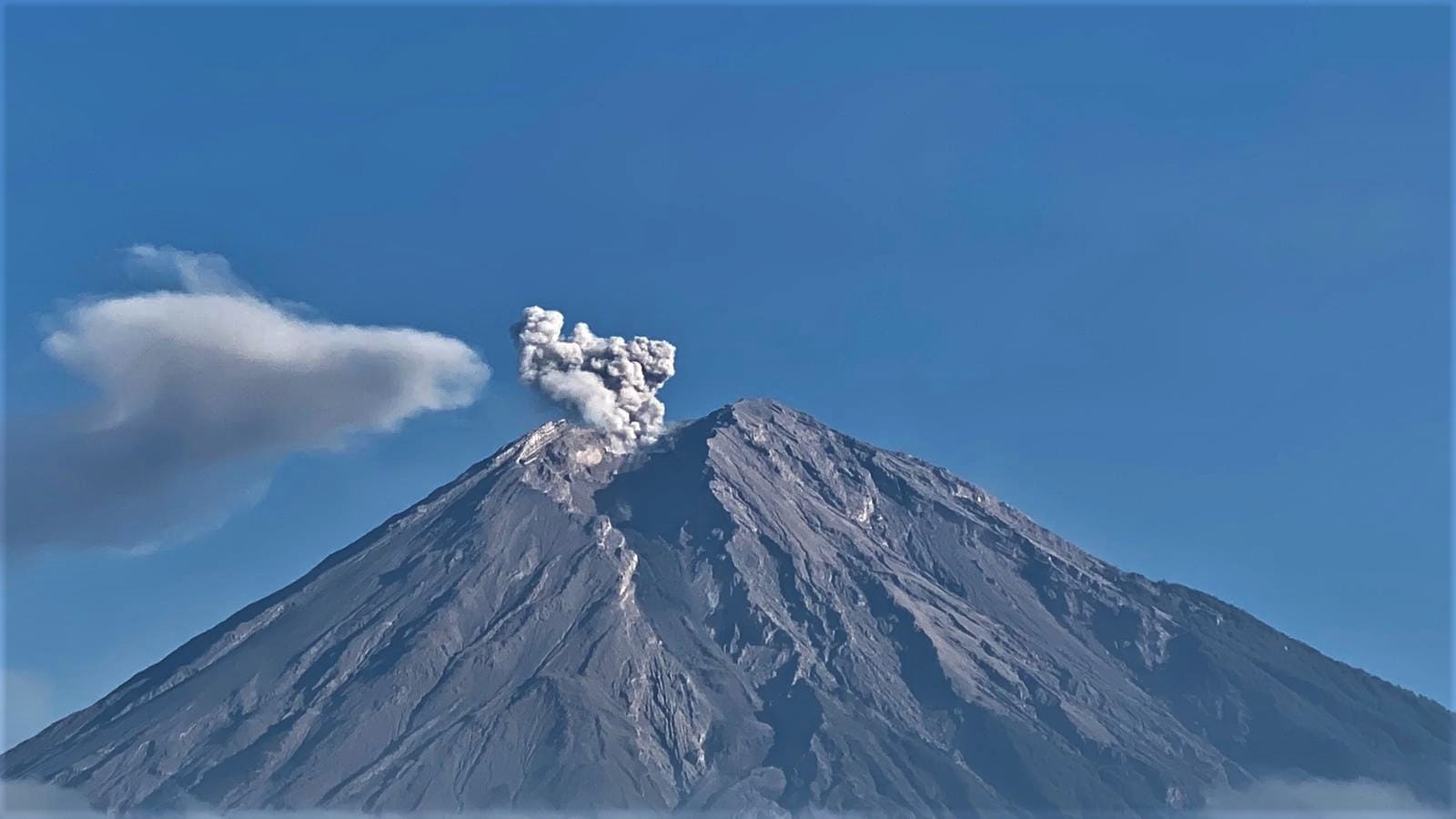
VOLCANOLOGICAL OBSERVATIONS
During the observation period, the eruptive activity of Stromboli was characterized by the analysis of the images recorded by the surveillance cameras of the INGV-OE at an altitude of 190 m (SCT-SCV) and of the Pizzo sopra la Fossa (SPT), while the Punta dei Corvi infrared camera (SPCT) was operational until 8:32 p.m. on March 21. The explosive activity was mainly produced by 3 (three) eruptive vents located in the North zone of the crater and by 4 (four) vents located in the Center-South zone.
Between March 21 and 26, due to unfavorable weather conditions, the visibility of the crater area was insufficient for a correct description of the eruptive activity.
Observations of explosive activity captured by surveillance cameras.
In the northern zone of the crater (N), characterized by two vents located in the N1 sector and by one in the N2 sector, an explosive activity of intensity varying from low (the products reached a height of less than 80 m) to medium – high (sometimes the products exceeded 150 m in height) emitting coarse materials (bombs and lapilli). In addition, splashing activity in the N1 sector was also observed, intense over long periods on March 24 and 25. The average frequency of explosions varied from 6 to 12 events/h.
In the Center-South zone (CS), sector S2, characterized by three active vents, showed explosive activity of medium-low intensity (less than 150 m in height) with emission of coarse materials. Sector C occasionally showed low-intensity explosive activity and intense throwing activity on March 22. Sector S1 showed no activity. The average hourly frequency in the Center-South zone varied between 5 and 7 events/h.
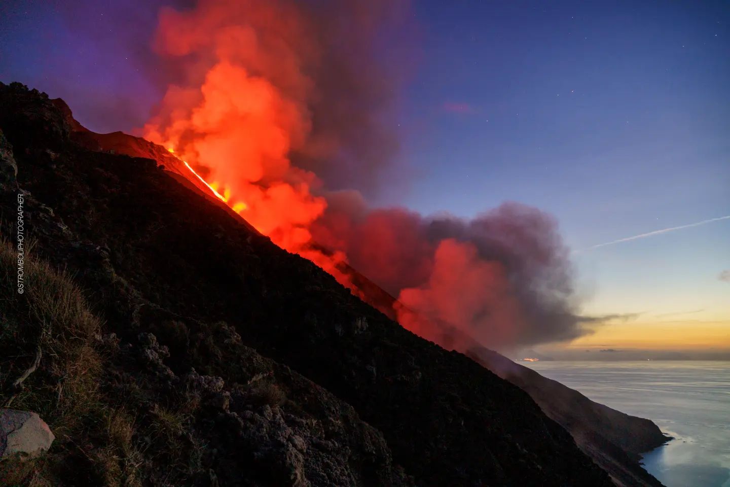
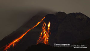
March 23 lava overflow.
On March 23, a lava overflow began from the N1 sector of the North Crater area. Below is the description of the event in UTC time.
Preceded by intense spattering activity, around 9:42 p.m., a lava flow began to flow from one of the two mouths of sector N1 following an overflow from the crater. After about an hour, the lava flow, which appeared to be well fed, entered the ravine created on October 9, 2022 and began to flow along the Sciara del Fuoco. Between 01:00 a.m. and 03:00 a.m. on March 26, the feed rate of the lava flow suddenly increased, producing landslides caused by the rupture of the lava front. From the early afternoon hours of the same day, the lava flow appeared to be starved and was gradually cooling. Overall, this effusive event lasted much longer than its predecessors in recent months. Due to the interruption of the images of the infrared camera of Punta dei Corvi (SPTC), it was not possible to verify if and when the volcanic products reached the coast.
March 25 event.
On March 25, a major event affected the area of the Center-South crater. Below is the description of the event in UTC time.
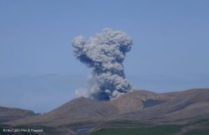
At 2:48:51 p.m., an explosive sequence began from one of the vents located in the southern part of sector S2; after a few seconds, other mouths are involved in the sequence. The emitted material was mainly mixed with fine and coarse material and exceeded the height of 300 m above the crater terrace; the main axis of dispersal was in the South-South-East direction.
From 14:49:31 some modest explosions of coarse material were produced by sector C. At 2:51:09 p.m., the explosion of coarse material began, followed by fine material, which ended the explosive sequence. The total duration of the event was approximately 3 minutes.
Source : INGV.
Photos : Stromboli stati d’animo.
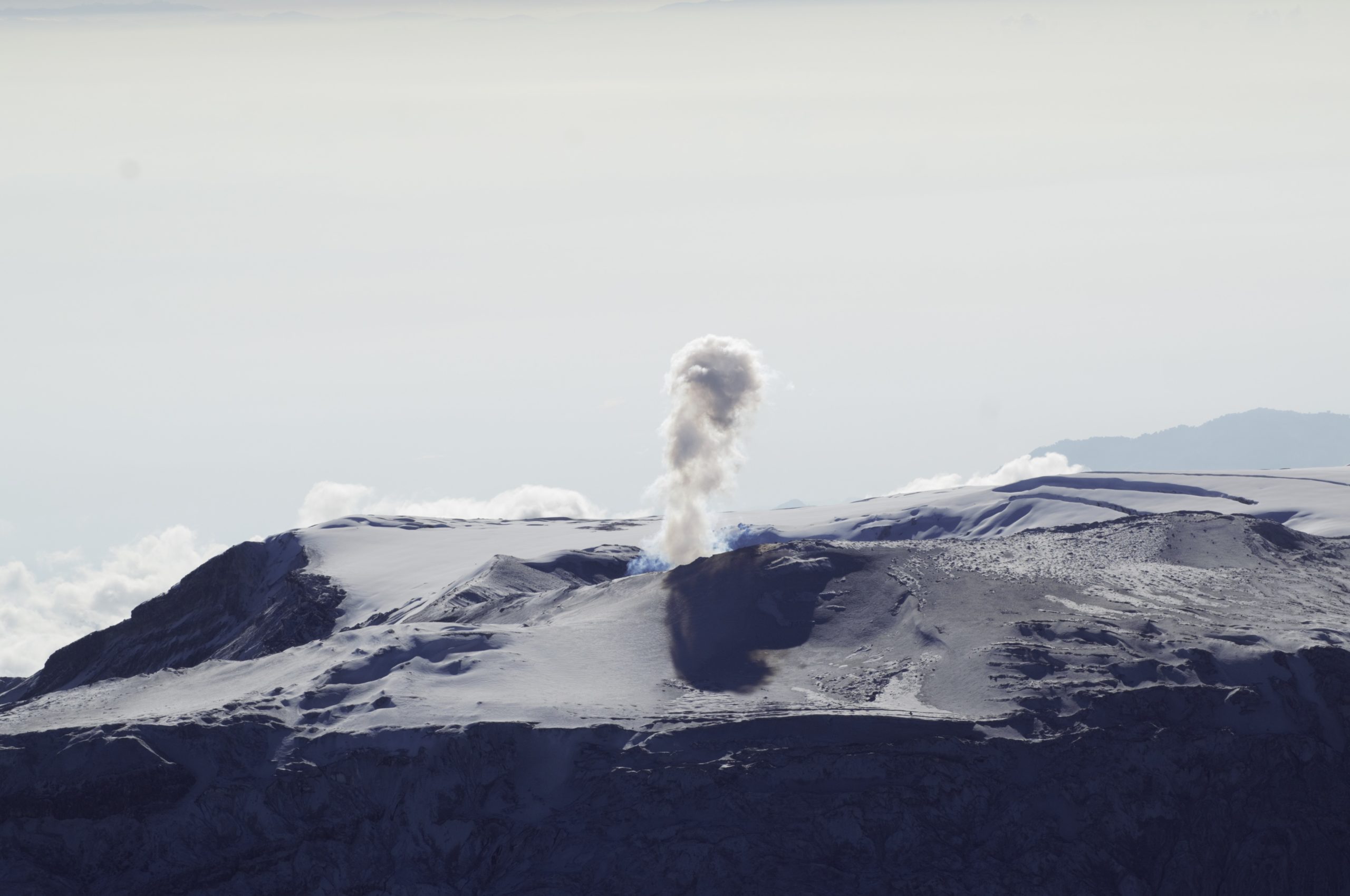
Colombia , Nevado del Ruiz :
Manizales, March 29, 2023, 5:15 p.m.
Regarding the monitoring of the activity of the NEVADO DE RUIZ VOLCANO, the MINISTRY OF MINES AND ENERGY through the COLOMBIAN GEOLOGICAL SERVICE (SGC) informs that:
Since March 24, there has been a significant increase in seismic activity associated with rock fracturing in the volcanic edifice. This activity is located mainly 4.0 km southwest of the Arenas crater between 2.0 and 4.0 km deep. The recording of 6500 events stands out for March 28, it is the highest daily rate of earthquakes since 2010. The maximum magnitude to date is 2.7 ML (Local Magnitude), corresponding to the earthquake recorded today today at 6:01 a.m. It is also important to highlight the persistence of low to moderate energy thermal anomalies in the crater and the morphological changes in the lava dome.
Although this state of volcanic activity has been maintained for twelve years, it is important not to get used to this behavior and to be attentive to official information published by the Colombian Geological Service. The authorities of the departments of Caldas, Tolima, Risaralda, Quindío and Cundinamarca are invited to take extreme measures focused on knowledge processes and risk reduction, as well as disaster management as measures to prepare for the future activity of the Nevado del Ruiz volcano.
The activity level of the volcano remains at: YELLOW LEVEL (III): CHANGES IN THE BEHAVIOR OF VOLCANIC ACTIVITY
The COLOMBIAN GEOLOGICAL SERVICE will continue to monitor the evolution of the volcanic phenomenon and will inform in a timely manner of any changes that may occur.
Source: SGC.
Photo : SGC
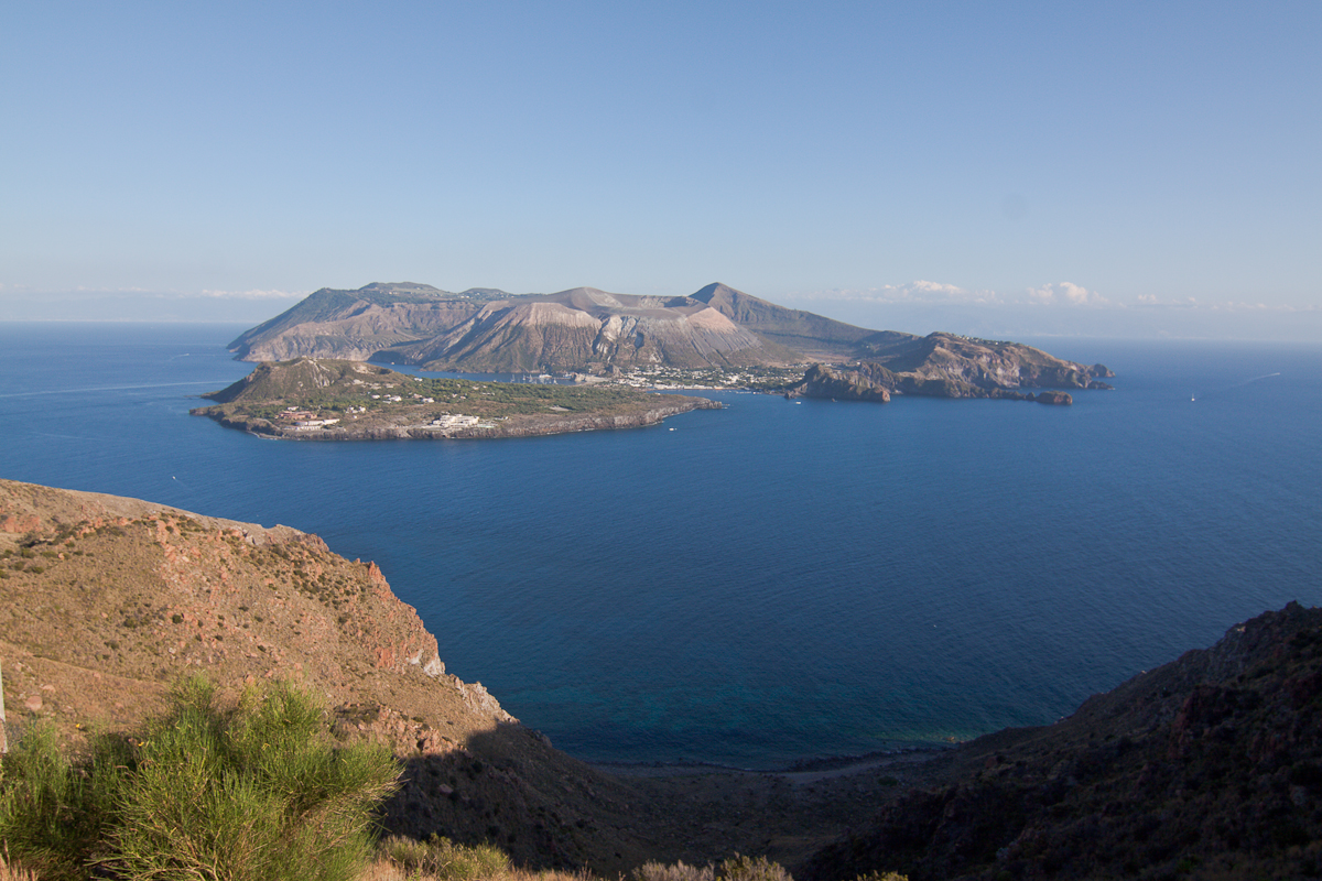
Italy , Vulcano :
WEEKLY BULLETIN, from March 20, 2023 to March 26, 2023. (issue date March 28, 2023).
ACTIVITY STATUS SUMMARY
In the light of the monitoring data, it is highlighted:
1) Temperature of the crater fumaroles: The temperatures recorded on the edge of the crater are stable at high values.
2) CO2 fluxes in the crater area: stable CO2 fluxes on medium-high degassing values (7000 g/m2/day).
3) SO2 flux in the crater area: : decreasing towards an average level
4) Geochemistry of fumarolic gases: The chemical composition of fumarolic gases indicates constant values on the average levels of the concentration of magmatic species. The helium isotope ratio shows slightly decreasing values.
5) CO2 fluxes at the base of the La Fossa cone and in the Vulcano Porto area: In the Camping Sicilia and Rimessa sites, the CO2 fluxes show stable values but always above background levels; at the P4max site, the flows oscillate at medium-high levels, while at the Faraglione site, after a brief increase phase, the recorded values have returned to values close to the bottom.
6) Geochemistry of the thermal aquifers: The temperature in the Camping Sicilia well is at high values, while the conductivity is stable; in the Bambara well, no significant change in the monitored parameters was observed.
7) Local seismicity: The frequency of occurrence of local events was low, with values comparable to those of the previous week.
8) Regional seismicity: No earthquakes with a local magnitude equal to or greater than 1.0 were recorded.
9) Deformations – GNSS: The network of permanent GNSS stations has not recorded any significant variations.
10) Deformations – Inclinometry: The inclinometric network did not record any significant variations.
11) Gravimetry: No significant change was recorded.
12) Other Comments: Mobile GNSS.
The time series acquired so far by the mobile GNSS network do not show significant variations around the Porto di Levante area.
CRATER FUMEROLES TEMPERATURE .
The fumarolic field presented homogeneous emission temperatures along the summit fracture line, confirming a thermal anomaly maintained by a stable vapor flow. The emission temperature showed an hourly maximum of 361°C (T3) during the last 7 days. The hourly temperature range recorded on board is 308 to 361°C.
Source : INGV.
Photo : Filippo Parisi
Colombia , Chiles / Cerro Negro :
Weekly activity bulletin of the volcanic complex of Chiles and Cerro Negro (CVCCN)
Regarding the monitoring of the activity of the VOLCANOES CHILES AND CERRO NEGRO, the MINISTRY OF MINES AND ENERGY through the COLOMBIAN GEOLOGICAL SERVICE (SGC) informs that:
During the week of March 21 to 27, 2023 and compared to what had been reported the previous week, the seismic activity in the region of the Chiles and Cerro Negro volcanoes gradually decreased both in occurrence and in energy released, passing from 17717 to 12036 earthquakes.
It is recalled that seismicity continues with high and fluctuating levels, with a tendency to decrease and maintain the predominance of earthquakes associated with the fracture of the rock, although the recording of earthquakes related to the movement of fluids within the volcanic system is also maintained. This activity is always accompanied by a deformation of the surface of the CVCCN.
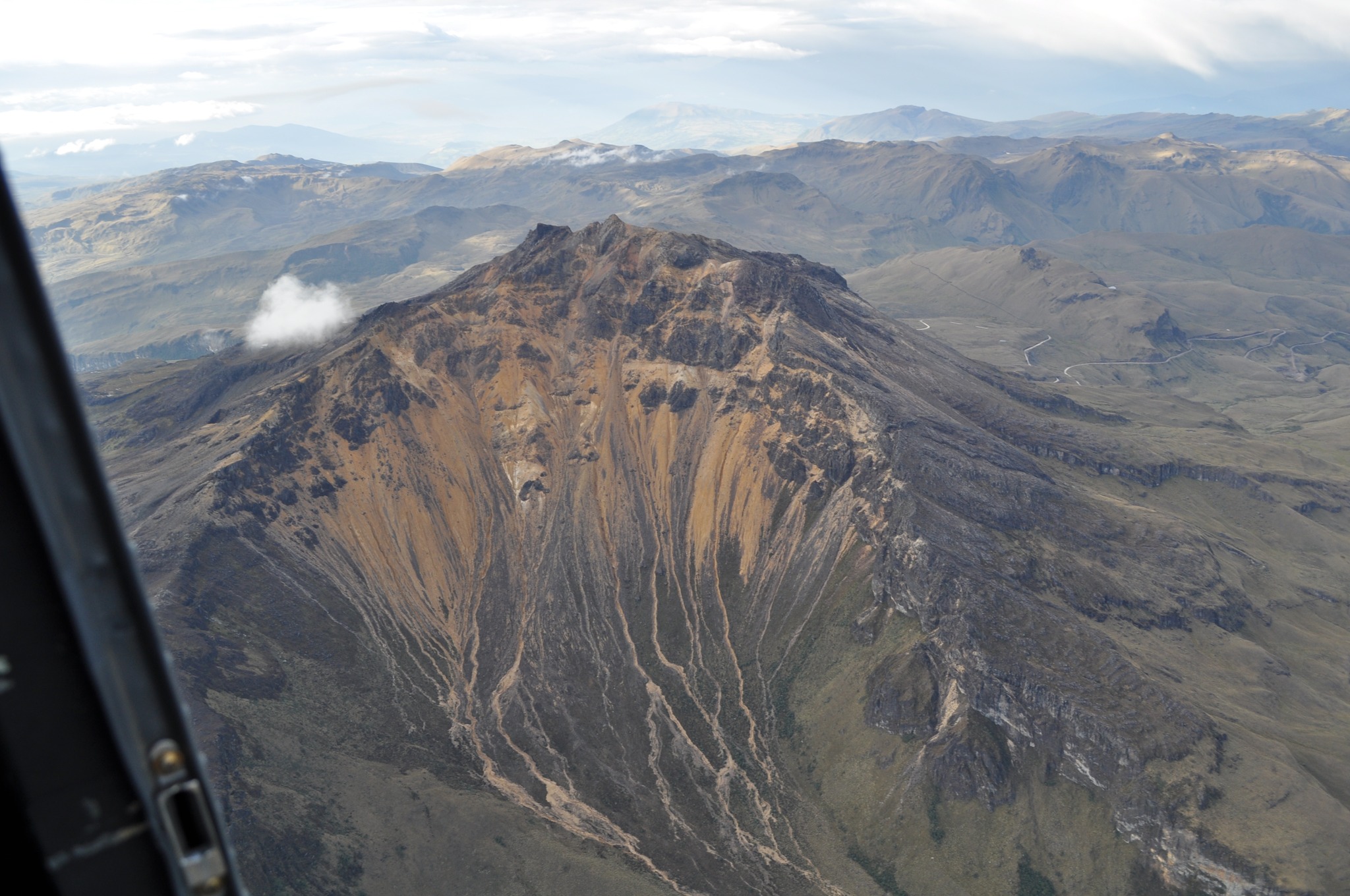
On March 25, there was a report of two felt earthquakes, with a magnitude of 2.9, recorded at 1:36 a.m. and 3:14 a.m. From the point of view of recording per day, for this week the daily occurrence of earthquakes was between 1032 and 2695 events.
The activity level of the volcano remains at YELLOW LEVEL (III): CHANGES IN THE BEHAVIOR OF VOLCANIC ACTIVITY
The COLOMBIAN GEOLOGICAL SERVICE and the GEOPHYSICAL INSTITUTE OF THE NATIONAL POLYTECHNICAL SCHOOL of ECUADOR will continue to monitor the evolution of the volcanic phenomenon and will inform in a timely manner of any changes that may occur.
Source et photo : SGC.
Indonesia , Semeru :
VOLCANO OBSERVATORY NOTICE FOR AVIATION – VONA
Issued : March 29 , 2023
Volcano : Semeru (263300)
Current Aviation Colour Code : ORANGE
Previous Aviation Colour Code : orange
Source : Semeru Volcano Observatory
Notice Number : 2023SMR109
Volcano Location : S 08 deg 06 min 29 sec E 112 deg 55 min 12 sec
Area : East java, Indonesia
Summit Elevation : 11763 FT (3676 M)
Volcanic Activity Summary :
Eruption with volcanic ash cloud at 00h14 UTC (07h14 local).
Volcanic Cloud Height :
Best estimate of ash-cloud top is around 13363 FT (4176 M) above sea level or 1600 FT (500 M) above summit. May be higher than what can be observed clearly. Source of height data: ground observer.
Other Volcanic Cloud Information :
Ash cloud moving from north to northeast. Volcanic ash is observed to be gray. The intensity of volcanic ash is observed to be thick.
Remarks :
Eruption recorded on seismogram with maximum amplitude 22 mm and maximum duration 110 second.
Source : Magma Indonésie.
Photo : Andi Volcanist.
Chile , Planchon – Peteroa :
Special Report on Volcanic Activity (REAV), Del Maule region, Planchon Peteroa volcanic complex, March 29, 2023, 2:20 p.m. local time (mainland Chile).
The National Service of Geology and Mines of Chile (Sernageomin) publishes the following PRELIMINARY information, obtained through the monitoring equipment of the National Volcanic Monitoring Network (RNVV), processed and analyzed at the Volcanological Observatory of the Southern Andes ( Ovdas):
On Wednesday March 29, 2023, at 1:59 p.m. local time (4:59 p.m. UTC), the monitoring stations installed near the Planchon Peteroa volcanic complex recorded an earthquake associated with rock fracturing (volcano-tectonic type VT) in the volcanic system.

The characteristics of earthquakes after their analysis are as follows:
ORIGINAL TIME: 1:59 p.m. local time (4:59 p.m. UTC)
LATITUDE: 35.203°S
LONGITUDE: 70.543°E
DEPTH: 2.4 km
LOCAL MAGNITUDE: 3.0 (ML)
COMMENTS:
No superficial activity was observed following the occurrence of this event.
The volcanic technical alert remains at the Green level.
Source et photo : Sernageomin