October 04 , 2018.
La Réunion , Piton de la Fournaise :
Activity Bulletin from Wednesday, October 3, 2018 to 14:00 (local time).
The eruption started on September 15th at 4:25 am local time continues. The intensity of the volcanic tremor (indicator of surface eruptive intensity) has remained relatively stable over the last 24 hours (Figure 1). However, since about 04:30 local time on this day (00:30 UTC), pistons gas (« gas flushes » or « tremor burst ») at the eruptive site are recorded by the seismometers of the OVPF. These « piston gases » mark a change of regime in the degassing of the eruption, and are generally observed when the quantity of available gas is exhausted, and often synonymous with a decrease of activity on the surface.
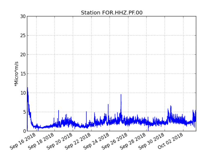
Figure 1: Evolution of the RSAM (indicator of the volcanic tremor and the intensity of the eruption) between 04h00 (00h UTC) on September 15th and 14h00 (10h00 UTC) on October 3rd on the FOR seismic station, located near the crater Chateau Fort (2000 m altitude on the southeast flank of the terminal cone).
– No volcano-tectonic earthquake was recorded during the day of 2 October, nor during the current day.
– An inflation (swelling) of the building, witnessing the influence of a source of pressure at the foot of the volcano, is still perceptible.
– The surface flows estimated from the satellite data, via the HOTVOLC platform (OPGC – Clermont Auvergne University) are between 1 m3 / s and 3 m3 / s over the last 24 hours.
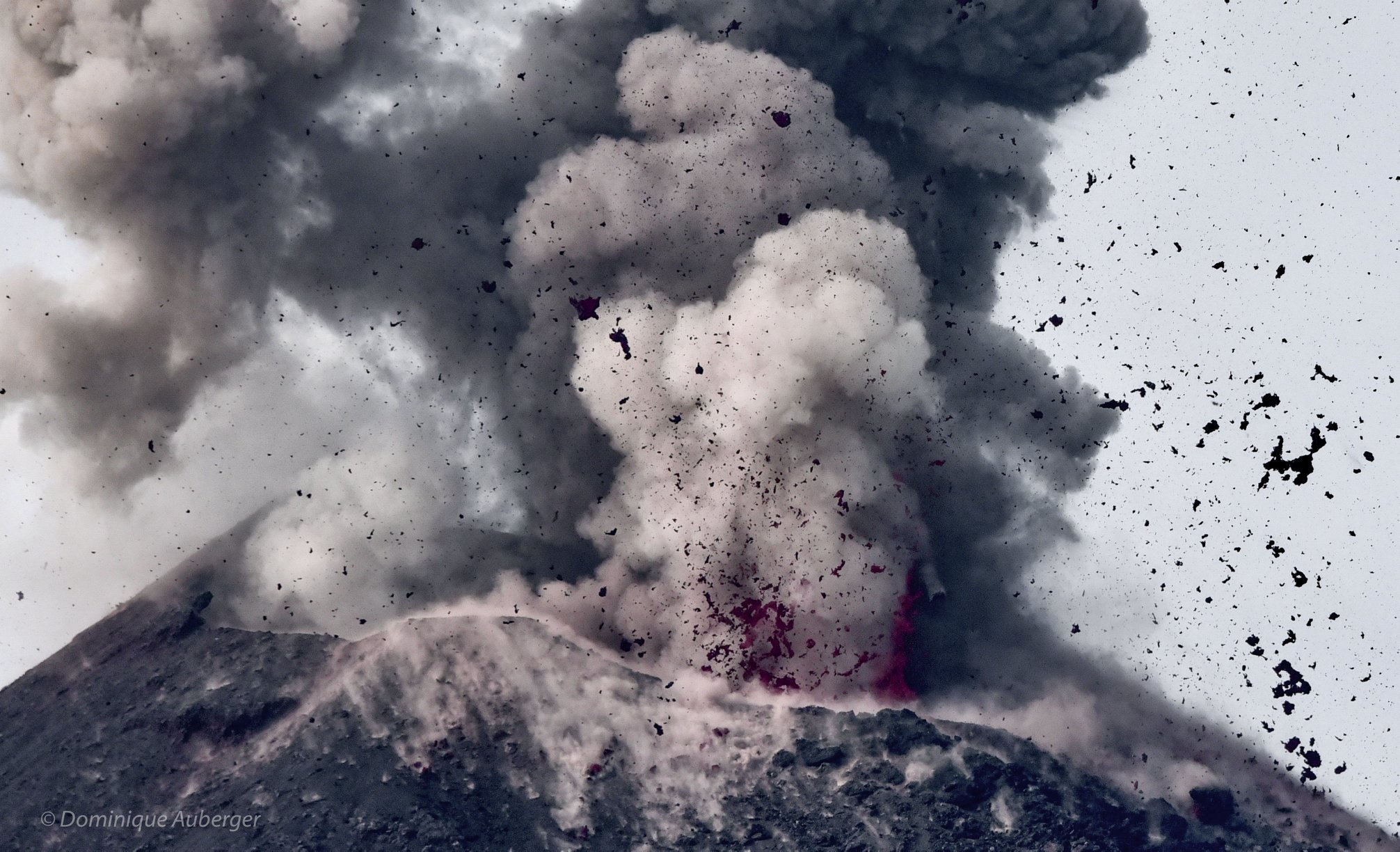
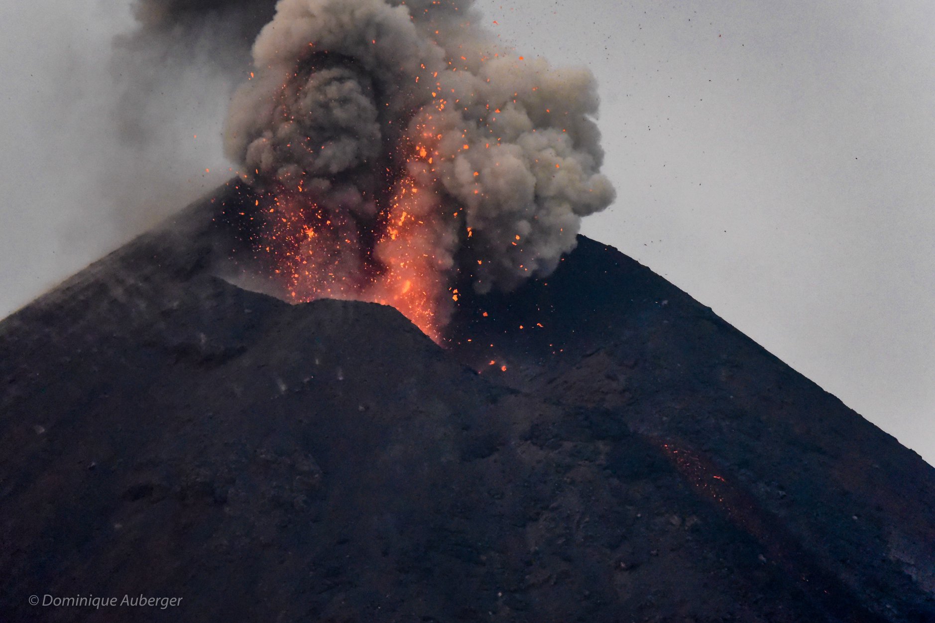
– An overflight of the eruptive site yesterday (October 2) by a team of the OVPF, reports a falling surface activity with rare lava projections at the level of the eruptive vent (Figure 2), and Lava outbreaks from the main lava tunnel of small extensions (<600 m).
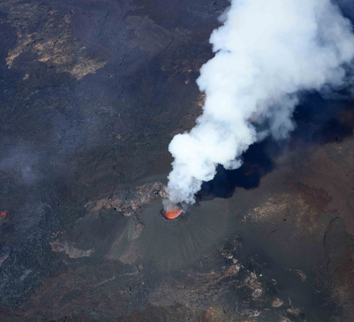
Figure 2: Shooting of the eruptive site on October 2, 2018 at 10:30 local time (© OVPF / IPGP).
Alert level: Alert 2-2 – Eruption in the Enclos .
Source : OVPF
Indonesia , Anak Krakatau :
6.102°S, 105.423°E
Elevation : 338 m
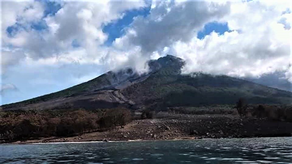
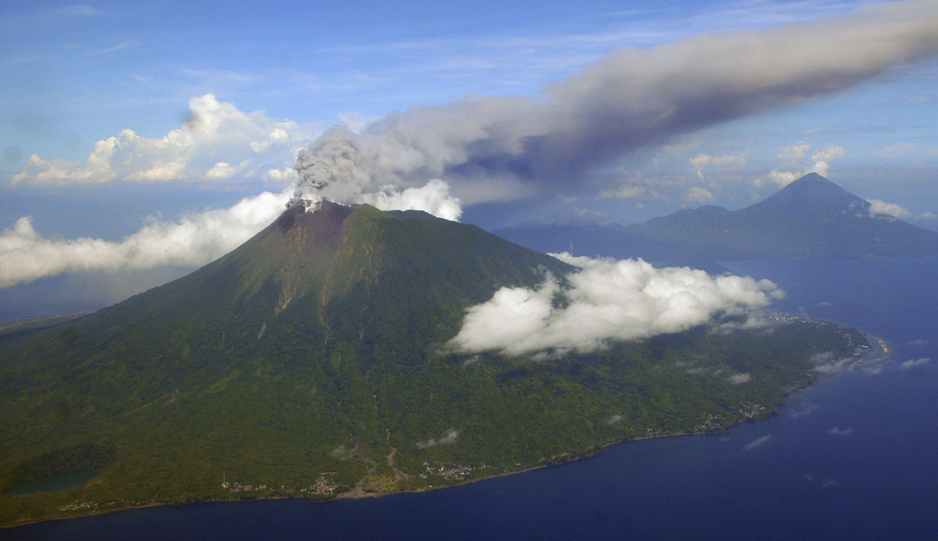
The Anak Krakatau volcano, located in the Sunda Strait, is a stratovolcan type volcano and a young volcano that appears in the caldera, after the 1883 paroximal eruption of the Krakatoa volcanic complex. Eruptive eruptive activity started in 1927 when the cone of the volcano was still below sea level. Since that time and until now, Anak Krakatau is in the construction phase (its cone becomes more large). Currently, the Anak Krakatau has the highest altitude of 338 meters above sea level (measured from September 2018). The character of the eruption is a magmatic rash in the form of a weak explosive eruption (Strombolian) and an effusive eruption in the form of lava flows. In 2016, the eruption occurred on June 20, while in 2017, the eruption occurred on February 19 in the form of Strombolian eruptions. In 2018, it erupted on June 29 and until now in the form of Strombolian eruptions.
The warning signs of an eruption in 2018 begin with the appearance of tremors, gusty earthquakes, and low-frequency type earthquakes on 18-19 June 2018. The number of gusts of earthquakes continued to increase and finally on June 29, 2018 the Anak Krakatau erupts.
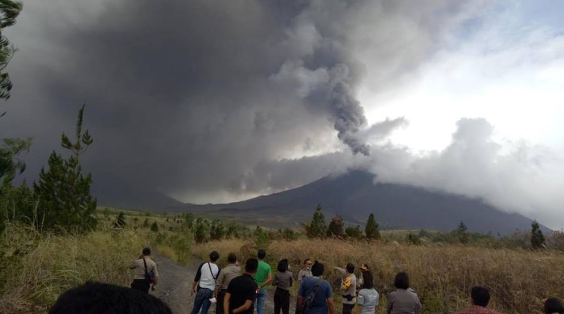
Projections of eruptive material fall mainly around the cone of Anak Krakatau or less than 1 km from the crater, but since July 23, fountains of incandescent material fall around the coast, so that the danger radius around the Mount Krakatau is 1 km to 2 km from the crater. .
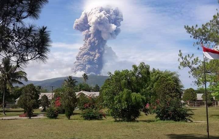
Recent activity, from September to the present, shows that eruptions are still in progress with thumps and vibrations at the Anak Krakatau PGA post, 42 km from the center of the eruption. Visual monitoring is often hampered by fog, when sunny weather has allowed continuous eruptions to be observed, eruption column heights ranging from 200 to 500 meters have been noted. The highest eruption column was observed up to 2500 m above the summit on 22 September. In general, the distribution of volcanic ash eruptions extends from the northwest to the southwest.
The seismicity is dominated by an average number of seismic events of 400 events per day and by continuous earthquakes with a maximum amplitude of 50 mm (excluding scale).
The Anak Krakatau eruption disaster potential, Map of Disaster-prone Areas (KRB), shows that almost the entire body of Mount Anak Krakatau ± 2 km in diameter is an area prone to disasters. Based on data from the potential visual and instrumental hazards of Mount Anak Krakatau, the activity at the moment is explosions of incandescent material within a radius of 2 km around the center of the eruption. While the distribution of volcanic ash depends on the direction and speed of the wind.
Based on observations and analysis of visual and instrumental data up to October 3, 2018, the activity level of Anak Krakatau is still level II (Waspada). For Waspada level II status, it is recommended to prevent people from approaching G. Anak Krakatau within a radius of 2 km around the crater. Coastal communities in Banten and Lampung Provinces should be calm and can carry out their activities as usual, always following the instructions of the local BPBD.
Based on satellite data, wind model data, and notices from PVMBG, the Darwin VAAC reported that during 25 September-2 October ash plumes from Anak Krakatau rose to altitudes of 1.2-2.1 km (4,000-7,000 ft) a.s.l. and drifted W, WSW, and SW. The Alert Level remained at 2 (on a scale of 1-4); residents and visitors were warned not to approach the volcano within 2 km of the crater.
Source : PVMBG , GVP.
Photo : D. Auberger /John Van Marcke / Facebook.
Indonesia , Soputan :
1.112°N, 124.737°E
Elevation 1785 m
Levelof activity at Level III (SIAGA). The volcanic activity of Soputan (1,784 m above sea level) has increased. Since yesterday and until this morning, the volcano was visually cleared until it was covered with fog, a column of smoke eruption was observed at an altitude between 2000 and 6000 m above the summit. The wind is blowing weakly in the southwest – northwest.
Thanks to the seismographs, on October 3rd, 2018, it was recorded:
4 earthquakes of eruptions
87 avalanche earthquakes
286 emission earthquakes.
20 shallow volcanic earthquakes
45 deep volcanic earthquakes
A continuous tremor with a maximum amplitude of 1 to 42 mm and a dominant value of 42 mm.
Recommendation: Communities must not be active within 4 km of the summit of Mount Soputan or in a west-southwest direction of 6.5 km, which constitutes a crater opening area, in order to avoid the risk of lava avalanches and hot cloud avalanches.
VONA: The latest code VONA sent the color code ORANGE, published on October 3, 2018 at 23:58, relating to the eruption with the height of the ash column located at 4309 m above sea level or at about 2500 m above the summit, the wind blowing to the northwest.
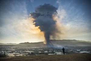
PVMBG reported that increased seismicity at Soputan was notable on 2 October, characterized by an increased number of signals indicating emissions and avalanches (which began in September and mid-July, respectively), increased RSAM values, and a higher number of volcanic earthquakes (since September). Data from a thermal camera showed increased summit temperatures, indicating the presence of lava. The Alert Level was increased to 3 (on a scale of 1-4) on 3 October; residents and tourists were advised not to approach the craters within a radius of 4 km, with an additional expansion to 6.5 km in WSW direction due to increased risk from a breach in the crater rim. An eruption commenced at 0847 on 3 October, producing a dense ash plume that rose 4 km above the summit and drifted W and NW. Based on seismic data the event lasted six minutes. Events at 10h44, 11h12, and 115h2 produced ash plumes that rose 2 km, 2.5 km , and 5 km above the crater rim, respectively. A thermal anomaly identified in satellite data significantly increased, and incandescent ejecta at the summit was clearly observed by residents. Avalanches of material traveled 2.5 km down the NE flank.
Source : PVMBG, GVP.
Photos :BNBP ,Volcanologia Esia
Papua New Guinea , Manam :
4.08°S, 145.037°E
Elevation 1807 m
RVO reported that pale-gray-to-brown ash plumes rose from Manam’s Southern Crater during 20 September-1 October. Activity was most intense on 24 September, with an increased amount of ash emissions, and occasional weak roaring and rumbling noises. Based on seismic data an eruption at Main Crater began during 01h00-01h30 on 1 October, peaked around 02h00, and ended at 12h00 (though a sharp decline was recorded at 12h15).
Ash plumes rose at least several hundred meters above the crater rim, though darkness obscured visual observations. Islanders described loud roaring and rumbling noises, as well as loud banging noises. Residents of Tabele on the SW side of the island observed bright summit incandescence, which was also visible from the Bogia Government Station on the mainland (22 km SSW). Scoria and minor amounts of ash fell in Jogari and villages to the N.
Source: Observatoire du volcan de Rabaul (RVO) , GVP.
Indonesia , Gamalama :
VOLCANO OBSERVATORY NOTICE FOR AVIATION – VONA .
Issued: October 04, 2018.
Volcano: Gamalama (268060)
Current Aviation Colour Code: ORANGE
Previous Aviation Colour Code: unassigned
Source: Gamalama Volcano Observatory
Notice Number: 2018GML01
Volcano Location: N 0 deg 48 min 00 sec E 127 deg 19 min 48 sec
Area: North Maluku, Indonesia
Summit Elevation: 5488 FT (1715 M)
Volcanic Activity Summary:
Eruption with volcanic ash cloud at 02h52 UTC (11h52 local).
Volcanic Cloud Height:
Best estimate of ash-cloud top is around 6288 FT (1965 M) above sea level, may be higher than what can be observed clearly. Source of height data: ground observer.
Other Volcanic Cloud Information:
Ash cloud moving to Northwest.
Remarks:
Minor eruption, mostly driven by hydrothermal activity.
Source : Magma Indonésie.