September 08 , 2023.
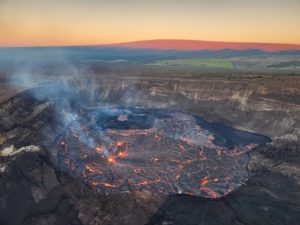
Chile , Puyehue-Cordon Caulle :
Special Report on Volcanic Activity (REAV), Los Lagos region, Puyehue-Cordon Caulle volcanic complex, September 8, 2023, 01:25 a.m. local time (mainland Chile).
The National Service of Geology and Mines of Chile (Sernageomin) publishes the following PRELIMINARY information, obtained using the monitoring equipment of the National Volcanic Monitoring Network (RNVV), processed and analyzed at the Southern Andean Volcanological Observatory ( Ovdas):
Today, September 8, 2023, at 00:55 and 00:56 local time (03:55 and 03:56 UTC), monitoring stations installed near the Puyehue-Cordon Caulle volcanic complex recorded two earthquakes associated with both rock fracturing and fluid dynamics in the volcanic system, (hybrid type).
The characteristics of earthquakes after their analysis are as follows:
ORIGINAL TIME: 00:55 local time (03:55 UTC)
LATITUDE: 40.514°S
LONGITUDE: 72.092°E
DEPTH: 2.4 km
LOCAL MAGNITUDE: 3.5
REDUCED DISPLACEMENT: 1338 cm2
ORIGINAL TIME: 00:56 local time (03:56 UTC)
LATITUDE: 40.516°S
LONGITUDE: 72.121°E
DEPTH: 2.5 km
LOCAL MAGNITUDE: 3.8
REDUCED DISPLACEMENT: 3484 cm2
OBSERVATIONS:
Following the occurrence of the event, 3 other hybrid type earthquakes, of lower energy, were recorded. Also, following the earthquakes, 7 volcano-tectonic events of low local magnitude were recorded. At the time of this report, the activity has ceased.
The technical volcanic alert remains at level Green.
Sources : Sernageomin.
Photo : Sergio Osses.
Colombia , Nevado del Ruiz :
Weekly bulletin on the activity of the Nevado del Ruiz volcano
From the monitoring of the activity of the NEVADO DEL RUIZ VOLCANO, the MINISTRY OF MINES AND ENERGY through the COLOMBIAN GEOLOGICAL SERVICE (SGC) reports that:
In the week of August 29 to September 4, 2023, the volcano showed unstable behavior with low to moderate levels and variations mainly in seismicity.
Seismic activity associated with fluid dynamics inside volcanic conduits decreased in the number of recorded earthquakes and in the seismic energy released, compared to the previous week. Despite this decrease, the recording of several seismic signals associated with the emission of gases and ash into the atmosphere or changes in relative temperature of the emitted materials continued. Both phenomena were confirmed by cameras used to monitor the volcano.
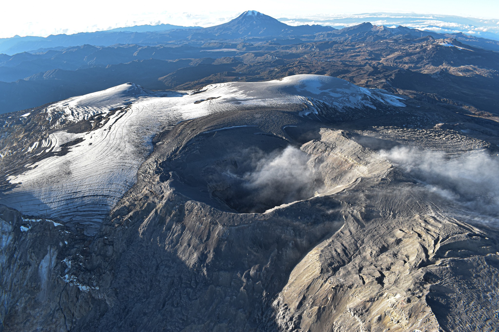
Seismicity linked to the fracturing of rocks inside the volcanic edifice increased in number of earthquakes recorded and seismic energy released, compared to the previous week. The earthquakes were located mainly in the northern sector and, to a lesser extent, in the southwest sector and in the Arenas crater of the volcano, at a distance of up to 10 km from the crater and at depths between less than 1 and 8 km with compared to the summit of the volcano. The seismic increase of September 2 stands out, in the afternoon, located between 2 and 3 km north of the crater and at depths between 3 and 4 km. This increase resulted in a significant number of earthquakes, but most of them were low energy. The maximum magnitude of the week was M1.4, corresponding to three earthquakes recorded during the rise, occurring at 1:19 p.m., 1:26 p.m. and 1:31 p.m.
Additionally, from satellite monitoring platforms, there are several reports of low-energy thermal anomalies detected at the crater floor.
The level of activity of the volcano remains at the level
YELLOW LEVEL (III): CHANGES IN THE BEHAVIOR OF VOLCANIC ACTIVITY
Source et photo : SGC
Vanuatu , Yasur :
19°32’0”S 169°26’30”E
Summit 1184ft (361m)
Current Volcano Alert Level: Level 2
Yasur volcano is continuing in the major unrest state. The Volcanic Alert Level remains at Level 2.
The Yasur volcanic activity is continuing at the major unrest state, consistent with the Volcanic Alert Level 2. Latest satellite data shows an increase in emissions of steam, gas, and ash on the crater.
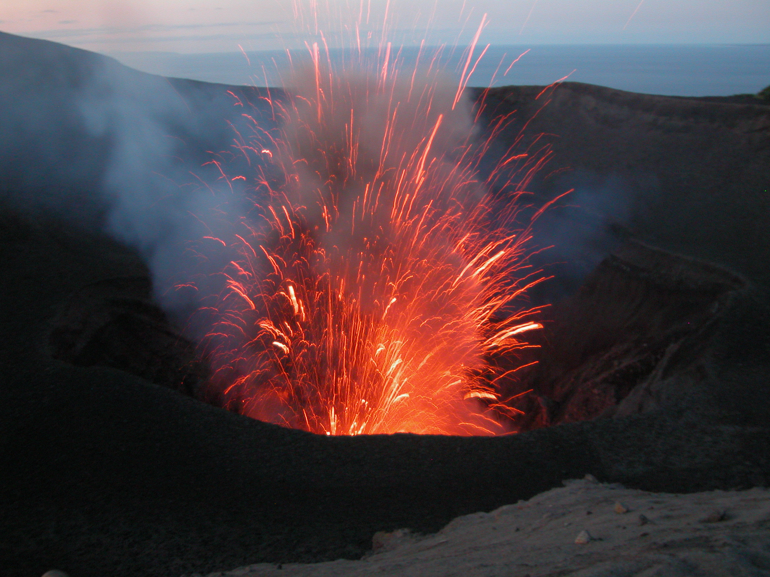
Some explosions remain intensified causing volcanic projectiles or bombs that fall in and/or around the summit crater. With this activity, some villages surrounding the volcano will expect ash fall impacts and/or acid rain depending on wind speed and direction and weather as reported by some inhabitants of White Sands this week. The Volcanic Alert Level is maintained at Level 2.
The public was reminded to not enter the restricted area within 600 m around the boundaries of the Permanent Exclusion Zone.
Source : Geohazard
Photo : Michel Massat
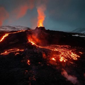
Kamchatka, Klyuchevskoy :
56.06 N, 160.64 E;
Elevation 4750 m (15580 ft)
Aviation Colour Code is YELLOW
The summit explosive-effusive eruption of the volcano continues. Ash explosions up to 6 km (19,700 ft) a.s.l. could occur at any time. Ongoing activity could affect low-flying aircraft.
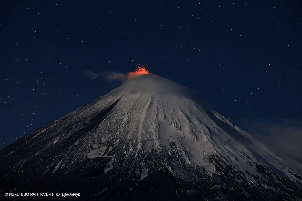
A summit explosive-effusive eruption of the volcano continues. Against the background of explosive activity of the Strombolian type (lava fountaining in the volcanic crater), lava flows continue to effuse along the Apakhonchichsky and Kozyrevsky chutes on the southeastern slopes of the volcano. Satellite data by KVERT showed a bright thermal anomaly over the volcano all week, excluding September 07 (dense cloudiness); plumes of resuspended ash extended for 120 km to the east of the volcano on September 03-05.
Source : Kvert
Photo : Yu. Demyanchuk, IVS FEB RAS, KVERT
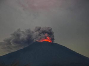
Ecuador , Sangay :
DAILY REPORT ON THE STATE OF THE SANGAY VOLCANO, Thursday September 7, 2023.
Information Geophysical Institute – EPN.
Surface activity level: High, Surface trend: No changes
Internal activity level: High, Internal trend: No changes
Seismicity: From September 6, 2023, 11:00 a.m. to September 7, 2023, 11:00 a.m.:
The number of seismic events recorded at the reference station over the past 24 hours is shown below. The level of seismic activity of the volcano remains high.
Explosion Event (EXP): 422.
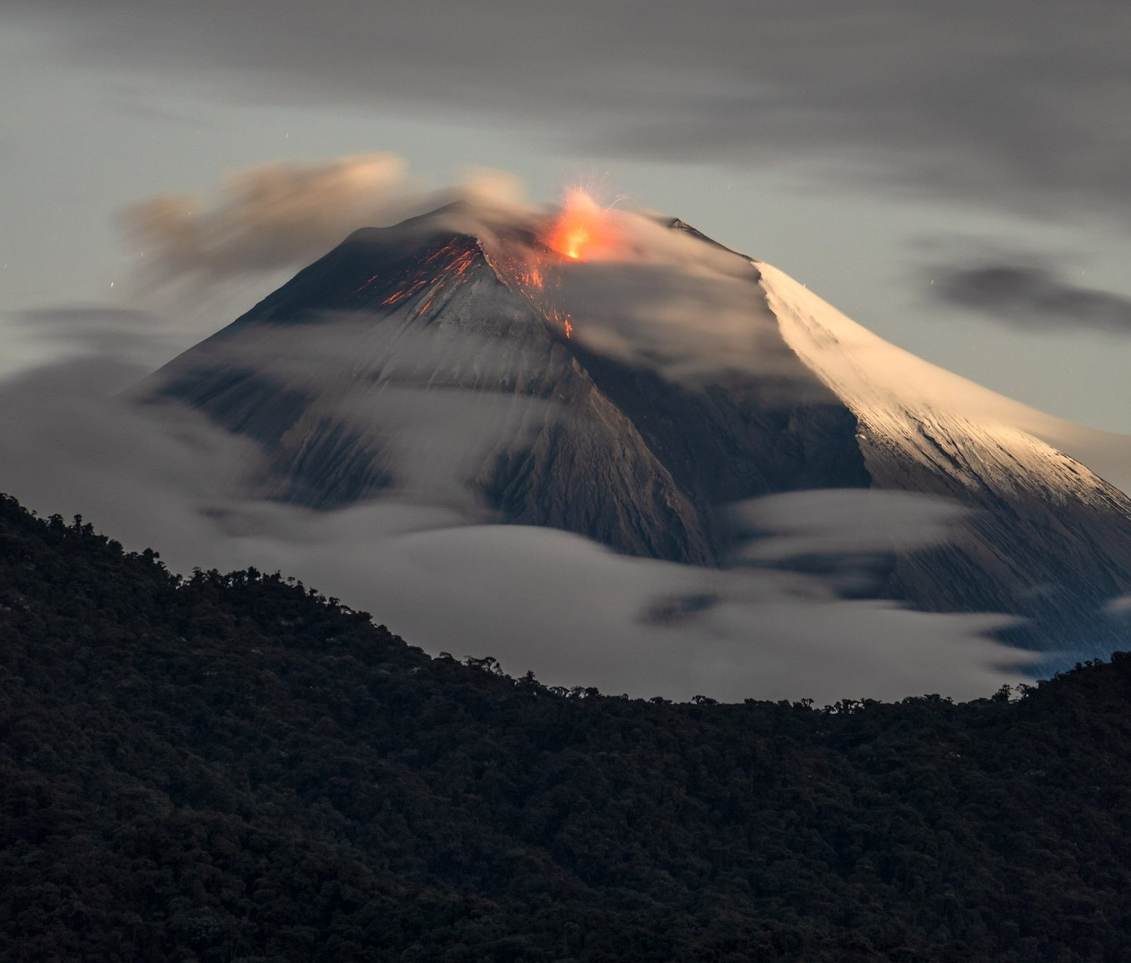
Precipitation/Lahars:
No rain was recorded in the volcano area which could generate mud and debris flows. **In the event of heavy rains, these could remobilize the accumulated materials, generating mud and debris flows which would descend the sides of the volcano and flow into adjacent rivers.
Emissions/ash column:
This morning, due to cloudiness in the area, only two gas and ash emissions were observed with heights less than 1,500 meters above the level of the crater, in the northwest and west direction.
Other monitoring parameters:
The FIRMS satellite system recorded 35 thermal anomalies, the MIROVA-MODIS satellite system recorded 2 high and 2 moderate thermal anomalies, while the MIROVAVIIRS satellite system recorded 4 high and 1 moderate thermal anomalies in the last 24 hours.
Observation:
Yesterday afternoon, the volcano remained cloudy. During the night of yesterday and early today, an incandescence was recorded at the crater and since this morning until the issuance of this report the volcano remains clear.
Alert level: Orange.
Source : IGEPN.
Photo : Robinsky