January 07 , 2023 .
Hawaii , Kilauea :
HVO/USGS Volcanic Activity Notice
Current Volcano Alert Level: WATCH
Previous Volcano Alert Level: WARNING
Current Aviation Color Code: ORANGE
Previous Aviation Color Code: RED
Issued: Friday, January 6, 2023, 8:15 AM HST
Source: Hawaiian Volcano Observatory
Notice Number: 2023/H16
Location: N 19 deg 25 min W 155 deg 17 min
Elevation: 4091 ft (1247 m)
Area: Hawaii
Volcanic Activity Summary:
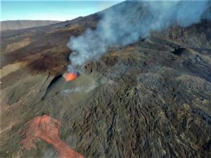
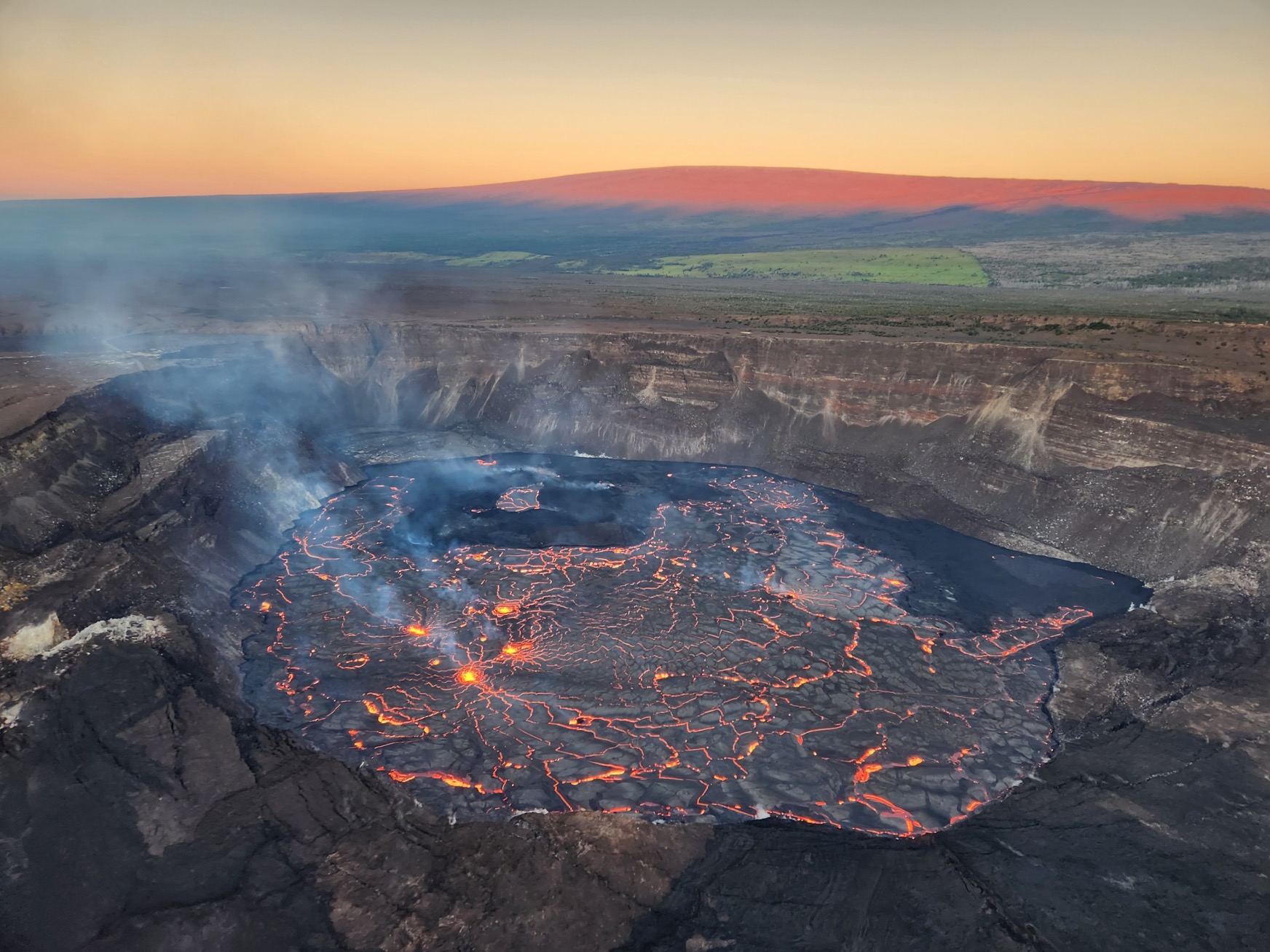
Kīlauea’s summit eruption continues and is confined to Halemaʻumaʻu crater within Hawai‘i Volcanoes National Park. HVO does not see any indication of activity migrating elsewhere on Kīlauea volcano and expects the eruption to remain confined to the summit region.
HVO is lowering Kīlauea’s volcano alert level from WARNING to WATCH because the initial high effusion rates are declining, and no infrastructure is threatened. HVO is lowering Kīlauea’s aviation color code from RED to ORANGE because there is currently no threat of significant volcanic ash emission into the atmosphere outside of the hazardous closed area within Hawai‘i Volcanoes National Park. Hazards associated with the eruption are limited and are described below.
HVO will continue to monitor this activity closely and report any significant changes in future notices.
Remarks:
Kīlauea volcano began erupting within Halema‘uma‘u crater at approximately 4:34 p.m. HST on January 5, 2023, following a couple weeks of intermittently elevated summit earthquake activity and gradual inflationary summit ground tilt. Earthquake activity increased dramatically at approximately 3 p.m. on January 5 with increased rates of inflationary ground deformation, prompting HVO to raise Kīlauea’s alert level and aviation color code to WATCH/ORANGE and then to WARNING/RED after the eruption began.
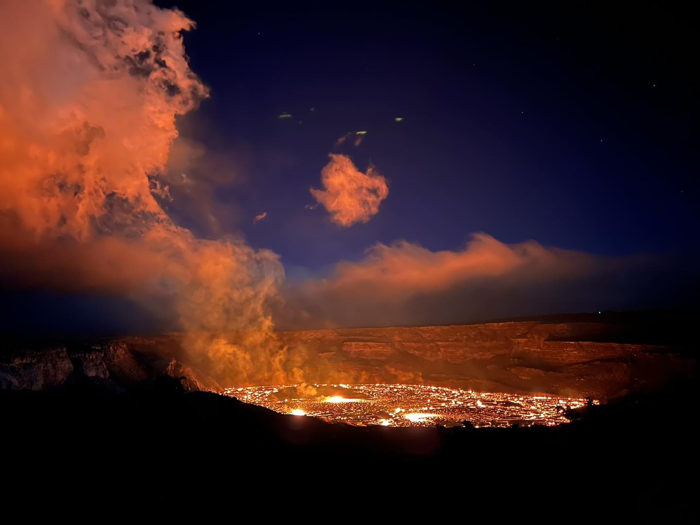
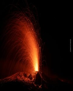
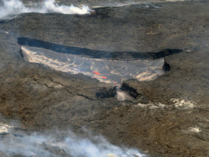
As of 7:30 a.m. HST this morning, January 6, several very minor fountains remain active in the central eastern portion of Halema‘uma‘u crater floor. The high initial effusion rates are declining rapidly as lava stored within the magma system over the past month is erupted. The fountains decreased in vigor overnight and are consistently about 5 meters (16 feet) high this morning. Lava flows have inundated much of the crater floor (which is nearly 300 acres or 120 hectares). The higher-elevation island that formed during the initial phase of the December 2020 eruption remains exposed, as well as a ring of older lava around the lava lake that was active prior to December 2022. This older lake has refilled from below with new lava. This morning, the depth of new lava remains at about 10 meters (32 feet) at the base of Halema‘uma‘u crater.
Summit tilt switched from inflation to deflation around 5 p.m. HST yesterday, January 5, and that trend continues this morning. Following the eruption onset, summit earthquake activity greatly diminished and eruptive tremor (a signal associated with fluid movement) resumed. Volcanic gas emissions in the eruption area are elevated.
Source : HVO.
Photos : USGS , Epiclava.
Indonesia , Merapi :
Report on the activity of Mount Merapi from December 30, 2022 to January 05, 2023, Published on January 06, 2023
RESULTS OF OBSERVATIONS
Visual
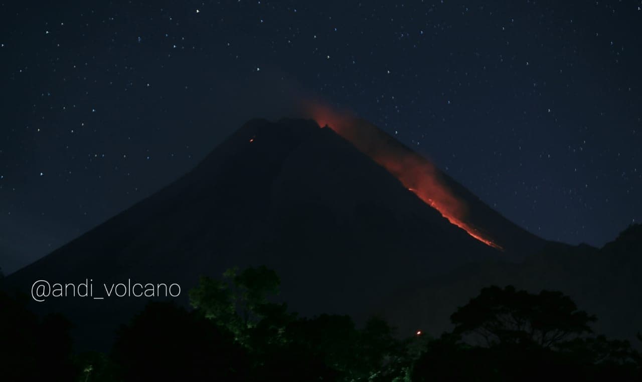
The weather around Mount Merapi is usually sunny in the morning and afternoon, while the evening is foggy. White smoke, thin to medium thickness, low pressure and 30 m high was observed from the Mount Merapi observation post of Kaliurang on December 31, 2022 at 06:40 WIB.
This week, there were 1 southwestward lava avalanches with a slip distance of 900 m. Lava avalanches were observed up to 8 times towards the South-West (the first towards Kali Bebeng then Kali Sat/Putih) with a maximum slip distance of 1,500 m.
– There is no significant morphological change in the South-West dome and the central dome. The volume of the South-West dome is calculated fixed, i.e. 1,616,500 m3, while for the middle dome it is 2,772,000 m3.
Seismicity
This week, the seismicity of Mount Merapi showed:
32 deep volcanic earthquakes (VTB)
589 Deep Volcanic Earthquakes (VTA),
229 avalanche earthquakes (RF),
1 hot cloud avalanche earthquakes (APG),
4 tectonic earthquakes (TT).
78 multi-phase (MP) earthquakes
The intensity of this week’s seismicity is still quite high.
Deformation
The Mount Merapi deformation that was monitored using EDM and GPS this week showed a shortening rate of 0.6 cm/day.
Rain and lahars:
This week, there was rain at the Badaban observation post with a rain intensity of 20 mm/h for 280 minutes on January 5, 2023. No increase in flow is reported in the streams originating from the Merapi.
Conclusion
Based on the results of visual and instrumental observations, it is concluded that:
-The volcanic activity of Mount Merapi is still quite high in the form of effusive eruption activity. The state of the activity is defined at the « SIAGA » level.
Source : BPPTKG
Photo : Andi volcanist
Indonesia , Kawah Ijen / G. Marapi :
The eruptive activity of G. Ijen since 1900 is in the form of phreatic eruptions from crater lakes. In 2018, there were also three gas explosions (CO2 explosions), namely January 10, 2018, February 19, 2018 and March 21, 2018, which was a fairly large gas explosion followed by a flow of gas along the Banyu Pait river valley until reaching a distance of more than 7 km. The last increase in activity occurred on January 17, 2020, in the form of an increase in the number of shallow volcanic earthquakes.
The latest developments in the activity of G. Ijen until January 5, 2023 at 24:00 WIB are as follows:
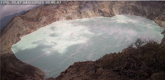
There was an increase in the temperature of the water of the crater lake from 16oC in December 2022 to 45.6oC on January 5, 2023. This indicates a warming of the water of the crater lake of G. Ijen.
- The seismicity of G. Ijen since January 1, 2023 is still dominated by surface earthquakes, namely shallow volcanic earthquakes recorded 56 times and emission earthquakes recorded 36 times. The presence of earthquakes at shallow depth indicates the accumulation of pressure accompanied by the process of pressure release. This also causes an increase in the permeability of the rocks at the bottom of the G. Ijen crater, which facilitates the movement of volcanic gases to the surface.
Fine white crater smoke was observed at a height of approximately 50 to 200 meters above the summit.
The potential danger that can be caused by the volcanic activity on Mount Ijen currently is the emergence of high concentrations of volcanic gases around the crater, derived from the solfatara activity on the wall of the crater of Ijen and also the diffusion of volcanic gases from the interior of the crater to the surface; Phreatic eruptions occur in the form of gas jets from the crater lake. Phreatic eruptions can occur without being preceded by increased activity both visual and seismic.Regarding the activity of G. Ijen at activity level I (normal), it is recommended:People around G. Ijen and visitors/tourists/miners should not approach the crater rim or descend and approach the bottom of G. Ijen crater, and not stay overnight in the area of G. Ijen Ijen within a radius of 500 meters around the crater.
———————————————————————————————————————
The volcanic activity of G. Marapi has fluctuated since January 2022, and the level of activity is level II (WASPADA) since August 3, 2011.
We transmit the latest developments in the activity of G. Marapi until January 7, 2023 at 08:00 WIB as follows:
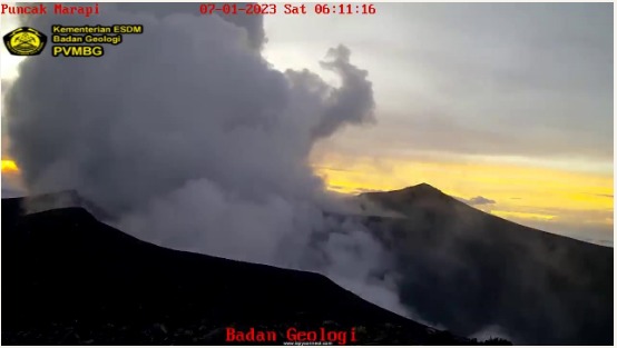
An explosive eruption occurred on January 7, 2023 at 06:11 WIB with a column of ash 300 meters above the summit. The current threat of danger is an eruption of ash accompanied by an ejection of material likely to affect an area with a radius of 3 km around the center of the eruption of the Verbeek crater.
This eruption was preceded by an increase in deep volcanic earthquakes on December 25, 2022 which were recorded 13 times and inflation in the data from the measuring station’s tiltmeter
Seismic data from December 26, 2022 to January 6, 2023 recorded 11 emission earthquakes, 9 « Tornillo » type earthquakes, 3 shallow volcanic earthquakes, 10 deep volcanic earthquakes and 30 earthquakes local tectonics.
Based on the results of observations, analysis of visual and instrumental data until January 7, 2023 at 08:00 WIB, the activity level of G. Marapi is still at level II (Alert).
The recommendations for this Tier II (Alert) activity level are:
Communities around Mount Marapi and visitors/tourists should not carry out activities/approach Mount Marapi within 3 km of the crater/summit, considering that the crater is the center of the eruption and the source of volcanic gases that can be harmful to life.
Source et photos : PVMBG.
Kamchatka , Sheveluch :
VOLCANO OBSERVATORY NOTICE FOR AVIATION (VONA)
Issued: January 07 , 20230107/0455Z
Volcano: Sheveluch (CAVW #300270)
Current aviation colour code: ORANGE
Previous aviation colour code: orange
Source: KVERT
Notice Number: 2023-07
Volcano Location: N 56 deg 38 min E 161 deg 18 min
Area: Kamchatka, Russia
Summit Elevation: 3283 m (10768.24 ft), the dome elevation ~2500 m (8200 ft)
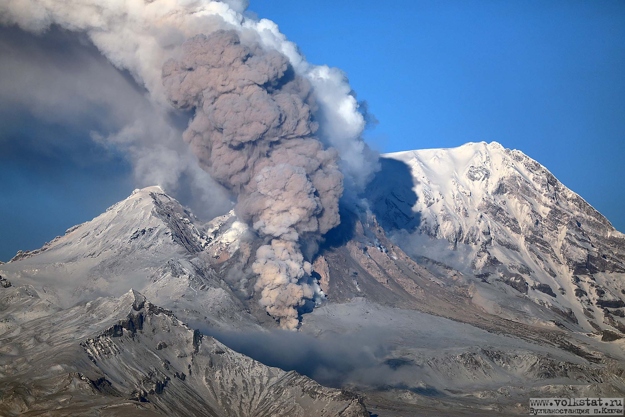
Volcanic Activity Summary:
The growth of the lava dome continues, a strong fumarole activity, an incandescence of the lava dome, explosions, and hot avalanches accompanies this process. Explosions sent ash up to 7-7.5 km a.s.l., an ash plume moved to the west of the volcano.
The extrusive eruption of the volcano continues. Ash explosions up to 10-15 km (32,800-49,200 ft) a.s.l. could occur at any time. Ongoing activity could affect international and low-flying aircraft.
Volcanic cloud height:
7000-7500 m (22960-24600 ft) AMSL Time and method of ash plume/cloud height determination: 20230107/0442Z – Video data
Other volcanic cloud information:
Distance of ash plume/cloud of the volcano: 10 km (6 mi)
Direction of drift of ash plume/cloud of the volcano: W
Time and method of ash plume/cloud determination: 20230107/0450Z – Video data
Source : Kvert.
Photo : volkstat ru ( archive).