May 28 , 2023 .
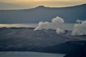
Colombia , Nevado del Ruiz :
Manizales, May 27, 2023 11:00 a.m.
Regarding the monitoring of the activity of the NEVADO DEL RUIZ VOLCANO, the MINISTRY OF MINES AND ENERGY through the COLOMBIAN GEOLOGICAL SERVICE (SGC) informs that:
Since 9:00 a.m. yesterday (May 26) until the time of publication of this bulletin, seismicity related to the movement of fluids inside volcanic conduits has increased in the number of recorded earthquakes and maintained seismic energy levels. , compared to May 25.
This type of seismicity was mainly characterized by the occurrence of small earthquakes, located in the Arenas crater, which are associated with the activity of the lava dome (bulge or mound) located at the bottom of the crater. Some of the seismic signals were associated with pulsating ash emissions confirmed by web cameras used for volcanic monitoring.

On the other hand, the seismic activity associated with the fracturing of the rocks continued inside the volcanic edifice recorded since May 24 in the northeast sector of the volcano, at a maximum distance of 4 km from the Arenas crater and at depths between 4 and 6 km. This seismicity presented a decrease in the number of earthquakes and similar seismic energy compared to May 25. Seismicity has also been recorded occasionally in the Arenas crater. The maximum magnitude recorded was 1.4 ML, corresponding to the 2:03 p.m. earthquake, located 4 km northeast of the Arenas crater, and at a depth of approximately 5 km from the summit of the volcano.
The level of activity of the volcano remains at the ORANGE LEVEL of activity or (II): PROBABLE ERUPTION IN TERM OF DAYS OR WEEKS
Source and photo : Ingeominas.
El Salvador , San Miguel ( Chaparrastique) :
This May 27 at 4:47 p.m., an emission of gas and ash was observed from the central crater of the San Miguel volcano, since the gradual increase in seismicity records from the volcano that began on April 23.
Since the last Environment report, the Civil Protection authorities have recommended that the population maintain the two-kilometre security perimeter around the volcano.
The Director General of Civil Protection, Luis Amaya, warned this Saturday of an increase in degassing and seismicity on the San Miguel volcano from the latest report from the Ministry of the Environment. He mentioned that the emanation registered the presence of ash in the La Morita canton, in the municipality of San Jorge.
That day in the afternoon more precisely at 4:47 in the afternoon, we had a gas emanation with the presence of ashes which could be verified in the canton of La Morita in the urban area of the municipality of San Jorge and other surrounding areas.
Likewise, he said that they have carried out constant monitoring and are in communication with the municipal commissions of San Jorge, Chinameca and San Juan Rafael Oriente and the municipal commissions.
“We have maintained constant surveillance and we are in communication with our municipal commissions of San Jorge, Chinameca and San Rafael Oriente, and the municipal commissions in order to safeguard the lives of local families,” he added.
He added that the degassing that was presented is like the one that already took place in December 2022 and last January.
Source : Diario el mundo .
Photo : Marn
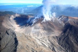
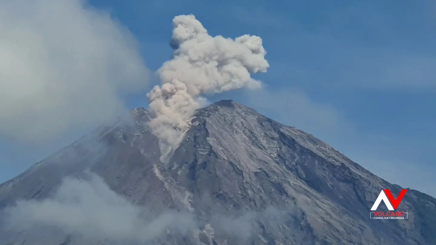
Indonesia , Semeru :
VOLCANO OBSERVATORY NOTICE FOR AVIATION – VONA
Issued : May 28 , 2023
Volcano : Semeru (263300)
Current Aviation Colour Code : ORANGE
Previous Aviation Colour Code : orange
Source : Semeru Volcano Observatory
Notice Number : 2023SMR197
Volcano Location : S 08 deg 06 min 29 sec E 112 deg 55 min 12 sec
Area : East java, Indonesia
Summit Elevation : 11763 FT (3676 M)
Volcanic Activity Summary :
Eruption with volcanic ash cloud at 03h04 UTC (10h04 local).
Volcanic Cloud Height :
Best estimate of ash-cloud top is around 13363 FT (4176 M) above sea level or 1600 FT (500 M) above summit. May be higher than what can be observed clearly. Source of height data: ground observer.
Other Volcanic Cloud Information :
Ash cloud moving from southwest to west. Volcanic ash is observed to be gray. The intensity of volcanic ash is observed to be thick.
Remarks :
Eruption recorded on seismogram with maximum amplitude 22 mm and maximum duration 100 second.
Source : Magma Indonésie.
Photo : Andi volcanist
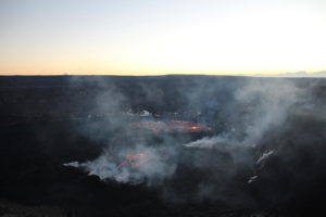
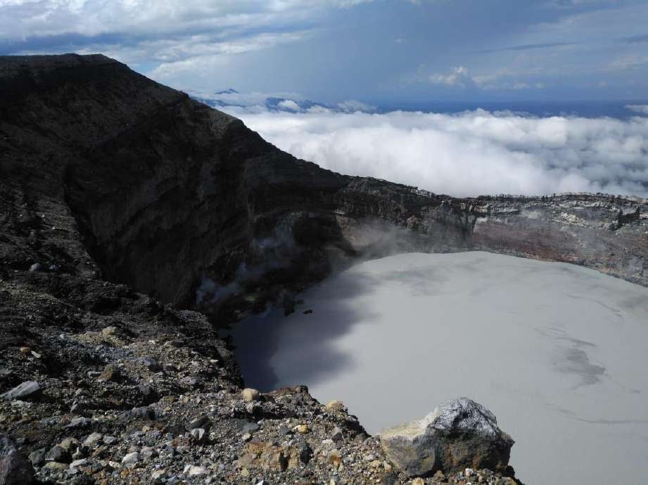
Costa Rica , Rincon de la Vieja :
Latitude: 10.83
Longitude:-85.324
Altitude: 1,916 meters
Observed activity:
Over the past 24 hours, several eruptions have been detected (1:57 p.m., 11:48 p.m. on May 26, 2023; 2:21 a.m. and 6:32 a.m. today). After the eruption recorded at 10:48 p.m. yesterday, the volcanic tremor broke up, manifesting intermittently. Geodetic observations show a slight extension of the base of the volcano and a slight uplift of the summit. The concentration of volcanic gases is maintained with values similar to those recorded. A considerable drop in the level of the lake has been detected.
Environmental conditions:
The winds are weak and mainly in the West and the summit is clear this morning.
UPDATE / ERUPTION REPORT – OVSICORI-UNA
Plume height (above crater): 13120 feet. (4000 meters)
Plume observation source: seismic recording, infrasound and webcam.
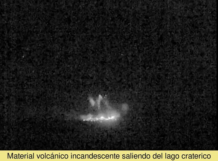
Observed activity:
An energetic eruption was observed which projected incandescent materials and generated a large lahar on the northern flank of the volcano. For the moment, the lahar has been reported in the Pénjamo river but it cannot be excluded that other rivers have been affected.
The plume exceeded the field of view of the webcam so the height is at least 3500m but possibly 4000m.
Plume composed mainly of water vapor, however incandescent materials (eg hot rocks) were observed in the first seconds of the eruption.
There was a slight tremor.
Activity Level: Warning
Source : Ovsicori .
Photos : Waldo Taylor / ICE. Ovsicori.
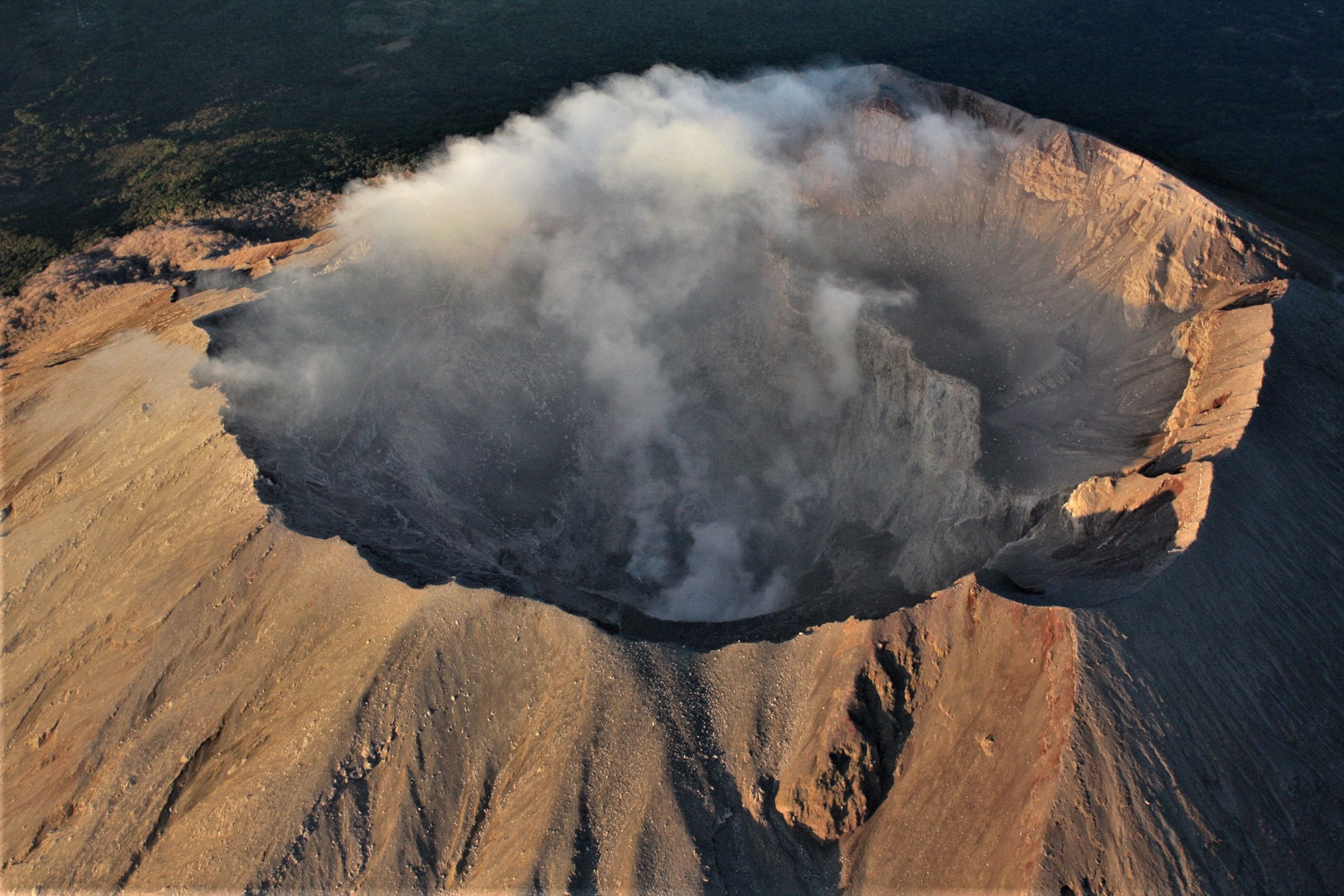
Mexico , Popocatepetl :
During the last 24 hours, according to the monitoring systems of the Popocatépetl volcano, 19 exhalations and 1,411 minutes of high frequency tremors of low to moderate amplitude have been detected, associated with the continuous emission of gas, vapor of water and ash, as well as on occasions of ejection of incandescent fragments a short distance from the crater.
7:00 p.m. update
For now, the high frequency, low amplitude tremor signal continues. A persistent emission of water vapor, other volcanic gases and ash was observed, heading towards the Southeast. Any changes in activity will be reported in a timely manner.
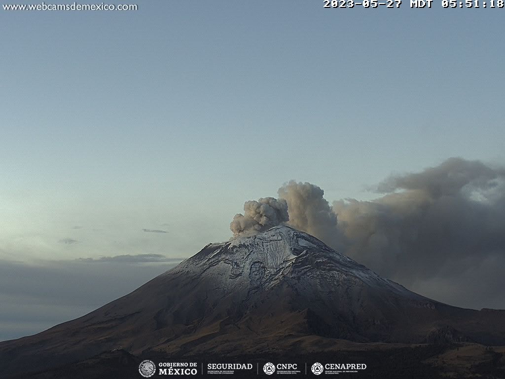
The volcanic alert traffic light is in YELLOW PHASE 3.
CENAPRED insistently reiterates the recommendation NOT TO CLIMB to the crater of the volcano, because there is the possibility of explosions, as we have seen on several occasions in the past, involving the emission of incandescent fragments. Therefore, he is required to respect the exclusion radius of 12 km. Also, in heavy rain, stay away from the bottom of ravines due to the danger of mudslides and debris.
Source and photo : Cenapred.