January 13 , 2023 .
Hawaii , Kilauea :
Thursday, January 12, 2023, 9:15 AM HST (Thursday, January 12, 2023, 19:15 UTC)
19°25’16 » N 155°17’13 » W,
Summit Elevation 4091 ft (1247 m)
Current Volcano Alert Level: WATCH
Current Aviation Color Code: ORANGE
Activity Summary:
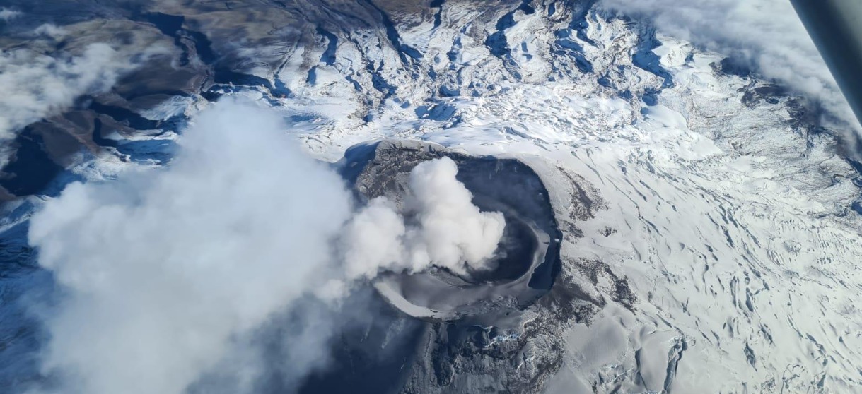
The summit eruption of Kīlauea Volcano, within Halemaʻumaʻu crater, continued over the past 24 hours. All recent eruptive activity has been confined to the crater. No significant changes have been observed at the summit or in either rift zone.
Halemaʻumaʻu Lava Lake Observations:
Eruption of lava from vents on the central eastern portion of Halemaʻumaʻu crater floor continued over the past 24 hours. Activity is concentrated in a large lava lake in the eastern half of the crater, as well as a smaller area of lava within the basin in the western half of the crater that was the focus of activity in 2021–2022. The active lava lake in the eastern half of the crater has one dominant fountain, measured at 6-7 yards (meters) high. The eastern lava lake had an area of approximately 30 acres (12 hectares) on January 10, and the surface area has fluctuated slightly over the past 24 hours.
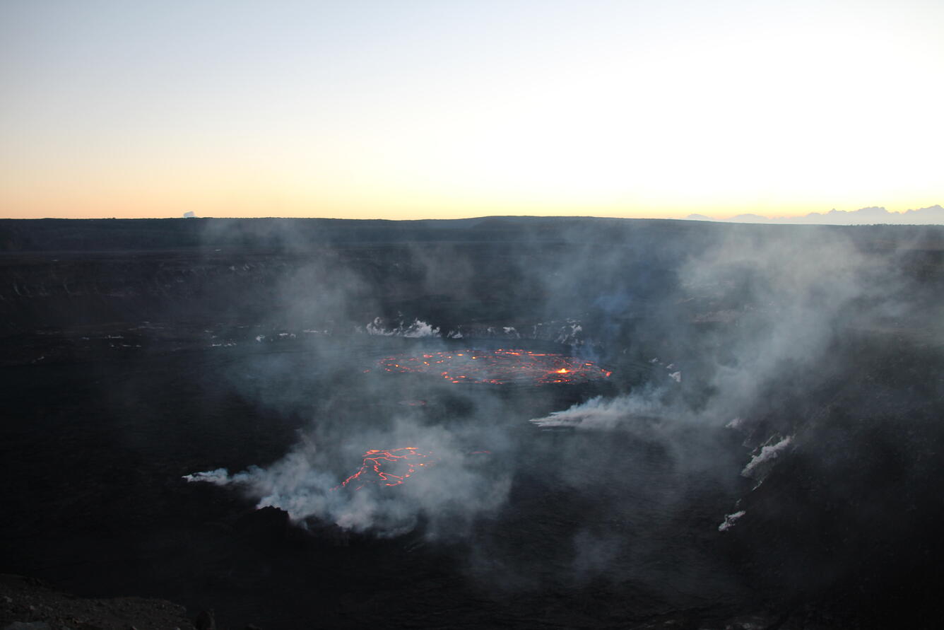
View of the continuing eruption within Halema‘uma‘u at the summit of Kīlauea at dawn looking eastwards on January 11, 2023. Lava is erupting within the southeast portion of the crater (middle) and within the basin in the western half of the crater that was the focus of activity in 2021–2022 (center bottom). The southeast portion has one dominant dome fountain, visible at bright yellow in this photo.
Summit Observations:
Over the past 24 hours, summit tiltmeters recorded inflation until yesterday afternoon, with no significant changes since then. Volcanic tremor remains above background levels. A sulfur dioxide (SO2) emission rate of approximately 3,500 tonnes per day (t/d) was measured on January 9, 2023.
Rift Zone Observations:
No unusual activity has been noted along the East Rift Zone or Southwest Rift Zone; low rates of ground deformation and seismicity continue along both. Measurements from continuous gas monitoring stations downwind of Puʻuʻōʻō in the middle East Rift Zone remain below detection limits for SO2, indicating that SO2 emissions from Puʻuʻōʻō are negligible.
Source : HVO
Photo : USGS / N. Deligne.
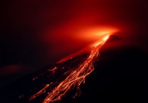
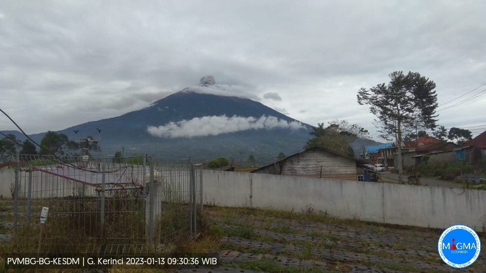
Indonesia , Kerinci :
An eruption of Mount Kerinci occurred on Friday January 13, 2023 at 09:31 WIB with an ash column height observed at ± 400 m above the summit (± 4205 m above sea level). The ash column was observed to be gray with a thick intensity, oriented to the north. At the time of writing this report, the eruption was still ongoing.
VOLCANO OBSERVATORY NOTICE FOR AVIATION – VONA
Issued : January 13 , 2023
Volcano : Kerinci (261170)
Current Aviation Colour Code : ORANGE
Previous Aviation Colour Code : orange
Source : Kerinci Volcano Observatory
Notice Number : 2023KER004
Volcano Location : S 01 deg 41 min 49 sec E 101 deg 15 min 50 sec
Area : Jambi, West Sumatra, Indonesia
Summit Elevation : 12176 FT (3805 M)
Volcanic Activity Summary :
Eruption with volcanic ash cloud at 02h31 UTC (09h31 local).
Volcanic Cloud Height :
Best estimate of ash-cloud top is around 13456 FT (4205 M) above sea level or 1280 FT (400 M) above summit. May be higher than what can be observed clearly. Source of height data: ground observer.
Other Volcanic Cloud Information :
Ash cloud moving to north. Volcanic ash is observed to be gray. The intensity of volcanic ash is observed to be thick.
Remarks :
Eruption and ash emission is continuing.
Source et photo : Magma Indonésie.
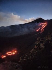
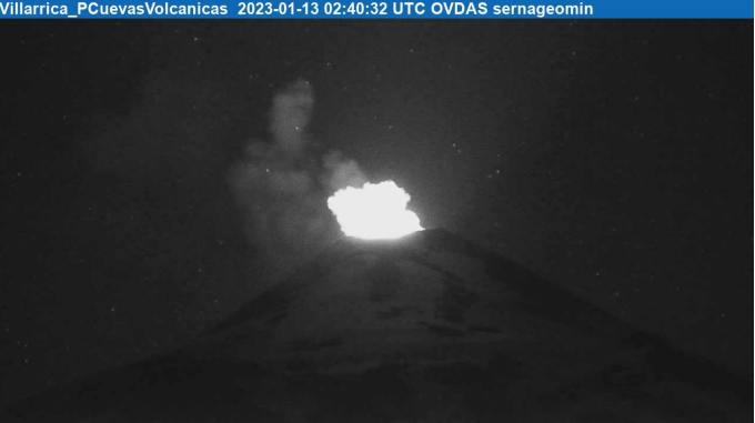
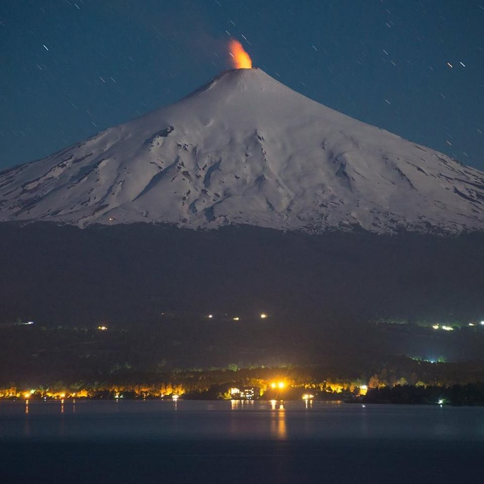
Chile , Villarica :
Special Report on Volcanic Activity (REAV), La Araucanía and Los Ríos regions, Villarrica volcano, January 13, 2023, 00:00 a.m. local time (mainland Chile)
The National Geology and Mining Service of Chile (Sernageomin) announces the following PRELIMINARY information, obtained through the monitoring equipment of the National Volcanic Monitoring Network (RNVV), processed and analyzed at the Observatory of Volcanoes of the Southern Andes (Ovdas):
On Thursday January 12, 2023, at 23:40 local time (02:40 UTC January 13, 2023), monitoring stations installed near the Villarrica volcano recorded an earthquake associated with fluid dynamics within the volcanic system. (type LP).
The characteristics of the earthquake, after its analysis, are as follows:
ORIGINAL TIME: 23:40 local time (02:40 UTC Jan 13, 2023)
REDUCED DISPLACEMENT: 52.21 (cm*cm)
ACOUSTIC SIGNAL: 7.2 Pascals (Pa) reduced to 1 km
The characteristics of this activity are as follows:
MAXIMUM HEIGHT OF THE COLUMN: 1000 meters above the point of emission
DIRECTION OF DISPERSION: Southeast (SE).
COMMENTS:
When this report was issued, the IP cameras recorded a nocturnal incandescence associated with the column of gas.
The volcanic technical alert is maintained at the Yellow level.
Source : Sernageomin .
Photos : Sernageomin , Martini Fotografía.
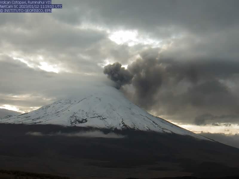
Ecuador , Cotopaxi :
DAILY REPORT OF THE STATE OF COTOPAXI VOLCANO, Thursday January 12, 2023.
Information Geophysical Institute – EPN.
Surface activity level: Moderate, Surface trend: Ascending.
Internal activity level: Moderate, Internal trend: No change.
Seismicity: From January 11, 2023, 11:00 a.m. to January 12, 2023, 11:00 a.m.:
The volcano’s seismic array remained operational for the past 24 hours.
Emission Tremor (TREMI) 10
Long Period (LP): 45
Volcano tectonics ( VT): 1
Rains / Lahars:
In the afternoon of yesterday, there were rains in the area of the volcano.
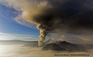
Emission / Ash Column:
Emissions of steam, gas and ash were observed with a maximum height of 600 meters above the level of the crater in a southeast direction. The Washington VAAC reported 2 emissions with a height of 200 meters above crater level in a west and southwest direction.
Other Monitoring Parameters:
No thermal anomalies were recorded in the satellite systems in the past 24 hours.
Observation:
At the moment, the area is cloudy. The SNGRE reports a slight ash fall in Mulaló, Macaló Grande sector; Reports of sulfur odors are also received in the towns of Ticatilín and Control Caspi in the Cotopaxi National Park.
Alert level: Yellow.
Sources et photos : IGEPN.
Guatemala , Fuego :
Activity:
The Fuego OVFGO volcano observatory reports white degassing that reaches a height of 200 meters above the crater. There were 3 to 5 low and moderate explosions per hour, following the explosions ash columns were generated 4,600 to 4,900 meters above sea level (15,092 to 16,076 feet) which spread over 15 km in a North-North-East direction.
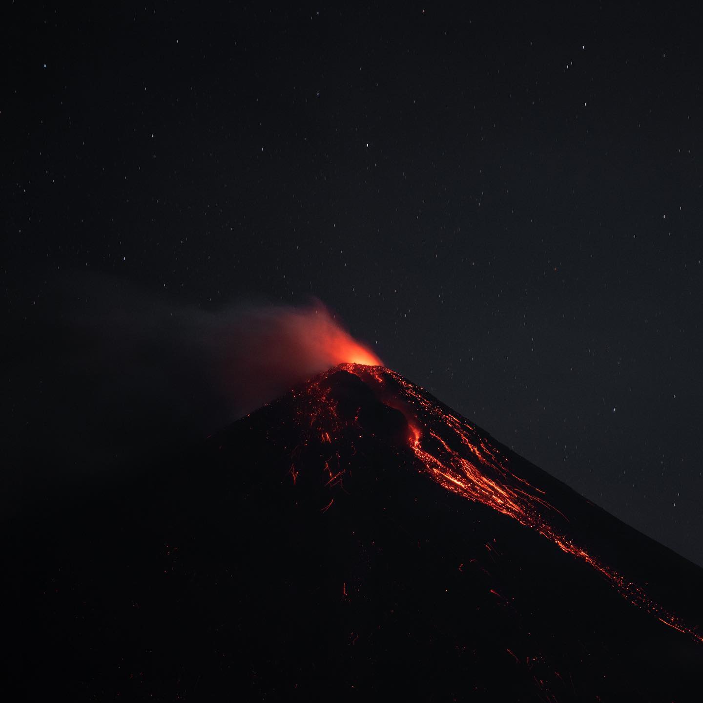
Incandescent pulses are observed 250 to 300 meters above the crater, weak and moderate avalanches have also been observed in the direction of the Ceniza, Santa Teresa, Las Lajas and Taniluyá ravines. Weak rumblings are reported which generate weak shock waves which vibrate the roofs and windows of houses near the volcano. Following the explosions, ashfall is reported in areas of Alotenango and neighboring communities.
Source : Insivumeh .
Photo : Diego Rizzo.