May 27 , 2023.
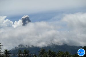
Mexico , Popocatepetl :
May 26, 11:00 a.m. (May 26, 5:00 p.m. GMT)
During the last 24 hours, according to the monitoring systems of the Popocatépetl volcano, 59 exhalations accompanied by water vapor, volcanic gases and ash have been detected.
1,101 minutes of high frequency tremors of low to moderate amplitude were recorded, associated with the continuous emission of gas, water vapor and ash, as well as the expulsion of incandescent materials at a short distance from the volcano. Additionally, 138 minutes of exhalation footage was recorded.
A slight fall of ash was recorded in the municipality of Tetela del Volcán at 03:30.

Civil protection.
According to the analysis of the images taken during an overflight of the Popocatépetl volcano by the Secretary of the Navy carried out on the morning of May 26, the presence of a lava dome was not observed, but it was appreciated that the main crater has been significantly filled by emitted fragmented magmatic material. Likewise, activity over the past three days has consisted of the emission of ash and incandescent fragments associated with the recording of tremors of fluctuating duration and amplitude.
It was concluded that the most probable scenario in the short term is that an activity similar to that which occurred recently continues, characterized by the appearance of tremors with high frequency and variable amplitude; some minor to moderate and sometimes significant explosions, and ash emissions that can reach populations further away than those already observed, as well as the expulsion of incandescent fragments within the exclusion radius of 12 kilometers.
The Scientific Advisory Committee of the National Civil Protection System of the Popocatépetl volcano will remain in permanent session.
At the time of this report, an emission of water vapor, volcanic gases and light amounts of ash is observed in a South-South-East direction.
The volcanic alert traffic light remains YELLOW PHASE 3.
May 26, 7:00 p.m. (May 27, 5:00 p.m. GMT) Update
The tremor signal continues, while its amplitude continues to decrease. The prevailing weather conditions in the region do not allow visibility towards the summit of the volcano. Sporadically, it was possible to observe an emission of water vapor, other volcanic gases and a low ash content directed towards the South-South-East. Any changes in activity will be reported in a timely manner.
Source : Cenapred.
Photos : Erik Gómez Tochimani Fotógrafo , volcan popocatepetl.
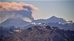
Hawaii , Kilauea :
Thursday, May 26, 2023, 8:27 AM HST (Thursday, May 26, 2023, 18:27 UTC)
19°25’16 » N 155°17’13 » W,
Summit Elevation 4091 ft (1247 m)
Current Volcano Alert Level: ADVISORY
Current Aviation Color Code: YELLOW
Activity Summary:
Kīlauea volcano is not erupting. Kīlauea summit is currently exhibiting signs of heightened unrest. Summit seismicity remains elevated. No unusual activity has been noted along Kīlauea’s East Rift Zone or Southwest Rift Zone.
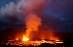
Halemaʻumaʻu Lava Lake Observations:
No active lava has been observed over the past day.
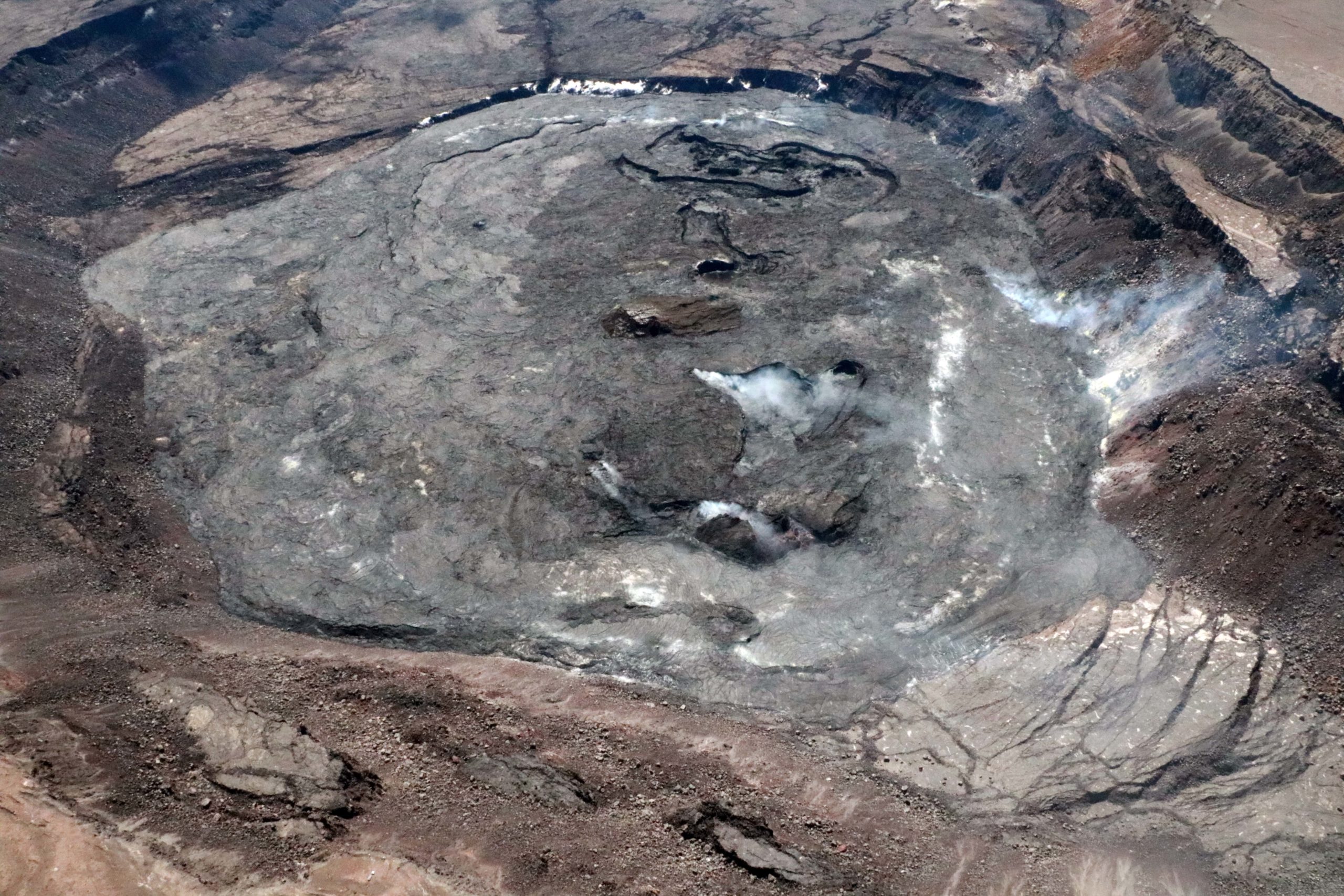
This aerial view, looking east across Halema‘uma‘u crater floor, shows the complex features formed during recent Kīlauea summit eruptions. The basin of the lava lake from the September 2021-December 2022 eruption is visibly steaming near the base of the photo, the island that formed during the December 2020-May 2021 eruption is brown-colored and visible in the center of the photo, and the basin that formed during the most recent January-March 2023 eruption is the complex basin-feature visible near the top of the image.
Summit Observations:
Summit tiltmeters recorded somewhat variable tilt over the past day, however recent rates of deformation have been high. Earthquake rates remain elevated beneath Kīlauea summit and Nāmakanipaio, with over 60 earthquakes in the past day. Most of them have been smaller than magnitude-2 and not reported felt. Both deformation and seismicity rates have been high for several months; elevated beyond the rates observed preceding the January 5, 2023 summit eruption. The most recent sulfur dioxide (SO2) emission rate of approximately 90 tonnes per day was measured on May 24, 2023.
Rift Zone Observations:
No unusual activity has been noted along the East Rift Zone or Southwest Rift Zone; steady rates of ground deformation and seismicity continue along both. Measurements from continuous gas monitoring stations in the middle East Rift Zone—the site of 1983–2018 eruptive activity—remain below detection limits for SO2.
Source : HVO.
Photo : USGS / K. Mulliken.
Indonesia , Merapi :
Report on the activity of Mount Merapi from May 15, 2023 to May 25, 2023, Published on May 26, 2023
RESULTS OF OBSERVATIONS
Visual
The weather around Mount Merapi is usually sunny in the morning and afternoon, while the evening is foggy. White, fine to thick smoke, low to medium pressure and 200 m high was observed from the Mount Merapi observation post in Ngepos on May 25, 2023 at 08:00.
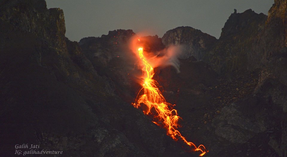
This week, lava avalanches were observed 236 times towards the South-West (upstream of Kali Bebeng and Kali Boyong) with a maximum slip distance of 2000 m. The sound of the avalanches was heard 25 times from Babadan post with low to moderate intensity.
On the Southwest dome, morphological changes have been observed due to lava avalanches. For the central dome, no significant morphological change was observed. Based on the results of a drone survey on May 17, 2023, the measured volume of the Southwest dome was 2,372,800 m3 and the central dome was 2,337,300 m3.
Seismicity
This week, the seismicity of Mount Merapi showed:
26 deep volcanic earthquakes (VTB),
876 avalanche earthquakes (RF),
9 tectonic earthquakes (TT).
72 multi-phase (MP) earthquakes
2 low frequency (LF) earthquakes.
In general, the intensity of seismicity this week is higher than last week.
Deformation
Mount Merapi’s deformation that was monitored using EDM and GPS this week showed a shortening rate of 0.01 cm/day.
Rain and lahars:
This week, there was no rain at the Mount Merapi observation post and no additional flows were reported in the rivers that descend from Mount Merapi.
Conclusion
Based on the results of visual and instrumental observations, it is concluded that:
-The volcanic activity of Mount Merapi is still quite high in the form of effusive eruption activity. The state of the activity is defined at the « SIAGA » level.
The current danger potential is in the form of lava avalanches and hot clouds in the South-South-West sector comprising the Boyong River for a maximum of 5 km, the Bedog, Krasak, Bebeng rivers for a maximum of of 7 km. In the South-East sector, it includes the Woro River for a maximum of 3 km and the Gendol River for 5 km. While the ejection of volcanic material in the event of an explosive eruption can reach a radius of 3 km from the summit.
Source : BPPTKG
Photo : Yohannes Tyas Galih Jati
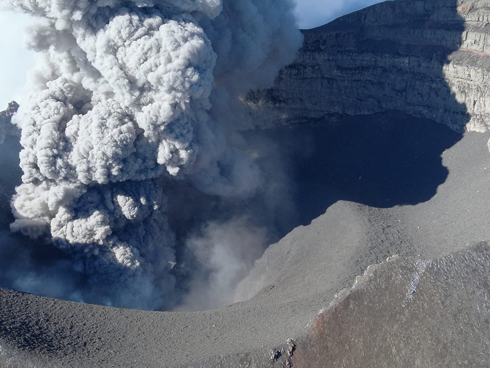
Kamchatka , Sheveluch :
VOLCANO OBSERVATORY NOTICE FOR AVIATION (VONA)
Issued: May 27 , 2023
Volcano: Sheveluch (CAVW #300270)
Current aviation colour code: ORANGE
Previous aviation colour code: orange
Source: KVERT
Notice Number: 2023-71
Volcano Location: N 56 deg 38 min E 161 deg 18 min
Area: Kamchatka, Russia
Summit Elevation: 3283 m (10768.24 ft), the dome elevation ~2500 m (8200 ft)
Volcanic Activity Summary:
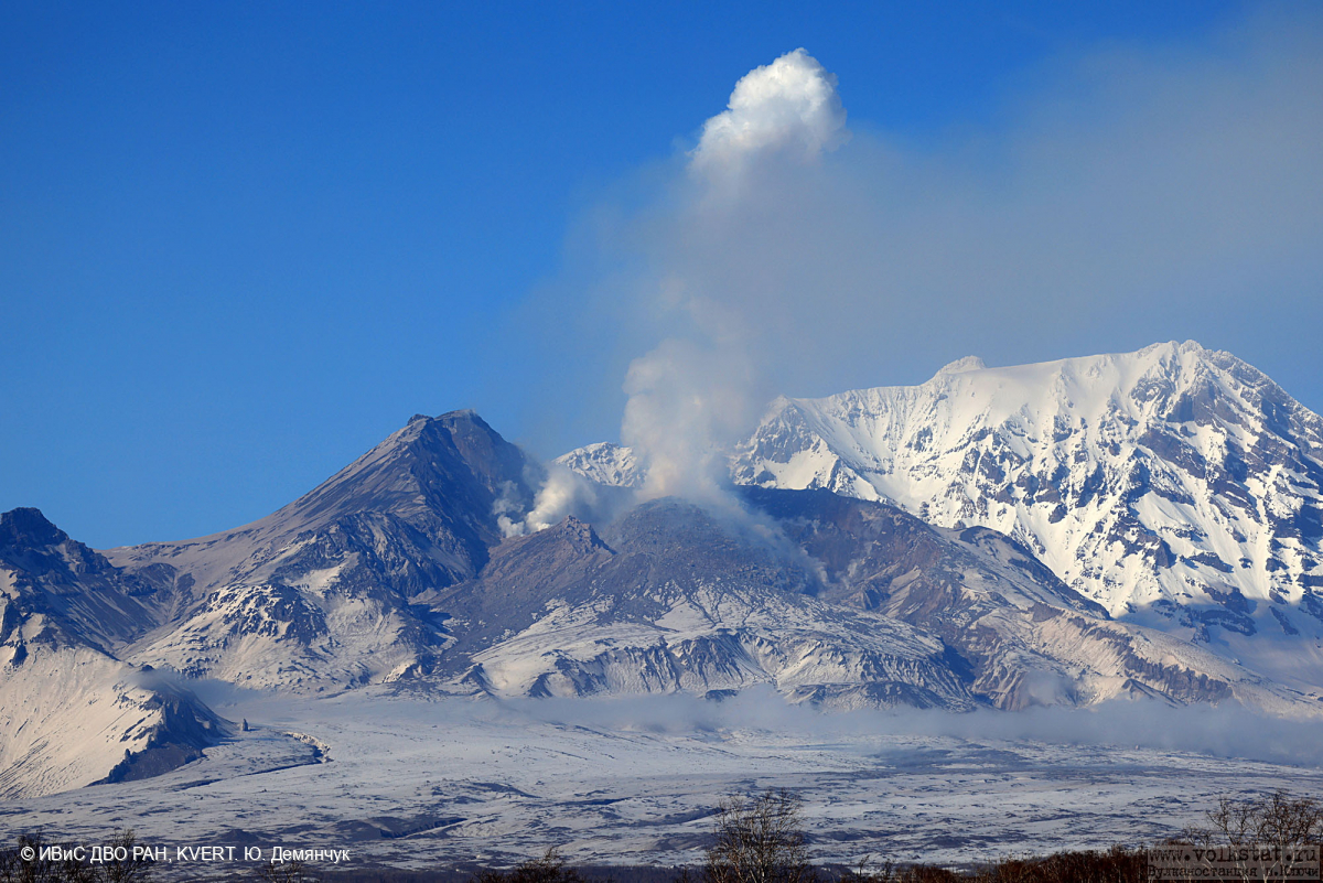
Video and satellite data by KVERT shows a strong wind lifts ash from the southeastern slopes of Sheveluch volcano, and a plume of resuspended ash extends 78 km to the east of the volcano.
An extrusive eruption of the volcano continues. A danger of ash explosions up to 10 km (32,800 ft) a.s.l. is remains. Ongoing activity could affect international and low-flying aircraft.
Volcanic cloud height:
3000-3500 m (9840-11480 ft) AMSL Time and method of ash plume/cloud height determination: 20230527/0110Z – Himawari-9 14m15
Other volcanic cloud information:
Distance of ash plume/cloud of the volcano: 78 km (48 mi)
Direction of drift of ash plume/cloud of the volcano: E / azimuth 96 deg
Time and method of ash plume/cloud determination: 20230527/0110Z – Himawari-9 14m15
Remarks:
resuspended ash plume
Source: Kvert
Photo : Yu. Demyanchuk, IVS FEB RAS, KVERT
Colombia , Purace – Los Coconucos Volcanic Range :
Weekly bulletin of activity of the Puracé volcano – Volcanic chain of Los Coconucos.
From the monitoring of the activity of the PURACÉ VOLCANO – VOLCANIC CHAIN OF LOS COCONUCOS, the MINISTRY OF MINES AND ENERGY through the COLOMBIAN GEOLOGICAL SERVICE (SGC) reports:
During the week between May 16 and May 22, 2023, the seismic activity showed similar values in terms of energy released and number of events, compared to the previous weeks, characterized by the predominance of earthquakes related to fluid dynamics in volcanic vents. This process is accompanied by a deformation process located in the upper part of the volcanic chain of Los Coconucos.
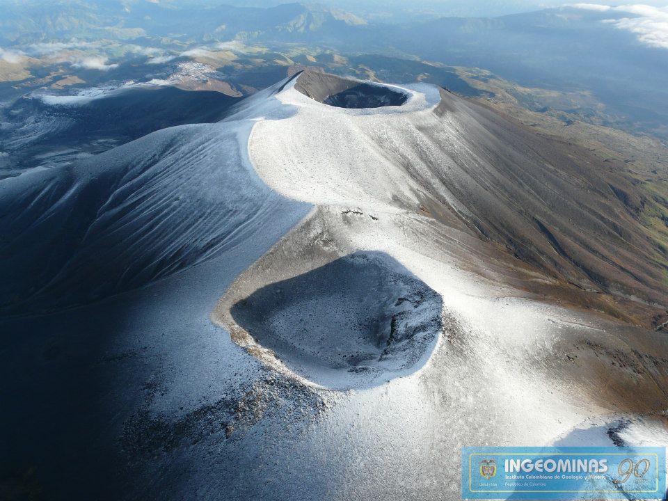
A degassing of the volcanic system was highlighted, with a white column preferentially oriented towards the northwest with stable values in the fluxes of sulfur dioxide (SO2). The concentration of carbon dioxide (CO2) in the crater area of the Puracé volcano remained with high values compared to its baseline. The other parameters measured and used for the diagnosis of volcanic activity did not show significant changes during the period evaluated.
The activity level of the volcano remains at:
YELLOW LEVEL (III): CHANGES IN THE BEHAVIOR OF VOLCANIC ACTIVITY
Source : SGC
Photo : Ingeominas.