May 25 , 2023.
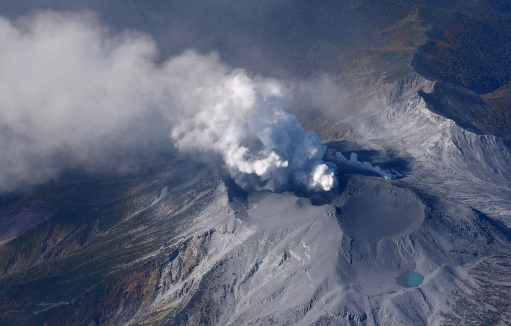
Italy / Sicily , Etna :
Communique on the activity of Etna, May 24, 2023, 17:05 (15:05 UTC).
The National Institute of Geophysics and Volcanology, Osservatorio Etneo, communicates that the monitoring networks recorded at 4:50 p.m. (14:50 UTC), the end of volcanic activity.
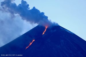
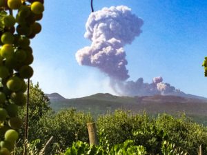
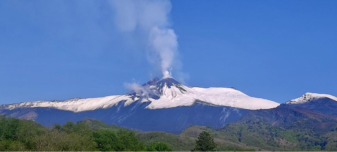
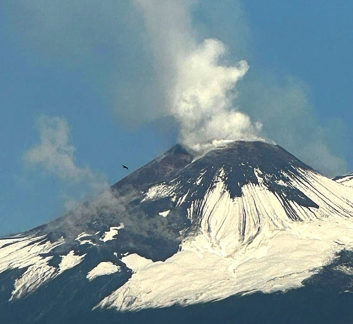
From the analysis of the images of the INGV-OE surveillance cameras, a degassing activity can be observed at the level of the summit craters. In addition, a more in-depth analysis of the images acquired during the night highlighted the presence of eruptions at the Southeast crater and at the Bocca Nuova crater.
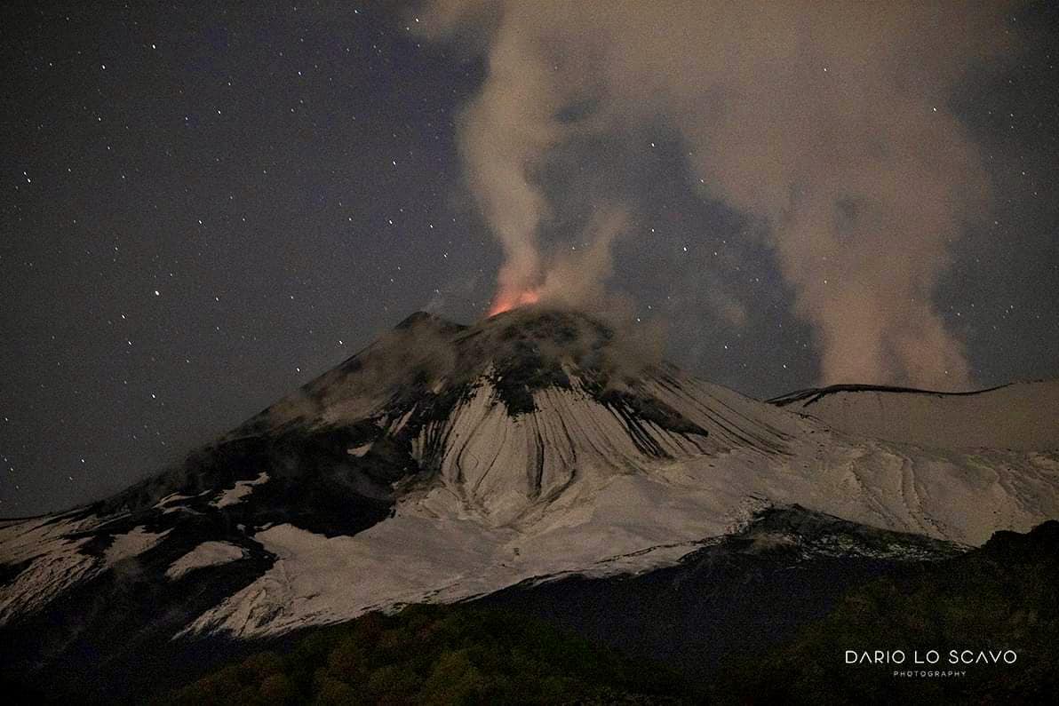
From a seismic point of view, the average amplitude of the volcanic tremor is currently at low levels. The source of the volcanic tremor affects the area of the Southeast crater, at an altitude of approximately 2500 m above sea level. Results of infrasound activity somewhat modest; infrasound events are mainly located at the Bocca Nuova crater.
Data from geodetic networks (GNSS and inclinometer) show no significant change in the last 24 hours.
Further updates will be communicated soon.
Strong explosive eruptions were reported at Etna by INGV starting on 18 May after continuous degassing and moderate seismicity over the previous few days, with significant Strombolian activity and a paroxysmal event at SE Crater on 21 May. Views were often obscured by persistent weather cloud cover. Strombolian activity from SE Crater at 04h56 on 18 May was seen in webcam images from the camera located at Montagnola. The Aviation Color Code was raised to Yellow (second lowest level on a four-color scale) at 12h42 following a sudden increase in volcanic tremor amplitude that began at 12h10. The signal amplitude decreased for a short time but then increased to an even higher level at 13h30.
A seismic swarm in the summit area at 16h44 was immediately followed by ground deformation recorded at the Punta Lucia and Pizzi Deneri summit stations. At 16h56 weak intra-crater Strombolian activity at SE Crater was observed in images taken by the INGV thermal camera at La Montagnola (3 km S). Explosive activity from Bocca Nuova crater starting at 17h00 was visible in thermal images from the Bronte (13 km WNW) webcam, concurrent with infrasonic signals. The Aviation Color Code was raised to Orange at 17h51. The activity likely persisted for a few hours based on satellite images; weather conditions prevented confirmation with webcams. Tremor fluctuated and by 09h27 on 19 May levels had begun to decrease.
Intermittent explosive activity persisted at SE Crater during 19-20 May, with pulsating gas emissions rising from the crater. A sharp increase in volcanic tremors at 07h20 on 21 May was a precursor to significant tall lava fountaining during 07h30-11h40, with ash plumes that rose to 10 km and drifted SW, S, and SE. At 09h37 the Aviation Color Code was raised to Red after INGV field personnel observed ash and lapilli fall on the SW flank and ashfall in Adrano at 560 m elevation.
Lava flows from SE Crater descended the W part of the Valle del Bove as far as 1.9 km E and the S flank as far as 2 km. Satellite data showed a large sulfur dioxide plume drifting E. Weather clouds prevented views of the activity. Tremor levels sharply decreased starting at 11h35 and had stabilized by 12h00. Ashfall was also reported in Catania and Aci Castello. According to news reports the ashfall caused the Catania-Fontanarossa Airport in Sicily to close until 09h00 on 22 May. The runway had been covered in ash and at least 68 flights to and from the airport were cancelled.
The Aviation Color Code was lowered to Orange at 06h01 on 22 May, though lava flows were still active. By 08h32 on 23 May monitoring data indicated that eruptive activity had ceased, and webcam images showed that the lava flows were cooling. The Aviation Color Code was lowered to Yellow at 08h40 and then to Green at 10h51.
Sources: Sezione di Catania – Osservatorio Etneo (INGV), Advanced geospatial Data Management Platform (ADAM), MSN , GVP.
Photos : Dario Lo Scavo , Etna guide , Etnative.
Democratic Republic of Congo , Nyamulagira :
The Observatoire Volcanologique de Goma (OVG) reported that lava continued to erupt from vents in Nyamulagira’s summit crater during 17-23 May. Lava flows began moving into the N and NW parts of the crater beginning on 9 May, towards the low point of the crater rim. Intense incandescence from the summit was visible from Goma (27 km S) during the evenings of 17 and 19 May. Satellite images showed a notable sulfur dioxide plume drifting NW and W during 19-20 May. Drone footage acquired on 20 May captured images of narrow lava flows traveling about 100 m down the W flank.
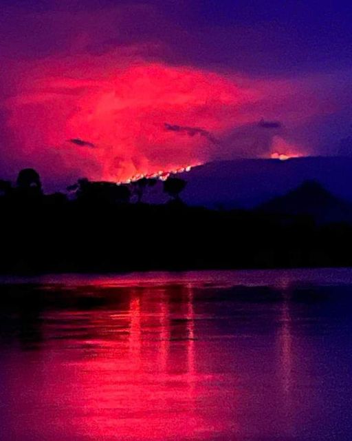
Intense incandescence emanating from the summit was again visible from Goma at around 18h30. Data from the Rumangabo seismic station indicated a downward trend in activity during 17-20 May and a significant decrease during 20-21 May. Though weather clouds were dense over the summit, hot lava on the NW flank was visible in a 22 May Sentinel-2 infrared (SWIR) image.
Sources : Observatoire Volcanologique de Goma (OVG), Sentinel Hub , GVP.
Photo : J Williams via Charles Balagizi.
Mexico , Popocatepetl :
May 24, 11:00 a.m. (May 24, 5:00 p.m. GMT)
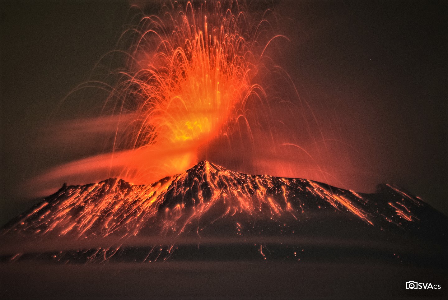
During the last 24 hours, according to the monitoring systems of the Popocatépetl volcano, 10 exhalations accompanied by water vapor, volcanic gases and ash have been detected. 1,066 minutes of high frequency tremors of low to moderate amplitude were recorded, associated with the continuous emission of gas, water vapor and ash, as well as the expulsion of incandescent materials at a short distance from the volcano . Two explosions were recorded, a moderate at 1:43 p.m. and a minor today at 5:03 a.m.). In addition, today at 03:40 a volcano-tectonic earthquake of magnitude 1.2 occurred.
At the time of this report, there is no visibility towards the volcano due to weather conditions in the area. However, it was sometimes possible to observe an emission of water vapor, volcanic gases and small amounts of ash in an East-South-East direction.
In response to the recommendation issued by the scientific advisory committee of the Popocatépetl volcano on May 20, 2023, and to what was reported by the national coordination of civil protection the next day, the volcanic alert traffic light is in the YELLOW PHASE 3.
May 24, 7:00 p.m. (May 25, 01:00 GMT). Actualization
The recording of tremors continues with a moderate to low amplitude. The weather conditions prevailing in the region do not allow visibility towards the volcano, however, it has sometimes been possible to observe an emission of steam and gas with a low ash content. Any changes in activity will be reported in a timely manner.
CENAPRED insistently reiterates the recommendation NOT TO CLIMB to the crater of the volcano, because there is the possibility of explosions, as we have seen on several occasions in the past, involving the emission of incandescent fragments. Therefore, he is required to respect the exclusion radius of 12 km. Also, in heavy rain, stay away from the bottom of ravines due to the danger of mudslides and debris.
Source : Cenapred
Photo : OsvaCs
Japan , Suwanosejima :
JMA reported that the eruption at Suwanosejima’s Ontake Crater continued during 15-22 May. Incandescence was visible nightly, and seismicity remained elevated during 15-19 May. On 16 May an ash plume rose 1.8 km above the crater rim and caused ashfall in Toshima village (3.5 km SSW). On 17 May, an ash plume rose to 1.1 km and drifted NW. Four eruptive events were observed during 21-23 May. On 21 May an eruptive event ejected volcanic blocks up to 200 m from the crater and produced an ash plume that rose 1.8 km above the crater and drifted E. On 22 May an ash plume rose to 1 km above the crater and drifted SE. Two eruptive events on 23 May generated ash plumes that rose 600 m above the crater and drifted SE and S. The Alert Level remained at 3 (on a 5-level scale) and residents were warned to stay 2 km away from the crater.
The 8-km-long island of Suwanosejima in the northern Ryukyu Islands consists of an andesitic stratovolcano with two historically active summit craters. The summit is truncated by a large breached crater extending to the sea on the east flank that was formed by edifice collapse. One of Japan’s most frequently active volcanoes, it was in a state of intermittent Strombolian activity from Otake, the NE summit crater, between 1949 and 1996, after which periods of inactivity lengthened. The largest recorded eruption took place in 1813-14, when thick scoria deposits blanketed residential areas, and the SW crater produced two lava flows that reached the western coast. At the end of the eruption the summit of Otake collapsed, forming a large debris avalanche and creating the open Sakuchi caldera, which extends to the eastern coast. The island remained uninhabited for about 70 years after the 1813-1814 eruption. Lava flows reached the eastern coast of the island in 1884. Only about 50 people live on the island.
Source: Japan Meteorological Agency (JMA),GVP.
Photo : Masanori Genko
Colombia , Chiles / Cerro Negro :
Weekly activity bulletin of the volcanic complex of Chiles and Cerro Negro (CVCCN)
Regarding the monitoring of the activity of the VOLCANOES CHILES AND CERRO NEGRO, the MINISTRY OF MINES AND ENERGY through the COLOMBIAN GEOLOGICAL SERVICE (SGC) informs that:
During the period between May 16 and May 22, 2023, volcanic activity showed an increase in earthquake frequency compared to the previous week, maintaining significant levels, mainly in the daily record. However, it is important to point out that the seismicity was lower than that presented during the months of March or April. The dominance of earthquakes associated with rock fracture within the volcano continues, also maintaining a fluctuating record of the number of fluid dynamics-related events within the volcanic system.
Most fracturing earthquakes continue to be located near and south of the Chiles Volcano, at distances up to 4 km, with depths less than 6 km, from its summit (4700 m level). . The magnitude 3.0 earthquake of May 17 at 10:58 p.m. is highlighted, reported as felt by residents of areas near the CVCCN.
The soil deformation processes recorded by the sensors installed in the volcanoes persist, as well as by the use of remote satellite sensors.
It is important to remember that due to the fluctuating behavior of the CVCCN, the possibility of high-energy earthquakes that can be felt by the inhabitants of the area of influence is not excluded.
The activity level of volcanoes remains at the YELLOW LEVEL ■ (III): CHANGES IN THE BEHAVIOR OF VOLCANIC ACTIVITY
Source : SGC
Photo : Travelgrafía