May 14 , 2023.
Indonesia , Merapi :
Report on the activity of Mount Merapi from March 31, 2023 to April 06, 2023, Published on April 10, 2023
RESULTS OF OBSERVATIONS
Visual
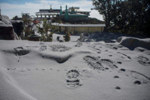
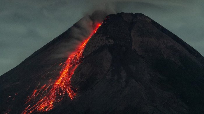
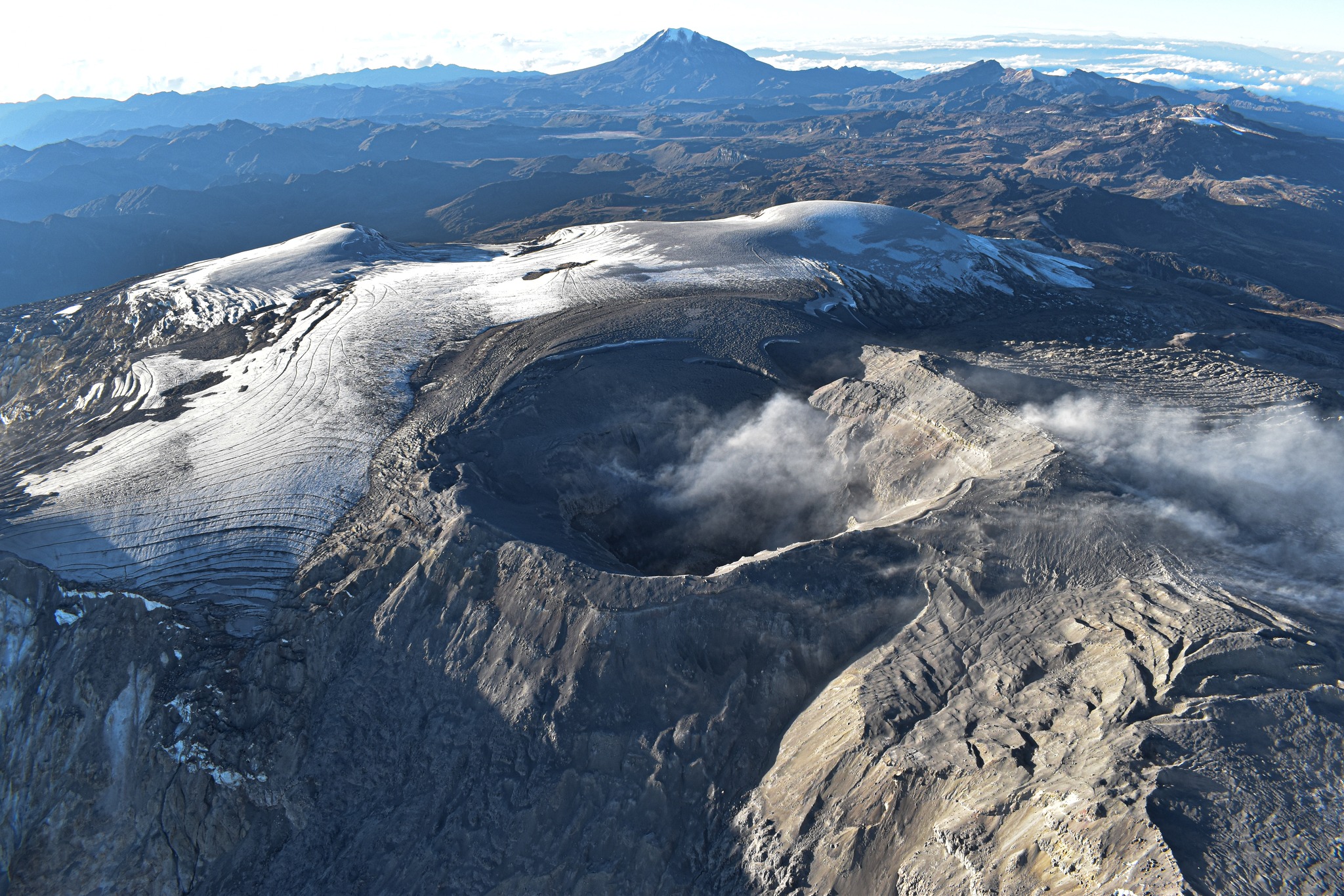
The weather around Mount Merapi is usually sunny in the morning and afternoon, while the evening is foggy. White, fine to thick smoke, low to medium pressure and 200 m high was observed from the Mount Merapi observation post in Ngepos on May 7, 2023 at 08:32.
This week, lava avalanches were observed 106 times to the southwest (upstream of Kali Bebeng) with a maximum slip distance of 1,800 m. The sound of the avalanches was heard 12 times from Babadan post with low to moderate intensity.
On the southwest dome, morphological changes have been observed due to lava avalanches. For the central dome, there is no significant change. According to an aerial photo dated March 13, 2023, the measured volume of the Southwest dome is 1,686,200 m3 and that of the central dome is 2,312,100 m3.
Seismicity
This week, the seismicity of Mount Merapi showed:
4 deep volcanic earthquakes (VTB),
711 avalanche earthquakes (RF),
12 tectonic earthquakes (TT).
16 multi-phase (MP) earthquakes
The intensity of seismicity this week was lower than last week, but the number of RF earthquakes was still quite high.
Deformation
Mount Merapi’s deformation that was monitored using EDM and GPS this week showed a shortening rate of 0.02 cm/day.
Rain and lahars:
This week, it rained at the G. Merapi observation post with a rain intensity of 27 mm/hour for 65 minutes at the Ngepos post on May 06, 2023. No increase in the flow of the rivers descending from Mount Merapi has been reported.
Conclusion
Based on the results of visual and instrumental observations, it is concluded that:
-The volcanic activity of Mount Merapi is still quite high in the form of effusive eruption activity. The state of the activity is defined at the « SIAGA » level.
The current danger potential is in the form of lava avalanches and hot clouds in the South-South-West sector comprising the Boyong River for a maximum of 5 km, the Bedog, Krasak, Bebeng rivers for a maximum of of 7 km. In the South-East sector, it includes the Woro River for a maximum of 3 km and the Gendol River for 5 km. While the ejection of volcanic material in the event of an explosive eruption can reach a radius of 3 km from the summit.
Source : BPPTKG
Photo : ANTARA FOTO/Hendra Nurdiyansyah
Italy / Sicily , Etna :
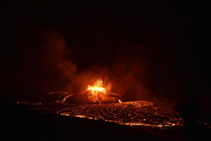
Slight seismic activity on the eastern slope of Etna: for a few days, low-energy seismicity has been affecting the lower eastern slope of Etna, with superficial hypocenters that make them perceptible to the population in the immediate vicinity. In particular, three seismic events were recorded yesterday by the easternmost stations in the Etna region, which are consistent with the warning information received in the operations room. The most energetic event of magnitude 2.1, recorded at 13:40 UTC on 05/12/2023 at a few stations, was located 4 km east of Torre Archirafi at a depth of about 3 km.
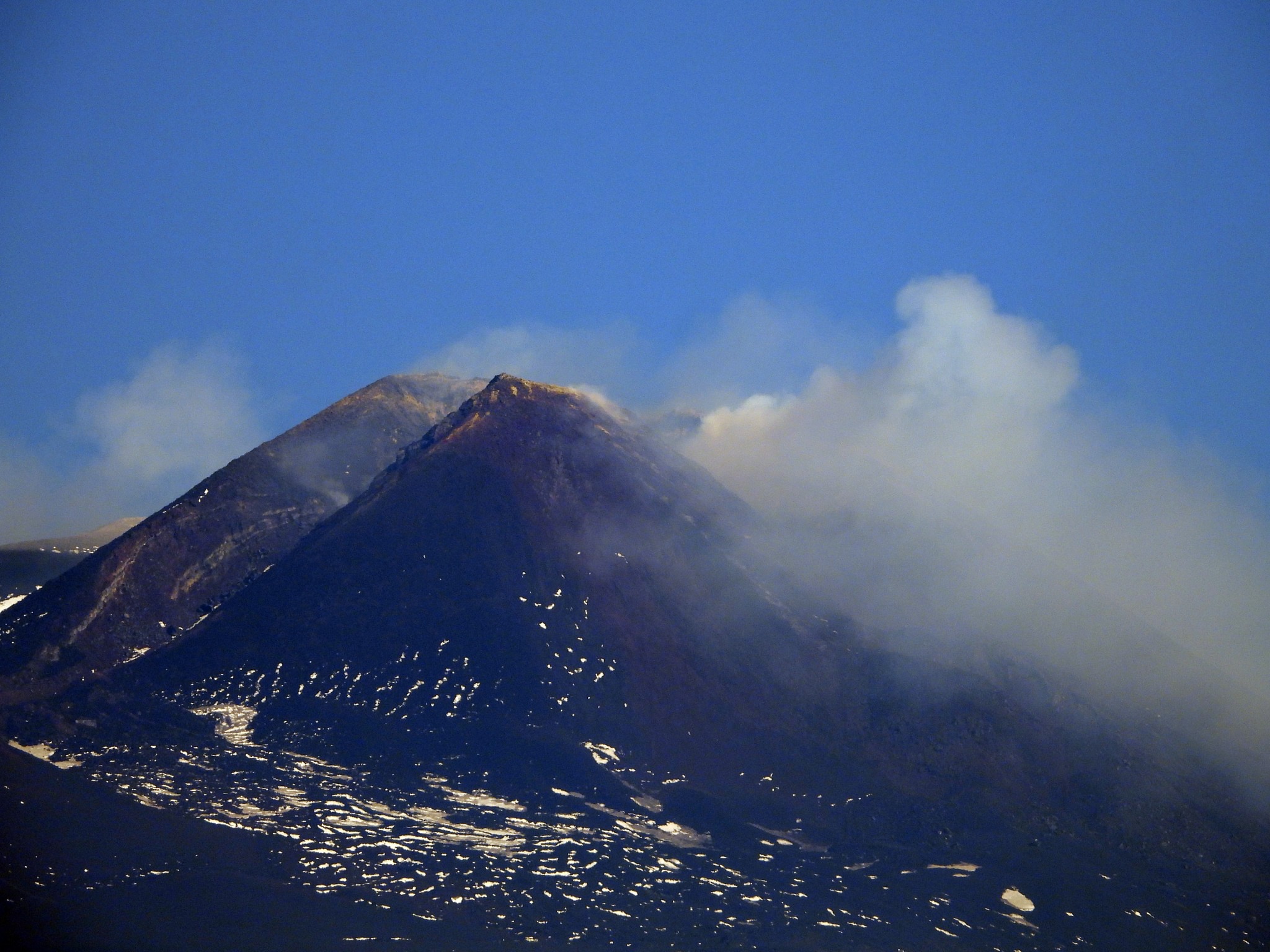
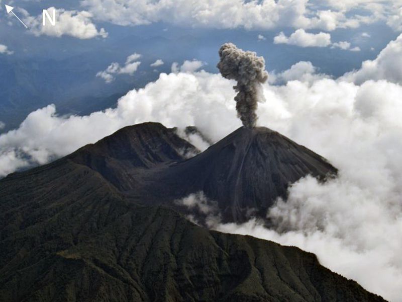
On the morning of May 7, 2023, Etna’s southeast crater looks like this: a dense plume of gas emerges from the « eastern vents » area, evidence that an open conduit now exists there. At the moment there is nothing else, generally the volcano is in a rather calm state, although slowly recharging (a progressive pressurization of the magmatic system is in progress).
What is important to emphasize is that the Southeast Crater is always capable of producing eruptive phenomena, sometimes even highly explosive, at any time, and practically without any premonitory signal. This is not necessarily the start of new, larger eruptive activity, there have been several explosive events in the past, which were not followed by new activity until weeks or months later.
Source : INGV Vulcani, Boris Behncke.
Photo: Boris Behncke
Colombia , Nevado del Ruiz :
Manizales, May 13, 2023 9:35 a.m.
Regarding the monitoring of the activity of the NEVADO DEL RUIZ VOLCANO, the MINISTRY OF MINES AND ENERGY through the COLOMBIAN GEOLOGICAL SERVICE (SGC) informs that:
From 9:00 am yesterday (May 12) until the publication of this bulletin, seismic activity related to the movement of fluids inside volcanic conduits continued to predominate. This seismicity presented similar levels in the number of earthquakes and in the seismic energy released compared to the previous day. Some of these signals have been linked to continuous, pulsating ash emissions, confirmed by web cameras used for volcanic monitoring.
In addition, the seismicity record associated with the fracturing of the rock inside the volcanic edifice continued, which showed similar levels in number of earthquakes and seismic energy compared to the previous day. (May 12). The earthquakes were located to the northeast and southeast of the Arenas crater, at an approximate distance of up to 4 km from it, and at depths between 1 and 4 km.
Regarding surface activity, the maximum height of the column of gas and / or ash observed was 1900 m measured from the summit of the volcano, and the direction of dispersion of the column of gas was towards the East – South -East, with variations to the North-West and North-East of the volcano. For today, the forecast indicates that the wind will be in the direction (East-North-East), so that if the continuous emission of ash continues to be recorded, it is possible that ash fall will occur in the sectors of the municipalities of Tolima that are in this direction of the volcano: Villahermosa, Murillo and Líbano. On the other hand, variations in the degassing of sulfur dioxide and the release of water vapor from the crater into the atmosphere continue, as well as the thermal anomalies at the bottom of the crater observed thanks to satellite monitoring platforms.
The level of activity of the volcano remains at the ORANGE LEVEL of activity or (II): PROBABLE ERUPTION IN TERM OF DAYS OR WEEKS.
Source et photo : SGC
Ecuador , Reventador :
DAILY REPORT OF THE STATE OF THE REVENTADOR VOLCANO, Friday May 12, 2023.
Information Geophysical Institute – EPN.
Surface Activity Level: High, Surface Trend: Unchanged
Internal activity level: Moderate, Internal trend: No change
Seismicity: From May 11, 2023, 11:00 a.m. to May 12, 2023, 11:00 a.m.:
The following table shows the number of seismic events from the REVN reference station over the past 24 hours.
Explosion(EXP):55
Long Period (LP):65
Transmit Tremor (TREM):9
Harmonic Tremor (TRARM):2
Rains / Lahars:
There are no reports of rain.
Emission / Ash Column:
Most of the time the weather remained cloudy. Washington’s VAAC also reported no ash emissions in the past 24 hours.
Gas:
The MOUNTS system recorded 10.2 tonnes of sulfur dioxide (SO2), measured on 05/11/2023 at 1:59 p.m. TL
Other Monitoring Parameters:
MIROVA-MODIS recorded 1 low thermal alert in the last 24 hours.
Observation:
During the night, an incandescence was observed at the level of the crater. Due to cloudiness, there are no observations of surface activity today.
Alert level: Orange.
Source : IGEPN.
Photo : f-Naranjo , GVP.
Mexico , Popocatepetl :
May 13, 11:00 a.m. (May 13, 5:00 p.m. GMT)
During the last 24 hours, according to the monitoring systems of the Popocatépetl volcano, 192 exhalations accompanied by water vapor, volcanic gases and ash have been detected.
During this period, 4 minor explosions were recorded at 1:18 p.m. and 2:52 p.m. local time yesterday, and at 12:12 a.m. and 8:05 a.m. local time today, in addition 597 minutes of tremors were recorded, of which 15 were considered harmonic tremors .
Explosions that occur on Popocatépetl or any active volcano are accompanied by seismic and sound signals, the latter recorded by means of pressure detectors or microphones. It is possible to hear them with different levels of intensity, depending on the atmospheric factors at the time of the events or the morphological conditions of the crater. This is a normal phenomenon and is not necessarily an indication of increased volcanic activity. It should be noted that in the current state of Popocatépetl, characterized by the formation of small lava domes, and their subsequent destruction by explosions, mainly of small to moderate size, it is likely that in the coming days or weeks the population near the volcano will perceive these audible phases.
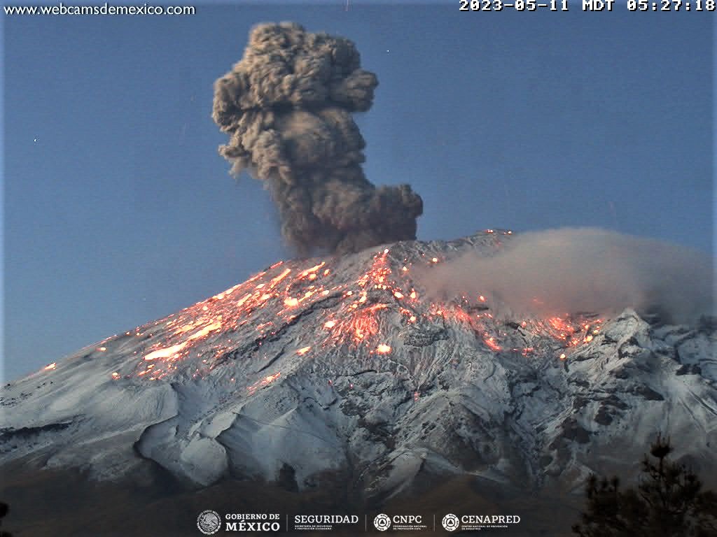
During the morning, and at the time of this report, the continuous emission of volcanic gases and ash is observed in a South-East (SE) direction.
The National Center for Communication and Civil Protection Operations (CENACOM) today reported a slight fall of ash in the municipalities of Nealtican, Huejotzingo and Domingo Arenas, in the state of Puebla.
CENAPRED insistently reiterates the recommendation NOT TO CLIMB to the crater of the volcano, because there is the possibility of explosions, as we have seen on several occasions in the past, involving the emission of incandescent fragments. Therefore, he is required to respect the exclusion radius of 12 km. Also, in heavy rain, stay away from the bottom of ravines due to the danger of mudslides and debris.
The Popocatépetl volcanic alert traffic light is in YELLOW PHASE 2.
Source et photo : Cenapred.