August 12 , 2021 .
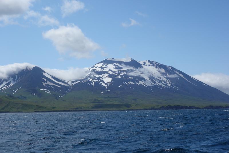
Alaska , Atka Volcanic Complex :
AVO/USGS Volcanic Activity Notice
Current Volcano Alert Level: ADVISORY
Current Aviation Color Code: YELLOW
Issued: Wednesday, August 11, 2021, 2:22 PM AKDT
Source: Alaska Volcano Observatory
Notice Number: 2021/A629
Location: N 52 deg 19 min W 174 deg 8 min
Elevation: 5030 ft (1533 m)
Area: Aleutians
Volcanic Activity Summary:
The Alaska Volcano Observatory is raising the Aviation Color Code and Alert Level at the Atka volcanic complex to YELLOW/ADVISORY after detecting an increased number of small, shallow earthquakes over the past day. These earthquakes have been located 3 to 6 km (1.9 to 3.7 miles) deep and around 7 km (4.3 miles) southwest of Korovin Volcano. The earthquakes represent an increase from background seismic activity, but may not necessarily lead to an eruption.
Previous alerts by the Alaska Volcano Observatory for unrest for the Atka volcanic complex have been for Korovin Volcano, the site of the most recent historical eruptions. The location of earthquakes, however, is not specific to Korovin and could be related to several other volcanic vents that are part of the Atka volcanic complex, including Mount Kliuchef.
The Alaska Volcano Observatory will continue to monitor the Atka volcanic complex for signs of volcanic activity. The area is monitored by local seismic and infrasound sensors, satellite data, and regional lightning detection instruments.
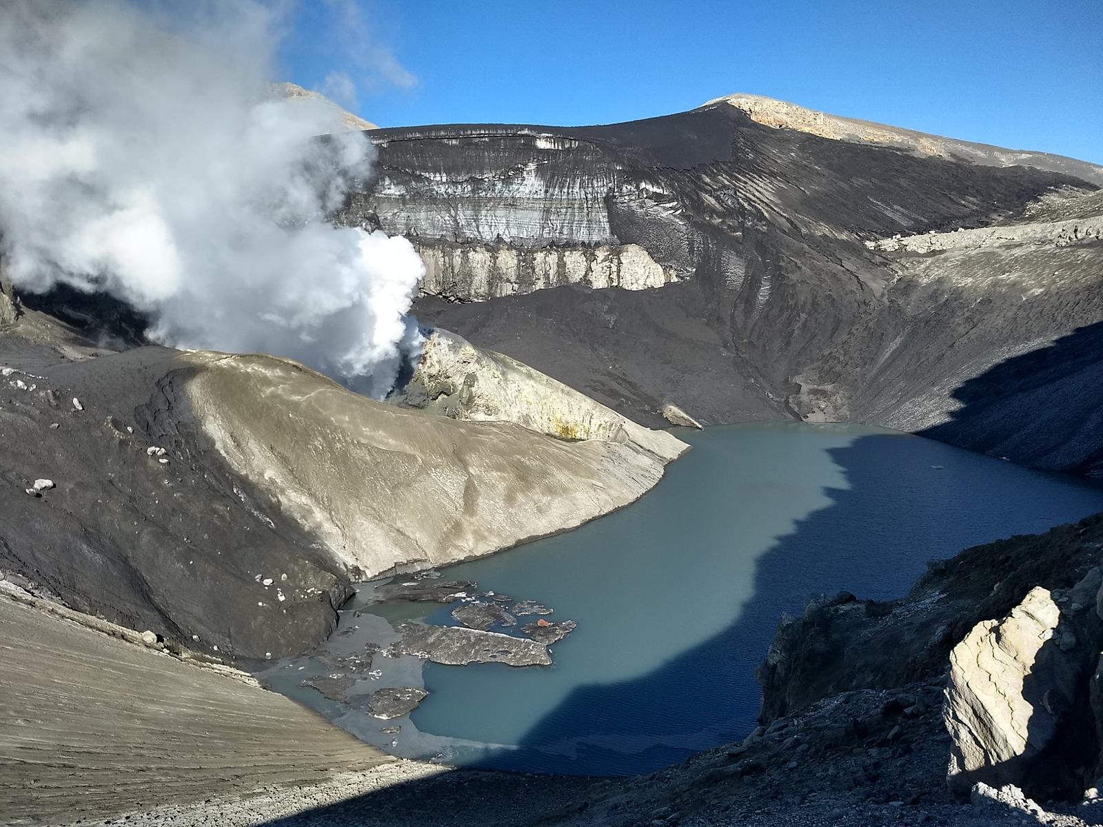
The largest volcanic center in the central Aleutians, Atka consists of a central shield and Pleistocene caldera with several post-caldera volcanoes. A major dacitic explosive eruption accompanied formation of the caldera about 500,000 to 300,000 years ago. The most prominent of the post-caldera stratovolcanoes are Kliuchef and Sarichef, both of which may have been active in historical time. Sarichef has a symmetrical profile, but the less eroded Kliuchef is the source of most if not all historical eruptions. Kliuchef may have been active on occasion simultaneously with Korovin volcano to the north. Hot springs and fumaroles are located on the flanks of Mount Kliuchef and in a glacial valley SW of Kliuchef.
Sources : AVO. GVP.
Photo : Schaefer, Janet / Alaska Volcano Observatory / Alaska Division of Geological & Geophysical Surveys
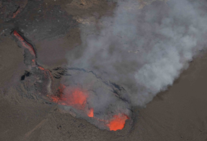
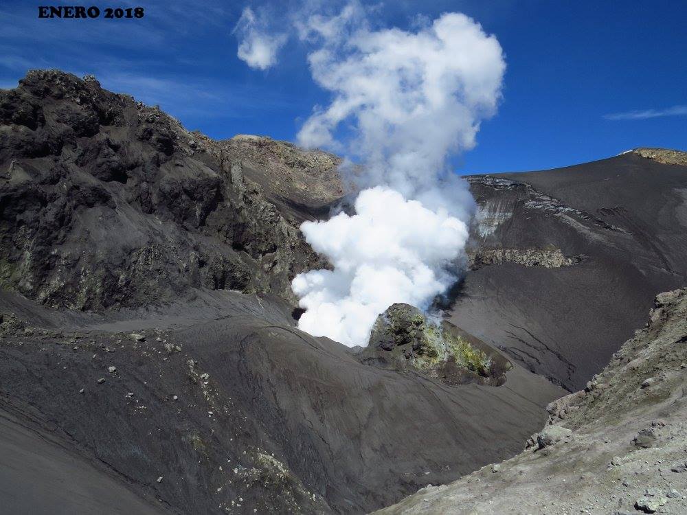
Chile , Copahue :
The Argentine Geological Mining Service (SEGEMAR) through its Argentine Volcanic Monitoring Observatory (OAVV) reports that since Monday, August 9, 2021, surveillance cameras installed near the Copahue volcano have started to record an increase in surface activity, characterized by an increase in gas emissions, an intense nocturnal incandescence, and an increase in the energy of the continuous volcanic tremor signal.
OBSERVATIONS:
According to the analysis carried out on high-resolution satellite images from Planet Scope in recent weeks, it has been possible to observe a gradual decrease in the remains of the lake from the volcano’s crater. This information was correlated by a decrease in the SO2 emission values obtained by the DOAS equipment, lower than the values normally recorded during periods of absence from the crater lagoon.
In addition, at the beginning of last weekend, an increase in the energy and frequency of the continuous tremor signal began to be recorded, which may indicate a clogging of the emission ducts and a consequent overpressure caused by the hot gases accumulated.
Finally, during the first hours of Monday, August 9, an increase in the surface activity of the volcano began to be recorded, accompanied by the release of gas and water vapor, causing depressurization of the system. This is evidenced by an increase in SO2 emissions, reaching maximum values of 7,200 tonnes, according to information provided by images from the Tropomi satellites, and an intense night-time incandescence, produced by the combustion of gases.
This recorded increase in the tremor signal, accompanied by incandescence, and an increase in gas emission, is a phenomenon that has been recorded in previous years and on similar dates, and is mainly associated with the disappearance of the crater lagoon and over-pressurization. of the surface system.
It should be noted that based on information from the monitoring network installed near the volcano, there was no increase in the volcano-tectonic (VT) seismic activity of the volcano, nor any other increase in any other monitoring parameter. could indicate a new rise of magmatic material to the surface.
With the current scenario, it is possible to expect, as in previous years, that minor volcanic ash pulses could be recorded, like the one recorded on July 2, or small explosions inside the volcanic crater. This is why it is advisable to respect the exclusion radius around the crater of the volcano, and to check with the civil protection authorities.
Any type of major eruptive activity is excluded, the volcano being within the parameters expected for the current activity level of the Copahue volcano.
Source : Cegemar .
Photos : Carpediem1971 , Sernageomin .
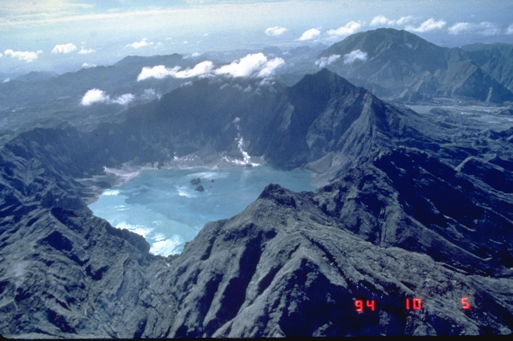
Philippines , Pinatubo :
PINATUBO VOLCANO BULLETIN , 12 August 2021 , 08:00 A.M.
This serves as a notice for the lowering of the alert status of Pinatubo Volcano from Alert Level 1 (Low-level Unrest) to Alert Level 0 (Normal).
Since 1 July 2021, there has been a continued decline in earthquake activity and a return to baseline seismic parameters in Pinatubo Volcano. A total of 104 volcanic earthquakes or an average of 2-3 events/day having magnitudes of ML0.8 to ML1.3 was recorded by the Pinatubo Volcano Network from 1 July to 11 August 2021. This is a significant decrease compared to the period from 28 January to 30 June 2021 when earthquake activity averaged 12-13 events/day and ranged in strength from ML 0.7 to ML3.2. In addition, diffuse CO2 flux from the Pinatubo Crater lake, which is an indication of deep magma degassing, was measured at 263 tonnes/day in mid-April 2021, well within the background range of <1000 tonnes/day recorded since 2008. Lastly, data from continuous GPS monitoring of the Pinatubo edifice that began in March 2021 indicate that ground deformation detected by InSAR data analysis for the period June 2020 to May 2021 is likely tectonic, rather than volcanic, in origin.
In view of the above, PHIVOLCS-DOST is now lowering the alert status of Pinatubo Volcano from Alert Level 1 to Alert Level 0. This means observational parameters have returned to baseline levels and the volcano has returned to a period of quiescence. However, in the event of a renewed increase in any one or combination of the above monitoring parameters, the alert status may step up once again to Alert Level 1. Entry into the Pinatubo Crater area must always be conducted with caution due to the perennial hazards of rockfalls, landslides and lethal expulsions of volcanic CO2. Furthermore, people living in valleys and active river channels are cautioned to remain vigilant against sediment-laden streamflows and lahars in the event of prolonged and heavy rainfall.
DOST-PHIVOLCS is closely monitoring the volcano’s condition and any new development will be relayed to all concerned.
Source : Phivolcs .
Photo : GVP , Ray Punungbayan, 1994 (Philippine Institute of Volcanology and Seismology).
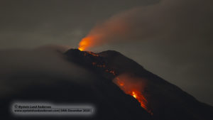
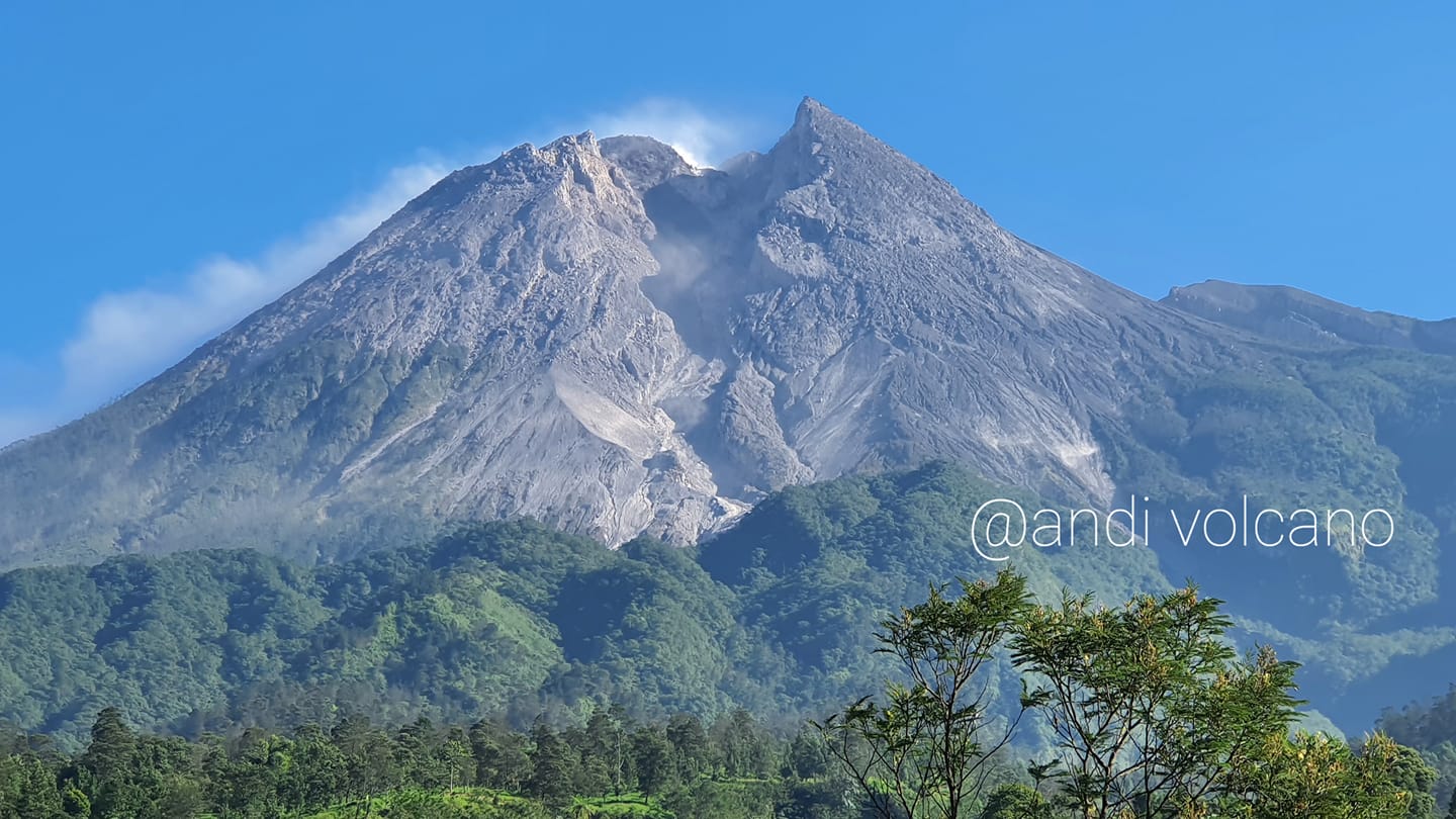
Indonesia , Merapi :
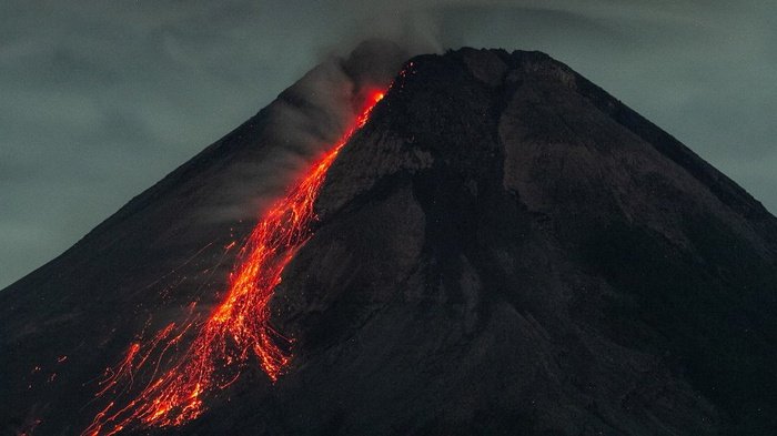
BPPTKG reported that the lava dome just below Merapi’s SW rim and the lava dome in the summit crater both remained active during 30 July-5 August. The SW rim dome volume was an estimated 1.895 million cubic meters and about 3 m tall. A total of seven pyroclastic flows descended the SW flank as far as 2 km and as many as 84 lava avalanches traveled a maximum of 2 km SW. Multiple pyroclastic flows traveled 2-3 km down the SW flank on 8 August and ash plumes rose 1 km above the summit. According to a news article ashfall was reported in several local communities. Pyroclastic flows traveled up to 3 km down the SW flanks multiple times during 9-10 August. BNPB noted that a small fire on the SW flank, 2.5 km from the crater, was set by ejected incandescent material; the fire burned an area of only 30 square meters during 25-26 August. The Alert Level remained at 3 (on a scale of 1-4), and the public was warned to stay 5 km away from the summit.
1. The hot cloud of the Merapi avalanche on August 12, 2021 at 01.07 WIB was recorded on a seismogram with an amplitude of 67 mm and a duration of 157 seconds. The glide distance is 2500 m to the southwest.
2. The hot cloud of the Merapi avalanche on August 12, 2021 at 01.16 WIB was recorded on a seismogram with an amplitude of 43 mm and a duration of 111 seconds. The glide distance is 1800 m to the southwest.
3. The hot cloud of the Merapi avalanche on August 12, 2021 at 01:53 WIB was recorded on a seismogram with an amplitude of 57 mm and a duration of 232 seconds. The glide distance is 3000 m to the southwest.
4. The hot cloud of the Merapi avalanche on August 12, 2021 at 02:46 WIB was recorded on a seismogram with an amplitude of 19 mm and a duration of 110 seconds. The glide distance is 1800 m to the southwest.
Validation of the sliding distance of the hot clouds of Mount Merapi on August 10, 2021:
On Sunday (8/8) at 4:58 am WIB, there was a series of hot clouds over Mount Merapi which slid southwest (Kali Bebeng) with a slide distance of 3000m. An eruption column was observed up to 1000 m above the peak.
This hot cloud was recorded on a seismogram with an amplitude of 20 mm and a duration of 222 seconds. At the time of the incident, the wind was blowing west and caused ash rain in several places, including Babadan Post, Krinjing, Patent, Sengi, Tlogolele, Ketep and Magelang City.
On August 9, 2021, the BPPTKG and a team from the UGM flew a drone in the Kali Bebeng channel to validate the glide distance of the hot avalanche clouds. Based on the mapping results, the furthest slide distance is 3 km from the summit of Mount Merapi.
The sliding distance of this hot cloud is still within the recommended potential danger zone, which is 3 km from the peak for Kali Woro channel, and 5 km from the peak for Kali Gendol, Kuning, Boyong, Bedog, Krasak , Bebeng.
The level of volcanic activity of Mount Merapi is currently still high. Explosive eruptions are still likely to occur with the threat of a danger in the form of ejection of volcanic material within a radius of 3 km around the peak of Merapi.
The public is advised not to carry out activities in designated areas of potential risk. Stay alert and always watch for information about BPPTKG’s Mount Merapi activity.
Source : GVP , BPPTKG.
Photos : Andi Volcano , ANTARA FOTO/Hendra Nurdiyansyah
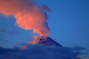
Guatemala , Pacaya :
Type of activity: Strombolian.
Morphology: Composite Stratovolcano
Geographical location: 14 ° 22’50˝ Latitude N; 90 ° 36’00˝ Longitude W.
Altitude: 2,552 meters above sea level.
Atmospheric conditions: clear
Wind: North-East
Precipitation: 0.00 mm.
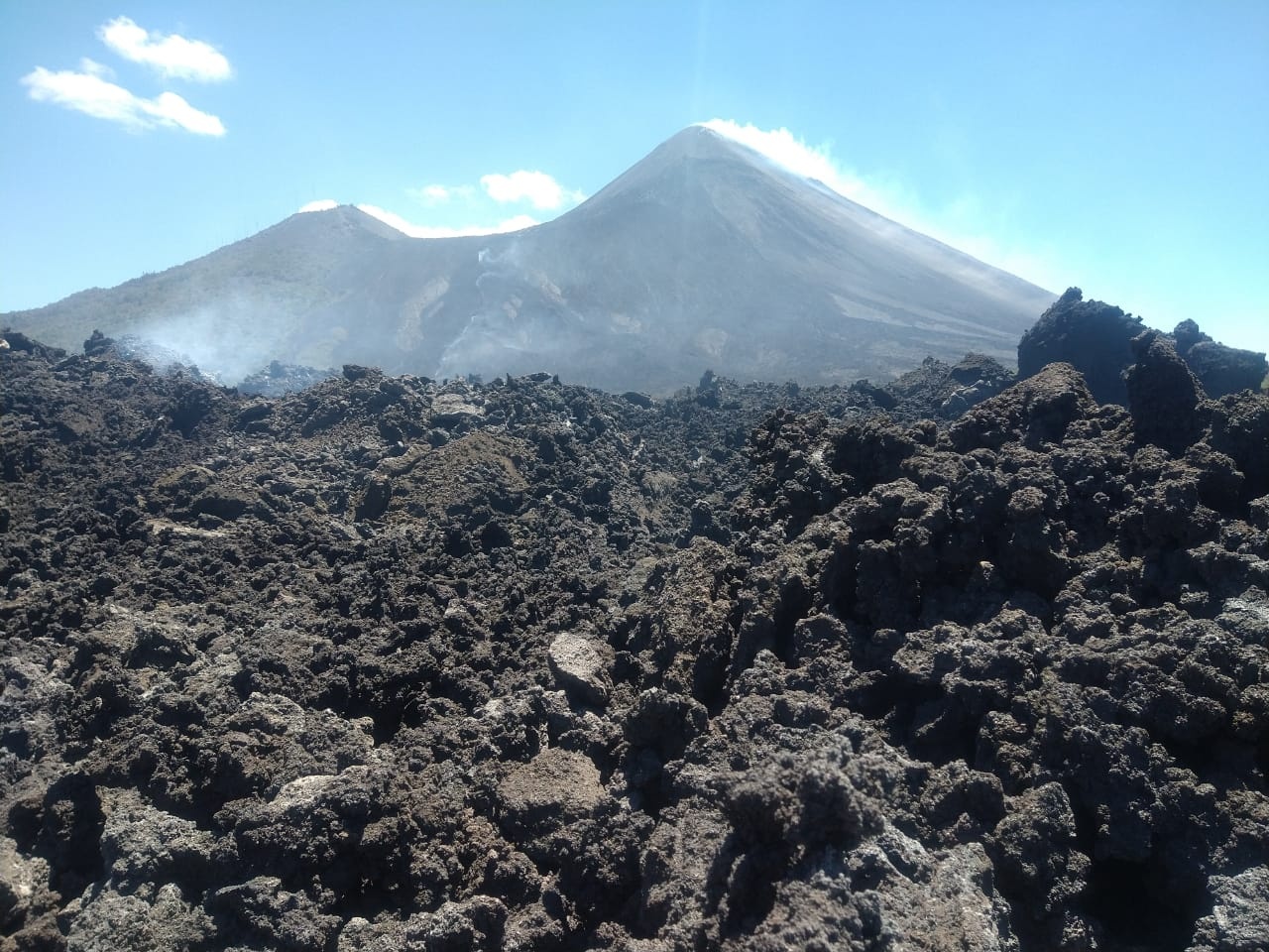
ACTIVITY:
In the Mackenney crater, a weak degassing is generated and at moderate times, of white and blue color which moves towards the southwest. No generation of ash is observed, nor expulsion of incandescent material. INSIVUMEH’s seismic stations record short, low-frequency events due to the movement of magma and gases inside the volcanic edifice, as well as to interruptions in the abundant degassing in the crater. It is not excluded that lava flows or degassing columns with abundant ash are generated.
Source : Insivumeh
Photo : noticias san vincente pacaya.