February 02 , 2021.
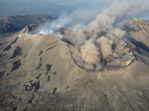
La Réunion , Piton de la Fournaise :
Seismicity
In January 2021, the OVPF recorded in the Piton de la Fournaise massif in total:
• 7 superficial volcano-tectonic earthquakes (0 to 2.5 km above sea level) below the summit craters;
• 0 deep earthquake (below sea level);
• 182 collapses (in the Dolomieu Crater, the Enclos Fouqué and Piton de Crac , and the East River).
The seismicity under the Piton de la Fournaise during the month of January 2021 remained low, with only 7 superficial volcano-tectonic earthquakes recorded under the summit area
Deformation
The inflation (swelling) of the building that had resumed following the eruption of December 7-8, 2020 stopped at the end of December 2020. Thus, during the month of January 2021, the GPS in the summit area and in the far field did not record any particular signals, with the exception of the GPNG and GPSG stations located in the Grandes Pentes area and which continued to record a
subsidence and an eastward movement. The GPSG station (south of the Grandes Pentes) sank approximately 22 cm and moved eastward by approximately 17 cm between October 2019 and January 2021; and the GPNG station (north of the Grandes Pentes) sank about 12 cm and moved eastwards by about 6 cm between October 2020 and January 2021.

Gas geochemistry
CO2 concentration in the soil
In the far field (Plaine des Cafres and Plaine des Palmistes sectors): the period following the eruption of October 25-27, 2019 was marked by a further increase in the flow of CO2 in the soil, with a first peak just before the eruption of February 10-16, 2020. Before the eruption of April 2-6, 2020, the flow of CO2 in the soil increased significantly, and reached the highest values since the network was operational for two weeks following the eruption.
After April 21, the network recorded a continuous decrease in CO2 emissions in the soil on the flanks of the volcano both in the far field (Plaine des Cafres and Plaine des Palmistes sectors) and in the near field (Gîte du volcano). A new increase in the flow of CO2 has been recorded since mid-August on the entire network and a peak was reached on September 13, two weeks before the intrusion of September 28-30, 2020. Following the intrusion of September 2020, a downward trend in CO2 emissions in soil was recorded before a further increase in December 2020. The high values recorded in September and December 2020 are well below the peak recorded in April 2020 … / …
Source : OVPF.
Lire L’article : http://www.ipgp.fr/sites/default/files/ovpf_20210201_bullmensu.pdf
Photo : Imaz Press
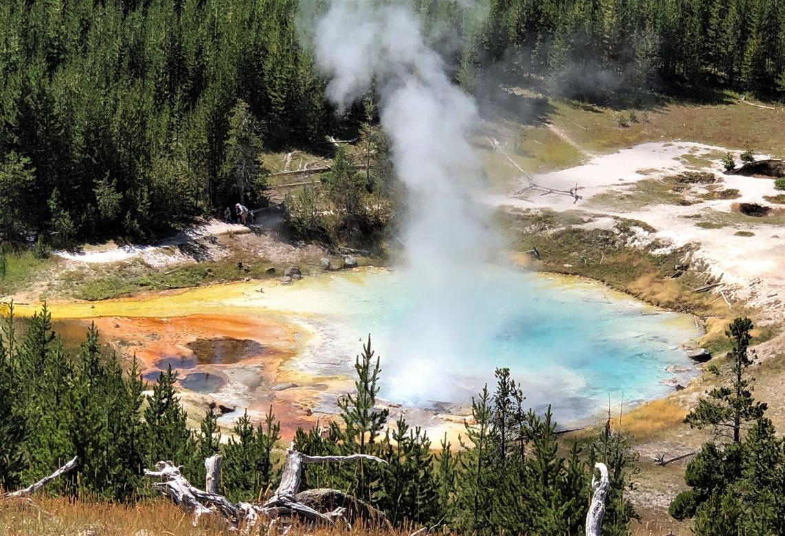
United-States , Yellowstone :
44°25’48 » N 110°40’12 » W,
Summit Elevation 9203 ft (2805 m)
Current Volcano Alert Level: NORMAL
Current Aviation Color Code: GREEN
Recent work and news
It was a quiet start to 2021 in Yellowstone. Steamboat Geyser erupted only twice, on January 2 and 12. A longer time between eruptions at Steamboat is not unusual in the winter months. During the winters of both 2018-2019 and 2019-2020, the interval between eruptions at Steamboat was longer compared to summer months. This seasonal effect is probably related to lower groundwater levels in winter versus summer. Hopefully Steamboat will continue to put on a show for visitors in 2021, but there’s no guarantee. Just like the current episode of frequent eruptions started with no warning, eruptions could also stop suddenly.
Seismicity
During January 2021, the University of Utah Seismograph Stations, responsible for the operation and analysis of the Yellowstone Seismic Network, located 98 earthquakes in the Yellowstone National Park region. The largest event was a minor earthquake of magnitude 3.2 located 2 miles east-northeast of Norris Junction in Yellowstone National Park on January 6 at 8:38 AM MST and was part of a small swarm of 10 earthquakes in the area, all on January 6 and with magnitudes from -0.1 to 3.2.
An additional swarm of 20 earthquakes, with magnitudes between -0.1 and 2.1, was recorded 7 miles east-southeast of Madison Junction in Yellowstone National Park during January 23–24.
Yellowstone earthquake activity remains at background levels.
Ground deformation
Deformation rates and styles at Yellowstone, as recorded by continuous GPS stations, have been steady over the past year. Subsidence of Yellowstone Caldera, which has been ongoing since 2015, continued at an average rate of 2-3 cm (about 1 in) per year. In the area of Norris Geyser Basin, no significant uplift or subsidence has been detected by a nearby GPS station since the start of 2020.
Source : YVO.
Photo : Pat Shanks. Imperial Geyser.
Indonesia , Semeru :
VOLCANO OBSERVATORY NOTICE FOR AVIATION – VONA.
Issued : February 01 , 2021
Volcano : Semeru (263300)
Current Aviation Colour Code : ORANGE
Previous Aviation Colour Code : orange
Source : Semeru Volcano Observatory
Notice Number : 2021SMR04
Volcano Location : S 08 deg 06 min 29 sec E 112 deg 55 min 12 sec
Area : East java, Indonesia
Summit Elevation : 11763 FT (3676 M)
Volcanic Activity Summary :
Eruption with volcanic ash cloud at 23h36 UTC (06h36 local)
Volcanic Cloud Height :
Ash-cloud is not visible
Other Volcanic Cloud Information :
Ash-cloud moving to northeast
Remarks :
cloud height beyond the summit
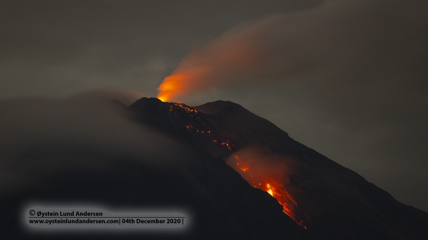
Level of activity at level II (WASPADA). G. Semeru (3,676 m above sea level) is continuously erupting. There are explosive and effusive eruptions, causing lava flows towards the south and south-eastern slopes, as well as explosions of incandescent rocks around the summit crater.
The volcano is partially covered with fog over the entire volcano cone. Eruptions still occur but the eruption column and smoke from the crater were not observed. The weather is sunny to rainy, the winds weak to the North-East, South and South-West.
According to the seismographs of February 1, 2021, it was recorded:
47 s eruption / explosion earthquake
4 avalanche earthquakes
29 emissions earthquakes
2 deep volcanic earthquakes
3 distant tectonic earthquakes
1 Flood signal.
Source : Magma Indonésie , PVMBG.
Photo : Oystein lund Andersen .
Peru , Sabancaya :
Analysis period: from January 25, 2021 to January 31, 2021, Arequipa, February 01, 2021.
Alert level: ORANGE
The Geophysical Institute of Peru (IGP) reports that the eruptive activity of the Sabancaya volcano remains at moderate levels, that is, with the recording of an average of 44 daily explosions, with columns of ash and gas up to 3.5 km altitude above the summit of the volcano and their subsequent dispersion. Therefore, for the following days, no significant change is expected in the eruptive activity.
The IGP recorded and analyzed the occurrence of 1049 earthquakes of volcanic origin, associated with the circulation of magmatic fluids inside the Sabancaya volcano. An average of 44 explosions were recorded daily of low to medium intensity. During this period, Volcano-Tectonic (VT) earthquakes associated with rock fractures were located mainly in the North-East and North of Sabancaya and presented magnitudes between M1.4 and M2, 6.
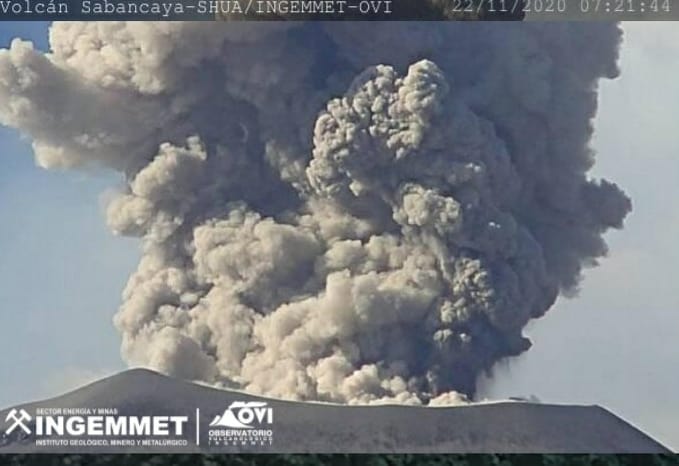
The monitoring of the deformation of the volcanic structure using GNSS techniques (processed with fast orbits) does not present any significant anomalies. However, in general, an inflation process has been observed in the south-eastern sector of Sabancaya and the northern sector (around the Hualca Hualca volcano). Visual surveillance made it possible to identify columns of gas and ash up to 3.5 km altitude above the summit of the volcano, which were scattered towards the South, South-West, East and North-East sectors of the volcano. Sabancaya. Satellite monitoring identified the presence of 3 thermal alerts, with values between 3 and 15 MW, associated with the presence of a lava dome on the surface of the volcano’s crater.
RECOMMENDATIONS
• Keep the volcanic alert level in orange.
• Do not approach within a radius of less than 12 km from the crater.
Source : IGP.
Photo : Observatorio Vulcanológico INGEMMET @ingemmet.peru
Kamchatka , Ebeko :
VOLCANO OBSERVATORY NOTICE FOR AVIATION (VONA).
Issued: February 01 , 2021
Volcano: Ebeko (CAVW #290380)
Current aviation colour code: ORANGE
Previous aviation colour code: orange
Source: KVERT
Notice Number: 2021-18
Volcano Location: N 50 deg 41 min E 156 deg 0 min
Area: Northern Kuriles, Russia
Summit Elevation: 1156 m (3791.68 ft)
Volcanic Activity Summary:
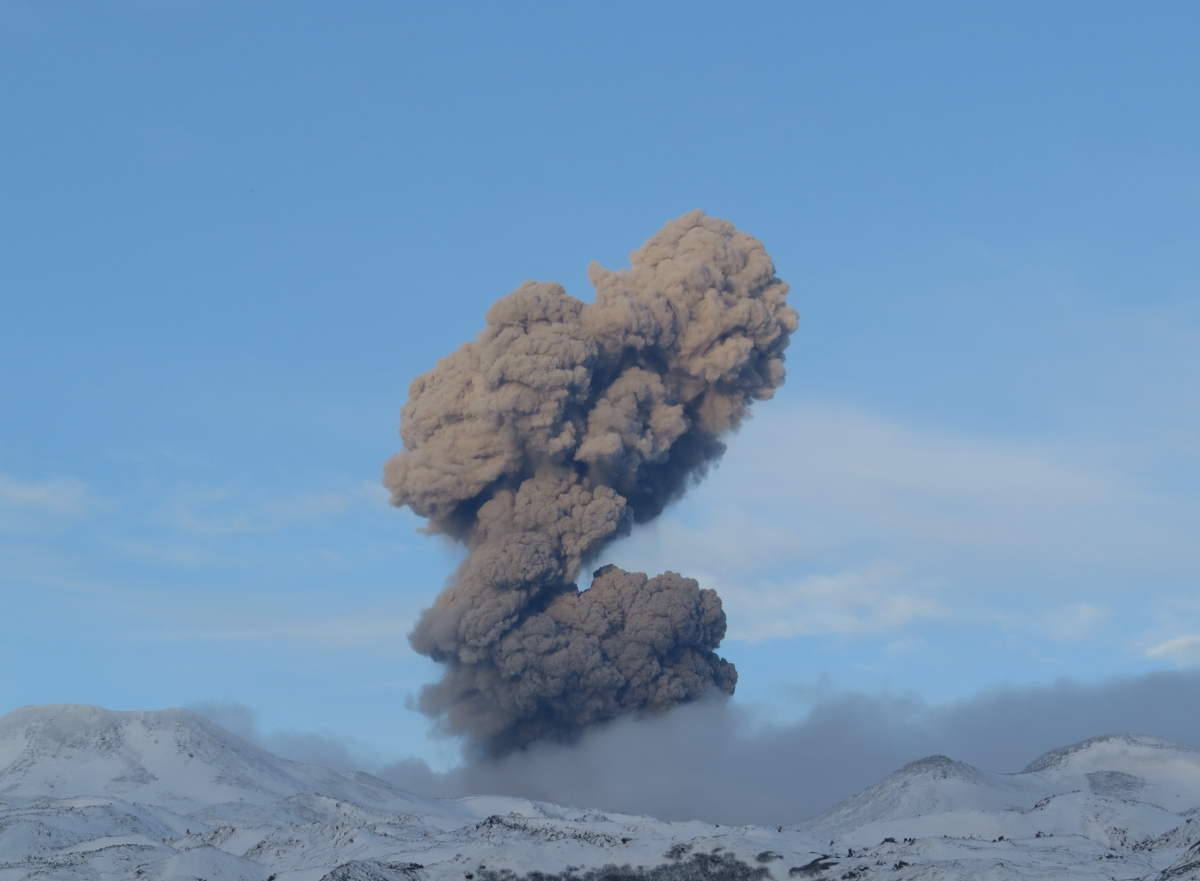
A moderate eruptive activity of the volcano continues. According to visual data by volcanologists from Severo-Kurilsk, explosion sent ash up to 2.3 km a.s.l., an ash cloud is drifting to the east of the volcano.
This activity continues. Ash explosions up to 6 km (19,700 ft) a.s.l. could occur at any time. Ongoing activity could affect low-flying aircraft and airport of Severo-Kurilsk.
Volcanic cloud height:
2100-2300 m (6888-7544 ft) AMSL Time and method of ash plume/cloud height determination: 20210201/2257Z – Visual data
Other volcanic cloud information:
Distance of ash plume/cloud of the volcano: 3 km (2 mi)
Direction of drift of ash plume/cloud of the volcano: E
Time and method of ash plume/cloud determination: 20210201/2257Z – Visual data
Source : Kvert.
Photo : S. Lakomov