November 29 , 2020.
Indonesia , Ili Lewotolok :
Level of activity at level II (WASPADA) since October 7, 2017 at 8:00 p.m. The increased status of this level of activity has been driven by a significant increase in seismicity, particularly local tectonic (TL), deep volcanic (VA) and shallow volcanic (VB) earthquakes since mid- September 2017.
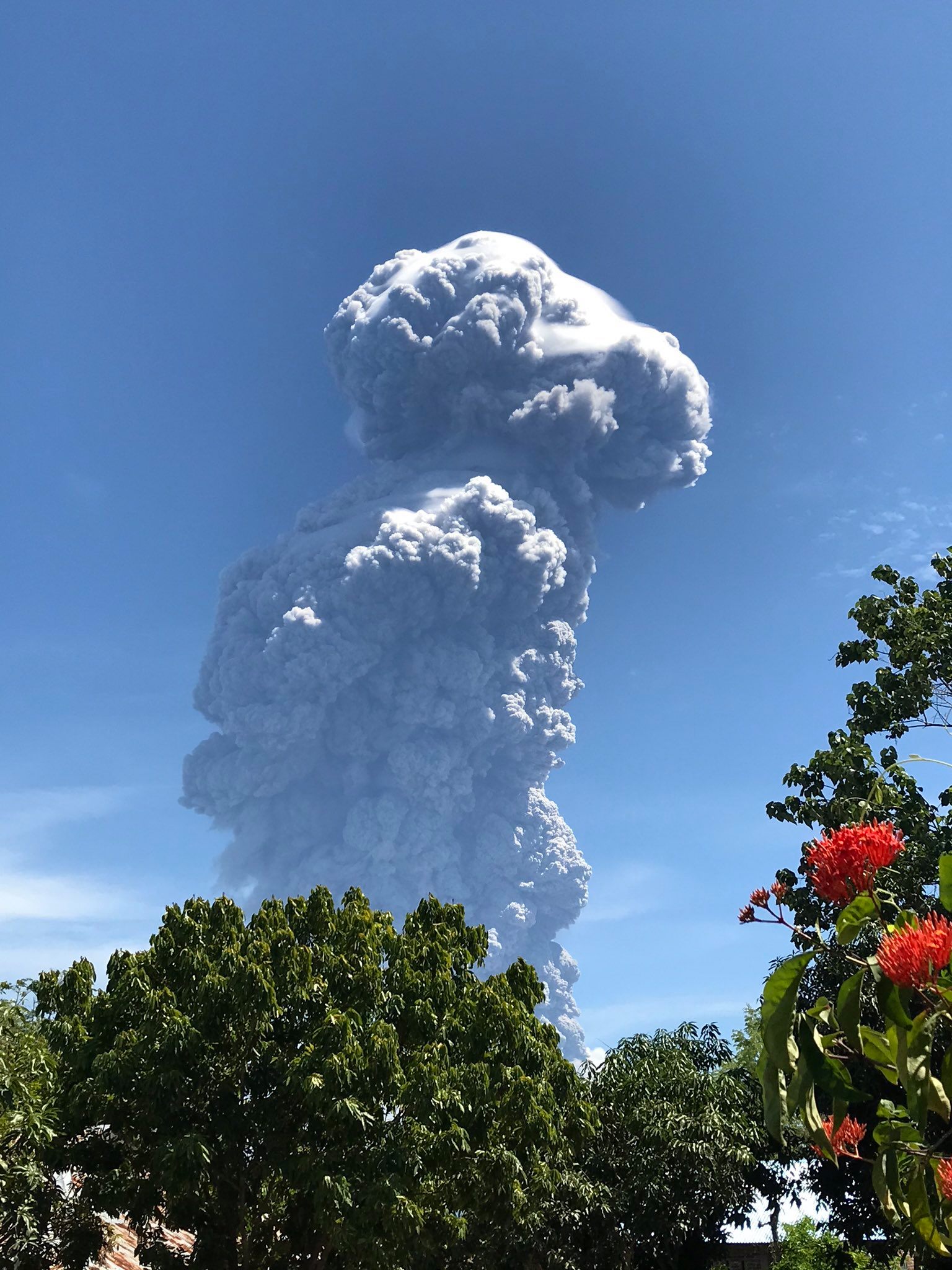
The Ili Lewotolok volcano (1018 m altitude) erupted on November 27, 2020 at 05:57 a.m. with a height of the gray / black ash column at 500 m above the summit (± 1923 m above the sea level) with a thick intensity, oriented towards West. This eruption was recorded on a seismogram with a maximum amplitude of 34 mm. The duration of the eruption was not clearly observed as it was followed by continuous tremors.
The results of the last day of monitoring showed that the volcano was clearly visible until it was covered in fog. We observe that the crater emits a white smoke with a strong thickness, about 500 meters above the summit. Incandescence was observed in the summit area. The weather is sunny / cloudy, the wind is weak in the South-West and North-West.
According to the seismographs of November 27, 2020, it was recorded:
1 eruption / emission earthquake
11 deep volcanic earthquake
1 local tectonic earthquake
Continuous tremor with an amplitude of 2-3 mm (dominant value 2 mm)
and on November 28, 2020 at 6 a.m., it was recorded:
2 deep volcanic earthquakes
Recommendation:
Communities around G. Ili Lewotolok and visitors / climbers / tourists should not climb and practice activities in the danger zone which is the crater area of Ili Lewotolok and in any areas within a radius of 2 km around from the summit / activity center of G Ili Lewotolok.

VOLCANO OBSERVATORY NOTICE FOR AVIATION – VONA.
Issued : Novembre 29 , 2020.
Volcano : Ili Lewotolok (264230)
Current Aviation Colour Code : ORANGE
Previous Aviation Colour Code : orange
Source : Ili Lewotolok Volcano Observatory
Notice Number : 2020LEW02
Volcano Location : S 08 deg 16 min 19 sec E 123 deg 30 min 18 sec
Area : East Nusa Tenggara, Indonesia
Summit Elevation : 4554 FT (1423 M)
Volcanic Activity Summary :
Eruption with volcanic ash cloud at 01h45 UTC (09h45 local). Eruption and ash emission is still ongoing.
Volcanic Cloud Height :
Best estimate of ash-cloud top is around 17354 FT (5423 M) above sea level, may be higher than what can be observed clearly. Source of height data: ground observer.
Other Volcanic Cloud Information :
Ash-cloud is moving in two directions. The lower level plume is moving west and the upper level plume is moving east.
Remarks :
Seismic activity is currently characterized by continuous volcanic tremor.
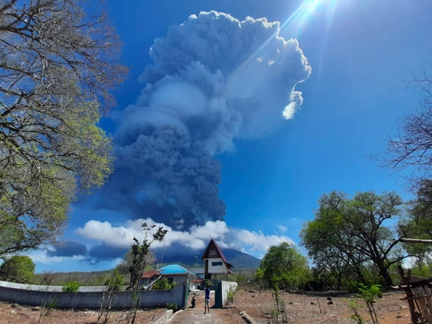
A second eruption occurred on November 29, 2020 at 9.45 a.m. WITA, with the height of the ash column observed to be gray to black, 4000 m above the summit (± 5423 m above sea level ) with a strong intensity, oriented towards the West at the bottom of the column and towards the East direction at the top of the column. This eruption was recorded on a seismogram with a maximum amplitude of 35 mm with an eruption duration of 10 minutes and was followed by continuous tremors.
Monitoring data indicates that the activity of Mount Ili Lewotolok is still high and has the potential to experience further eruptions.
Conclusion:
Based on the results of the global analysis, on November 29, 2020 at 1:00 p.m. WITA, the activity level of the Ili Lewotolok volcano was raised from level II (WASPADA) to level III (SIAGA)
Source : PVMBG .
Photos : magma indonesia , Rizal M .
Costa Rica , Turrialba / Poas / Rincon de la Vieja :
Turrialba volcano
Lat: 10.025 ° N; Long: 83.767 ° W;
Height: 3340 m.s.n.m.
Current activity level: 2 (active volcano)
Potentially associated hazards: gas, ash emission, proximal ballistic emissions.
No ash emission was observed. Seismic activity has decreased: the number of daily tremors and their duration have decreased. There is no significant deformation. The H2S / SO2 ratio is stable, the CO2 / SO2 and CO2 / Stot ratios remain at high values. The SO2 flow rate is maintained between 100 and 200 t / d. No thermal anomaly was detected by the MODIS analysis.
Poas volcano
Lat: 10.2 ° N; Long: 84.233 ° W;
Height: 2780 m.s.n.m.
Current activity level: 2 (active volcano)
Potentially associated hazards: gas, phreatic eruptions, proximal ballistic emissions.
No eruption was detected. Seismic activity remains stable at a high level, with 200 to over 300 events per day. There is no tremor but series of events of LP type. There is no significant deformation of the volcano. The H2S / SO2 ratio remains relatively high and the SO2 / CO2 ratio remains relatively low. The SO2 flux could not be measured due to an unfavorable wind direction. The level of the lake remained stable, the evaporation / infiltration rate remained low. On November 19, a proximal thermal anomaly of similar amplitude to that of January 2020 was detected by MODIS analysis.
Rincon de la Vieja volcano
Lat: 10.83 ° N; Long: 85.324 ° W;
Height: 1895 m.s.n.m.
Current activity level: 3 (erupting volcano)
Potentially associated hazards: gas, phreatic eruptions, proximal ballistic emissions, lahars.
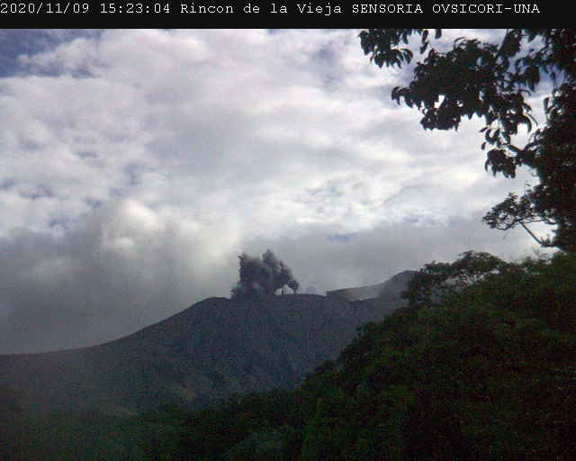
The volcano persists with frequent eruptions, 1,437 eruptions have been recorded since early 2020. These eruptions are more frequent (34 eruptions in one week) but are of low energy compared to previous months. The RSAM continues to oscillate, on November 23 the volcano entered an increasing phase despite a decrease in the amplitude of the tremor. 14 VT-type events were recorded towards the southern flank of the volcano between November 22 and 23. Geodetic monitoring shows a still significant contraction of the summit of the volcano. No thermal anomaly was detected by the MODIS analysis. Oxidation parameters (ORP) and electrical conductivity in the Santuario ojo (hot spring north of the
volcano) show a decreasing trend.
Source : Ovsicori.
Photos : G. Avard / Ovsicori , RSN , Ovsicori .
Kamchatka , Klyuchevskoy :
VOLCANO OBSERVATORY NOTICE FOR AVIATION (VONA).
Issued: November 29 , 2020 .
Volcano: Klyuchevskoy (CAVW #300260)
Current aviation colour code: ORANGE
Previous aviation colour code: orange
Source: KVERT
Notice Number: 2020-222
Volcano Location: N 56 deg 3 min E 160 deg 38 min
Area: Kamchatka, Russia
Summit Elevation: 15580 ft (4750 m)
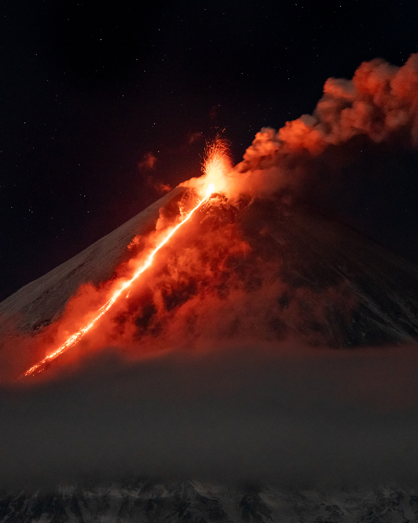
Volcanic Activity Summary:
A moderate explosive-effusive eruption of the volcano continues. According to video and satellite data, an ash plume on the height of 5.5-6.0 km a.s.l. is extending for 300 km to the east of the volcano.
This eruption of the volcano continues. Ash explosions up to 23,000-26,200 ft (7-8 km) a.s.l. could occur at any time. Ongoing activity could affect low-flying aircraft.
Volcanic cloud height:
18040-19680 ft (5500-6000 m) AMSL Time and method of ash plume/cloud height determination: 20201129/0410Z – Video data
Other volcanic cloud information:
Distance of ash plume/cloud of the volcano: 186 mi (300 km)
Direction of drift of ash plume/cloud of the volcano: ENE / azimuth 78 deg
Time and method of ash plume/cloud determination: 20201129/0203Z – JPSS-1 (14m15)
Source : Kvert .
Photo : Александр Панферов via Sherine France.
Philippines , Taal :
TAAL VOLCANO BULLETIN 29 November 2020 08:00 A.M.
In the past 24-hour period, the Taal Volcano Network recorded three (3) volcanic earthquakes. Emission of steam-laden plumes from fumarolic activity at the vents of the Main Crater was weak. Ground deformation parameters based on continuous GPS monitoring from 29 March 2020 to present indicated a slow and slight inflation of the northwestern sector of Taal Caldera, which was also recorded by electronic tilt on northwest Volcano Island starting the second week of July 2020. In contrast, GPS data from the southwestern sector of Taal Caldera and Volcano Island yielded no significant change after the huge post-eruption subsidence.

Alert Level 1 (Abnormal) is maintained over Taal Volcano. DOST-PHIVOLCS reminds the public that at Alert Level 1, sudden steam-driven or phreatic explosions, volcanic earthquakes, minor ashfall, and lethal accumulations or expulsions of volcanic gas can occur and threaten areas within the Taal Volcano Island (TVI). DOST-PHIVOLCS strongly recommends that entry into TVI, Taal’s Permanent Danger Zone or PDZ, especially the vicinities of the Main Crater and the Daang Kastila fissure, must remain strictly prohibited. Local government units are advised to continuously assess previously evacuated barangays around Taal Lake for damages and road accessibilities and to strengthen preparedness, contingency, and communication measures in case of renewed unrest. People are also advised to observe precautions due to ground displacement across fissures, possible ashfall, and minor earthquakes. Civil aviation authorities must advise pilots to avoid flying close to the volcano as airborne ash and ballistic fragments from sudden explosions and wind-remobilized ash may pose hazards to aircraft.
DOST-PHIVOLCS is closely monitoring Taal Volcano’s activity and any new significant development will be immediately communicated to all stakeholders.
Source : Phivolcs
Photo : Tomasz Lepich