December 12 , 2019.
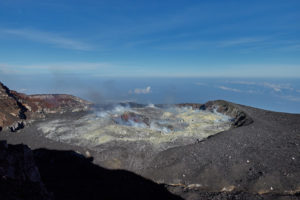
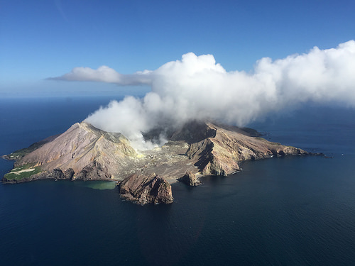
New Zealand , White Island :
Volcanic Alert BulletinWI – 2019/19 ,Thu Dec 12 2019 10:20 AM; White Island Volcano
Volcanic Alert Level is lowered to 2
Aviation Colour Code remains at Orange
The Volcanic Alert Level is reduced to Level 2. There has not been any further eruptive activity since Monday’s fatal eruption. The likelihood of future eruptive activity in the next 24 hours remains. Overnight, volcanic tremor increased to very high levels.
Since the eruption on Monday, there have been no further eruptive activity. As there has been no further eruption since 2:11 pm Monday, we have lowered the Volcanic Alert Level to Level 2. Alert Level 2 indicates moderate to heightened unrest with potential for eruption hazards. The NZ Volcanic Alert Level System reflects the current state of the volcano and does not provide a forecast of future activity.
The likelihood of future eruptive activity in the next 24 hours remains. Since early Tuesday morning, volcanic tremor has been rising and is now at very high levels. We are still observing steam and mud jetting from the active vents.
The combined interpretation of our data is that the situation remains highly volatile.

Volcanic Alert BulletinWI – 2019/19, Thu.12 Dec.2019 17:00; White Island Volcano
The volcanic alert level remains at 2
The color code of aviation remains in Orange
Volcanic tremor remains high, however no further eruptions have occurred since Monday 9 December. There is a medium likelihood (50-60%) of future eruptive activity in the next 24 hours. The Volcanic Alert Level remains at Level 2.
Since the eruption on Monday, there has been no further eruptive activity. In the last few hours, volcanic tremor has decreased but it is still very high compared to normal levels. Vigorous steam and mud bursts continue from the active vent area.
The combined interpretation of our data is that magma is degassing at shallow depths and the situation remains highly volatile.
Another gas flight was completed today, and the data is currently being analysed to support our ongoing understanding of the volcano.
There is still a medium likelihood (50-60%) of eruptive activity in the next 24 hours. We have updated the eruption probability table.
There is an extremely low likelihood of any potential ash affecting the mainland, but people may smell gas, depending on the prevailing wind direction.
Our monitoring equipment continues to function and is providing us with continuous data on the volcano’s activity.
GNS Science and our National Geohazards Monitoring Centre continue to closely monitor Whakaari/White Island for further signs of activity. Volcanic Alert Level 2 indicates moderate to heightened unrest with potential for eruption hazards.
Source : Geonet / Geoff Kilgour / Duty Volcanologist .
Photo : David McClelland , mynewzealand.co.nz .
Ecuador , Sangay :
2.005°S, 78.341°W
Elevation 5286 m
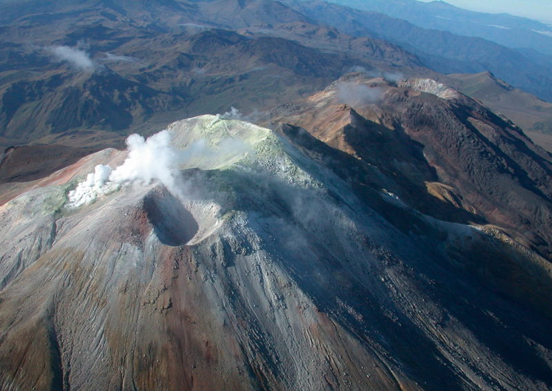
IG reported that the eruption at Sangay that began on 7 May was continuing as of 4 December without a notable increase or decrease in activity levels. Activity was concentrated at two eruptive centers: the Central Crater and the Ñuñurcu dome (located 190 m SSE of Central Crater). Sporadic explosions at Central Crater produced ash plumes that rose as high as 2 km above the crater rim and drifted mainly NE during the previous month. Minor ashfall was recorded in the towns of Alao (20 km NW), Cebadas (35 km WNW), and Guaguallá (Chimborazo province), in Macas (42 km SSE, Morona-Santiago province), and in the Azuay province. Almost continuous lava effusion from the Ñuñurcu dome fed lava flows that traveled down the SE flank.
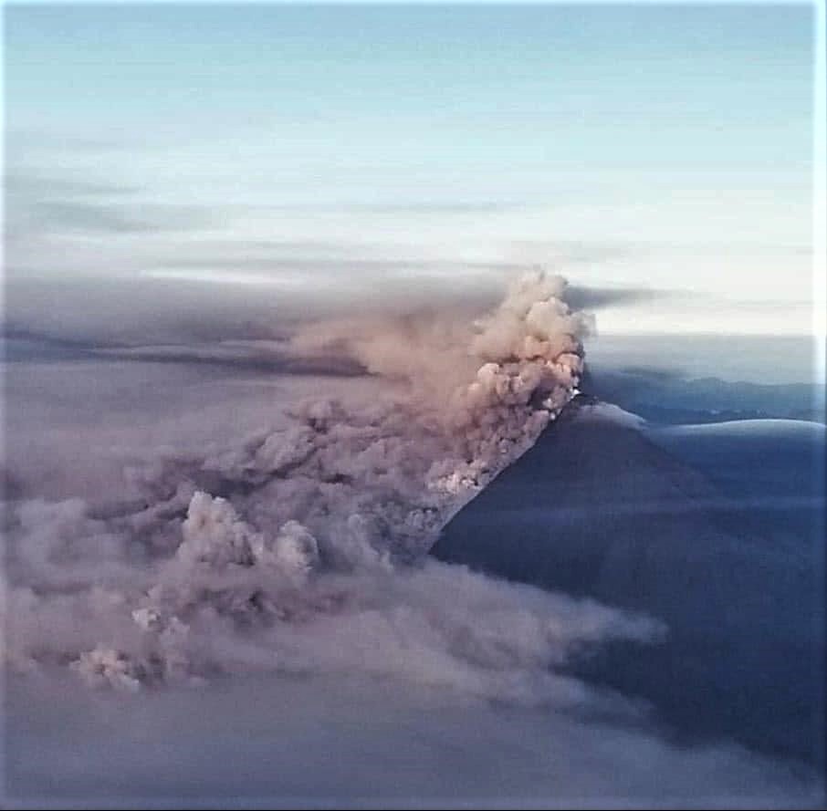
Collapses along the margins of the lava flows generated small pyroclastic flows and small rockfalls that reached the upper channel of the Río Volcán. These deposits created dams which were remobilized by rainfall into lahars, which in turn partially dammed parts of the river at the confluence of the Río Upano. Parque Nacional Sangay and IG-EPN staff measured deposits at the confluence that were more than 2 m thick on 27 November; similar deposits were observed along a 16-km stretch upsteam. Sulfur dioxide emissions up to 640 tons/day were detected by satellite in recent weeks, and a strong sulfur odor was noted around 1 km above the crater rim during a 3 December overflight.
Source: Instituto Geofísico-Escuela Politécnica Nacional (IG) , GVP.
Photo : Leoquina San Fernando via Sherine France.
Colombia , Cumbal :
Cumbal volcanic complex weekly activity bulletin
The activity of the Cumbal volcanic complex continues at the level: YELLOW LEVEL ■ (III): CHANGES IN THE BEHAVIOR OF VOLCANIC ACTIVITY.
Following the activity of the CUMBAL VOLCANIC COMPLEX, the COLOMBIAN GEOLOGICAL SERVICE (SGC) reports that:
For the period evaluated between December 3 and December 9, 2019, the seismicity of the volcanic complex remained at low levels, with an increase compared to the previous week, the most frequent earthquakes being those related to the fracturing of rocks in the interior of the volcanic complex, 54% of the total, followed by those related to fluid movements, 43%.
The recorded events showed a low energy release, a maximum local magnitude of M 0.2. Localized earthquakes are dispersed at distances up to 4.4 km and at depths less than 7 km from the summit (4,700 meters above sea level).
Throughout the week, it was possible to record gas emissions from the El Verde fumarole field to the northeast of Plazuelas crater, El Rastrojo and other fumarole fields located south of Mundo Nuevo crater, with white columns, of variable height and dispersion varying by the action of the wind.
The other volcanic monitoring parameters did not show significant variations.
Source et photo : SGC.
Italy , Stromboli :
Weekly bulletin from December 02 , 2019 to December 08 , 2019 (date of issue December 10 , 2019)
SUMMARY OF STATUS OF ACTIVITY
In light of the surveillance data, we highlight:
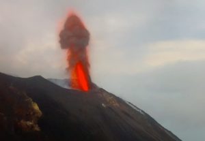
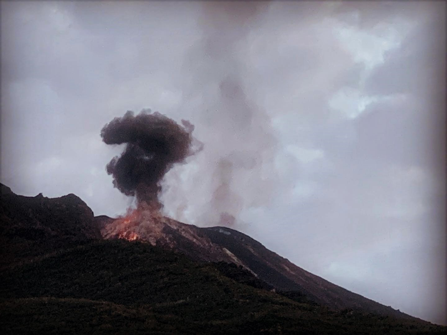
1) VOLCANOLOGICAL OBSERVATIONS: During this period, a normal explosive activity of Strombolian type was observed accompanied by degassing and splashing activities. The hourly frequency of explosions fluctuated between average values (12 events / h day December 6) and high values (24 events / h day December 8). The intensity of the explosions was mainly medium-low in the North crater area and medium in the South-Central Crater area.
2) SEISMOLOGY: The seismological parameters do not show significant changes.
4) DEFORMATIONS: There is no significant change regarding permanent GPS and tilt networks.
5) GEOCHEMISTRY: the flow of SO2 is at a medium-high level. The isotopic ratios of helium dissolved in the thermal stratum remain unchanged on the medium-low values (analysis of 11/18/2019).
VOLCANOLOGICAL OBSERVATIONS.
The analysis of the images recorded by the cameras placed at 400 meters, at 190 meters and at Punta dei Corvi allowed us to characterize the eruptive activity of Stromboli. During the period under review, the explosive activity was produced, mainly, by at least 3 (three) eruptive vents located in the area of the North crater and by at least 3 (three) eruptive vents located in the area of the Center crater -South. All the mouths are placed inside the depression which occupies the terrace of the crater.
In the North zone, the explosions were mainly of low intensity (less than 80 m high) and medium (less than 150 m high) emitting coarse materials (lapilli and bombs). In many explosions, relapses have covered the outer slopes of the area facing the Sciara del Fuoco and some blocks have rolled a few hundred meters to the mesa in place along the Sciara. On December 4 from the mouths located in the southern part of the northern zone, a splash was observed, sometimes intense. The average frequency of the explosions was variable between 6 and 11 events / h. The explosive activity of the Center-South zone produced explosions of coarse material, sometimes mixed with an average intensity (less than 150 m in height). In some explosions, the products fell back into the upper part of the Sciara. The frequency of explosions in the Center-South zone varied between 6 and 13 events / h.
Source : INGV.
Read the full article : file:///C:/Users/Utilisateur/AppData/Local/Packages/Microsoft.MicrosoftEdge_8wekyb3d8bbwe/TempState/Downloads/BollettinoStromboli20191210%20(1).pdf
Photo : stromboli aventures