November 22, 2020. EN . Italy : Stromboli , Indonesia : Sinabung , Chile : Villarica , Mexico : Popocatepetl .

November 22 , 2020 .


Italy , Stromboli :

PRESS RELEASE ON THE EXPLODED ACTIVITY OF NOVEMBER 21, 2020 h. 00:33 UTC (01:33 local time) – NEW MAJOR EXPLOSION

On November 21, 2020, at 00:33:21 hours UTC, the geophysical monitoring network recorded a very strong explosive event, associated with seismic parameters (1.05 x10- 4 m / s in speed and 1.24 x10- 5 m in displacement and soil deformation (0.41 mrad at the OHO reference tiltmeter in the Rina Grande) above ordinary explosive activity, the event falling within the lower limits of the major explosion field.
This explosive event was preceded by about 3 minutes of clear inflation of the soils.


The infrastructure network located the explosive event in the area of the southwest crater, but nevertheless indicates modest infrasound pressures (figure 1) around 45 Pa (at 450 m), compatible with a limited emission of pyroclastic products, as thermal images show.
Following the explosive event, no significant change in explosive activity was observed. All stations are functioning properly.


The photo above was taken by staff of the INGV-Etneo Observatory during a helicopter overflight (provided by the 2nd Catania Coast Guard Air Force Unit) on 11 November 2020, after the explosion the night before.

N.B. The paroxysmal explosion warning system was and still is in operation. This explosion (major and not paroxysmal) exceeded the width criterion (0.3 microrad) provided for by the Early – Paroxysmal Warning system but not that on the duration of the soil inflation before the paroxysmal explosions, so it was not surmounted the threshold of 0.85 provided by the automatic system to trigger the warning system.

Source: Laboratorio di Geofisica Sperimentale del Dipartimento di Scienze della Terra – Università di Firenze


Indonesia , Sinabung :

VOLCANO OBSERVATORY NOTICE FOR AVIATION – VONA.

Issued : November 21 , 2020
Volcano : Sinabung (261080)
Current Aviation Colour Code : ORANGE
Previous Aviation Colour Code : orange
Source : Sinabung Volcano Observatory
Notice Number : 2020SIN31
Volcano Location : N 03 deg 10 min 12 sec E 98 deg 23 min 31 sec
Area : North Sumatra, Indonesia
Summit Elevation : 7872 FT (2460 M)


Volcanic Activity Summary :
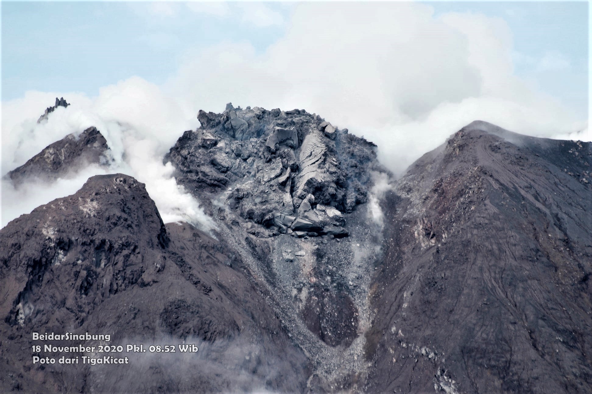
Eruption with volcanic ash cloud at 14h37 UTC (21h37 local).

Volcanic Cloud Height : Ash-cloud is not visible

Other Volcanic Cloud Information :volcano cloudy

Remarks : Seismic activity is characterized by eruption volcanic event


The activity level has been at level III (SIAGA) since May 20, 2019 at 10:00 a.m. WIB. The Sinabung volcano (2460 m altitude) has been erupting since 2013.

The volcano was clearly visible until it was covered in fog. Smoke from the crater was not observed. The weather is sunny / rainy, with weak to strong winds in the North-East, East and South-East. The air temperature is around 16-22 ° C.

According to the seismographs of November 21, 2020, it was recorded:
• 1 eruption / explosion earthquake
• 29 avalanche earthquakes
• 3 Tornillo-type earthquakes
• 17 low frequency earthquakes
• 1 Distant tectonic earthquake

Recommendation:
• Communities and visitors / tourists should not conduct activities in villages that have been relocated, as well as within a radial radius of 3 km around the summit of G. Sinabung, and a sector radius of 5 km for the sector. South-East and 4 km for the North-East sector.

Source : Magma Indonésie , PVMBG.

Photo : Nachelle Homestay , Firdaus Surbakti .


Chile , Villarica :

216 earthquakes related to fluid dynamics within the volcanic building were recorded, classified as long period type events (LP), with a maximum reduced displacement (DR) of 20 cm2.
– The seismic recordings were dominated by a continuous tremor signal also related to the dynamics of the fluids inside the volcano, which presented oscillations related to the surface activity recorded between November 5 and 10, with a value Average DR equal to 4 cm2 and maximum values ​​close to 9 cm2
. The spectral content of the signal varied from 0.7 to 7.0 Hz, mainly between 3 and 7 Hz.
– The infrasound sensors installed near the volcano recorded acoustic signals associated with explosions at the level of the crater, with maximum values ​​of 9.4 Pa (reduced to 1 km as a reference), a value deemed moderate for the volcano. The recording of these signals increased between November 6 and 8.
– Two earthquakes classified as volcano-tectonic (VT) were recorded, associated with fracturing processes of rigid materials. The most important event had a local magnitude (ML) of 1.4 and was located 6.9 km to the south (S), with a depth of 3.2 km from the main crater.
– According to the data provided by the 3 GNSS stations, which measure the surface deformation of the volcanic environment, there are no variations suggesting changes in the internal dynamics of the volcano.

– Two anomalies were reported in sulfur dioxide (SO2) emissions into the atmosphere in the area near the volcanic building on November 7 and 11, according to data released by the Tropospheric Monitoring Instrument (TROPOMI) and Ozone Monitoring Instrument (IMO).
– 4 thermal alerts were recorded in the area associated with the volcanic building, with a maximum volcanic radiative power (VRP) of 24 MW on November 8, this anomaly was associated with an explosion; this value is considered moderate according to data processed by Middle Infrared Observation of Volcanic Activity (MIROVA) and by near real-time thermal monitoring of global hot spots (MODVOLC). Sentinel 2-L2A satellite images detected 2 radiation anomalies associated with the crater area on November 9 and 14.

The evolution towards a Strombolian dynamic, for example on November 6, is associated with the rupture of the crust which covers the lava lake, which rises, generating a partial degassing (as experienced on November 7). This mechanism of ascent of the lava lake would be evidenced by the reappearance of thermal radiation anomalies in the Sentinel L2 A images and the report of observations of the lava lake; however, it is considered to have remained relatively deep.

The period evaluated was characterized by a tremor signal which dominates the seismic recording and with a spectral content towards the high frequencies, which would be linked to partial obstructions of the degassing duct (s) and to a rise of magma. , allowing overpressures that trigger explosions such as those recorded on November 6.


In the discovery of these obstructions, based on the current history, it is suggested as an initial hypothesis that two trigger mechanisms could coexist, influenced by the level of obstruction of the lava lake:

1. The rupture of the crust that covers the lava lake, influenced by the rise of magma with a higher content of volatiles, due to a convection mechanism in the magma column without apparent input of new material,

2. The detachment of the blocks from inside the conduit due to the instability caused by the depth of the lava lake, falling into the magmatic column, generating a sharp increase in the accumulation of bubbles, increasing their explosiveness.

The calculated data for SO2 gas and thermal anomalies of satellites are considered low. This could indicate that this activity most likely has a superficial stimulus at the expense of a deeper contribution. With all of the above, it is emphasized that the system continues with the possibility of generating minor explosions that affect the area near the crater. It should be noted that the behavior of the lava lake is fluctuating, and that it continues to be located at surface level, causing minor explosions that can affect the proximity of the crater.

Consequently, the technical alert is maintained at the level:
YELLOW TECHNICAL ALERT: Changes in the behavior of volcanic activity.

Source : Sernageomin .

Photos : volcanologia en chile , Franco Vera.


Mexico , Popocatepetl :

November 21, 11:00 a.m. (November 21, 5:00 p.m. GMT)

During the last 24 hours, according to the monitoring systems of the Popocatépetl volcano, 415 exhalations accompanied by water vapor and volcanic gases have been identified. 30 minutes of low amplitude tremor were also recorded.

At the time of this report, there is visibility towards the volcano, during the morning an emission of water vapor and volcanic gases was observed with a northwest direction.

CENAPRED urges not to approach the volcano and in particular the crater, because of the danger posed by the fall of ballistic fragments and, in the event of heavy rains, to stay away from the bottom of the ravines because of the danger mudslides and debris.

The Popocatépetl volcanic alert semaphore is on YELLOW PHASE 2.

Source : Cenapred .


22 Novembre 2020 . FR . Italie : Stromboli , Indonésie : Sinabung , Chili : Villarica , Mexique : Popocatepetl .

22 Novembre 2020 .


Italie , Stromboli :

COMMUNIQUÉ SUR L’ACTIVITÉ EXPLOSE DU 21 NOVEMBRE 2020 h. 00:33 UTC (01:33 heure locale) – NOUVELLE EXPLOSION MAJEURE

Le 21 novembre 2020, à 00:33:21 heures UTC, le réseau de surveillance géophysique a enregistré un événement explosif très fort, associé à des paramètres sismiques (1.05 x10- 4 m / s en vitesse et 1.24 x10- 5 m en déplacement et déformation des sols (0.41 mrad au tiltmètre de référence OHO dans la Rina Grande) au-dessus de l’activité explosive ordinaire. L ‘ événement tombe dans les limites inférieures du champ d’explosions majeures.
Cet événement explosif a été précédé d’environ 3 minutes d’une inflation claire des sols.
 
 
Le réseau d’infrastructure a localisé l’événement explosif dans la zone du cratère Sud-Ouest , mais indique cependant des pressions infrasonores (figure 1) modestes autour de 45 Pa (à 450 m), compatibles avec une émission limitée de produits pyroclastiques , comme le montrent les images thermiques.
À la suite de l’événement explosif, aucune variation significative de l’activité explosive n’a été observée. Toutes les stations fonctionnent correctement.
 
 
La photo ci-dessus a été prise par le personnel de l’Observatoire INGV-Etneo lors d’un survol en hélicoptère (mis à disposition par la 2e unité de l’armée de l’air des garde-côtes de Catane) le 11 novembre 2020, après l’explosion de la veille au soir.
 
N.B. Le système d’alerte des explosions paroxystiques était et est toujours en marche. Cette explosion (majeure et non paroxystique) a dépassé le critère de largeur (0.3 microrad) prévu par le système Early – Warning Paroxystique mais pas celui sur la durée de l’inflation des sols avant les explosions paroxystiques, donc elle n’a pas été surmontée le seuil de 0.85 prévu par le système automatique pour déclencher le système d’alerte.
 
Source: Laboratorio di Geofisica Sperimentale del Dipartimento di Scienze della Terra – Università di FirenzeLire l’article: ESPLOSIONE MAGGIORE A STROMBOLI DEL 21/11/2020 00:33:21 UTC (unifi.it)

Photo : INGV.


Indonésie , Sinabung :

AVIS D’OBSERVATION DU VOLCAN POUR L’AVIATION – VONA.

Diffusion: 21 novembre 2020
Volcan: Sinabung (261080)
Code couleur de l’aviation actuel: ORANGE
Code couleur de l’aviation précédent: orange
Source: Observatoire du volcan Sinabung
Numéro de l’avis: 2020SIN31
Emplacement du volcan: N 03 deg 10 min 12 sec E 98 deg 23 min 31 sec
Région: North Sumatra, Indonésie
Altitude du sommet: 7872 FT (2460 M)


Résumé de l’activité volcanique:
Éruption avec nuage de cendres volcaniques à 14h37 UTC (21h37 local).

Hauteur du nuage volcanique: le nuage de cendres n’est pas visible

Autres informations sur les nuages volcaniques: volcan nuageux

Remarques: l’activité sismique est caractérisée par un événement volcanique éruptif .


Le niveau d’activité est au niveau III (SIAGA) depuis le 20 mai 2019 à 10h00 WIB. Le volcan Sinabung (2460 m d’altitude) est en éruption depuis 2013.

Le volcan était clairement visible jusqu’à ce qu’il soit couvert de brouillard. La fumée issue du cratère n’a pas été observée. Le temps est ensoleillé / pluvieux , les vents faibles à forts au Nord-Est, à l’Est et au Sud-Est. La température de l’air est d’environ 16-22 ° C.

Selon les sismographes du 21 novembre 2020, il a été enregistré:
• 1 tremblement de terre d’éruption / explosion 
• 29 tremblements de terre d’avalanches
• 3  tremblements de terre de type Tornillo
• 17  tremblements de terre à basse fréquence
• 1 séisme tectonique Lointain

Recommandation:
• Les communautés et les visiteurs / touristes ne doivent pas mener d’activités dans les villages qui ont été relocalisés, ainsi que dans un rayon radial de 3 km autour du sommet du G. Sinabung, et un rayon sectoriel de 5 km pour le secteur Sud-Est et de 4 km pour le secteur Nord-Est .

Source : Magma Indonésie , PVMBG.

Photo : Nachelle Homestay , Firdaus Surbakti .


Chili , Villarica :

216 tremblements de terre liés à la dynamique des fluides au sein du bâtiment volcanique ont été enregistrés, classés comme événements de type longue période (LP), avec un déplacement réduit maximum (DR) de 20 cm2.
– Les enregistrements sismiques ont été dominés par un signal de tremor continu également lié à la dynamique des fluides à l’intérieur du volcan, qui présentait des oscillations liées à l’activité de surface enregistrée entre le 5 et le 10 novembre, avec une valeur DR moyenne égale à à 4 cm2 et des valeurs maximales proches de 9 cm2
. Le contenu spectral du signal variait de 0,7 à 7,0 Hz, principalement entre 3 et 7 Hz.
– Les capteurs infrasons installés à proximité du volcan ont enregistré des signaux acoustiques associés à des explosions au niveau du cratère, avec des valeurs maximales de 9,4 Pa (réduites à 1 km comme référence), une valeur jugée modérée pour le volcan. L’enregistrement de ces signaux a augmenté entre le 6 et le 8 novembre.
– Deux tremblements de terre classés comme volcano-tectoniques (VT) ont été enregistrés, associés à des processus de fracturation de matériaux rigides. L’événement le plus important avait une magnitude locale (ML) égale à 1,4 et était situé à 6,9 km au Sud (S), avec une profondeur de 3,2 km par rapport au cratère principal.
– D’après les données fournies par les 3 stations GNSS, qui mesurent la déformation de surface de l’environnement volcanique, il n’y a pas de variations suggérant des changements dans la dynamique interne du volcan.

– Deux anomalies ont été signalées dans les émissions de dioxyde de soufre (SO2) dans l’atmosphère dans le secteur proche du bâtiment volcanique, les 7 et 11 novembre, selon les données publiées par le Tropospheric Monitoring Instrument (TROPOMI) et Ozone Monitoring Instrument ( OMI) .
– 4 alertes thermiques ont été enregistrées dans la zone associée au bâtiment volcanique, avec une puissance radiative volcanique (VRP) maximale de 24 MW le 8 novembre, cette anomalie a été associée à une explosion; cette valeur est considérée comme modérée selon les données traitées par Middle Infrared Observation of Volcanic Activité (MIROVA) et par surveillance thermique en temps quasi réel des points chauds mondiaux (MODVOLC)  . Les images satellites Sentinel 2-L2A ont détecté 2 anomalies de rayonnement associées à la zone du cratère les 9 et 14 novembre.

L’évolution vers une dynamique strombolienne, par exemple le 6 novembre, est associée à la rupture de la croûte qui recouvre le lac de lave, qui remonte, générant un dégazage partiel (comme vécu le 7 novembre). Ce mécanisme d’ascension du lac de lave serait mis en évidence par la réapparition d’anomalies de rayonnement thermique dans les images Sentinel L2 A et le rapport d’observations du lac de lave; cependant, on considère qu’il est resté relativement profond.

La période évaluée a été caractérisée par un signal de tremor qui domine l’enregistrement sismique et avec un contenu spectral vers les hautes fréquences, qui serait lié à des obstructions partielles du (des) conduit (s) de dégazage et à une remontée de magma, permettant des surpressions qui déclenchent des explosions telles que celles enregistrés le 6 novembre.


Dans la découverte de ces obstructions, selon les antécédents actuels, il est suggéré comme hypothèse initiale où deux mécanismes de déclenchement pourraient coexister, influencés par le niveau d’obstruction du lac de lave:

1. La rupture de la croûte qui recouvre le lac de lave, influencé en raison de la remontée du magma avec une teneur plus élevée en volatils, en raison d’un mécanisme de convection dans la colonne de magma sans apport apparent de nouveau matériau,

2. Le détachement des blocs de l’intérieur du conduit en raison de l’instabilité causée par la profondeur du lac de lave, tombant dans la colonne magmatique, générant une augmentation brutale de l’accumulation de bulles, augmentant leur explosivité.

Les données calculées pour le gaz SO2 et les anomalies thermiques des satellites sont considérées comme faibles. Cela pourrait indiquer que cette activité a très probablement un stimulus superficiel au détriment d’une contribution plus profonde. Avec tout ce qui précède, il est souligné que le système continue avec la possibilité de générer des explosions mineures qui affectent la zone près du cratère. Il est à noter que le comportement du lac de lave est fluctuant, et qu’il continue d’être situé au niveau de la surface, provoquant des explosions mineures pouvant affecter la proximité du cratère.

Par conséquent, l’alerte technique est maintenue au niveau :
ALERTE TECHNIQUE JAUNE: Modifications du comportement de l’activité volcanique.

Source : Sernageomin .

Photos : volcanologia en chile , Franco Vera.


Mexique , Popocatepetl :

21 novembre, 11h00 (21 novembre, 17h00 GMT)

Au cours des dernières 24 heures, selon les systèmes de surveillance du volcan Popocatépetl, 415 exhalaisons accompagnées de vapeur d’eau et de gaz volcaniques ont été identifiées  . 30 minutes de tremor de faible amplitude ont également été enregistrées.

Au moment de ce rapport , il y a de la visibilité vers le volcan, au cours de la matinée une émission de vapeur d’eau et de gaz volcaniques a été observée avec une direction Nord-Ouest .

Le CENAPRED exhorte à ne pas s’approcher du volcan et en particulier du cratère, en raison du danger posé par la chute de fragments balistiques et, en cas de fortes pluies, de rester à l’écart du fond des ravins en raison du danger de coulées de boue et de débris.

Le sémaphore d’alerte volcanique du Popocatépetl est sur la PHASE JAUNE 2.

Source : Cenapred .