May 20 , 2023.
Italy / Sicily , Etna :
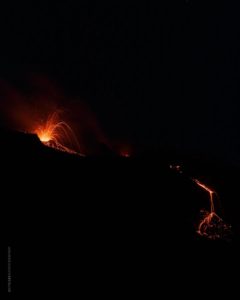
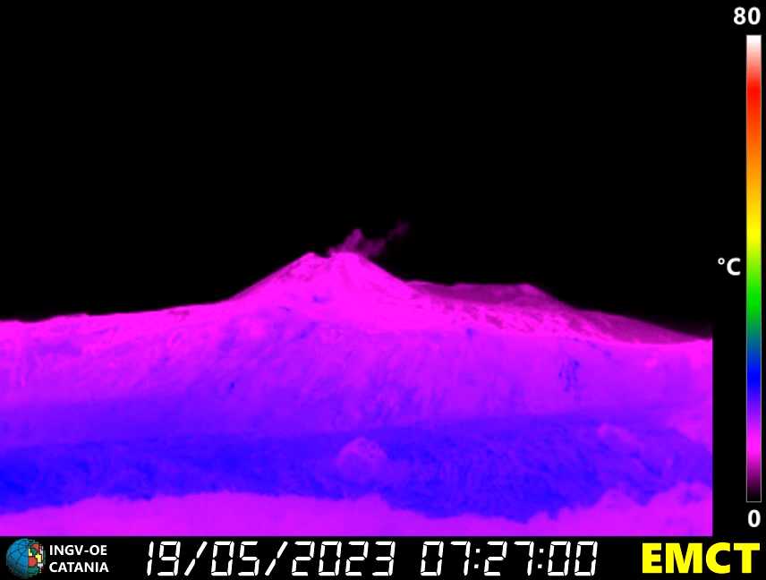
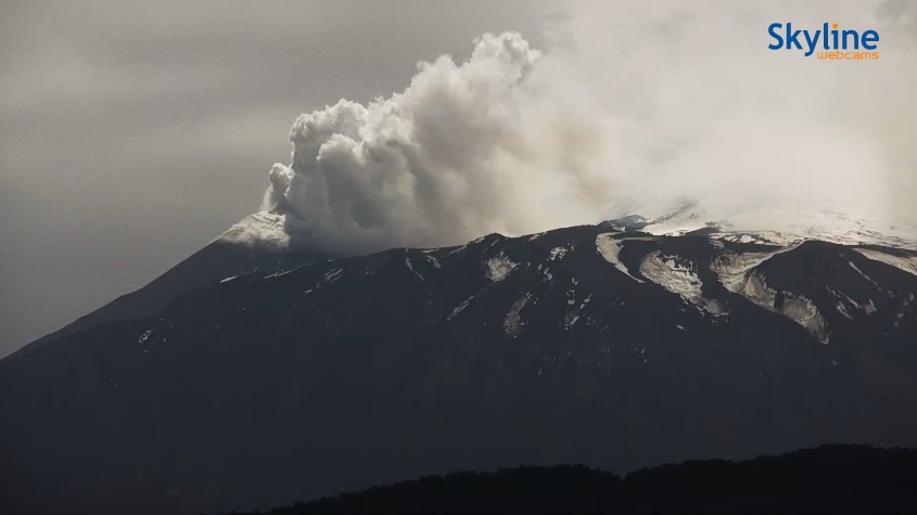
Communique on the activity of Etna, May 19, 2023, 09:27 (07:27 UTC).
The National Institute of Geophysics and Volcanology, Osservatorio Etneo, communicates that from the analysis of the images of the network of surveillance cameras, it is observed that a weak intra-crater Strombolian activity is present in the crater South- East.
The volcanic tremor after the maximum amplitude reached around 15:00 UTC yesterday, showed large oscillations and is currently in a decreasing phase. After yesterday’s swarm ended, only a few low-energy seismic events were recorded.
From the infrasound point of view, the activity is rare and the few localized events are in correspondence with the Southeast Crater and the Bocca Nuova.
With regard to ground deformations, after the slow and modest decompression phase recorded in the tension in the morning and early afternoon of yesterday (May 18) and after the variations of the inclinometer stations and the summit deformations recorded during the seismic swarm yesterday afternoon, since yesterday evening there have been no significant changes and the signals from the permanent GNSS networks and inclinometers are stable.
Communique on the activity of Etna, May 19, 2023, 15:38 (13:38 UTC).
The National Institute of Geophysics and Volcanology, Osservatorio Etneo, communicates that from the analysis of images from the network of surveillance cameras, a pulsed degassing of the Southeast Crater is observed. From the volcanic ash dispersion forecast model, the simulation of the possible dispersion of the volcanic plume indicates a North-North-East direction.
In the hours following the previous press release, the volcanic tremor remained at high values with an upward trend. Three of the systems contributing to the Etnas system (tremor and infrasonic) are at level 1.
In the last hours since the previous press release, the permanent GNSS networks and deformation control inclinometers have not recorded any significant variations.
Further updates will be communicated soon.
Source : INGV.
Photos : INGV.
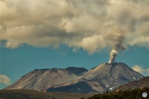
Indonesia , Merapi :
Report on the activity of Mount Merapi from May 12, 2023 to May 18, 2023, Published on May 19, 2023
RESULTS OF OBSERVATIONS
Visual
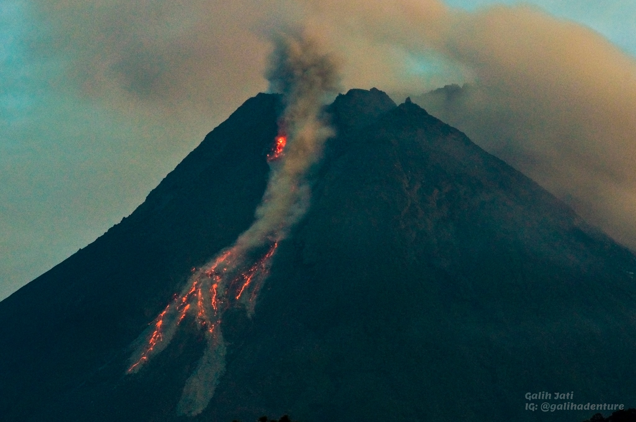
The weather around Mount Merapi is usually sunny in the morning and afternoon, while the evening is foggy. White, fine to thick, low to medium pressure, 75 m high white smoke was observed from the Mount Merapi observation post in Selo on May 14, 2023 at 10:00 a.m.
This week, lava avalanches were observed 182 times to the southwest (upstream of Kali Bebeng and Kali Boyong) with a maximum slip distance of 1,800 m, and 1 time to the northwest (upstream of Kali Senowo) with a sliding distance of 500m. The sound of the avalanches was heard 17 times from Babadan post with low to moderate intensity.
On the Southwest dome, the Lava 1948 and Lava 1888 domes observed morphological changes were observed due to lava avalanches. For the central dome, there is no significant change. The results of the drone survey showed an increase in the volume of the dome, the measured volume of the southwest dome was 2,372,800 m3 and the middle dome was 2,337,300 m3.
Seismicity
This week, the seismicity of Mount Merapi showed:
13 deep volcanic earthquakes (VTB),
809 avalanche earthquakes (RF),
4 tectonic earthquakes (TT).
30 multi-phase (MP) earthquakes
1 low frequency earthquakes (LF).
In general, the intensity of seismicity this week is higher than last week.
Deformation
Mount Merapi’s deformation that was monitored using EDM and GPS this week showed a shortening rate of 0.07 cm/day.
Rain and lahars:
This week, there was no rain at the Mount Merapi observation post and no additional flows were reported in the rivers that descend from Mount Merapi.
Conclusion
Based on the results of visual and instrumental observations, it is concluded that:
-The volcanic activity of Mount Merapi is still quite high in the form of effusive eruption activity. The state of the activity is defined at the « SIAGA » level.
The current danger potential is in the form of lava avalanches and hot clouds in the South-South-West sector comprising the Boyong River for a maximum of 5 km, the Bedog, Krasak, Bebeng rivers for a maximum of of 7 km. In the South-East sector, it includes the Woro River for a maximum of 3 km and the Gendol River for 5 km. While the ejection of volcanic material in the event of an explosive eruption can reach a radius of 3 km from the summit.
Source : BPPTKG
Photo : Yohannes Tyas Galih Jati
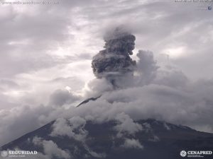
Indonesia , Ili Lewotolok :
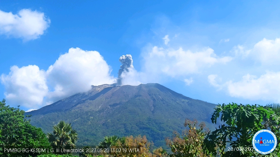
An eruption of G. Ili Lewotolok occurred on Saturday, May 20, 2023 at 1:07 p.m. WITA with the height of the ash column observed at ± 600 m above the summit (± 2023 m above sea level) . The ash column was observed to be white to gray with a thick intensity, oriented towards the northeast.
VOLCANO OBSERVATORY NOTICE FOR AVIATION – VONA
Issued : May 20 , 2023.
Volcano : Ili Lewotolok (264230)
Current Aviation Colour Code : ORANGE
Previous Aviation Colour Code : orange
Source : Ili Lewotolok Volcano Observatory
Notice Number : 2023LEW027
Volcano Location : S 08 deg 16 min 19 sec E 123 deg 30 min 18 sec
Area : East Nusa Tenggara, Indonesia
Summit Elevation : 4554 FT (1423 M)
Volcanic Activity Summary :
Eruption with volcanic ash cloud at 05h07 UTC (13h07 local).
Volcanic Cloud Height :
Best estimate of ash-cloud top is around 6474 FT (2023 M) above sea level or 1920 FT (600 M) above summit. May be higher than what can be observed clearly. Source of height data: ground observer.
Other Volcanic Cloud Information :
Ash cloud moving to northeast. Volcanic ash is observed to be white to gray. The intensity of volcanic ash is observed to be thick.
Source et photo : Magma Indonésie.
Colombia , Cerro Bravo :
The gases coming out of one of the slopes of the Cerro Bravo volcano are unlikely to be volcanic.
It is important to clarify that there is no relationship between this phenomenon and the activity of the Nevado del Ruiz volcano, located about 22 km from the Cerro Bravo volcano, and which is currently at the orange level.
Bogotá, May 19, 2023. Based on the visits and analyzes that have been carried out on the release of gases and vapors on one of the slopes of the Cerro Bravo volcano, it has been found that the methane gas that comes out of the slope of this volcano has concentrations much higher than those it usually has in volcanic areas and even those it currently has on the Nevado del Ruiz volcano (which is at the orange activity level), according to reference measurements that our specialists carried out there on 17 May.
Likewise, the complete analysis and evaluation of the monitoring parameters of the Cerro Bravo volcano show stability over time and no variation has been observed in recent days. Since September 1995, when it began to be monitored, it has been at the green activity level, indicating that it is an active, but quiescent volcano with very little activity.

On this basis, from the SGC, we can deduce that this anomaly is not related to the activity of the Cerro Bravo volcano, due to the superficiality of the phenomenon, the fact that it occurs in a specific area of the volcano , to the concentrations of methane identified at the point of exit of the gases, and to the stability that there has been in the volcanic activity. Also, it is important to mention that, as it is a superficial phenomenon, the anomaly has no impact on this volcanic system. These findings, added to the fact that Transportadora de Gas Internacional (TGI) has already ruled out the possibility of a gas leak from the gas pipeline that crosses this sector, open the possibility that the origin of this phenomenon is linked to the degradation of the material organic, matter in which the SGC has no competence. However, we will continue to support the local authorities and the other actors involved in the investigation, in all that concerns the geo-scientific knowledge of the area.
In addition, we specify that this phenomenon is in no way related to the activity of the Nevado del Ruiz volcano, located 22 km from the Cerro Bravo volcano, and which is currently at the orange level (with the probability of erupting more greater than those that have occurred over the past 10 years in a matter of days or weeks), not only because the origin of the phenomenon is unlikely to be volcanic, but also because, as we mentioned in many times, each volcano has its own structure and is governed by different dynamics, so the activity of each is independent.
Source et photo : SGC.
Hawaii , Kilauea :
Friday, May 19, 2023, 9:13 AM HST (Friday, May 19, 2023, 19:13 UTC)
19°25’16 » N 155°17’13 » W,
Summit Elevation 4091 ft (1247 m)
Current Volcano Alert Level: ADVISORY
Current Aviation Color Code: YELLOW
Activity Summary:
Kīlauea volcano is not erupting, and no active lava has been observed since March 7, 2023. Summit seismicity remains elevated. We had a flurry of earthquakes in the summit and Namakani regions. No eruption of Halemaʻumaʻu. Tiltmeters are showing gradual inflation. No significant changes have been observed along either of the volcano’s rift zones over the past day.
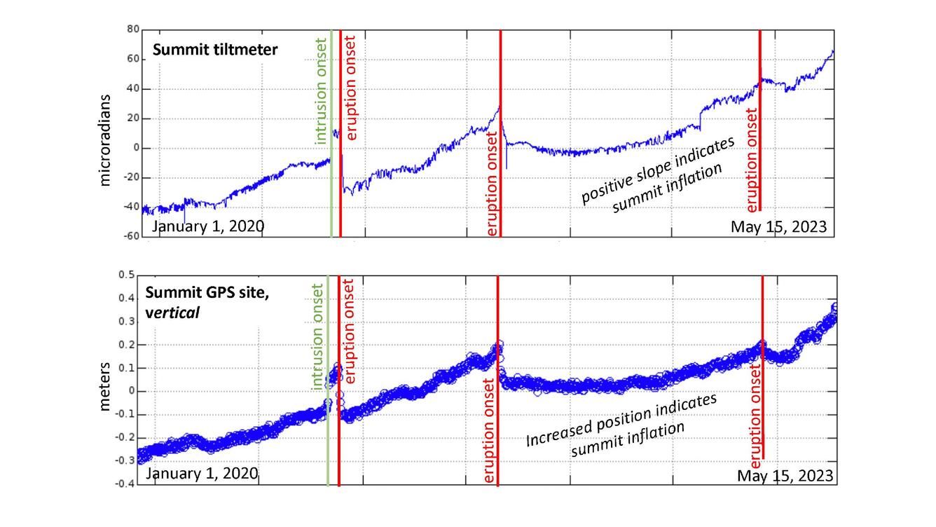
Kīlauea summit tiltmeter data (top) and summit GPS daily vertical position data (bottom) shown for the time period January 1, 2020, to May 15, 2023. Summit intrusion and eruption onsets are marked with thin vertical lines and labels. Increased positions and positive slopes in these plots are interpreted as inflation at Kīlauea’s summit. USGS plots.
Halemaʻumaʻu Crater Observations:
No active lava has been observed over the past day.
Summit Observations:
Summit tiltmeters are showing gradual inflation. Overall, inflation at the summit of Kīlauea is still higher than conditions preceding the January 5, 2023, summit eruption. We had a flurry of earthquakes in the summit and Namakani regions. No eruption of Halemaʻumaʻu. Additional flurries of earthquakes continue irregularly beneath Keanakākoʻi Crater, and the southern margin of Kaluapele (Kīlauea caldera) since April 16. Overall, rates of summit earthquakes remain elevated, and additional earthquake flurries are possible. The most recent sulfur dioxide (SO2) emission rate of approximately 151 tonnes per day was measured on May 16, 2023.
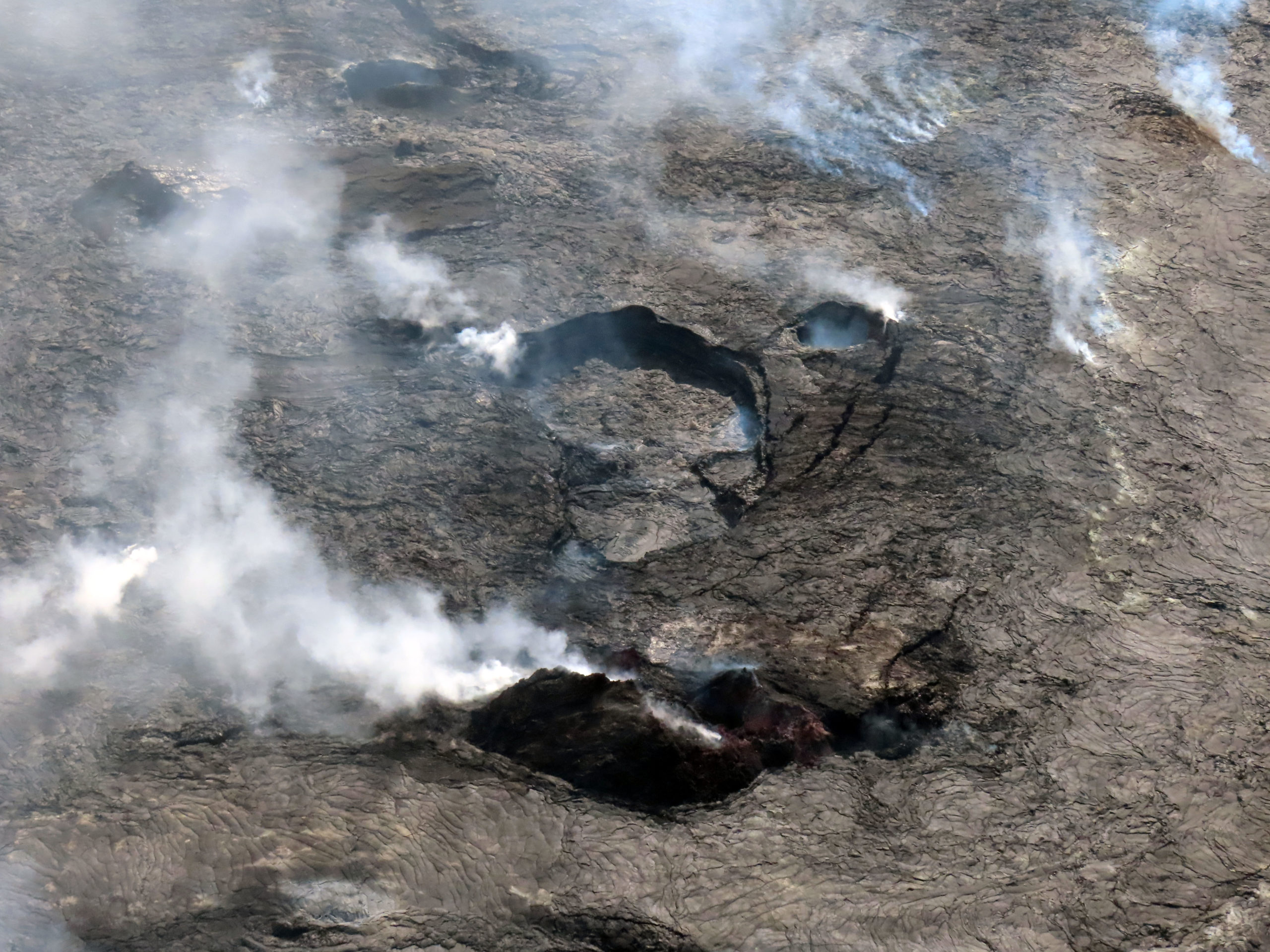
Rift Zone Observations:
No unusual activity has been noted along the East Rift Zone or Southwest Rift Zone; steady rates of ground deformation and seismicity continue along both. Measurements from continuous gas monitoring stations in the middle East Rift Zone—the site of 1983–2018 eruptive activity—remain below detection limits for SO2.
Source : HVO
Photos : USGS/J. Schmith ,