May 19 , 2023.
Italy / Sicily , Etna :
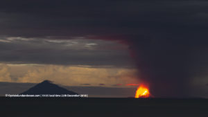
Communique on the activity of Etna, May 18, 2023, 15:05 (13:05 UTC).
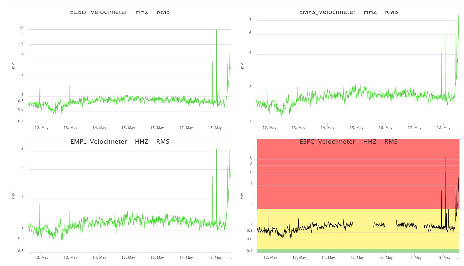
The National Institute of Geophysics and Volcanology, Osservatorio Etneo, communicates that from the seismic point of view the average amplitude of the volcanic tremor, after a brief phase of decrease, has undergone a new phase of increase in the range of high values, starting around 11:30 UTC, with a trend of further increase. Infrasound activity shows no significant change.
Due to the cloud cover, which persists in the summit area of the volcano, it is not possible to carry out volcanological observations via the video surveillance network. The simulation of the possible dispersion of the volcanic plume indicates a direction towards the eastern quadrants.
The signals from the permanent inclinometric and GNSS deformation control networks do not show any significant variations. We report a modest variation of the deformation signal at the DRUV station.
Statement on the activity of Etna, May 18, 2023, 17:43 (15:43 UTC).
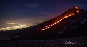
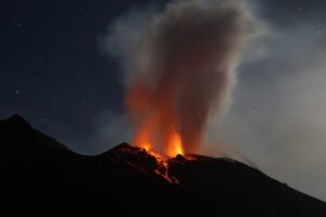
The National Institute of Geophysics and Volcanology, Osservatorio Etneo, communicates that from the analysis of images from the Bronte thermal camera, explosive activity was observed from 15:00 UTC in the Bocca Nuova crater. There are currently no reported ash emissions.
From a seismic point of view, the increase in the amplitude of the volcanic tremor continues at high values and the source of the tremor is located between the Bocca Nuova crater and the Southeast crater at a depth of about 2 .5 km. The presence of infrasonic tremor is recorded from about 15:00 UTC.
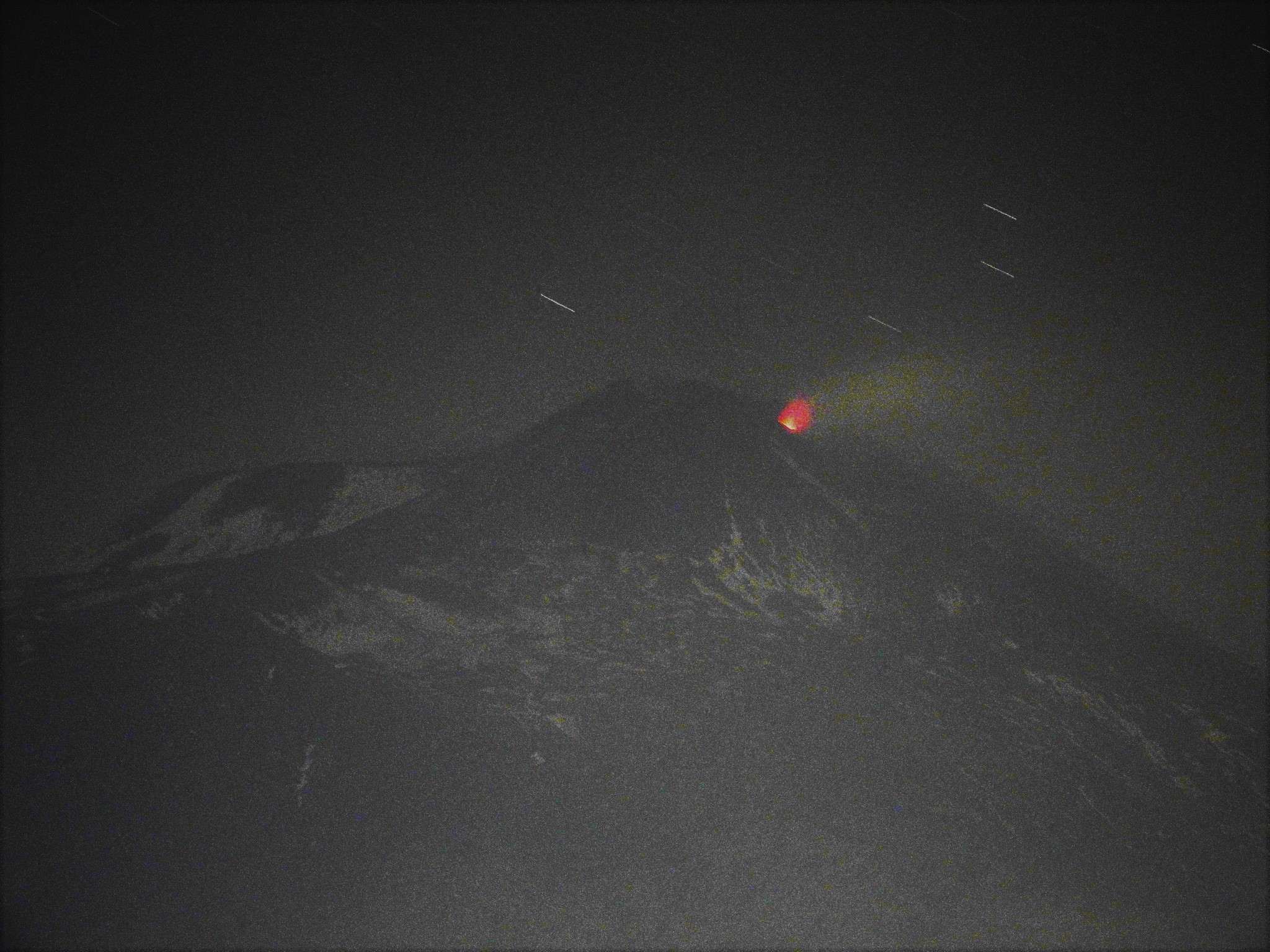
It should also be noted that a seismic swarm has been in progress since 14:44 UTC in the summit area of Etna. The most energetic event (Ml=1.9) was recorded at 15:00 UTC.
From 14:45 UTC, inclinometer variations are recorded at the summit stations (Punta Lucia and Pizzi Deneri which have currently accumulated about 2 microradians and which are visible even with very small variations at the medium altitude stations (Dammusi).
Source : INGV.
Photos : INGV , Boris Behncke.
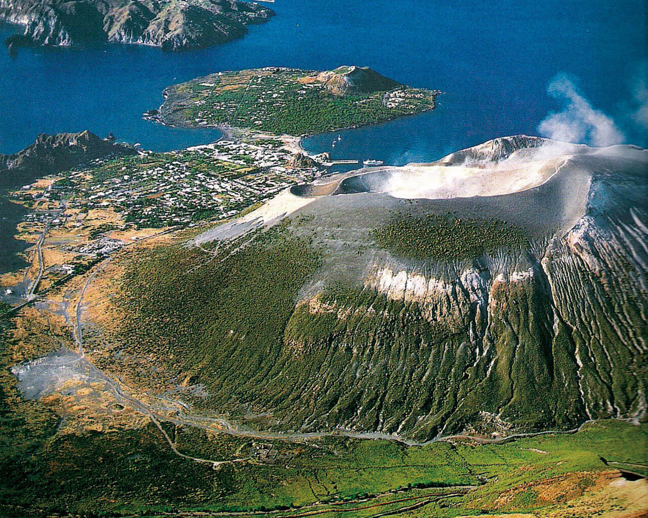
Italy , Vulcano :
WEEKLY BULLETIN, from May 08, 2023 to May 14, 2023. (issue date 16 May 2023)
ACTIVITY STATUS SUMMARY
In the light of the monitoring data, it is highlighted:
1) Temperature of the crater fumaroles: The temperature signal recorded on the rim of the crater is strongly disturbed by the episodes of intense rain but always remains at high values.
2) CO2 flux in the crater area: No update due to bad weather conditions.
3) SO2 flow in the crater area: towards an average level
4) Geochemistry of fumarolic gases: There are no updates.
5) CO2 fluxes at the base of the La Fossa cone and in the Vulcano Porto area: The CO2 fluxes recorded at the sites of Rimessa, C. Sicilia show stable values, always above background levels. On the P4max site, the flows increase slightly to high levels, while on the Faraglione site, values close to the background level are recorded.
6) Geochemistry of thermal aquifers: stable but still high temperature values are recorded in the Camping Sicilia well and do not show variations in conductivity values; in the Bambara well, no significant change in the monitored parameters was observed.
7) Local seismicity: The rate of occurrence of local events was on average low.
8) Regional seismicity: No earthquake of Ml greater than or equal to 1.0 was located in the area of the island of Vulcano.
9) Deformations – GNSS: The network of permanent GNSS stations has not recorded any significant variations.
10) Deformations – Inclinometry: The inclinometric network did not record any significant variations.
11) Gravimetry: No significant change was recorded.
12) Other Comments: Mobile GNSS.
The time series acquired so far by the mobile GNSS network do not show significant variations around the Porto di Levante area.
TEMPERATURE OF CRATERIC FUMAROLE:
The fumarolic field showed homogeneous trends along the entire summit fracture line, confirming a thermal anomaly supported by a stable vapor flux, mainly conditioned by the variability of meteorological conditions. The mission to restore the maximum temperature signal (T3), which had been out of service since April 10, was postponed due to bad weather. The sudden drops in recorded temperature values are attributable to repeated rainy phenomena, from May 2 to today.
Source : INGV.
Photo : voyages-lesiles.ch
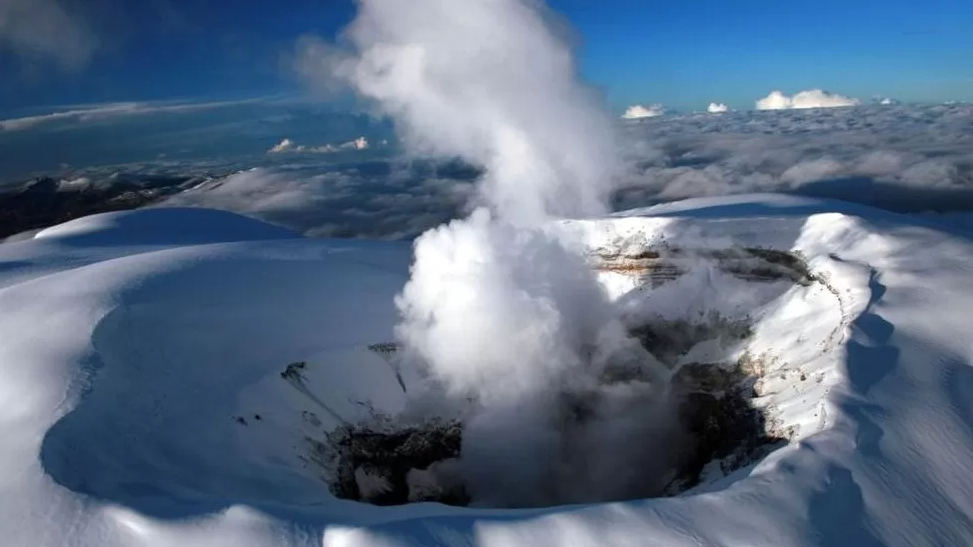
Colombia , Nevado del Ruiz :
Manizales, May 18, 2023 10:05 a.m.
Regarding the monitoring of the activity of the NEVADO DEL RUIZ VOLCANO, the MINISTRY OF MINES AND ENERGY through the COLOMBIAN GEOLOGICAL SERVICE (SGC) informs that:
From 9:00 a.m. yesterday until the time of publication of this bulletin, the seismic activity associated with the fracturing of the rock inside the volcanic edifice showed a decrease in the number of earthquakes and the seismic energy released by compared to the previous day (May 16).
This seismicity was located in the Arenas crater and in the northwest and southwest sectors of the volcanic edifice, with depths between 1 and 5 km. The maximum magnitude recorded was 0.4 corresponding to the earthquake recorded on May 17 at 6:00 p.m., located 3 km northwest of the Arenas crater and at a depth of about 5 km.
Regarding the seismicity related to the movement of fluids inside the volcanic conduits, this seismic activity has decreased both in the number of events recorded and in the
seismic energy released compared to the previous day (May 16). Yesterday and so far today, there has been no confirmation of ash emissions.
With regard to surface activity, the maximum height of the gas column was 1100 m, measured from the summit of the volcano and it presented a predominant dispersion towards the northwest of it. At dawn today, the thermal anomaly was observed at the bottom of the Arenas crater from satellite monitoring platforms. Variations in the outgassing of sulfur dioxide and the release of water vapor from the crater into the atmosphere continue.
The level of activity of the volcano remains at the ORANGE LEVEL of activity or (II): PROBABLE ERUPTION IN TERM OF DAYS OR WEEKS.
Source et photo : SGC
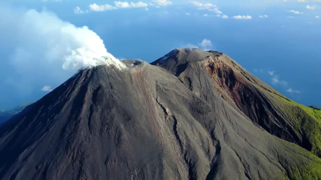
Indonesia , Karangetang :
Increased activity level of G. Karangetang, North Sulawesi, from Tier II (WASPADA) to Tier III (SIAGA)
Introduction
The volcanic activity of G. Karangetang is characterized by the growth of lava domes in the North and Main craters, the characteristics of which are effusive eruptions since February 8, 2023.
Visual observation
In April 2023, the Karangetang volcano is often cloudy to overcast. An incandescence is sometimes observed at the top of the main crater with a height of 10 m. The state of the North crater is visible with smoke coming from the crater about 25 – 200 m high, at night an incandescence above the lava dome is still visible up to about 10 m. No avalanche was observed.
In the period from May 1 to May 17, 2023, the Karangetang volcano is often cloudy. On a clear day, white crater smoke is observed with moderate to thick intensity, about 50-250 m above the summit. Visually, avalanches were observed again on May 18, 2023 sliding southwest and the South for about 1,500 m from the main crater.
Seismic observation
In April 2023 it was recorded:
61 avalanche earthquakes,
25 earthquake emissions
144 hybrid/multi-phase earthquakes,
81 shallow volcanic earthquakes,
24 deep volcanic earthquakes,
26 local tectonic earthquakes,
2 earthquakes felt on the I – MMI scale
222 distant tectonic earthquakes,
15 Continuous Tremors.
During the period from May 1 to May 17, 2023, recorded
60 avalanche earthquakes
26 emission earthquakes
39 hybrid/multi-phase earthquakes,
12 shallow volcanic earthquakes,
25 deep volcanic earthquakes,
8 local tectonic earthquakes,
3 earthquakes felt on a scale of l – ll MMI,
71 distant tectonic earthquakes.

Assessment
Visual observation of the height of the smoke column shows that there has been a change since April 22, 2023. The height of the smoke plume seems to have reached 200 m above the summit, even on May 3, 2023 it reached 250 m above the summit. Additionally, there was an avalanche from the main crater dome to the southwest and south, with a maximum slip distance of up to 1500 m from the main crater, accompanied by a rumbling that could be heard up to at the PGA post of G. Karangetang. The state of the North crater showed no significant change.
Seismic observations show that earthquakes are again recorded since May 15, 2023, up to 7 events per day and tend to increase. On May 17, 2023, avalanche earthquakes increased to 32 events. This rising earthquake condition indicates that there is a supply of magma to the surface which causes material to be added to the dome and also causes the lava dome to become unstable. The movement of magma towards the surface is then followed by an effusive eruption which has the potential to cause hot cloud avalanches.
Based on the results of visual and instrumental observations, as well as based on the results of the assessment, the level of volcanic activity on Mount Karangetang has been raised from level II (Waspada) to level III (SIAGA) from from May 19, 2023 at 10:00 WITA.
Source : Magma Indonésie.
Photos : hshdude , visit siau island (mai 2019).
Mexico , Popocatepetl :
May 18, 11:00 a.m. (May 18, 5:00 p.m. GMT)
During the last 24 hours, according to the monitoring systems of the Popocatépetl volcano, 154 exhalations accompanied by water vapor, volcanic gases and ash have been detected.
Today a small explosion was recorded at 03:56. In addition, 618 minutes of high frequency tremor and a volcano-tectonic event recorded yesterday at 12:53 p.m., with a magnitude of 1.0, were recorded.
CENACOM (National Center for Communication and Civil Protection Operations) reported this morning a slight ash fall in the city of Puebla and in the municipalities of Atlixco and Cholula, Puebla.
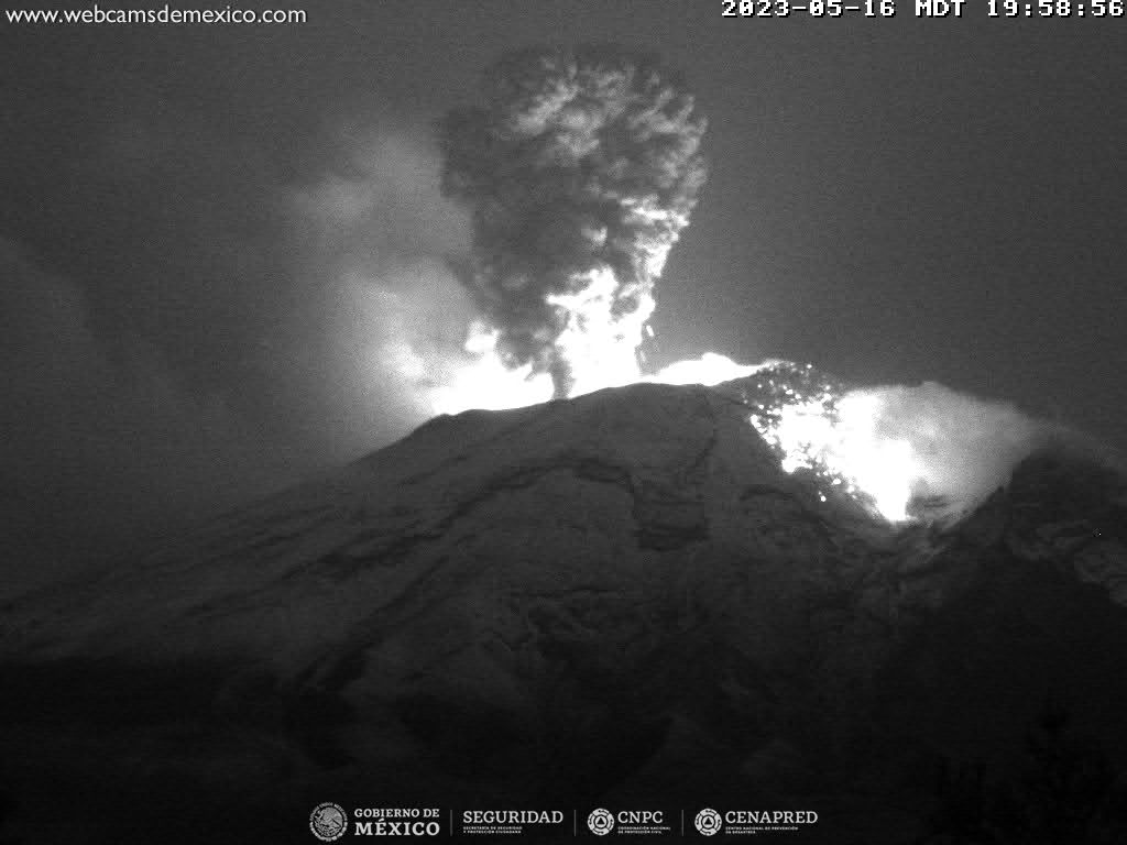
At the time of this report, although there is partial visibility towards the volcano due to weather conditions in the area, a constant emission of water vapor, volcanic gases and light amounts of ash has been observed in a direction North-East (NE) .
CENAPRED insistently reiterates the recommendation NOT TO CLIMB to the crater of the volcano, because there is the possibility of explosions, as has been seen on several occasions in the past, involving the emission of incandescent fragments. Therefore, he is required to respect the exclusion radius of 12 km. Also, in heavy rain, stay away from the bottom of ravines due to the danger of mudslides and debris.
The Popocatépetl volcanic alert traffic light is in YELLOW PHASE 2.
Source et photo : Cenapred.