May 20 , 2022.
Italy / Sicily , Etna :
Extraordinary communiqué on the activity of Etna, May 18, 2022. (issue date May 19, 2022)
UPDATE ON THE CURRENT PHENOMENON
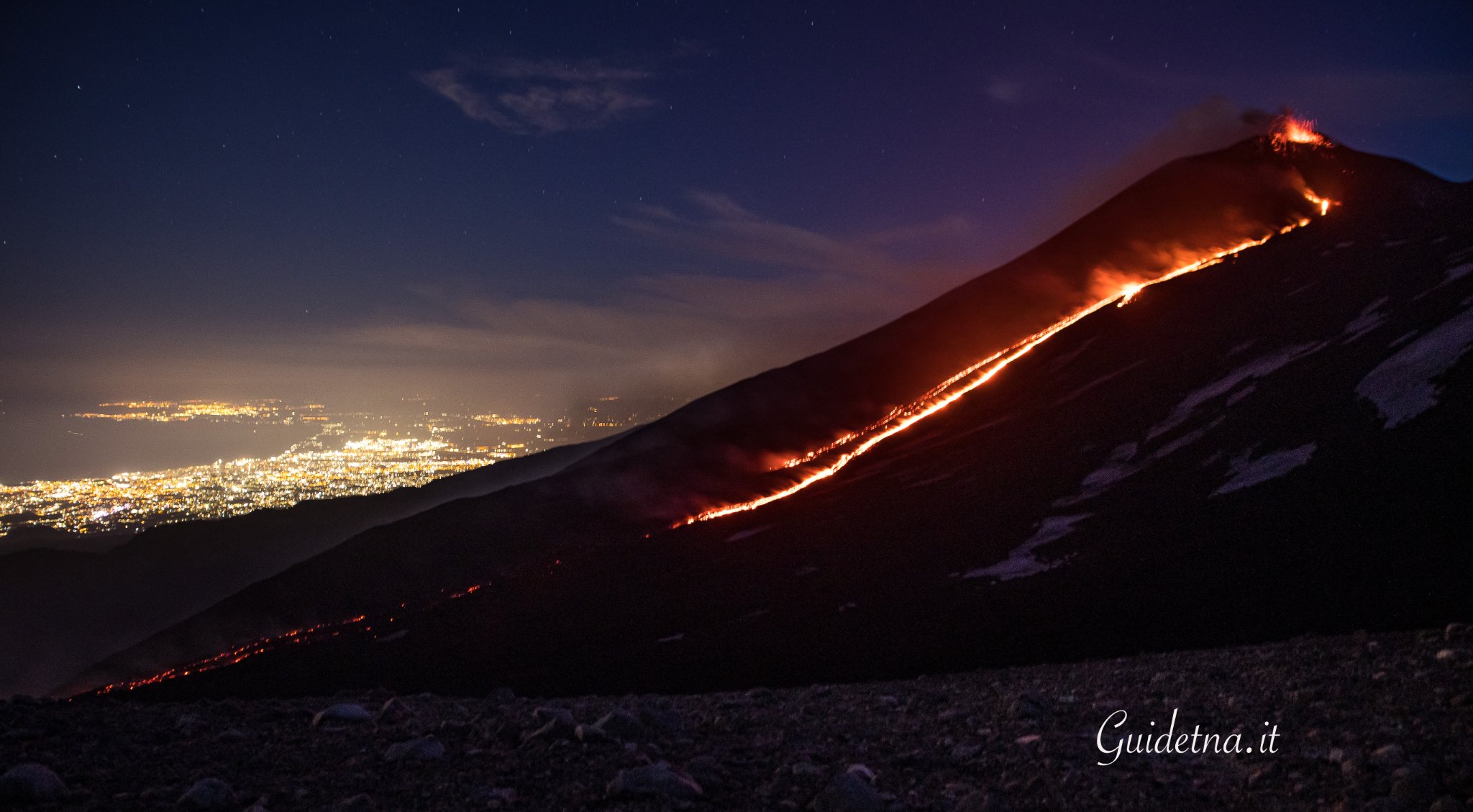
Compared to what is reported in the press release of May 17, 2022 at 15:16 UTC, it should be noted that from approximately 23:00 UTC on May 17, 2022 a new lava flow was generated from the effusive vent at an altitude of 3250 m above sea level. This flow joins the main flow which during the morning of May 18, 2022 seems to cool gradually, as evidenced by the images from the CCTV cameras. In particular, the most advanced lava front (Fig.1.1), reported in the May 17, 2022 press release and located at an elevation of about 2300 m, near Mt. Rittmann, is cooling.
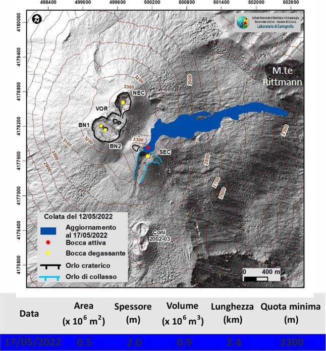
Fig. 1.1 Shaded model of the relief of the summit zone and preliminary map of the flow updated on May 17, 2022. Topographic base processed by Pléiades images of August 22, 2020 (AO Remote detection). Topographic update of the craters obtained from the photogrammetric processing of the images of the helicopter flyby of April 08, 2022.
In addition, observations made during a ground survey carried out at 09:00 UTC on 05/18/22 showed that the most advanced front of the new lava flow is located at an altitude of approximately 2700 m in the Valle del Leone.
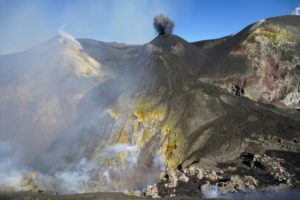
Finally, the Strombolian explosive activity at the level of the Southeast Crater continues discontinuously and with variable intensity.
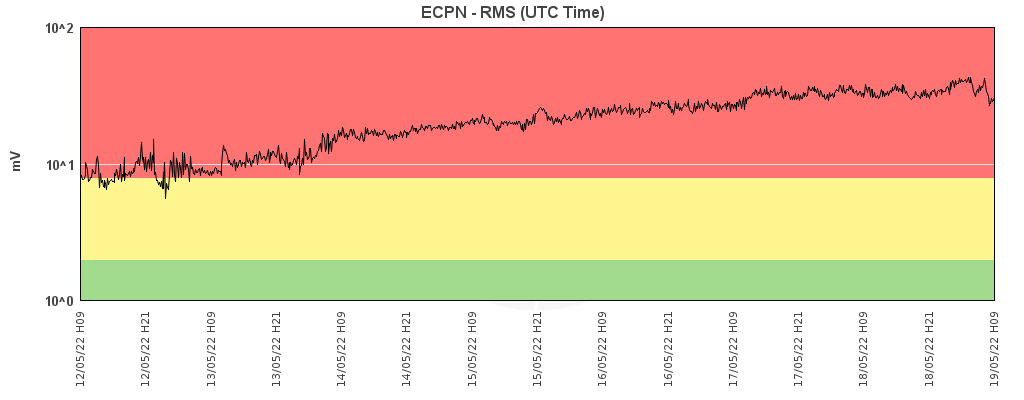
Etna’s eruptive activity was monitored with the CLHOTSAT system, processing infrared satellite images from the SEVIRI sensor for the period from May 12 to 18, 2022. The first thermal anomaly was identified on May 13 at 6:45 GMT. Thermal activity was observed continuously throughout the analyzed period until 05:00 GMT on May 18. Through thermal emission inversion, it was observed that the average eruption rate (TADR) showed an upward trend, with a peak of 5.7 m3/s on May 17 at 12:30 GMT. By integrating the values of the effusive rate during the entire eruptive period, the cumulative volume curve was also calculated, which is equal to 750,000 m3.
SEISMOLOGY
The trend of gradual increase in the average amplitude of the tremor observed since May 7 continues, which has increased the values from medium-low to high. From May 12, in particular, the values of the average amplitude show a gradual increase in the range of high values and, at the same time, the sources are located in the area of the Southeast Crater at a depth of about 3000 m. above sea level.
The seismic activity linked to the fracturing events from May 1 was weak and characterized by the occurrence of 4 earthquakes of magnitude greater than or equal to 2. Seismicity mainly affected the area of the Pernicana structural system: on May 7, 3 events with ML between 2.0 and 2.3 were located about 2.5 km north-northwest of the city of Vena, at a depth of about 300-400 meters below sea level.
GROUND DEFORMATIONS
The permanent GNSS network stations show a slight increase in the vertical component of the EPDN (Pizzi Deneri) and ECNE (Northeast Crater) summit stations from April 2022.
There is also a tendency to increase the distance between the permanent GNSS stations of ECRI (Monte Crisimo) and ECOR (Grotta del Corruccio), along the Faglie della Pernicana system, from May 6 2022.
The inclinometer stations showed a slight deformation of the ground recorded between May 6 and May 10, more visible at medium altitude stations.
In particular, the signals from the Case del Vescovo station are reported, on the southern slope of the volcano, which recorded variations of about 0.2 microradians.
With regard to the dilatometric data at the DRUV station, it should be noted that a change in slope (compression) begins on May 7, followed by a slight descent (decompression) which begins on the evening of the 12th at the start of the emission. of the lava flow.
Source : INGV.
Photos : INGV , Guide Alpine Vulcanologiche Etna
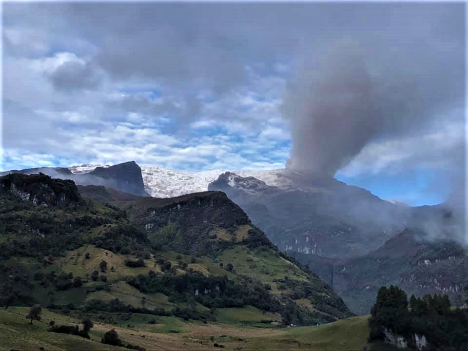
Colombia , Nevado del Ruiz :
Subject: Nevado del Ruiz volcano activity level bulletin.
The activity level continues at the yellow activity level or (III): changes in the behavior of volcanic activity.
Regarding the monitoring of the activity of the Nevado del Ruiz volcano, the COLOMBIAN GEOLOGICAL SERVICE reports that:
Seismicity related to fluid dynamics within volcanic conduits maintained similar levels in terms of the number of earthquakes and decreased in released seismic energy, compared to the previous week. This seismic activity was characterized by the occurrence of continuous volcanic tremors, tremor pulses, long and very long period type earthquakes. In general, these signals exhibited moderate to low energy levels, variable spectral content, and were located primarily within Arenas Crater. Thanks to the cameras installed in the area of the volcano and the report of the officials of the National Natural Park of Los Nevados, the gas and ash emissions associated with some of these signals have been confirmed. Likewise, thanks to the FLIR cameras of the volcanic monitoring network, changes in the relative temperature of the emitted material have been observed.
Seismicity associated with rock fracturing decreased in number of earthquakes and seismic energy released, compared to the previous week. This seismic activity was located mainly in the North-West, North-East and South-East sectors of the volcano and, to a lesser extent, in the Arenas crater and in the South-West sector of the volcano. The depth of the earthquakes varied between 0.6 and 8.0 km. The maximum magnitude recorded during the week was 2.0 ML (Local Magnitude), corresponding to the earthquake that occurred on May 10 at 3:35 p.m. (local time), located 1.5 km northeast of the Arenas crater, at a depth of 3.9 km.
The recording of several episodes of « drumbeat » type seismicity, of low energy level and of short duration, associated with the fracturing of the rocks, on May 12 stands out. This seismicity has been linked to the processes of ascent, emplacement-growth and evolution of a lava dome at the bottom of the Arenas crater.
Source : SGC.
Photo : Ramirez Jorge
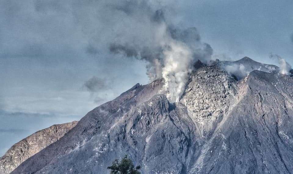
Indonesia , Sinabung :
Lowered the activity level of G. Sinabung, North Sumatra Province, from level 3 (Siaga) to level 2 (Waspada). May 18, 2022.
Since June 2, 2015, the level of activity of G. Sinabung has changed from level III (Siaga) to level IV (Awas). On May 20, 2019, G. Sinabung’s activity level was lowered from Level IV (Awas) to Level III (Siaga).
Surveillance outcome data
Visual
Visuals of the volcano during the period from January 1 to May 17, 2022 are dominated by the emission of white smoke from the main crater with high, weak to thick intensity at about 50-500 meters above the summit. Avalanches still occur, but visually the distance and direction of the slide distances are not observed. The last eruption was on July 28, 2021.
Instrumental
Seismicity in the period from January 1 to April 30, 2022 was dominated by 7 earthquakes, 176 earthquakes, 1 times earthquakes, 1 times non-harmonic earthquake, 15 times tornillo earthquake, 57 times low frequency, 291 times hybrid/phase of many earthquakes, 8 times shallow volcanic earthquakes, 96 times deep volcanic earthquakes, 135 times local tectonic earthquakes, 487 times distant tectonic earthquakes and 26 times flood earthquakes.
Seismicity in the period from May 1 to May 17, 2022 was dominated by 4 Gust earthquakes, 1 time non-harmonic earthquake, 3 times low frequency, 25 times hybrid / phase Many earthquakes, 3 times tremors shallow volcanic earthquakes, 12 times deep volcanic earthquakes, 11 times local tectonic earthquakes, 60 times distant tectonic earthquakes and 1 earthquake earthquake.
The number of deep volcanic and shallow volcanic seismicity over the past 4 (four) months has generally decreased.
Strain data over the past four months tends to be volatile with a downward trend. And the data of SO2 Son < daily emission rate of 250 tons / day with the highest emission rate of about 4000 tons / day was recorded in January 2022, with a fluctuating trend.

Seismicity in the period from January 1 to April 30, 2022 is dominated by:
7 avalanche earthquakes,
176 emissions earthquake,
1 non-harmonic tremor,
15 « Tornillos » earthquakes,
57 low frequency earthquakes,
291 hybrid/multi-phase earthquakes,
8 shallow volcanic earthquakes,
96 deep volcanic earthquakes,
135 local tectonic earthquakes,
487 distant tectonic earthquakes
26 lahar earthquakes.
In general, the number of deep volcanic and shallow volcanic seismic events over the past 4 (four) months has decreased.
Strain data for the past four months tends to fluctuate with a downward trend. And the daily SO2 emission rate data is <250 tons/day with the highest emission rate of about 4000 tons/day recorded in January 2022, with a fluctuating trend.
Conclusion
Based on the results of visual and instrumental data analysis as well as potential hazards, it is estimated that the activity level of Mount Sinabung can be lowered from LEVEL III (SIAGA) to LEVEL II (WASPADA) from the May 11, 2022 at 9:00 p.m. WIB.
Source : PVMBG.
Photos : Nachelle Homestay , Kodi Setiawan . ( archives)
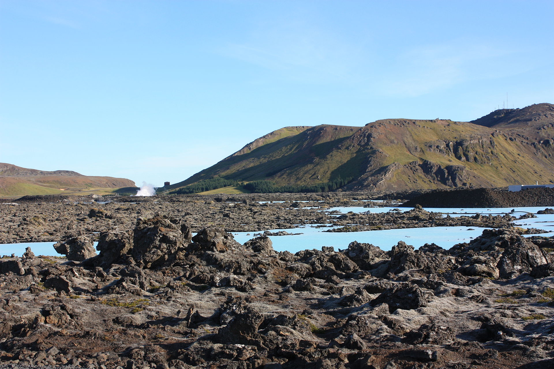
Iceland , Reykjanes Peninsula :
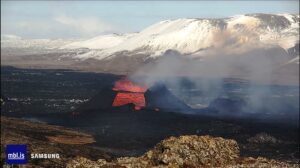
Increased magma accumulation is being recorded northwest of Þorbjörn hill, close to Grindavík, on the Reykjanes peninsula, and a lot more tension is being recorded by surface monitors in the area than at the start of this month. According to GPS data and satellite images, the accumulation in the area is similar to that in 2020 and is causing a lot of seismic activity.
The magma appears to be collecting at a depth of 4-5 kilometres, where a magma intrusion is forming, as happened three times during 2020.
Close to 4,000 earthquakes have been recorded on Reykjanes in the past week, from Eldvörp in the west to Stóra Skógfell in the east.
A civil protection agency uncertainty phase was declared at the weekend and is ongoing. The largest quake to date was of Magnitude 4.8, in the Þrengsli area, on Saturday.
Scientists still warn that a quake of up to Magnitude 6.5 could occur in Brennisteinsfjöll, and that such a quake would be very clearly felt in the capital region, knocking items over and possibly even causing some minor damage to some buildings.
Scientists are monitoring the situation closely and expect that seismic activity will continue for as long as the magma intrusion continues. Will it result in another volcanic eruption like the one that attracted visitors from all over the world last year, or will the intrusion simply peter out as happened three times in 2020? It is currently impossible to say.
Scientists are largely in agreement, however, that the Reykjanes peninsula has entered a new phase of activity that will likely see regular volcanic eruptions over the coming few centuries.
Source : RUV.
Photo : Arian Zwegers
New Zealand , Lake Taupō :
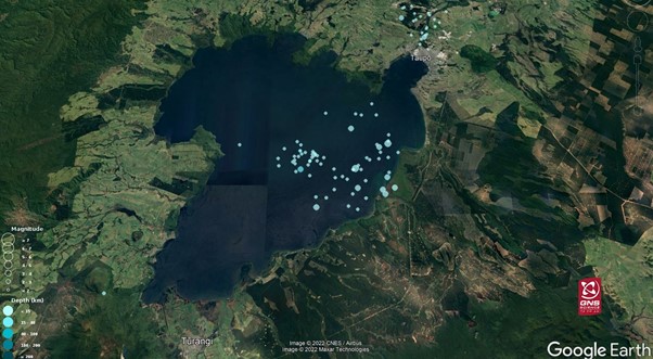
Earthquake swarm beneath Lake Taupō. Posted: Fri, May 20, 2022 4:55 PM .
The GeoNet earthquake monitoring network has recorded a small swarm of earthquakes at Lake Taupō over the last 2-3 weeks.
What’s happening?
We’ve located over 84 earthquakes under Lake Taupō since 28 April, with only two of these being over M3 in size. Earthquakes in the Lake Taupō area are typically shallower than 15 km, and the recent events are no different, with depths ranging from 3-16 km.
The recent earthquake activity has been grouped in two places under the lake. A cluster trending NE-SW along the east shore and a cluster in the middle of the lake. There have also been earthquakes to the north, around the Wairakei geothermal system, as you can see in the image below. Only a few of the larger quakes in this sequence have been felt locally.
Earthquake swarms are common in the Taupō Volcanic Zone (TVZ), and several are recorded each year. The swarms can be related to the active faults in the TVZ and volcanic processes at the caldera volcanoes like Taupō and Okataina. Larger ones have lasted weeks-to-months and can include many hundreds of earthquakes.
In the last 10 years we have located over 4,200 earthquakes under Lake Taupō. These are part of the activity that defines the background level of unrest for Taupō Volcano. The recent earthquakes are in a similar location to a series of earthquakes in 2019 that were studied in detail by the ECLIPSE programme (see below). That study showed the earthquakes are related to the margins of the hot mush zone under the volcano and are signs that Taupō volcano is active. Variations in the level of background unrest are common for caldera volcanoes like Taupō.
We know that Taupō is still active because it shows signs of what we call ‘volcanic unrest’: small earthquakes, movement of the ground up and down, and changes in the geothermal fields in the area. There have been at least 17 episodes of volcanic unrest at Taupō in the last 140 years that have been above the background levels.
Source : Geonet.
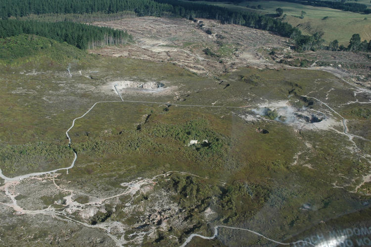
Photos : Google / GNS , Geonet ( Craters of the Moon, Taupo.)